
Time stamps on all posts are in EST, even though we are on CST. This means the posts were made 1 hour earlier in local time vs what the time stamp shows.
+++++++++++++++++++++++++++++++++
I need to be at the airport at 4:30 am Saturday for a flight to Detroit, so I won't be tracking the storms past midnight or so
Added: I ended up NOT sleeping much.
Previous thread:
Severe weather outbreak 3-12-25
Started by metmike - March 12, 2025, 11:46 a.m.
https://www.marketforum.com/forum/topic/110407/
++++++++++++++++++
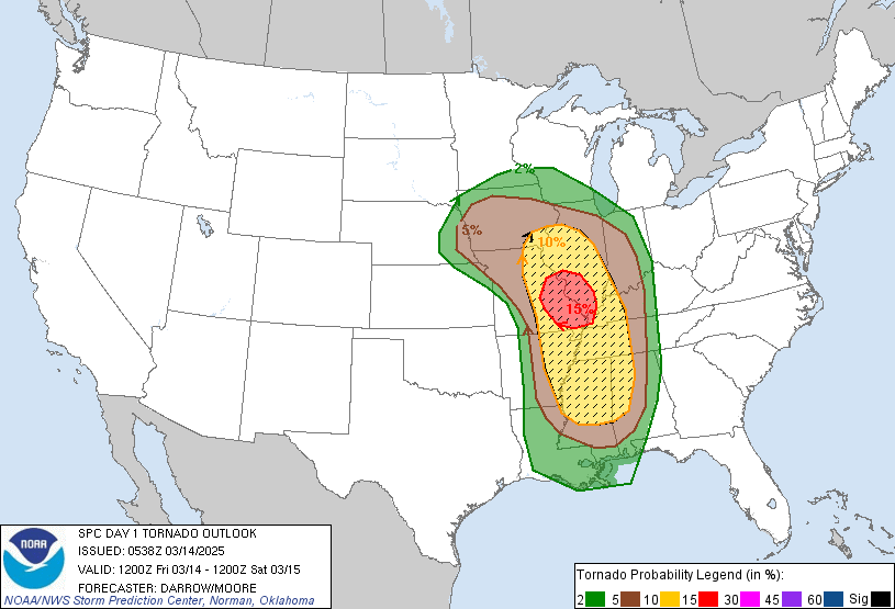
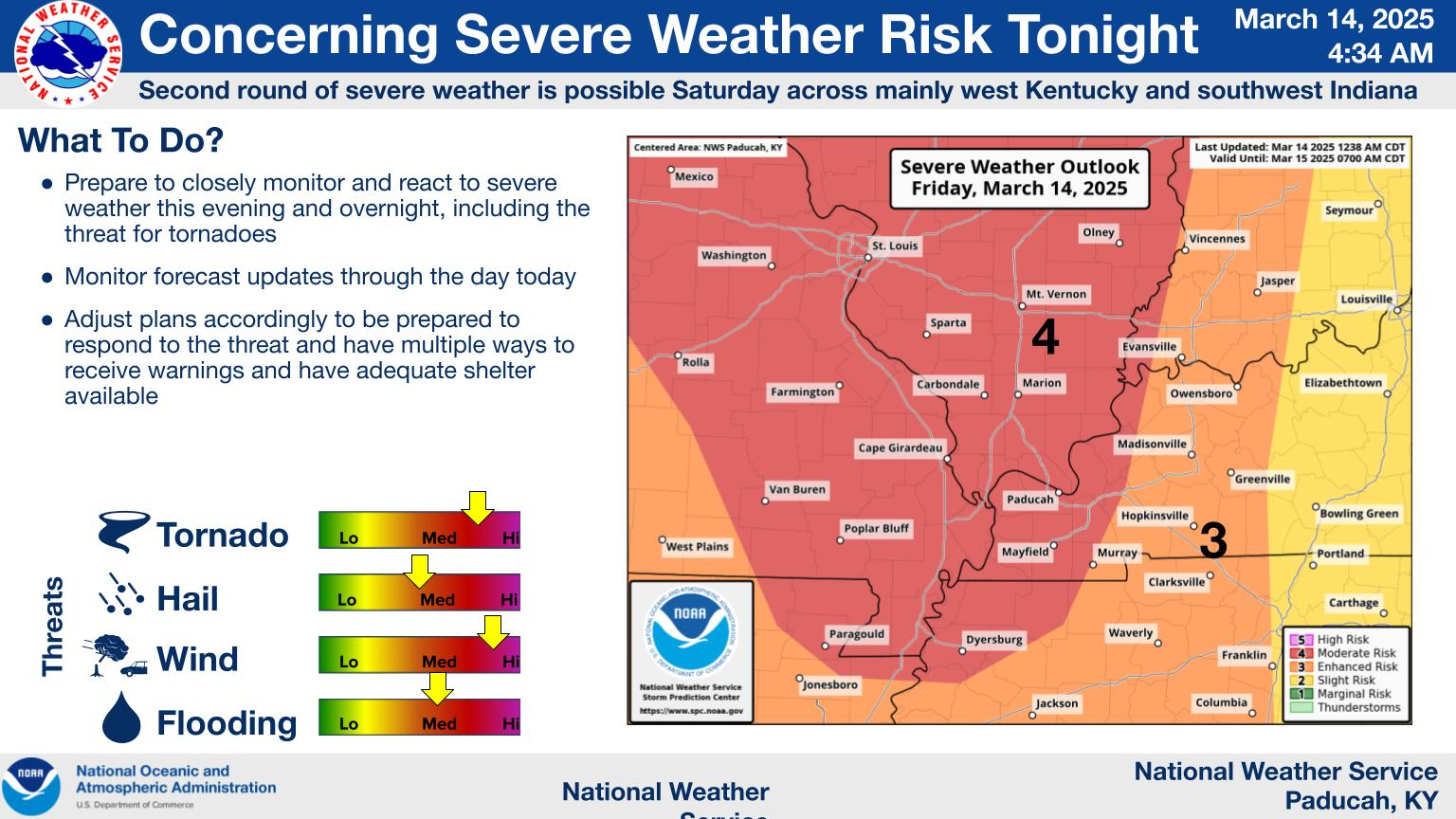
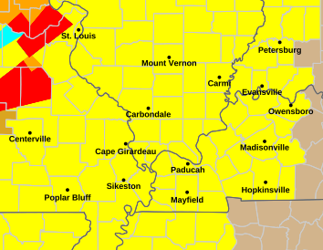
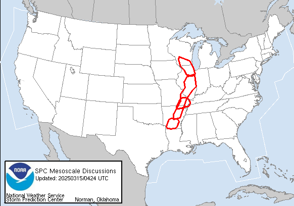
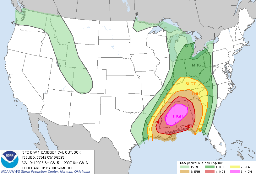
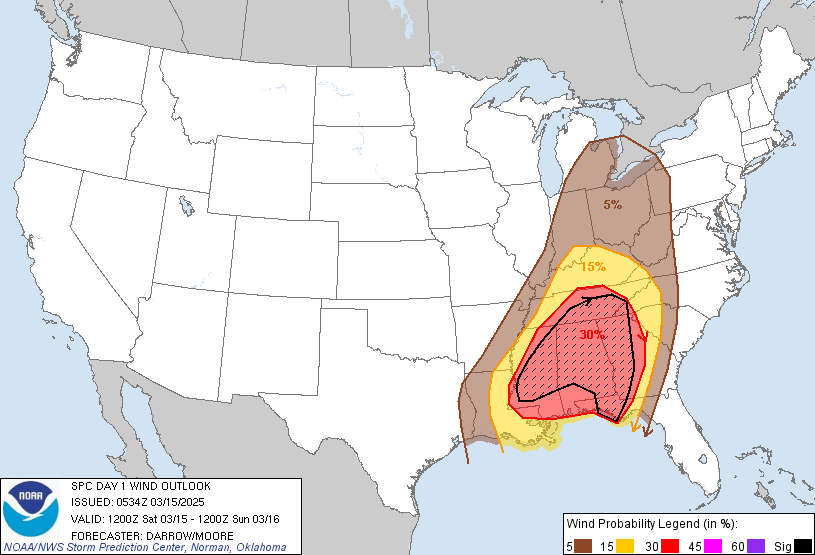
This is the day 1 outlook(thru early Saturday Morning) with radar and watch boxes.

++++++++++++++++++++++++
Tornado threat:
Probability of a tornado within 25 miles of a point.
Hatched Area: 10% or greater probability of EF2 - EF5 tornadoes within 25 miles of a point.
+++++++++++++++++++++++++++++
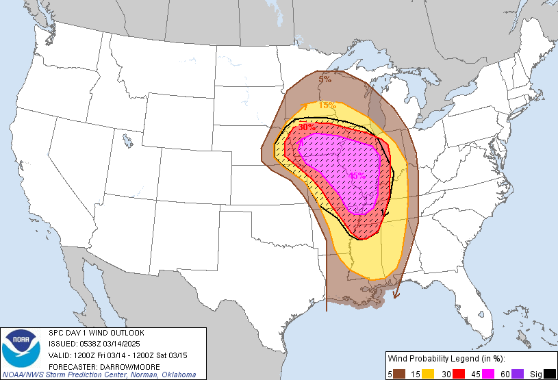
High wind threat:
Probability of damaging thunderstorm winds or wind gusts of 50 knots or higher within 25 miles of a point.
Hatched Area: 10% or greater probability of wind gusts 65 knots or greater within 25 miles of a point.
ALL the weather for every time frame is here:
Watches and Warnings will be on this map.
Current Hazards at the link below.
For your NWS and county, go to the link below.
Then you can hit any spot on the map, including where you live and it will go to that NWS with all the comprehensive local weather information for that/your county.

https://www.wunderground.com/maps/radar/current

+++++++++++++++++++++++
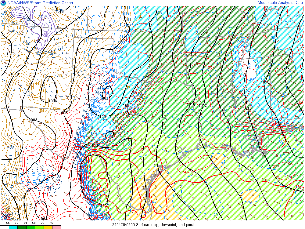
This link below provides some great data. After going to the link, hit "Mesoanalysis" then, the center of any box for the area that you want, then go to observation on the far left, then surface observations to get constantly updated surface observations or hit another of the dozens of choices.
| SPC Mesoscale Analysis Pages (National Sector Archive
|
Mobile Version) Click here to view a multimedia introduction of the Mesoanalysis Pages. (5.8MB)
| ||||||||||||
 |
| |
https://thermastor.com/dew-point-and-weather-maps/

Current Conditions below updated every few minutes.
UPPER MIDWEST
https://www.spc.noaa.gov/exper/mesoanalysis/new/viewsector.php?sector=13#

https://www.spc.noaa.gov/exper/mesoanalysis/new/viewsector.php?sector=13#

https://www.spc.noaa.gov/exper/mesoanalysis/new/viewsector.php?sector=13#

LOWER MIDWEST
https://www.spc.noaa.gov/exper/mesoanalysis/new/viewsector.php?sector=20

https://www.spc.noaa.gov/exper/mesoanalysis/new/viewsector.php?sector=20#

https://www.spc.noaa.gov/exper/mesoanalysis/new/viewsector.php?sector=20# 
SOUTHCENTRAL
https://www.spc.noaa.gov/exper/mesoanalysis/new/viewsector.php?sector=15#
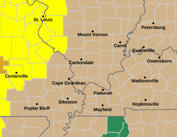
Here's the Evansville link with some information:
https://www.weather.gov/pah/weatherstory
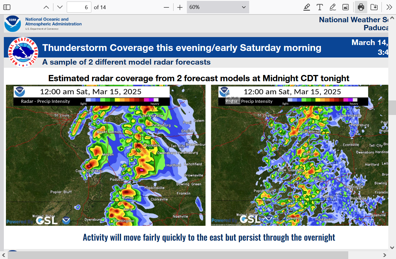
Metmike: Storms may be scattered and either approaching or hitting Evansville at Midnight(on the faster model)
https://www.weather.gov/media/pah/DssPacket.pdf
Watches, Warnings and radars are all lighting up.
This is the day 1 outlook(thru early Saturday Morning) with radar and watches.
This tornado watch expires at 11pm, which suggests the storms will still be WELL to our west then and likely not arriving until well after midnight. This is POTENTIALLY good news with a later arrival time. The storms have a better chance to weaken as:
1. The cooler temperatures stabilize the air mass a bit.
2. They run out away from their main support farther west.
https://www.spc.noaa.gov/products/watch/ww0032.html
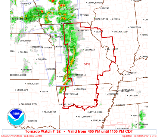
The later it is for the storms with this particular line, the better the chance for them to weaken. We need a few hours of tracking them to have more confidence on their arrival time.
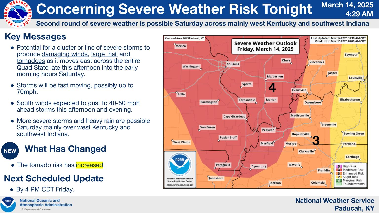
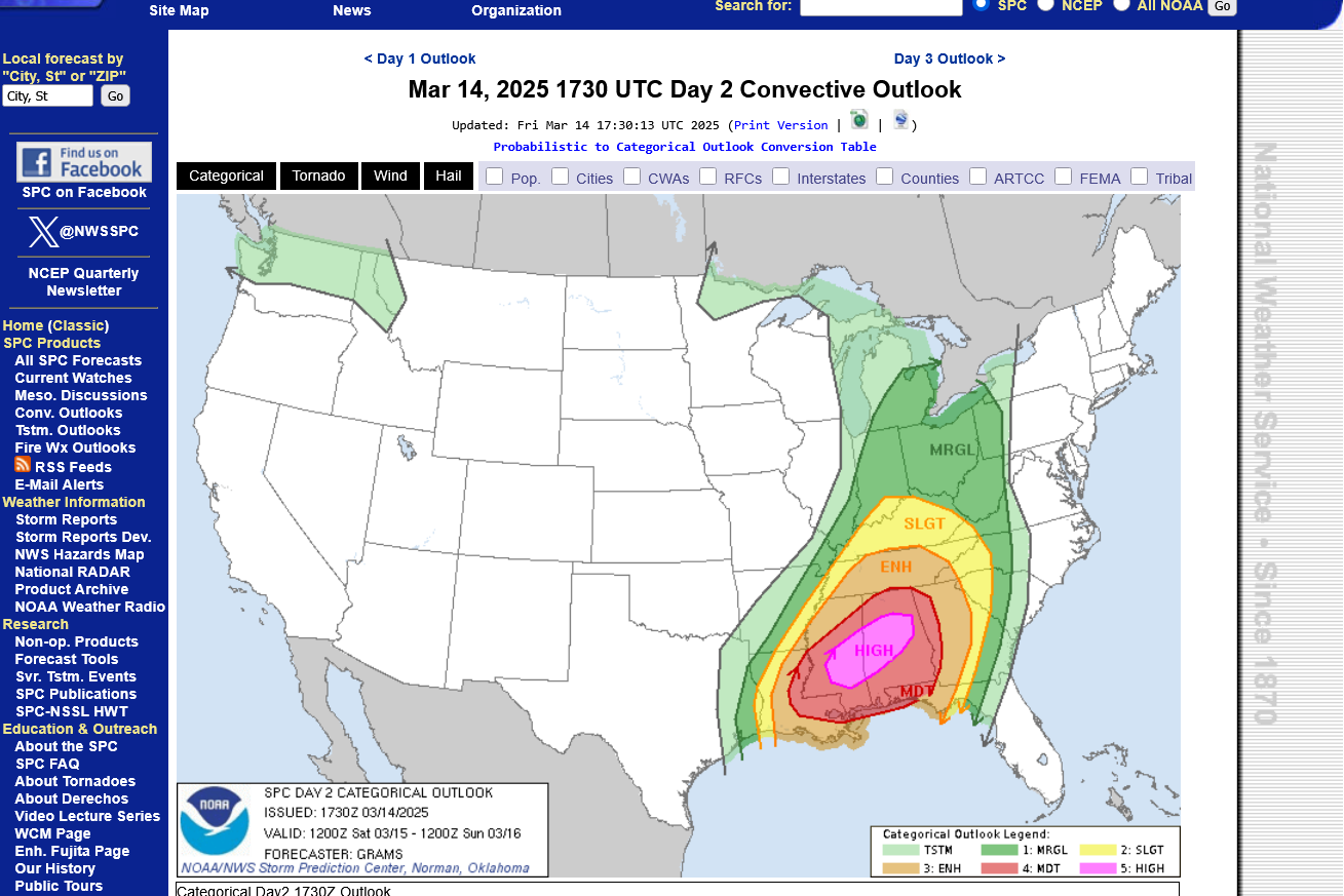
Saturday's threat will include a rare HIGH risk in parts of the South. Unfortunately, I will be traveling all day. Flying to Detroit, then driving back with my recently passed Dad's car.
https://www.spc.noaa.gov/products/outlook/day2otlk.html
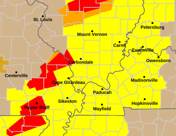
We've got our Tornado Watch Box out until 3am. We're in the northeast corner so it's likely the storms that hit Evansville will be arriving towards the expiration time of the watch box.
Note their wording:... THIS IS A PARTICULARLY DANGEROUS SITUATION... This means the risk of a strong, F2 or higher tornado. Chances are that these storms will be in a weakening mode at that time but that's not a guarantee.
The Storm Prediction Center will be giving us several updates on the storms between now and when they get here.
https://www.spc.noaa.gov/products/watch/ww0036.html
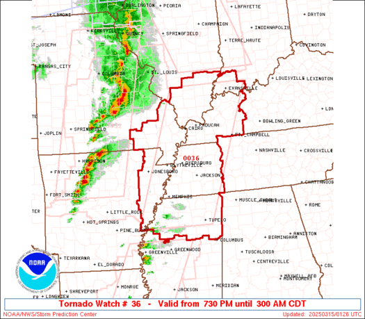
The Storm Prediction Center will be giving us several updates on the storms between now and when they get here.
They will do that with constantly updated mesoscale discussions.
You can view those here:
https://www.spc.noaa.gov/products/md/
Current Mesoscale Discussions
Updated: Sat Mar 15 00:17:02 UTC 2025
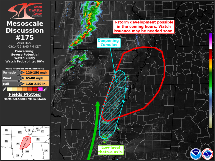
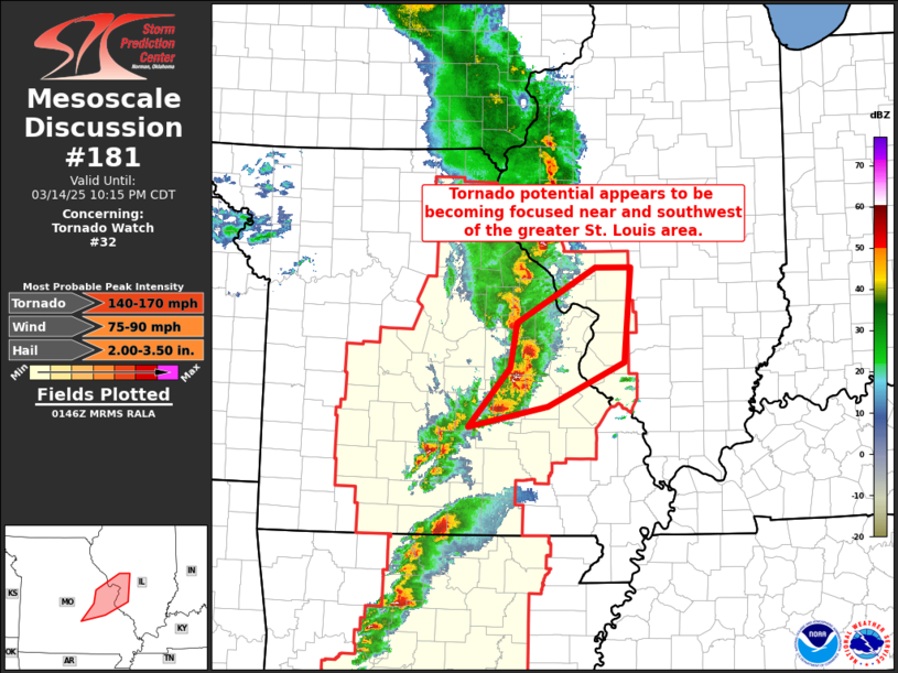
Here's at 8:30pm, all those mesoscale discussions are still west and south of Evansville but within a couple of hours, they will include our area.
We can see the storms getting closer now with tornado warnings just west, southwest of St. Louis:
We're picking up the leading edge up on the radar.
The intensity of the reflected beam may not be as impressive in some cases as a Summer Storm with high heat/moisture reflecting back the radar beam effectively. However, what they have is a very impressive WIND FIELD. The type that defines many Spring severe weather outbreaks. Also in Winter, when the instability of a 70 deg. C dew point is impossible.
Spring storms are defined by and get their energy from a strong temperate contrast/gradient, that can NEVER happen in July. This causes the pressure gradient and powerful winds(upper level winds/jet streams) that are the recipe for violent tornadoes.
We have many more thunderstorms in the Summer but usually non severe. Severe storm outbreaks in March will sometimes NOT look as impressive as a similar NON severe line of storms in July.

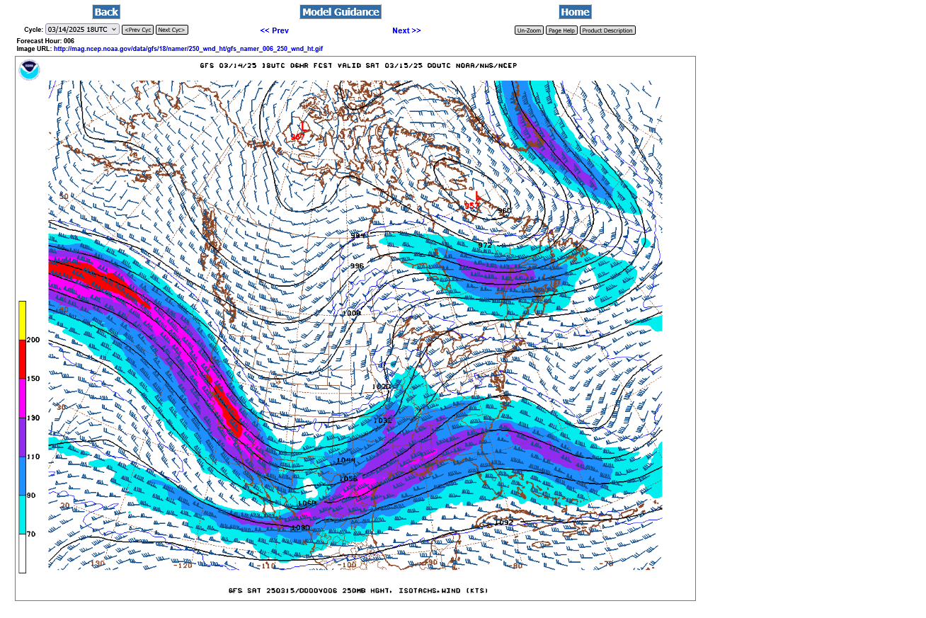
This temperature contrast below is causing the deepening surface low pressure storm as well as correlating to a strong jet stream(that lifts the air and provides spin/rotation).
Upper Midwest
https://www.spc.noaa.gov/exper/mesoanalysis/new/viewsector.php?sector=13#
LOWER MIDWEST
https://www.spc.noaa.gov/exper/mesoanalysis/new/viewsector.php?sector=20
++++++++++++
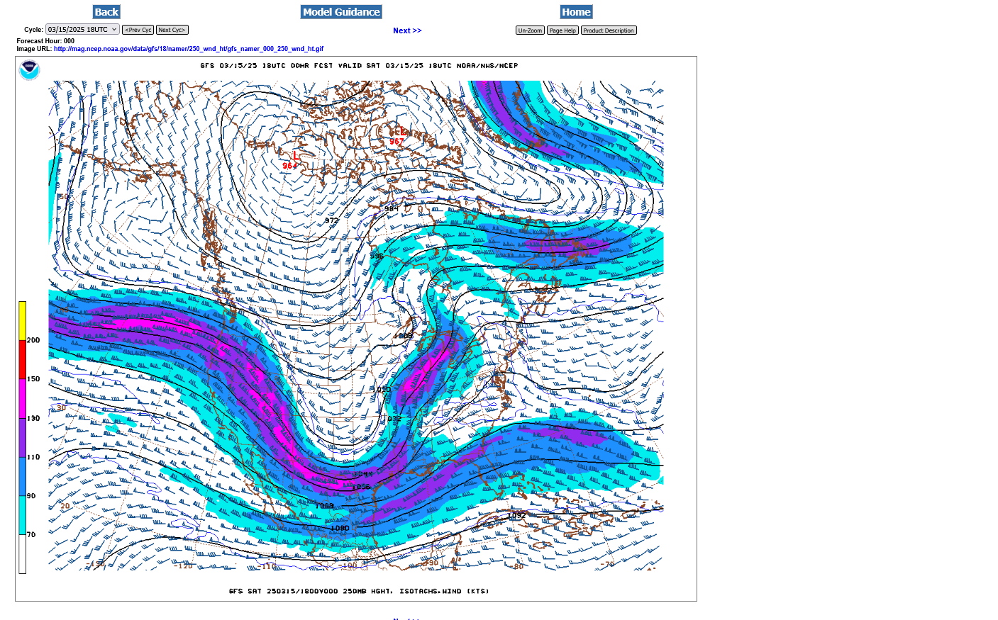
The upper level jet stream right now is pretty strong but not the greatesthighest. Look to the West Coast to see the RED color denoting a jet streak embedded in the jet stream at close to 200 mph. This will "dig into" and DEEPEN the upper level trough and cause it to become negative tilted! Targeting places in the South that have a HIGH, level 5 risk on Saturday. The highest of all.
There is still the chance for some severe storms in Evansville tomorrow PM.
Current 250 mb map below:
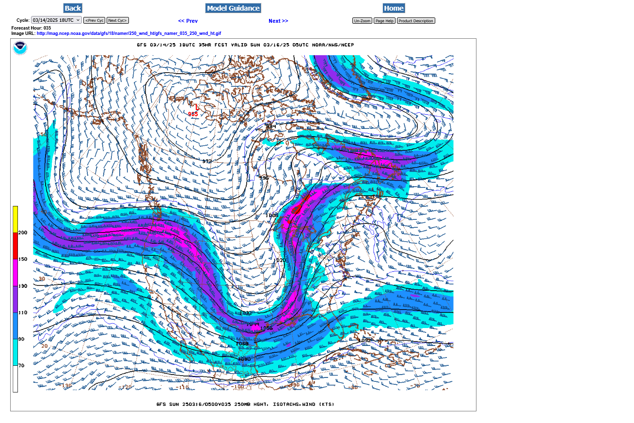
Late Saturday below:
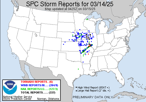
So far, only 3 tornadoes reported:
https://www.spc.noaa.gov/climo/reports/today.html
| < 250313 Reports 250314 Reports > |
| |||||||
 | |||||||
https://www.spc.noaa.gov/products/md/
https://www.weather.gov/pah/weatherstory
Just 6 tornadoes so far. 284 severe thunderstorm high wind reports. 127 hail reports.
https://www.spc.noaa.gov/climo/reports/today.html
I need to be up at 4am to fly to Detroit.
Good Night!
Back awake….but not on the computer
Storms have NOT weakened.
Still a substantial risk for a tornado when they come thru just after 2am.
Warnings all around us but mostly for severe thunderstorms.
no strong tornadoes reported. Just storms capable of a tornado according to the NWS.Rhese storms don’t look as strong as the ones that went thru St. Louis several hours ago but we need to let the NWS be the boss with their radar.
We had a few minutes of small hail@and lost power briefly so I had to reset my clock and alarm but its almost time to get up anyway.
Looks like we will get thru another one with no major problems.
Timestamps here are always in Eastern Time.
Tornado outbreak in the South later today. I'll be in an airplane to Detroit then back in a car.
https://www.spc.noaa.gov/products/outlook/day1otlk.html

On the airplane, getting ready to take off:
Huge tree blocking my way to the airport earlier this morning. Had to take a different route
Just got back from Detroit.
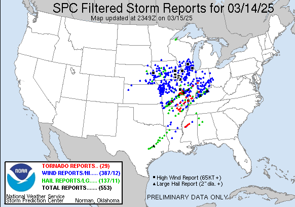
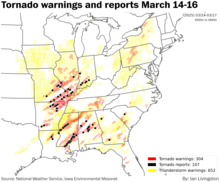
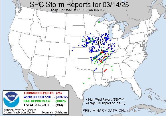
This was yesterdays severe weather outbreak(6am Fri-6am Sat) Over 500 reports, especially severe thunderstorm winds, 387(wind gusts of 55 mph+)!!! That will likely be in the top 3 severe weather outbreaks for 2025. This is PRELIMINARY data. When the local NWS does a survey of the damage and reports they will make a definitive ruling for the final number.
The black squares were wind gusts over 75 mph. Black triangles were hail of 2" or more.
https://www.spc.noaa.gov/climo/reports/250314_rpts.html
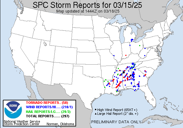
Storm reports so far on Saturday, starting at 6am. 76 is alot but nothing like yesterday!
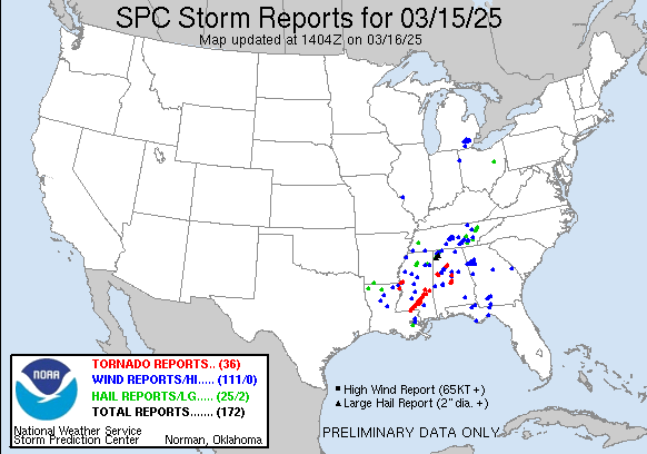
9am, Sunday: Update map below show 172 TOTAL REPORTS. Note, what looks like a long track strong tornado, moving across much of Southern MS.
https://www.spc.noaa.gov/climo/oreports/250315_rpts.html

Yesterday's deep low pressure storm lifted up to Canada with some waves developing along the very slow moving cold front in the South underneath the strongest upper level support/jet stream.
Freeze frame below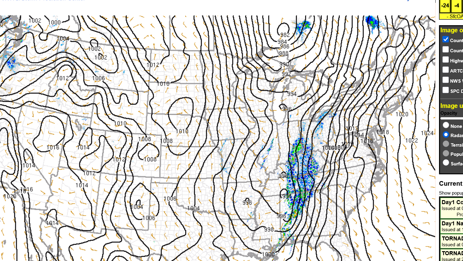
Constantly updated below:
https://www.spc.noaa.gov/exper/mesoanalysis/new/viewsector.php?sector=19&parm=pmsl
 +++++++++++++++++++++++
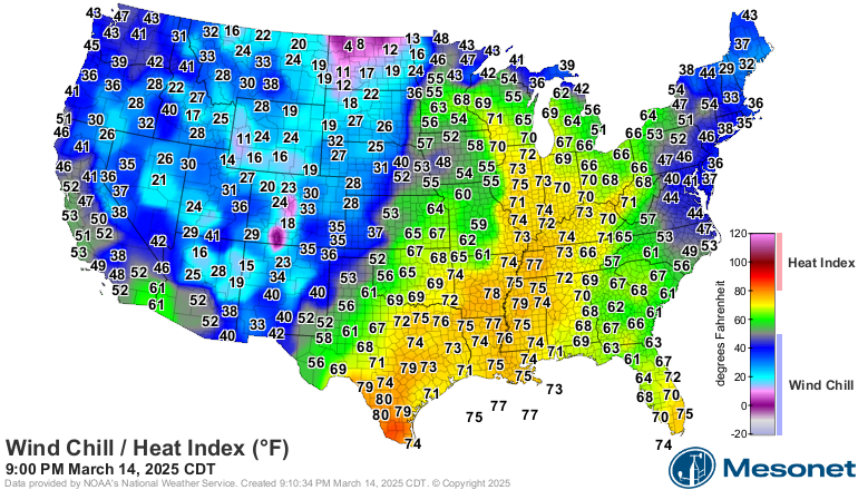
70's in the Southeast on the warm side of the front. Below freezing in northern MO, Single digits in northern MN.
Cold temps that contrast greatly from warm temps on either side of a front/surface low, along with the strong jet streams which evolve from this dynamic often define severe weather outbreaks.
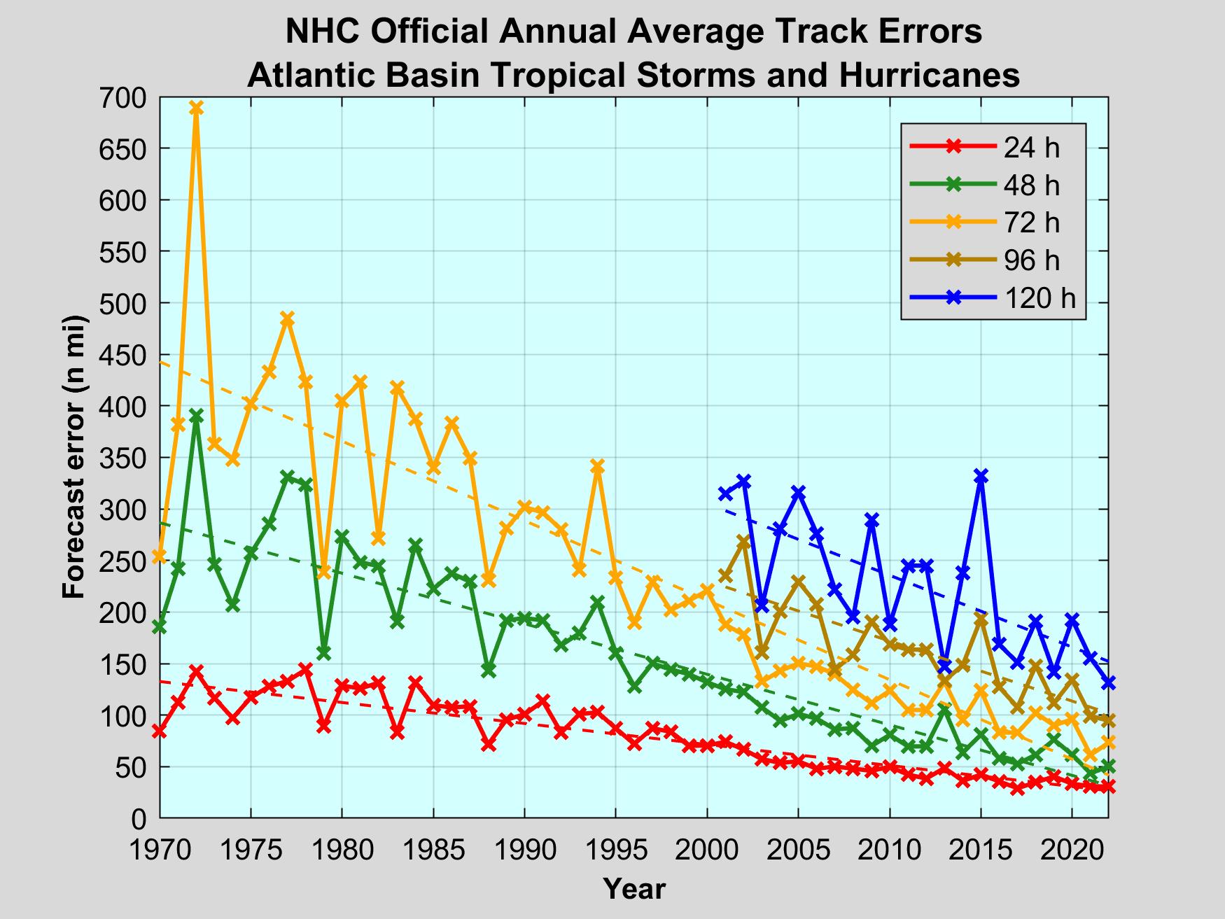
Warming the most in the higher latitudes from climate change REDUCES this temperature gradient and this has resulted in around a 50% reduction in VIOLENT tornadoes the last 3+ decades.
The actual tornado count suddenly jumped higher in the early 1990's with the advent of NEXRAD Doppler radars being installed across the country at NWS's, that can now SEE THE WIND and SEE TORNADOES that went undetected previously. Increased spotter coverage too. The increase has been entirely for the WEAKER tornadoes.
Counting method for the violent tornadoes remains the same. Those kind of tornadoes, even before Doppler radars left behind enormous trails of damage, so almost all of them were already being counted before.
With Doppler radar., we just see them much sooner and often 30+ minutes before touching down. So people are warned well in advance.
The Great Tri-State tornado almost 100 years ago, along with all the other tornadoes in that age were detected when people saw them coming with their eyes. Or witnessed their destruction in real time when their property or house was being damaged/destroyed.
https://www.marketforum.com/forum/topic/110418/
https://www.marketforum.com/forum/topic/110445/#110473
9am, Sunday: Updated map below show 172 TOTAL REPORTS the previous 24 hours(Saturday). Note, what looks like a long track strong tornado, that moved across much of Southern MS.
https://www.spc.noaa.gov/climo/oreports/250315_rpts.html
Here's the Storm Prediction Center's outlook BEFORE that tornado and BEFORE any watches were issued.
They nailed it! They are the best! As in THE best in the world at what they do by a wide margin. They continue to save more lives every time there's an outbreak/event like this.
https://www.marketforum.com/forum/topic/110445/#110469
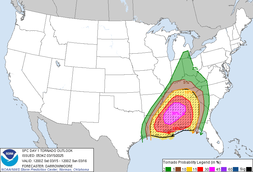
This was their outlook from the prior day and the map showing actual severe weather reported below it.
Are they good or are they THE BEST?
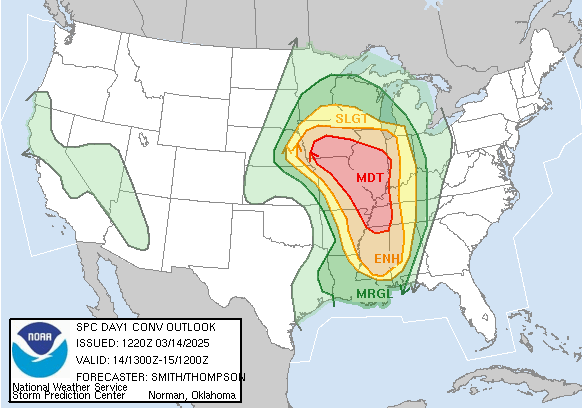
https://www.spc.noaa.gov/climo/reports/250314_rpts.html

SPC Products |
| The Storm Prediction Center (SPC) is part of the National Weather Service (NWS) and the National Centers for Environmental Prediction (NCEP). Our mission is to provide timely and accurate forecasts and watches for severe thunderstorms and tornadoes over the contiguous United States. The SPC also monitors for hazardous winter weather and fire weather events and issues specific products for those hazards. We use the most advanced technology and scientific methods available to achieve this goal. |
https://www.spc.noaa.gov/public/misc/about.php
++++++++++++++++++++++++++++++
Machine learning model helps forecasters
improve confidence in storm prediction
file:///C:/Users/Basement/Downloads/2023-03-machine-confidence-storm.pdf
++++++++++++++
https://www.ll.mit.edu/r-d/projects/intelligent-tornado-prediction-engine
To train and validate such deep learning models, we compiled a massive open-source dataset called TorNet. Containing more than 200,000 radar images, TorNet is intended as a benchmark to advance tornado research within the machine learning and weather science communities.
Using TorNet, we developed tornado detection models. Our deep learning model performed similar or better than all others known in the literature, correctly classifying over 85% of tornadoes rated EF-2 or higher. We also evaluated other types of models to compare against. The parameters of these models are freely available and described in our paper.
+++++++++++++++++
https://inria.hal.science/hal-02799277v1
Submitted on 8 Jun 2020
HAL is a multi-disciplinary open access
archive for the deposit and dissemination of sci-
entific research documents, whether they are pub-
lished or not. The documents may come from
teaching and research institutions in France or
abroad, or from public or private research centers.
Distributed under a Creative Commons Attribution 4.0 International License
Real-Time Tornado Forecasting Using SLHGN
https://inria.hal.science/hal-02799277/document
https://link.springer.com/chapter/10.1007/978-3-030-32169-7_8
The advancing technology is helping severe weather forecasting to gradually improve in other realms too!
https://starlinwdoria.pages.dev/crqkbj-national-hurricane-center-predictions-2024-hmicnv/
https://earthsky.org/earth/tornadoes-hard-to-forecast-predictions-improving/
+++++++++++++++++++
This article is over 2 decades old but still very informative, capturing the period that saw NEXRAD Doppler radars installed across the country(1990s).
I was the chief (and only one at the time) meteorologist at WEHT in Evansville In from 1982-1993, mostly BEFORE the NEXRAD radars. In the early days, most warnings were issued AFTER the storm was observed and reported.
The technology today is light years better!
Tornado-Warning
Performance in the Past
and Future—Another
Perspective
https://www.weather.gov/media/mdl/Glahn_2005_CommentsOnTornadoWarning.pdf
https://www.weather.gov/pah/Mar14-15_2025Severe
Evansville is near the center of this map but shifted to the right and up a tad.
| A potent late winter/early spring storm system brought widespread severe thunderstorm to the Mid Mississippi River valley starting late on Friday, March 14th, continuing into the overnight hours early Saturday, March 15th. These fast moving storms produced a variety of hazards, including several tornadoes, damaging wind, and sporadic large hail. Large hail damaged windows, siding, roofs, and vehicles in many communities. Numerous areas were impacted by damage to homes, machine sheds, power lines, and trees as well. *** Tornado tracks are still being surveyed and information will be added to this event summary as it becomes available. *** | 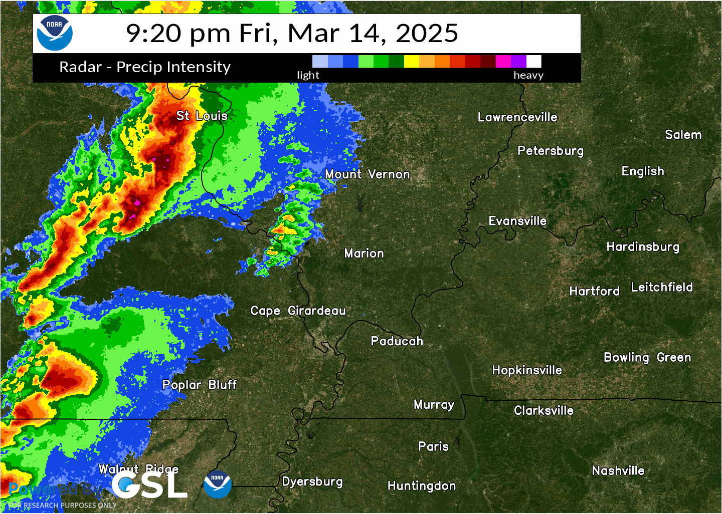 |
Tornado #7 - Oakland City, IN
GIBSON COUNTY
| Date | March 15, 2025 |
| Time (Local) | |
| EF Rating | EFx |
| Est. Peak Winds | |
| Path Length | 8.8 miles (very prelim) |
| Max Width | |
| Injuries/Deaths | xx / x |
| Summary: This tornado produced an intermittent damage path from east of Union, northeastward to Oakland City. Other damage southwest of this area could be associated with this same tornado. | |
Track Map

Likely an EF1 tornado.
Turns out that the local NWS surveys of damage, TRIPLED the number of tornadoes from last Friday's outbreak, compared to the preliminary reports(made in the dark) after looking at the damage profiles.
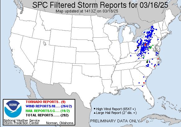
The total for severe reports, just that 24 hour period is now at 955 which, when combined with Saturday and Sunday will hopefully stand as the WORST outbreak for 2025!
1. Friday
2. Saturday
3. Sunday
https://www.spc.noaa.gov/climo/reports/250314_rpts.html
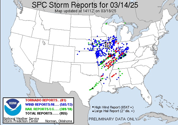
We were on the eastern edge of the Friday/early Saturday(14/15th) outbreak! The part on the map above that impacted the lower Midwest (down to Arkansas) to the Western Ohio River Valley.
We should note the southwest to northeast path of tornadoes.
If you want to spot an approaching tornado, have a clear view of the southwest horizon! However, that doesn't work very well in the dark
This is why there was a massive UNDER counting of tornadoes, initially on the first outbreak day that has been tripled after the surveys.
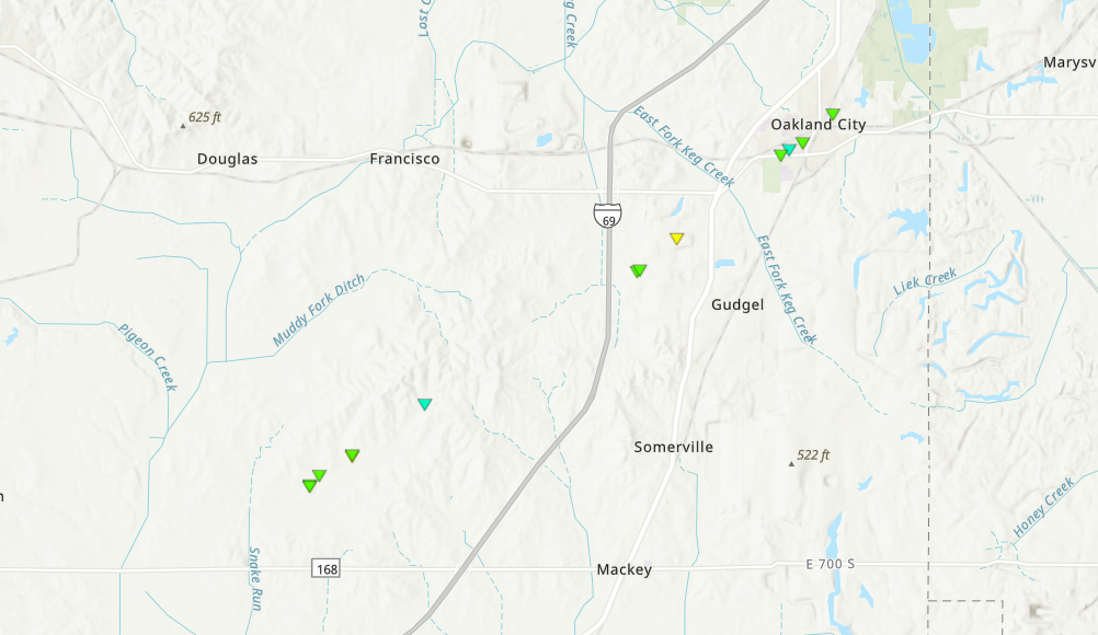
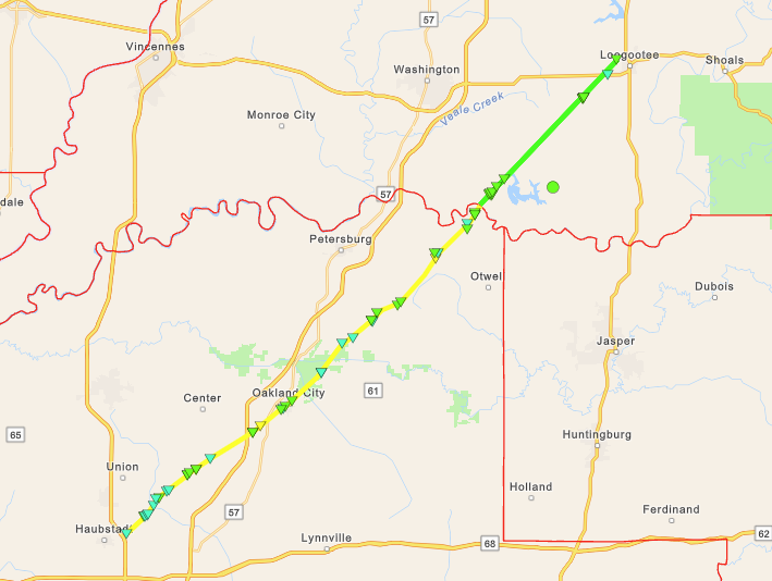
Update on the tornado just north of Evansville. This was a LONG TRACK(47 miles) EF2(barely) tornado with 120 mph winds. It was 1/4 of a mile wide at times.
It was on the ground for 39 minutes!
https://www.weather.gov/pah/Mar14-15_2025Severe
Tornado #8 - Oakland City, IN
GIBSON, PIKE, AND DAVIESS COUNTIES
| Date | March 15, 2025 |
| Time (Local) | 2:53 - 3:32 AM CDT |
| EF Rating | EF-2 |
| Est. Peak Winds | 120 mph |
| Path Length | 47 miles (33.6 miles in our forecast area) |
| Max Width | 400 yards |
| Injuries/Deaths | 0 / 0 |
| Summary: An EF-2 tornado began just east-northeast of the Tristate Speedway near Haubstadt. Some damage to outbuildings and power poles occurred, along with many trees that were uprooted as it moved northeast crossing Highway 168 and eventually Interstate 69. It produced roof damage to a church and canopy damage to a Gas Station to the southwest of Oakland City. Several trees were uprooted through town and one mobile home was severely damaged. Drone footage confirmed that the path continued into Pike County and eventually into Daviess County. The track continued for another 13.6 miles in Daviess County. | |
Track Map
Downlo