The next severe weather event (Sunday)is NOT going to be a major outbreak (with strong tornadoes) anything close to the one earlier this month!! The main risk is damaging winds.
Previous thread on the MAJOR severe storm and tornado outbreak:
Tracking Severe Weather-3-14-25
https://www.marketforum.com/forum/topic/110445/
+++++++++++++++++++++++
Get all the constantly updated weather here:
https://www.marketforum.com/forum/topic/83844/
I'm not overly impressed with the dynamics with this weekend system, so at this time it does NOT look like a major outbreak with widespread tornadoes.
Stay tuned. It's the weather and there will likely be changes.
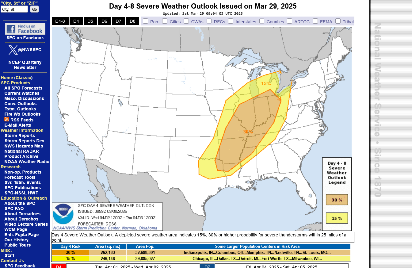
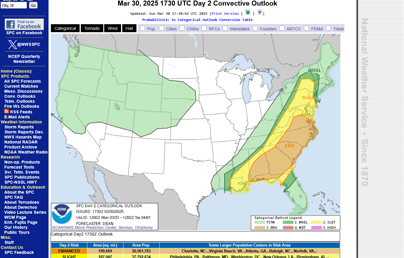
I will initially guess that we will be in the slight, level 2 to enhanced level 3 out of 5.
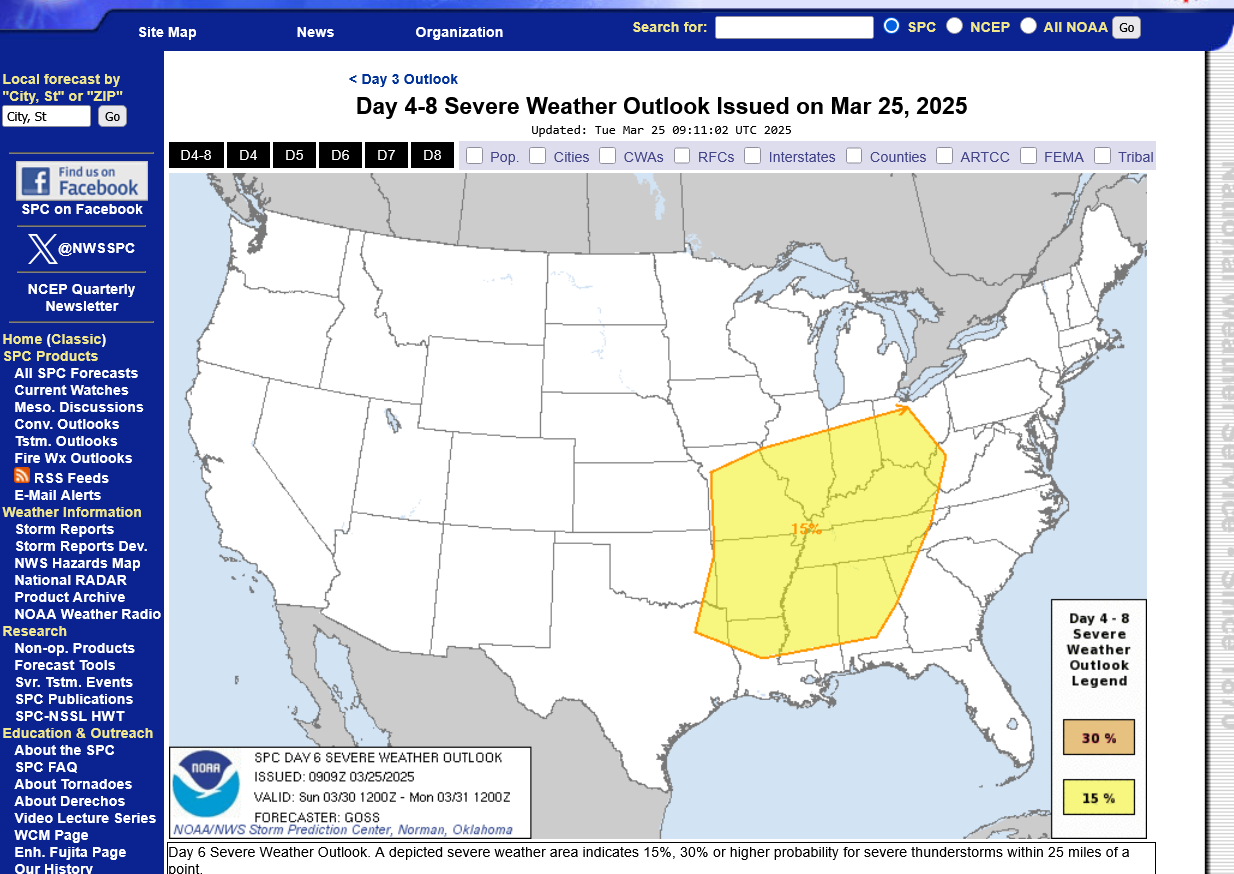
This is the day 6 outlook, here on Tuesday for the upcoming Sunday 3-30-25 from 6am to 6am Monday 3-31-25
https://www.spc.noaa.gov/products/exper/day4-8/#
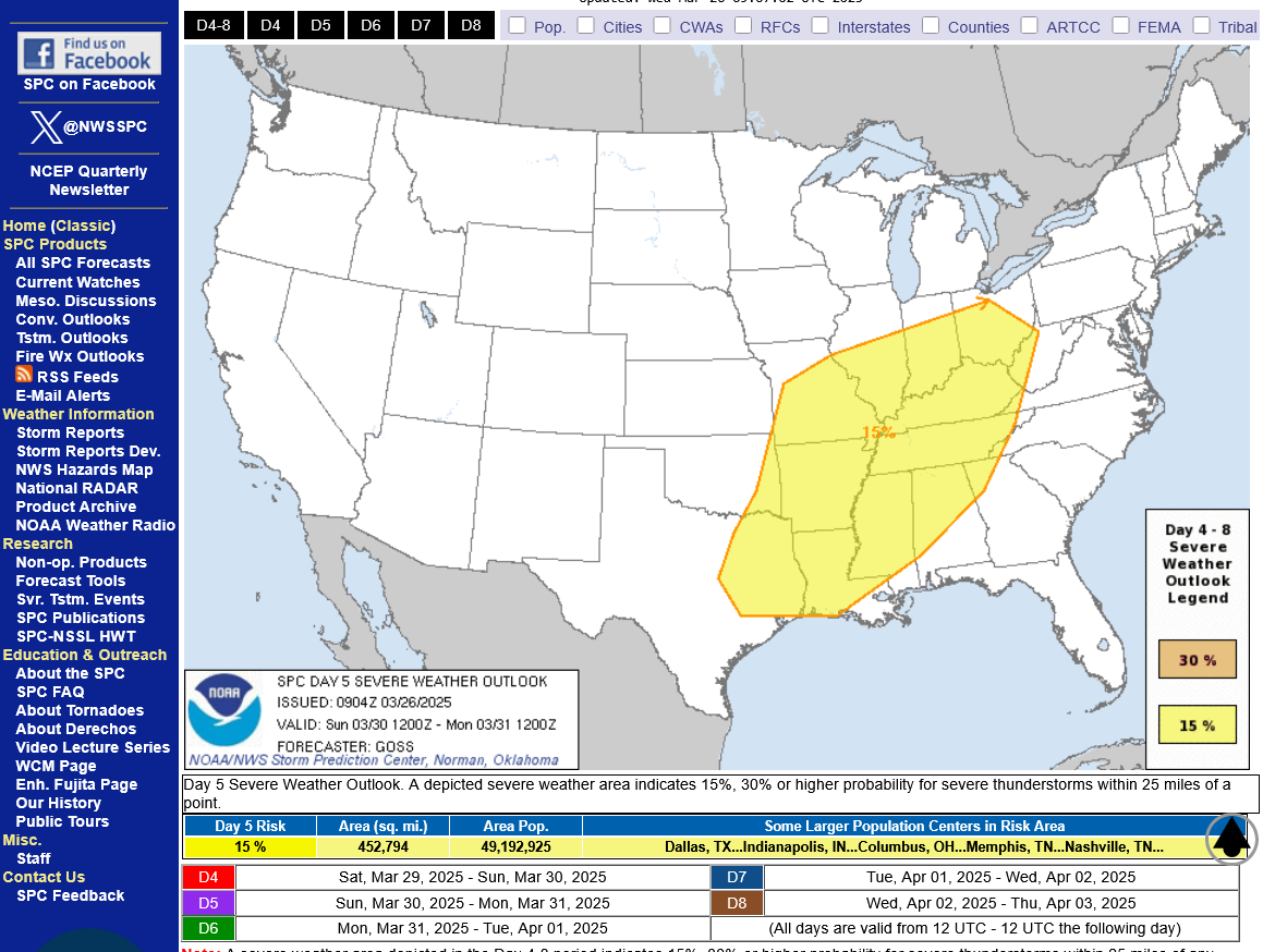
This is the updated DAY 5 outlook here on Wednesday:
This is the updated Day 4 outlook here on Thursday. We'll get a more refined outlook, starting tomorrow=Day 3!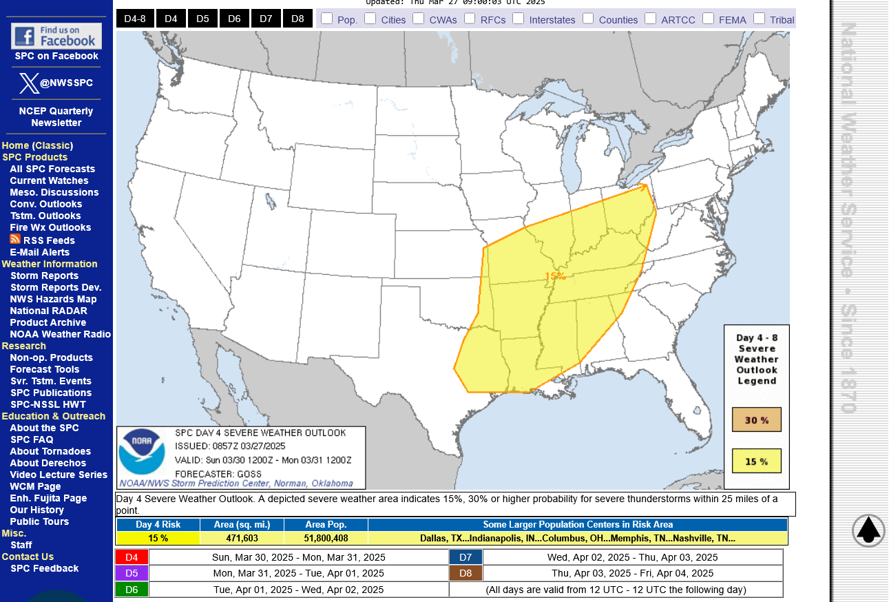
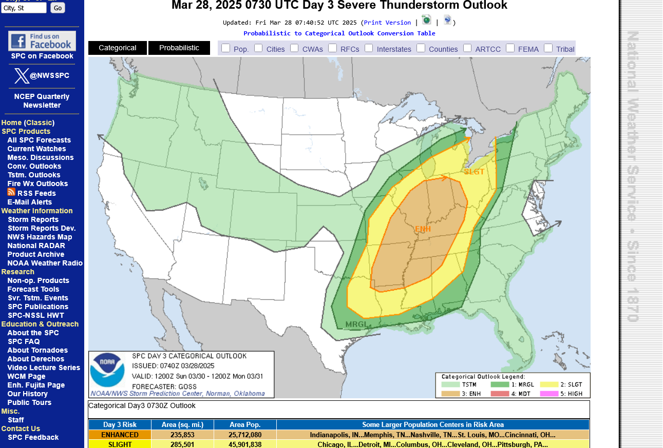
This is the updated Day 3 outlook here on Friday. They added the enhanced area, level 3 risk as expected.
https://www.spc.noaa.gov/products/outlook/day3otlk.html
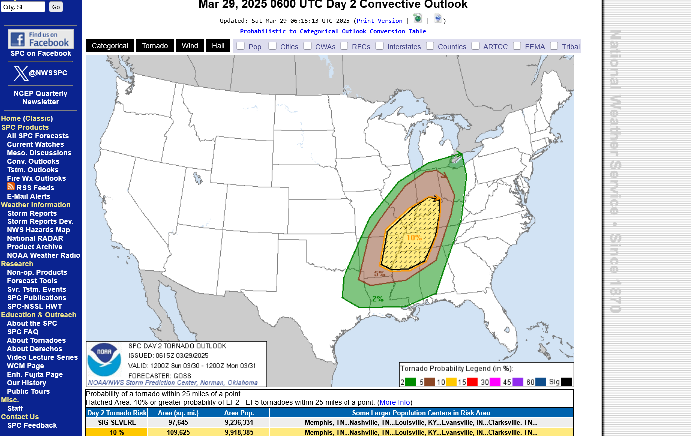
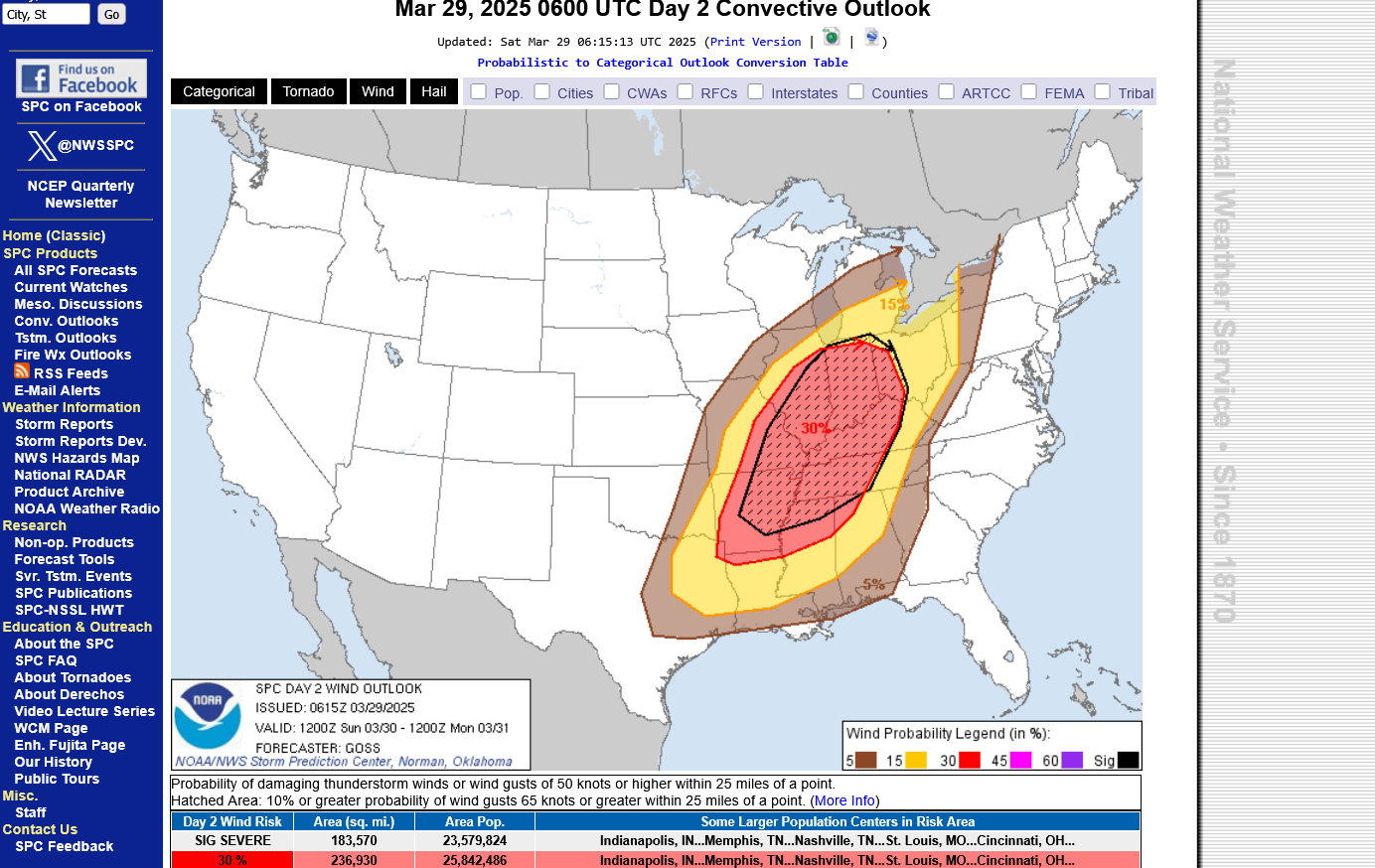
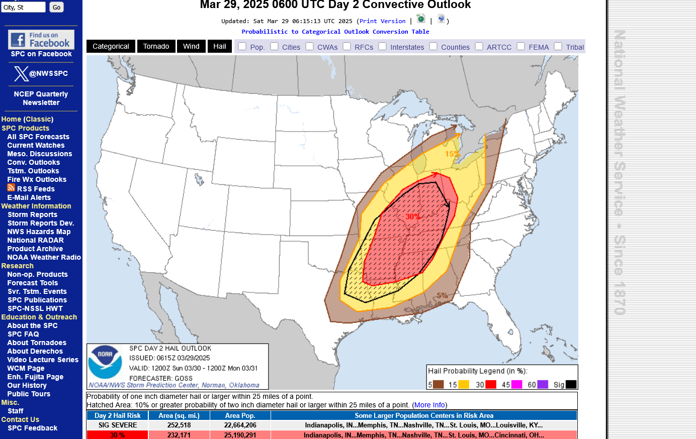
This is the updated Day 2 outlook(tomorrow/Sunday). https://www.spc.noaa.gov/products/outlook/day2otlk.html

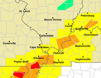
TORNADO RISK BELOW:
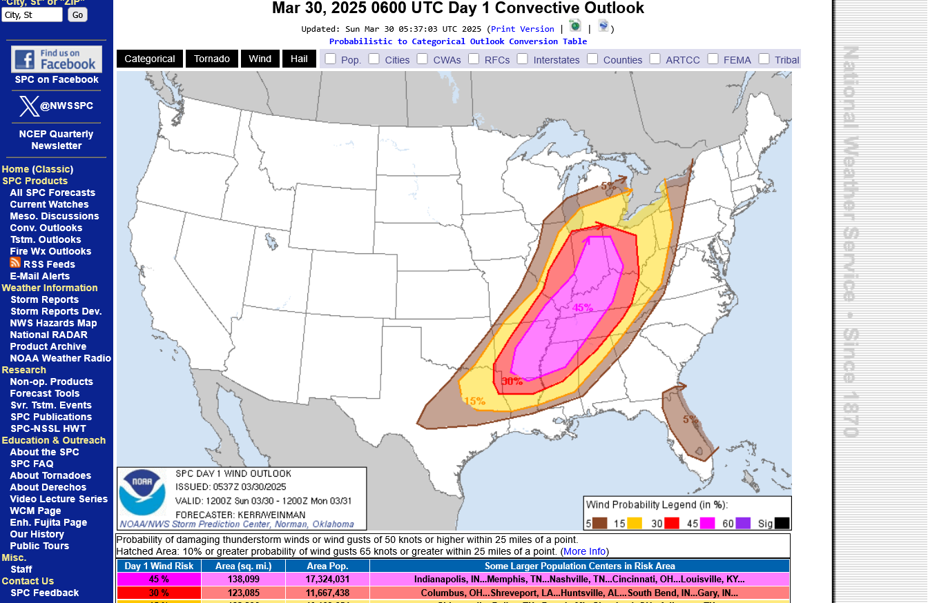
HIGH WIND RISK BELOW(the main risk):
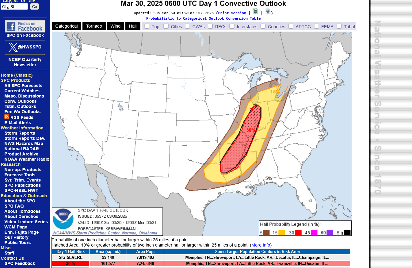
LARGE HAIL RISK BELOW:

+++++++++++++++++++++++
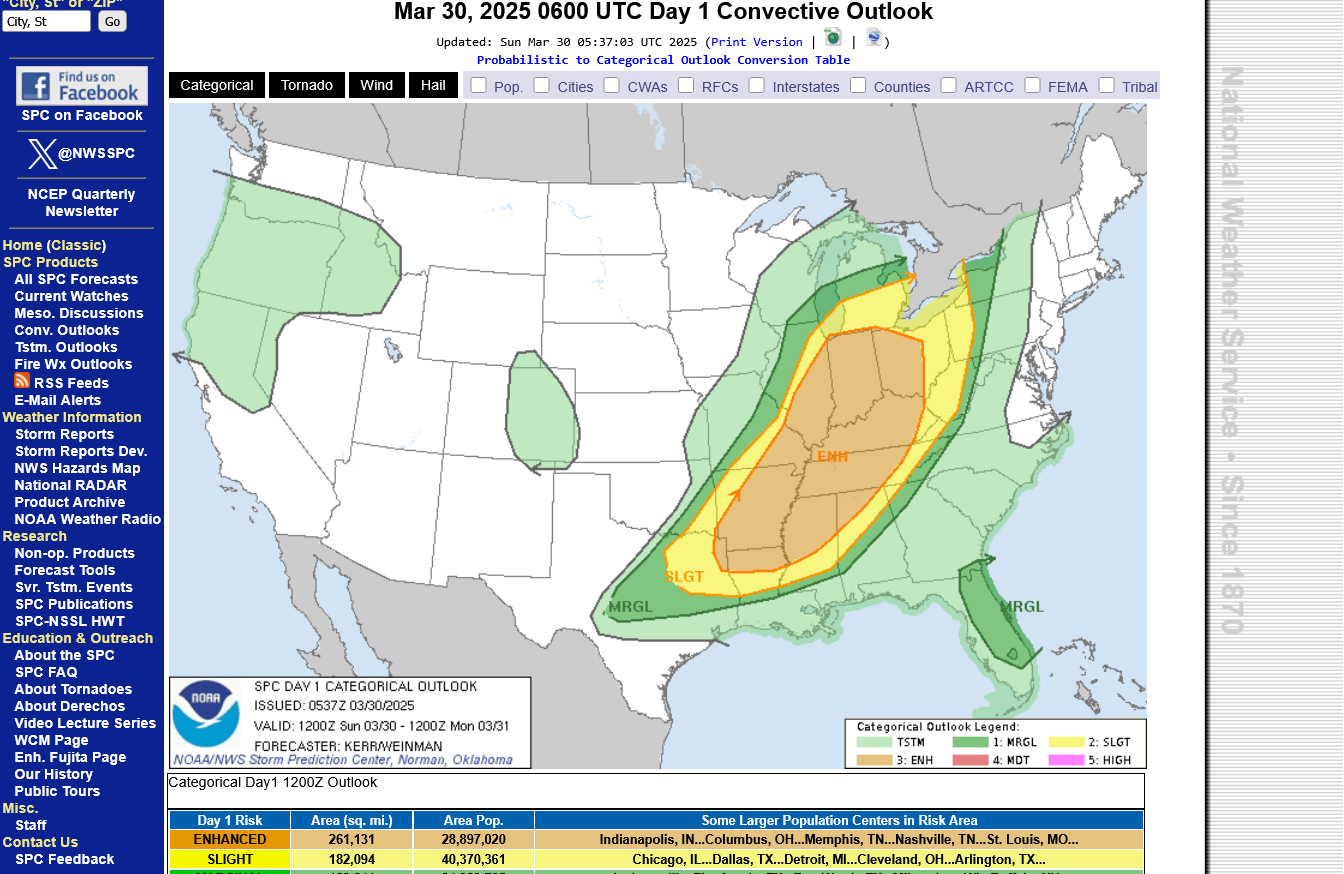
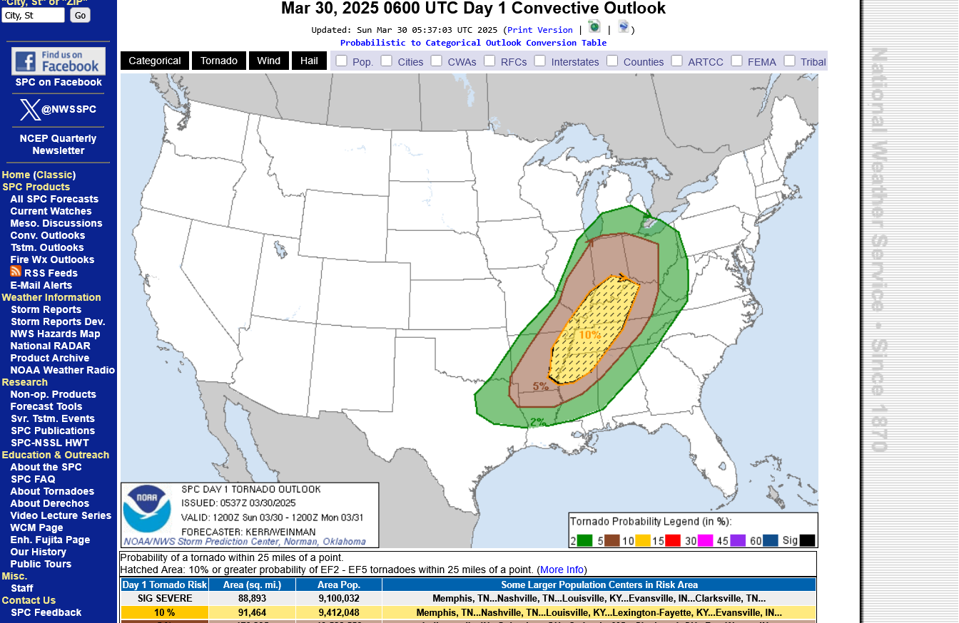
Sundays update DAMAGING WINDS ARE THE MAIN THREAT NOT VIOLENT TORNADOES. The jet stream is too weak for a violent tornado outbreak but weak tornadoes can still happen!
https://www.spc.noaa.gov/products/outlook/day1otlk.html
Overall risk is enhanced MAINLY FOR DAMAGING WINDS
+++++++++++++++++++++++
Mainly weak tornado risk =10%
+++++++++++++++++++++++++++
MUCH ELEVATED RISK OF DAMAGING WINDS =45%
+++++++++++++++++++++++++
ELEVATED RISK OF LARGE HAIL =30%
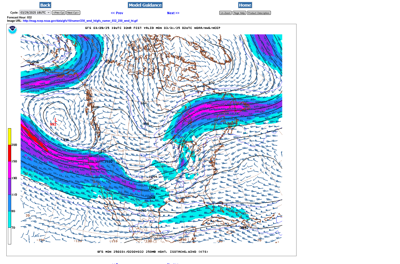
This is the 300 mb jet stream late Sunday, when the threat will be highest for southwestern IN.
We have a little jet streak approaching from the southwest which will help produce some decent lift and vertical shear) ahead of it. You can see the small cutoff low at this level in Kansas.
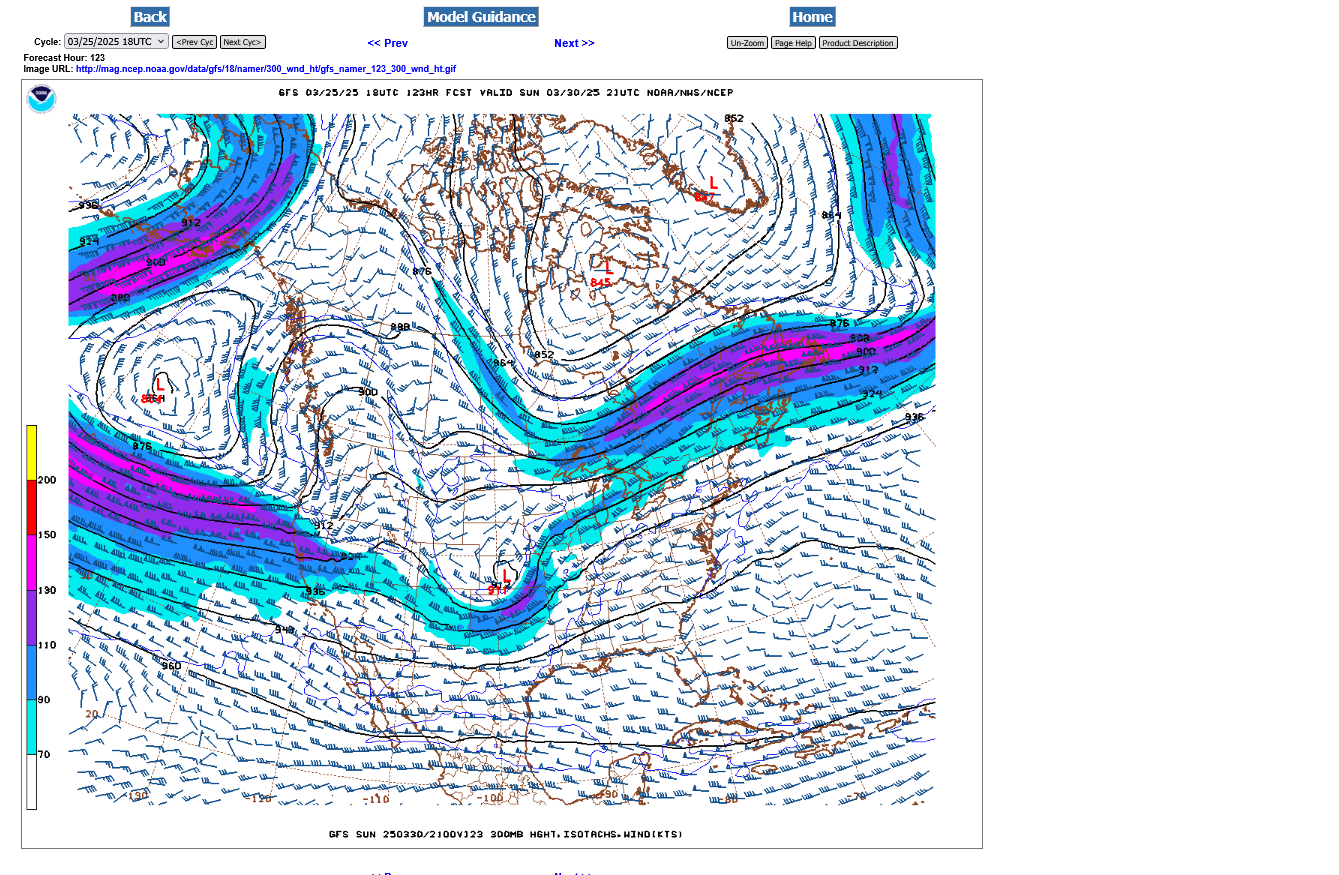
300 mb is around 30,000 feet up and close to where the commercial airline jets fly.
| Level | Standard Height | |
| 1000 MB | 364 ft | 111 m |
| 925 MB | 2498 ft | 762 m |
| 850 MB | 4781 ft | 1458 m |
| 700 MB | 9882 ft | 3013 m |
| 500 MB | 18289 ft | 5576 m |
| 400 MB | 23574 ft | 7187 m |
| 300MB | 30065 ft | 9166 m |
| 250 MB | 33999 ft | 10366 m |
| 200 MB | 38662 ft | 11787 m |
| [Boqueteweather.com] | ||
https://www.noaa.gov/jetstream/upper-air-charts/constant-pressure-charts-300-mb
++++++++++++++++++++++++
ASSESSING ATMOSPHERIC PRESSURES
AND HEIGHTS
http://www.theweatherprediction.com/habyhints/77/
JeffHaby
Select a tutorial below or scroll down...
+++++++++++++++
https://oceanservice.noaa.gov/facts/nautical-mile-knot.html
Nautical miles are used to measure the distance traveled through the water. A nautical mile is slightly longer than a mile on land, equaling 1.1508 land-measured (or statute) miles. The nautical mile is based on the Earth’s longitude and latitude coordinates, with one nautical mile equaling one minute of latitude.
+++++++++++++
https://www.maximum-inc.com/learning-center/what-is-knot-speed/
++++++++++++++++++
https://www.thoughtco.com/measuring-wind-speed-in-knots-3444011
| Unit of Measure | |
|---|---|
| Surface winds | mph |
| Tornadoes | mph |
| Hurricanes | kts (mph in public forecasts) |
| Station Plots (on weather maps) | kts |
| Marine forecasts | kts |
+++++++++++++++++++
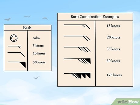
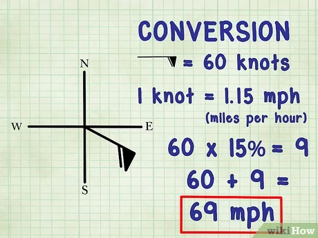
https://www.wikihow.com/Read-Wind-Barbs
Updated the front page too.
This one will NOT be as intense of a deep low surface pressure and an extreme pressure gradient like some of the previous storms the past month. However there may still be winds gusting close to 30 mph on Sunday.
Surface Weather maps for days 3-7 below:
https://www.wpc.ncep.noaa.gov/medr/medr.shtml

Updated at the top. There are 2 variations in the model outlook for this event.
Model 1: Clouds and rain in the higher risk, HATCHED areas below cap the risk at enhanced.
Model 2: More afternoon sunshine in those areas destabilizes the atmosphere, breaks the cap and causes a major outbreak that includes the potential for STRONG Tornadoes. Later today/early Sunday, it will be come more clear. If THIS model is looking more likely to verify, the outlook will upgrade and add an area of MODERATE, level 4 our of 5 risk.
This is the updated Day 2 outlook(tomorrow/Sunday). https://www.spc.noaa.gov/products/outlook/day2otlk.html
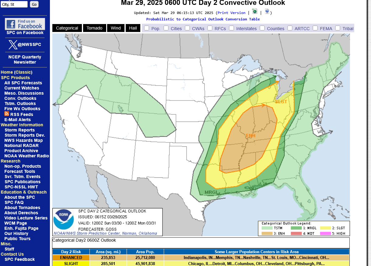
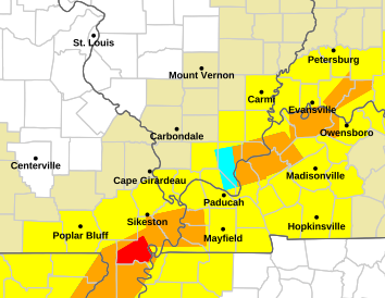
TORNADO RISK BELOW:

HIGH WIND RISK BELOW:

LARGE HAIL RISK BELOW:
I’m not that impressed with the dynamics for tomorrow, despite the enhanced outlook by the storm forecast center.
However, next Wednesday looks like an upper level pattern that’s favorable for a classic major outbreak that includes long track strong tornadoes.
I expect at least a moderate, level 4 out of 5 risk on Wednesday afternoon and possibly a 5, high risk area outlined by the storm prediction area, when we get closer. They won’t refine the risk area to include those higher risk categories until Monday when the outbreak moves up to day 3 in the forecast.
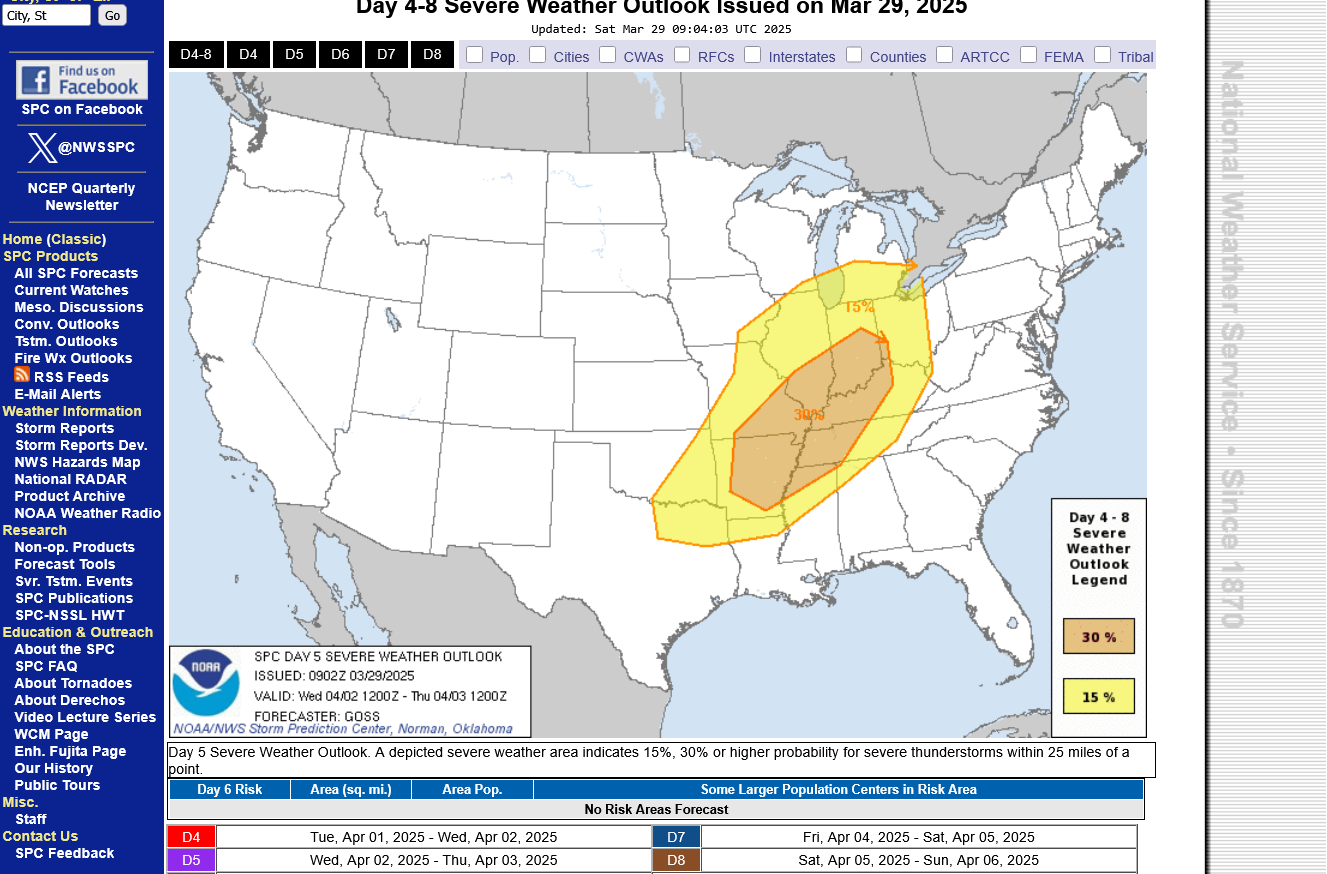
This is the day 5 Wednesday map below: 30% is the highest they go this far out. It will be the same tomorrow, then Monday they will add new higher risk categories since we will be on day 3.
https://www.spc.noaa.gov/products/exper/day4-8/#
+++++++++++++++
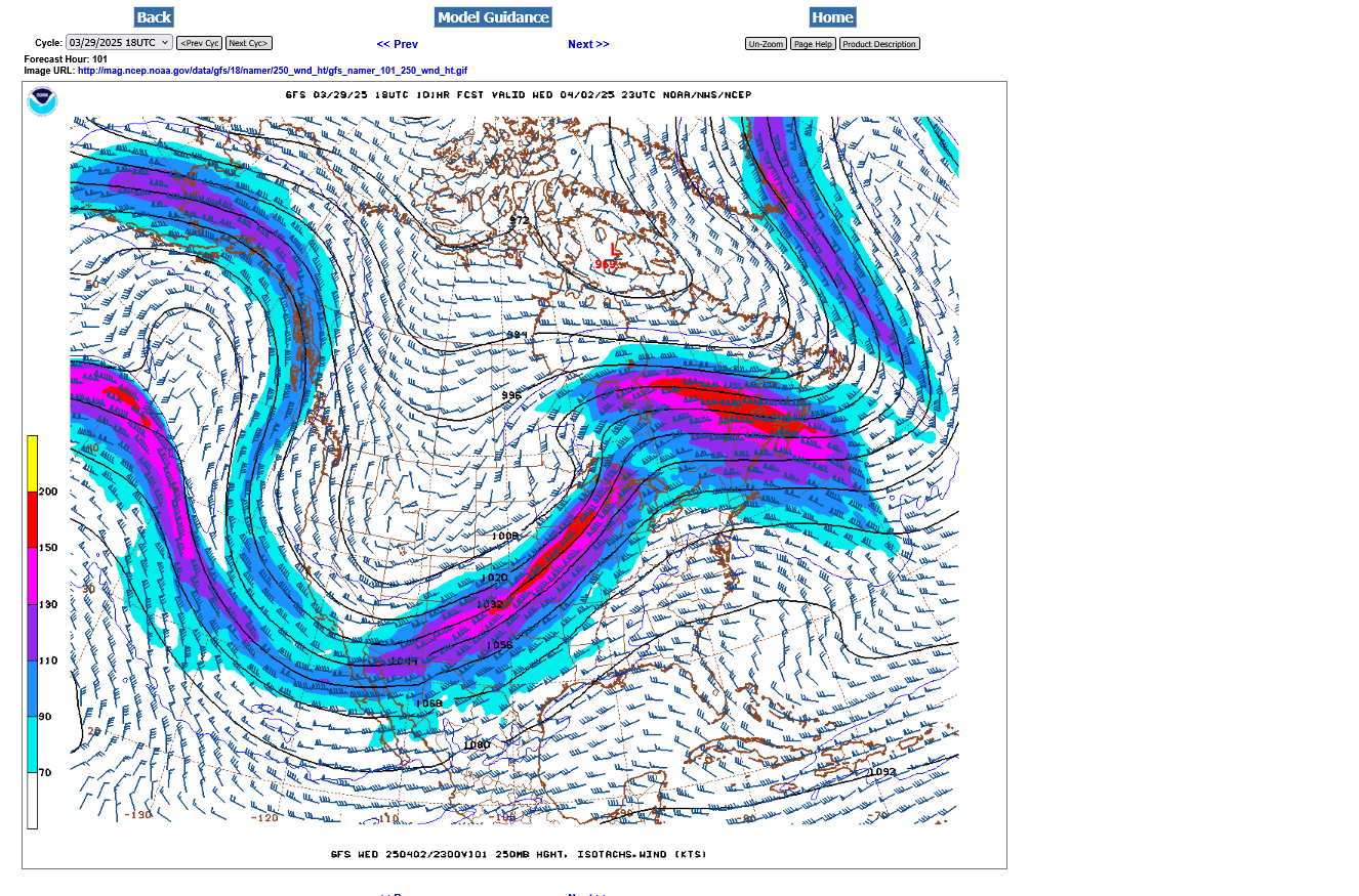
Look at the huge difference in the 250 mb jet stream between Sunday and Wednesday, below.
1. Late Sunday evening. Very tiny 125 mph jet streak embedded in weak jet stream. This is NOT a jet stream that typically creates the dynamics for severe weather outbreaks of violent tornadoes. Severe weather is possible Sunday but violent tornadoes are not likely. But look at whats ROARING out of the Pacific and hitting the West coast in 24 hours!!! That's the storm AFTER this next one.
2. 3 days later, late Wednesday, that same jet stream has tracked across the country, with an embedded ~200mph jet streak, tracking southwest to northeast on the front side of a deep upper level trough. Underneath and to the right of that jet stream is where the mostlviolent severe storms and tornadoes will be. The timing for highest risk looks like very late Wednesday evening. It's still 4 days away and that timing will change. However, a jet stream this strong over such a large area is NOT going away. Details will change as we get closer but there WILL be a severe storm outbreak on Wednesday. Not might be but WILL be. Stay tuned for details as we get closer.

2. Late Wednesday below. Classic, very powerful upper level jet stream for violent storms and tornadoes.
Early thoughts are that the violent weather ahead of an approaching cold front may start impacting western Indiana VERY LATE on Wednesday evening.
This is the surface map for Wednesday, just after Noon. You can see the packed isobars for the tight pressure gradient. Winds will likely be gusting above 40 mph. Peak wind gusts on Sunday may stay under 30 mph.
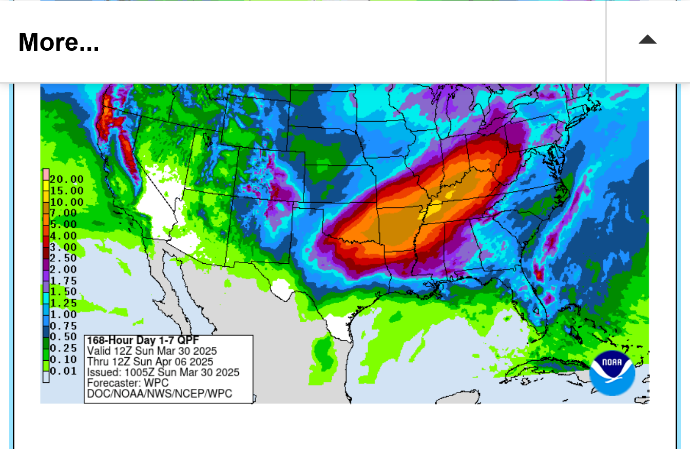
It's going to be an extremely WET week too.
https://www.marketforum.com/forum/topic/83844/#83848
++++++++++++++++++
Frozen frame image:
Constantly updated image:
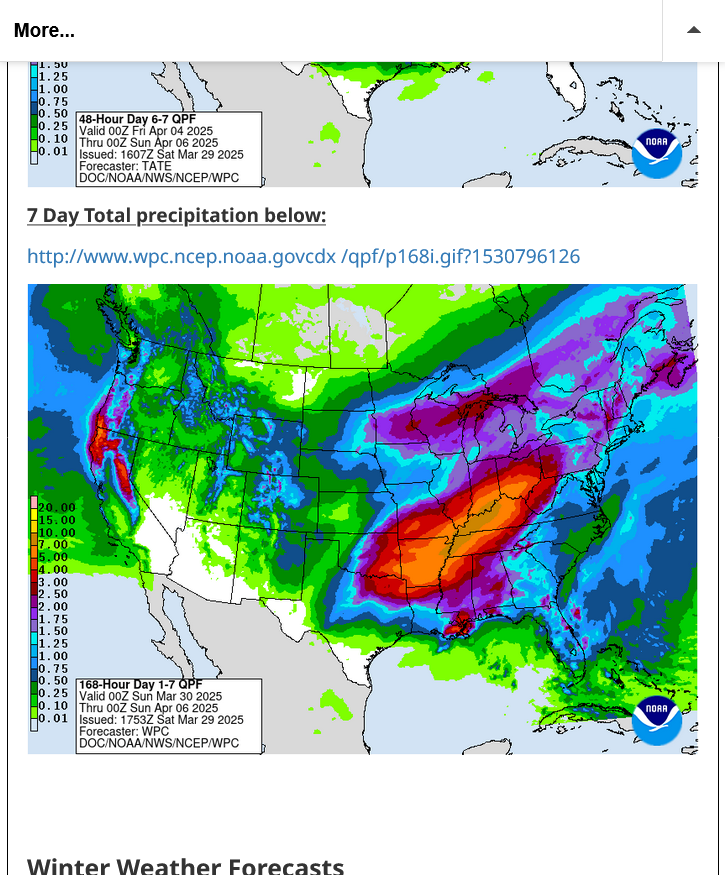
7 Day Total precipitation below:
http://www.wpc.ncep.noaa.govcdx /qpf/p168i.gif?1530796126

Rough weather week coming up. Late today will bring a slight/enhanced (level 2/3) severe weather risk.
Wednesday is the severe storm tornado outbreak with at least a level 4 out of 5 moderate risk, possibly 5 (high risk).
It's still just day 4 and the highest risk the Storm Prediction Center will go is 30% until day 3, when they delineate more. Expect at least a moderate risk on Monday's map.
https://www.spc.noaa.gov/products/exper/day4-8/#
+++++++++++++++++++++++++++
The 7 day rainfall update has actually ADDED more rain, which could amount to close to 10 inches this week.
Let's start with the latest 7 day rain forecast:
https://www.marketforum.com/forum/topic/83844/#83848
Freeze frame forecast: The brown is 7+ inches. The yellow is 10+ inches. Thursday looks the wettest with several inches+ likely just that day but more could come after that.
Constantly updated maps:
https://www.marketforum.com/forum/topic/83844/#83848
Sunday's risks updated on page 1 at the top:
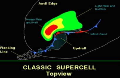
Wednesday's tornado outbreak is likely to come from Supercell Thunderstorms:
https://www.weather.gov/ama/supercell
Tornado watch until 7pm! At least this one won't keep us up until after 3am like the last one did for some of us
Current Hazards at the link below.
For your NWS and county, go to the link below.
Then you can hit any spot on the map, including where you live and it will go to that NWS with all the comprehensive local weather information for that/your county.

New radar product below
Go to: "Select View" then "Local Radar"
Hit the purple circle to see that local radar site
+++++++++++++++++++++++
This link below provides some great data. After going to the link, hit "Mesoanalysis" then, the center of any box for the area that you want, then go to observation on the far left, then surface observations to get constantly updated surface observations or hit another of the dozens of choices.
 |
https://www.wunderground.com/maps/radar/current

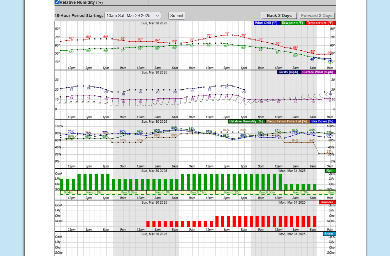
SOME Clouds and rain ahead of this storm are GOOD NEWS! They are suppressing the buoyancy/instability of the air mass which increases in magnitude from rising temperatures. No sun =Good!
There are breaks in the clouds that will cause a bit of heating. The 1pm temperature was 72 Deg. F. A full sun would take us to 80+
You can see the well defined cold front (kink in the isobars) and sharp wind shift line behind it (from south to west).
LOWER MIDWEST
https://www.spc.noaa.gov/exper/mesoanalysis/new/viewsector.php?sector=20

https://www.spc.noaa.gov/exper/mesoanalysis/new/viewsector.php?sector=20#

https://www.spc.noaa.gov/exper/mesoanalysis/new/viewsector.php?sector=20# 
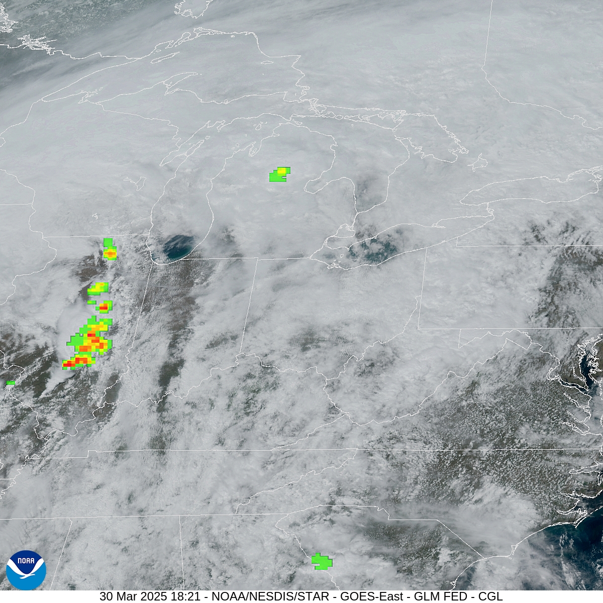
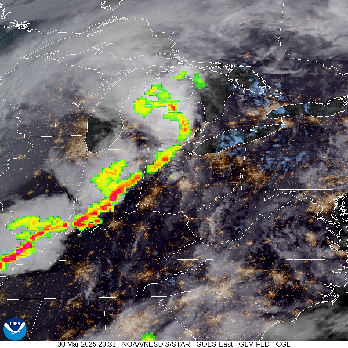
This is a new product I just found. Pretty cool satellite loop with colorized high topped storms.
Latest loop at this link. Lots of clouds but with a few breaks.
https://www.star.nesdis.noaa.gov/GOES/sector_band.php?sat=G16§or=cgl&band=EXTENT3&length=24
Freeze frame at 1:21 CDT below.
Freeze frame at 6:30pm
Local NWS:
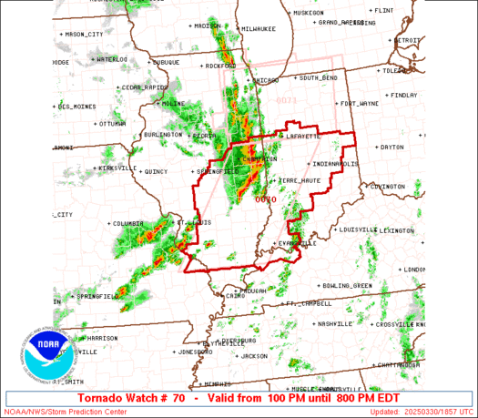
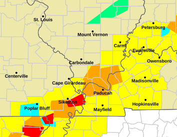
Tornado watch in yellow until 7pm
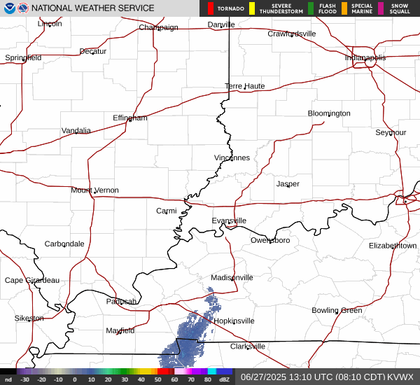
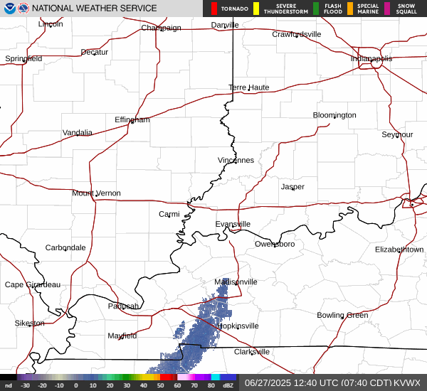
Evansville Radar below:
Local radar Super Resolution Base Reflectivity


Paducah radar below:

Storm Prediction Center-get more info by going to these links

https://www.spc.noaa.gov/products/watch/ww0070.html
Tornado Watch 70 hit the dark blue boxes for more information
| < Previous WW Next WW > |
|
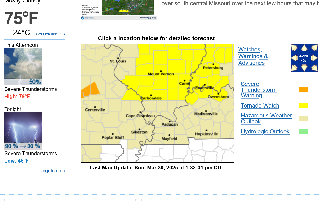
3:30pm watch/warnings. All for SEVERE THUNDERSTORMS. The main risk with this event is damaging winds NOT tornadoes. However, a tornado could happen too and the Storm Prediction Center just stated that it could be a strong tornado(130 mph-ish??). Not likely to be the violent kind of tornado that kills people but please go to your safe place if a warning is issue for best protection from the worst case scenario.
Evansville Radar below:
Local radar Super Resolution Base Reflectivity
3:33pm-First tornado warning of the day, Richland/Clay IL county for radar indicated rotation.
The clouds broke up earlier and sunshine has bumped the temperature us to 77 and going up.
That INCREASES the instability a bit, which will make the storms stronger. Looks like ETA for Evansville is approaching 7pm-ish.
This was almost an hour ago. I was busy typing/sending chess emails to our 5 schools.
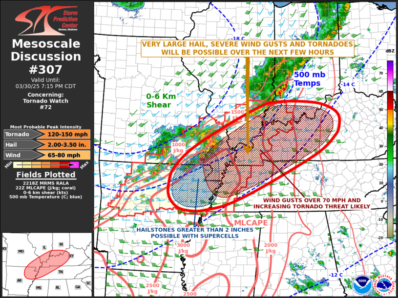
https://www.spc.noaa.gov/products/md/md0304.html
Get the latest mesoscale updates here:
https://www.spc.noaa.gov/products/md/
Coming your way, later this evening cutworm(southeast IN)!
Storms about to hit here. Scroll up to see the live radar image.
Just severe thunderstorm warnings so far in our area. No tornadoes no major outbreak.
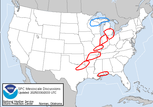
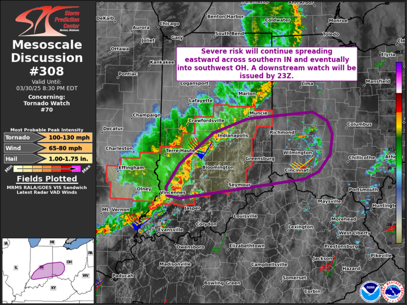
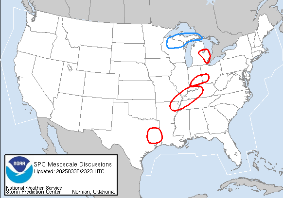
https://www.spc.noaa.gov/products/md/md0308.html
+++++++++++
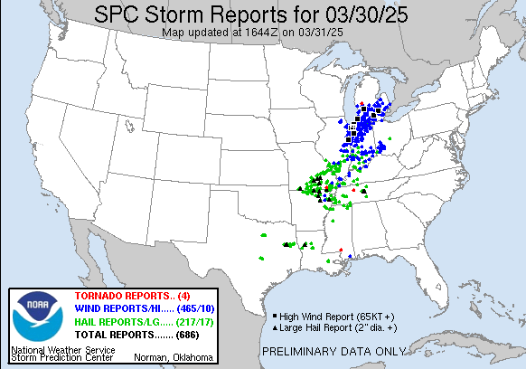
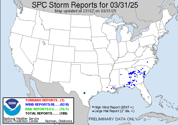
1. 154 damaging wind reports, mostly on the northern part of the line of storms
2. 90 large hail reports-mostly on the southern half of the line of storms
3. 2 weak tornado reports
https://www.spc.noaa.gov/climo/reports/today.gif
The jet stream is too weak to cause an outbreak of strong tornadoes!
Isolated tornadoes? Yes.
We can never rule out a strong one either with a potent system like this.
Far northeast Vanderburgh County just got a severe thunderstorm warning, with our sirens going off. These storms with the warning actually developed AHEAD of the main line.
The main line of storms is still to our west.
Just stay indoors and away from windows and you'll be fine.
Local radar Super Resolution Base Reflectivity
6:20pm: Were getting a few tornado warnings to our SOUTHWEST in the main line of storms, which still looks like they will get here in the 7pm+ time frame.
Highest risk for a tornado will be SOUTH of Evansville but the storms have turned tornadic along the MO/IL/KY border area. That can't be ruled out here, even with the higher threat south of Evansville.
This went out almost an hour ago and I hadn't checked that link until just now. The HIGHEST risk for a tornado will be just south of us but we are in the tornado risk zone according to the experts.
They list the potential tornado winds at 120-150 which is getting up there, so although we've had higher risk dynamics with weather systems and I'm not that impressed, when the Storm Prediction Center makes a statement like that, we should always take it seriously.
https://www.spc.noaa.gov/products/md/md0307.html
https://www.spc.noaa.gov/products/md/
6:50pm: The storms to our west have weakened a bit and none of them headed towards Evansville are severe.(at the moment).
ETA is closer to 7:10-7:30pm-ish.
These are the latest warnings as of 6:53pm. It the southern part of the line that packs the most punch.
7:17 pm:
Severe t-storm warning to our east. A bigger one to our southwest. OK we just got one this second...sirens going off.
You can see from the updated map below that the warning was for extreme southern Vanderburgh county. The sirens go off EVERYWHERE in the county if any part of it is in the warning.
We just got some small hail but THE SEVERE WEATHER THREAT IS OVER IN EVANSVILLE UNTIL LATE WEDNESDAY:
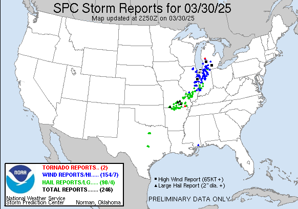
So far:
1. 2 tornadoes
2. 212 damaging wind reports. Black squares at winds of 75+ mph.
3. 117 hail reports. Black triangles are LARGE hail of 2"+ diameter.
4. Not much in our area other than some hail just east of Evansville. We got a bit of small hail around 7:20pm or so.
https://www.spc.noaa.gov/climo/reports/today.gif

Track the storms and all the weather the rest of the night here:
https://www.marketforum.com/forum/topic/83844/
This is where the storm risk will be on Monday:
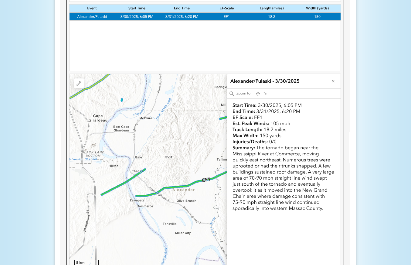
lost my internet connection we were under tornado warning radar indicated 40 miles w x sw of me at 7:45ish EDT Friend of the wife's said it took off a roof on one house there.
Nothing much here
Over 500’ reports of the high winds so far For the country the last 12 hours.
3 weak tornadoes. When the NWS surveys the damage this week they should find that some of the damage was caused by a weak 9otornado or 2 that they thought was a severe storm ind. Hard to tell in the dark!
This was the final preliminary number for 24 hour storm reports thru 7am this morning.
When the NWS does surveys of damage, these numbers will change a bit. They could add a few tornadoes after inspecting the damage pattern.
https://www.spc.noaa.gov/climo/reports/yesterday.gif
+++++++++++++++++++++++++++
You can see above that almost all the high wind reports were north of Evansville and some east. This was 100% from the jet streak below on the 250 mb map from yesterday evening seen below. That little feature in purple, a jet streak/max focused a fairly compact lifting agent on the atmosphere below it, despite the lower temps/dew points that far north.
Farther to the south, the atmosphere was primed for large hail. There was more convective potential from higher moisture/temps, with high moisture soundings and water loading, along with some colder air aloft/low freezing level.
http://www.usawx.com/hail_threat_on_soundings.htm
Weak jet stream by severe weather outbreak standards!
That will not be the case on Wednesday!!
+++++++++++++++++
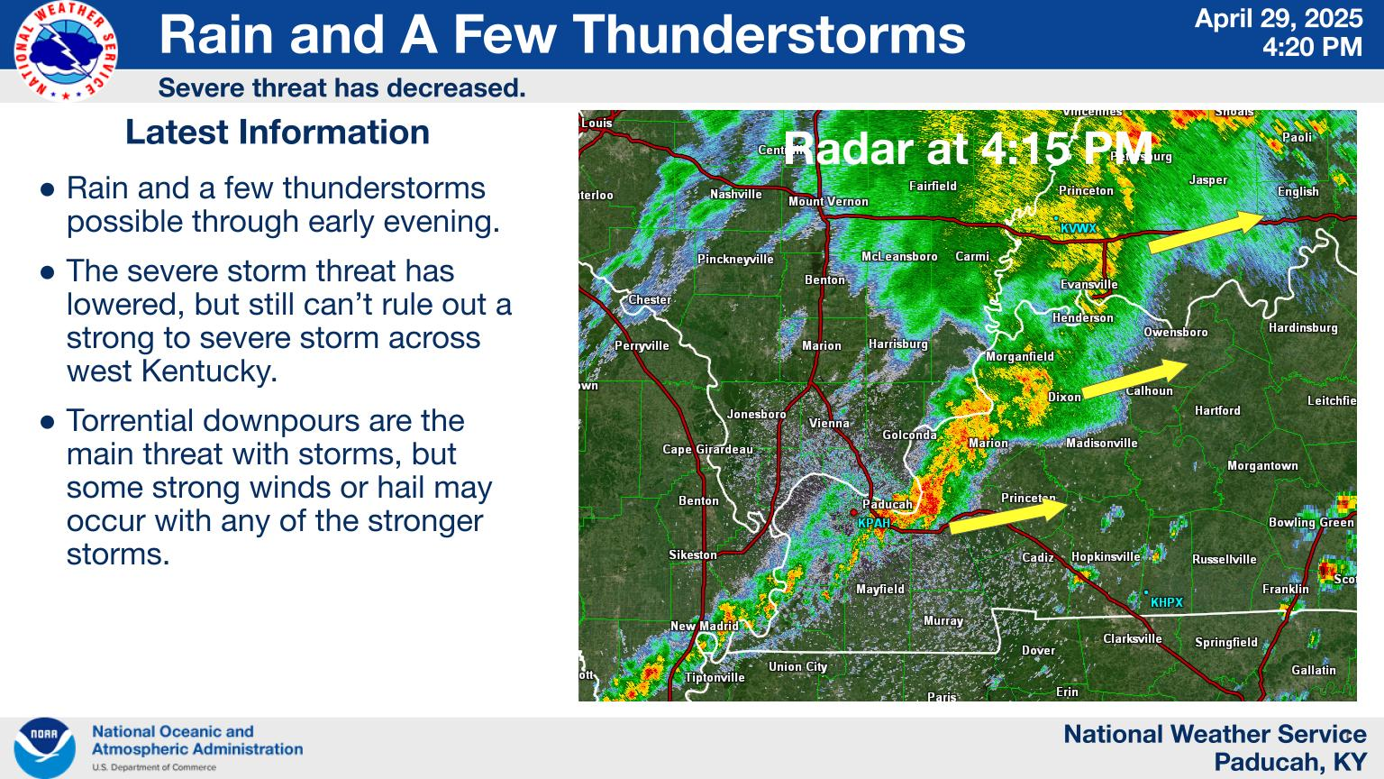
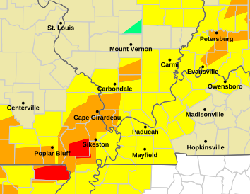
https://www.weather.gov/pah/2025March30Severe
+++++++++++++
The map they're showing appears to be misleading. Looks like it has all the tornadoes from the last year or longer. The only tornado, a weak one in the Paducah area was in Arkansas and described below.
The storms continued southeast today to Larry-land(Atlanta)
https://www.spc.noaa.gov/climo/reports/today.gif

 Weather Map