
We are currently busy covering Sunday's severe storms.
3-25-25 Severe weather for 3-30-25
https://www.marketforum.com/forum/topic/110671/
++++++++++++++
This will be the main thread after that threat passes because the threat is MUCH higher on Wednesday, along with the excessive rain coming up Wed-Sun.
Get all the constantly updated weather here:
https://www.marketforum.com/forum/topic/83844/
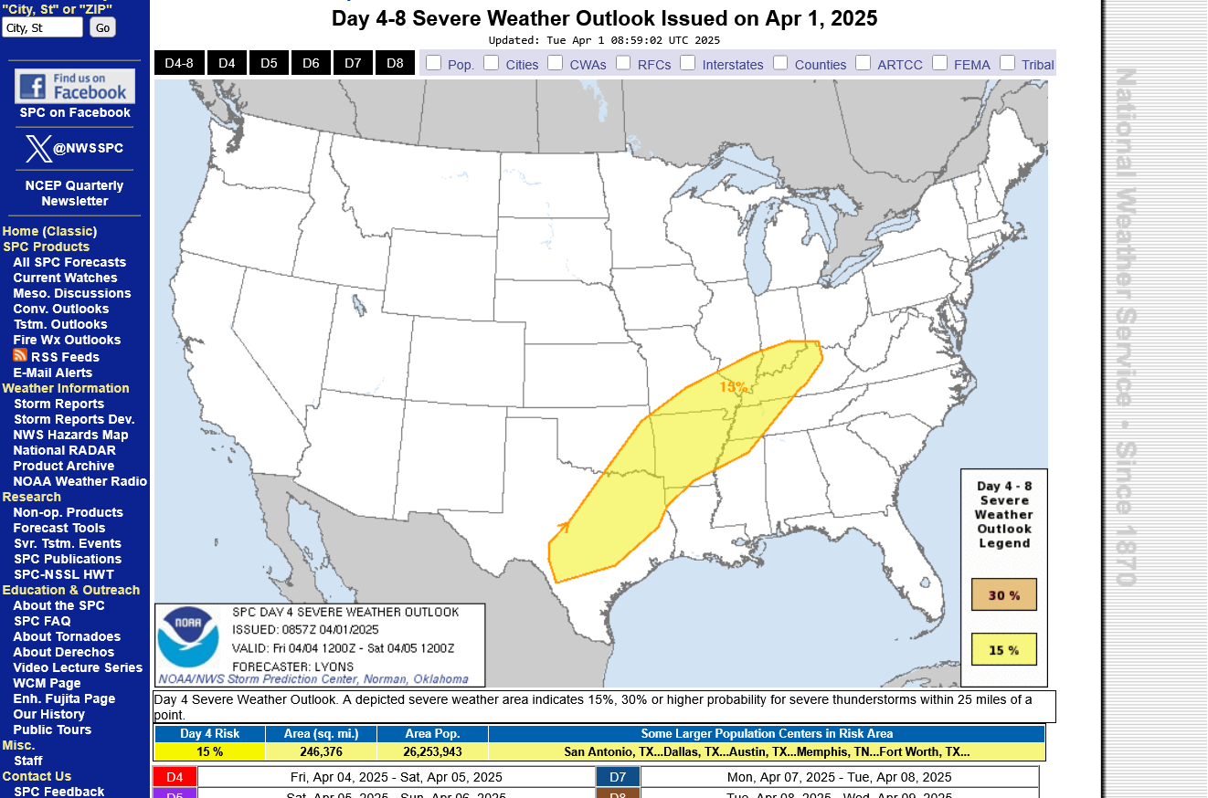
3-25-25 Severe weather outlook for 3-30-25
By metmike - March 30, 2025, 12:20 a.m.
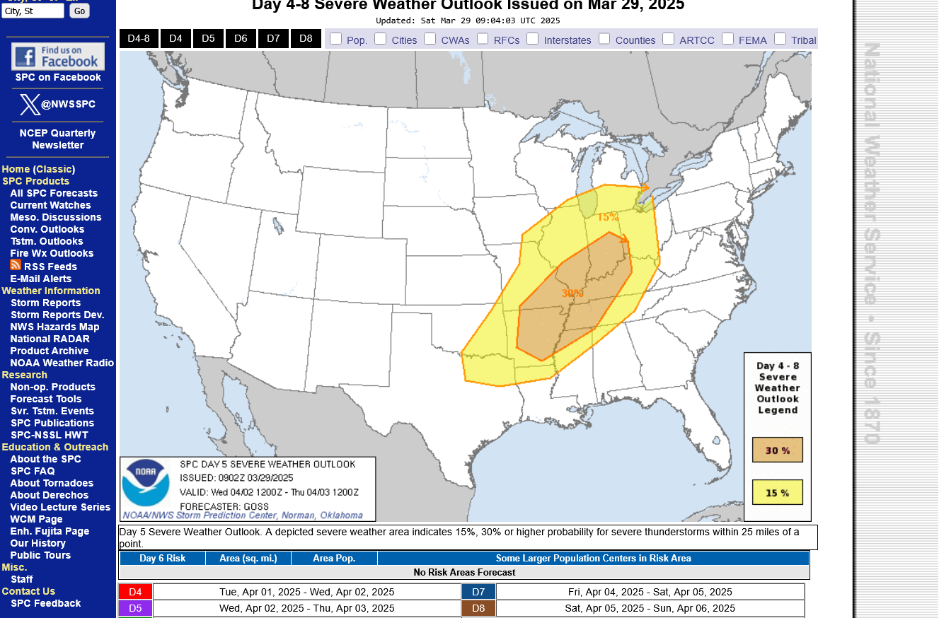
This was the day 5 Wednesday map yesterday: 30% is the highest they go this far out. It will be the same tomorrow, then Monday they will add new higher risk categories since we will be on day 3.
https://www.spc.noaa.gov/products/exper/day4-8/#
+++++++++++++++
Re: Re: 3-25-25 Severe weather outlook for 3-30-25
By metmike - March 30, 2025, 8:28 a.m.
Rough weather week coming up. Late today will bring a slight/enhanced (level 2/3) severe weather risk.
Wednesday is the severe storm tornado outbreak with at least a level 4 out of 5 moderate risk, possibly 5 (high risk).
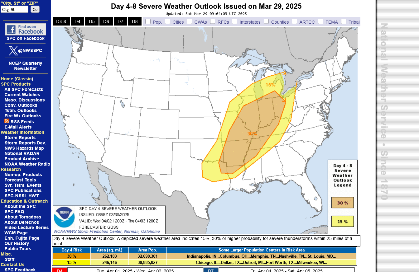
It's still just day 4 and the highest risk the Storm Prediction Center will go is 30% until day 3, when they delineate more. Expect at least a moderate risk on Monday's map.
https://www.spc.noaa.gov/products/exper/day4-8/#
+++++++++++
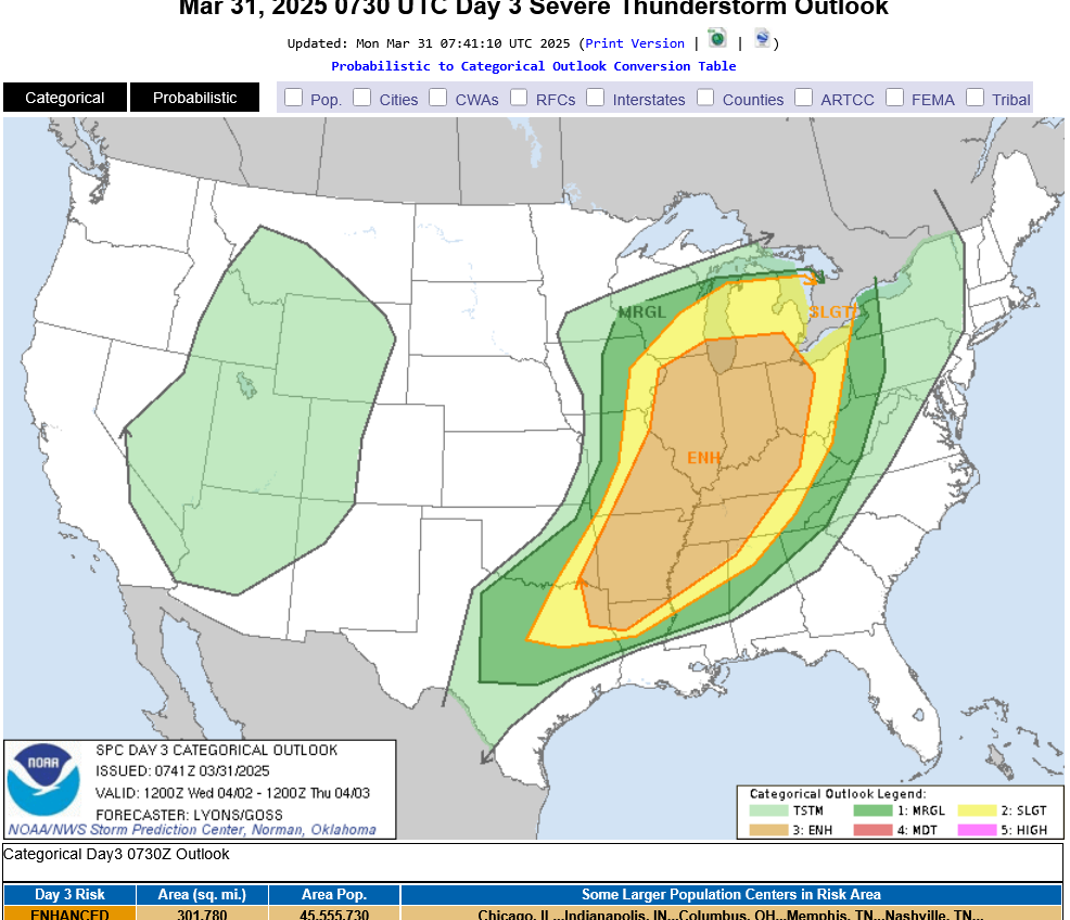
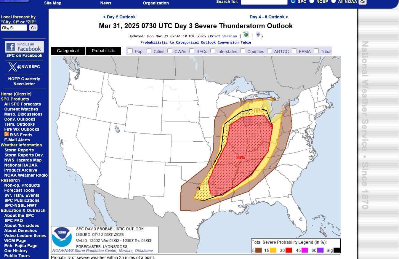
This was the day 3 update for Wednesday's outbreak. I feel confident they will have a moderate risk, 4 out of 5 level area by tomorrow. Enhanced is level 3 out of 5 and slight is level 1.
:https://www.marketforum.com/forum/topic/110789/#110790
This was the day 2 update, here on Tuesday. I'm surprised they have not added the moderate, level 4 category yet but probably tomorrow they will when we see everything coming together...........which has already started!
https://www.spc.noaa.gov/products/outlook/
+++++++++++++++++++++++
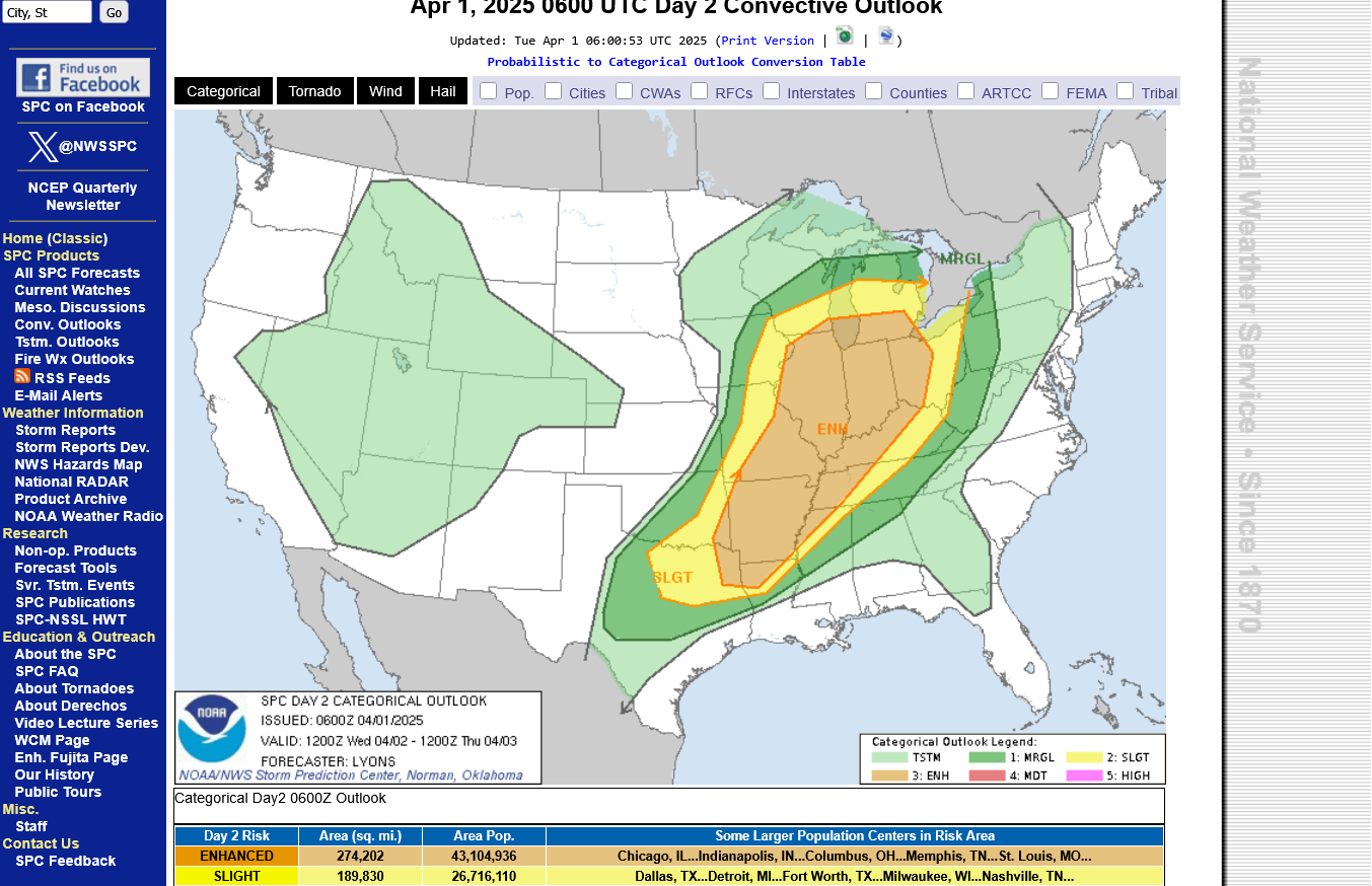
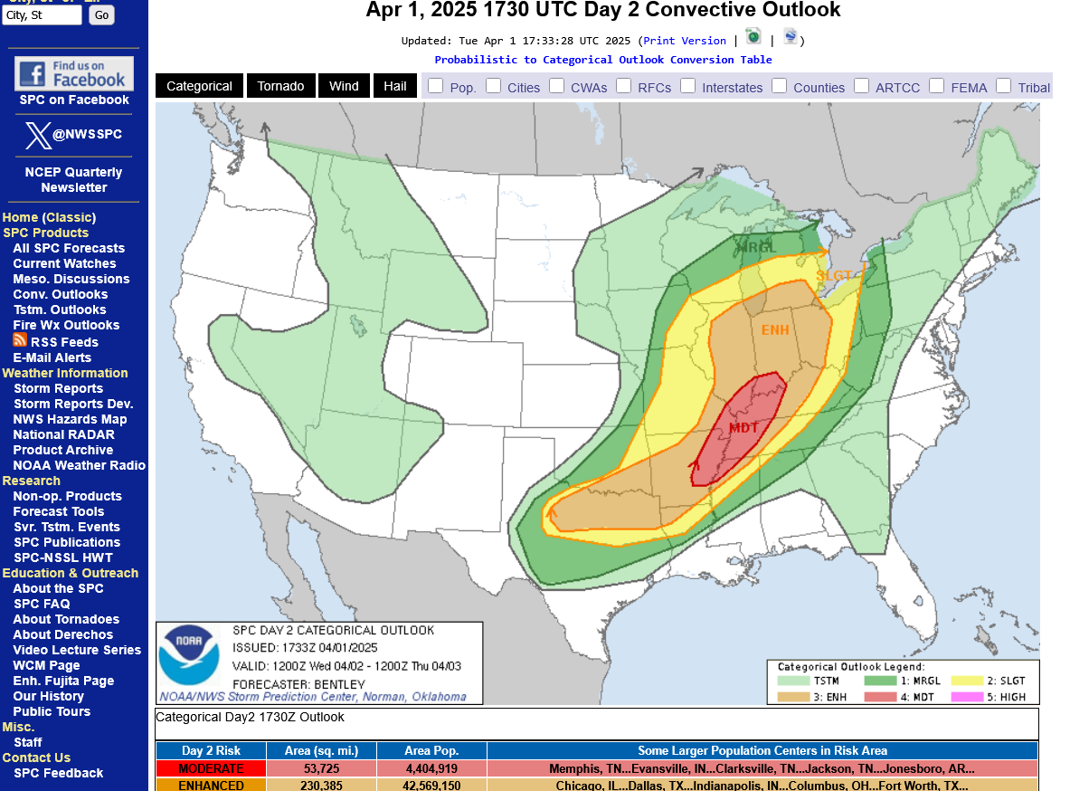
Day 2 afternoon update. They finally decided on where to put the moderate, level 4 risk area which includes Evansville.

++++++++++++++++++++++
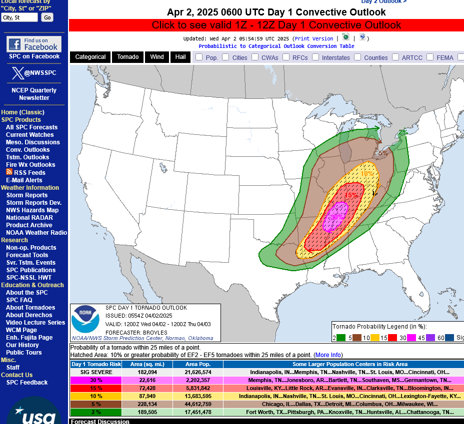
Tornado risk below = 15% for a tornado within 25 miles of any point. Violent, long track tornadoes possible on Wednesday. It's this high end tornado risk that justifies the moderate, level 4 overall risk.
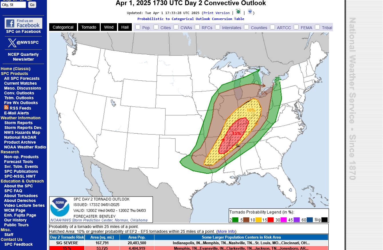
+++++++++++++++++++++++++++++++++++
Severe Thunderstorm winds =30% chance within 25 miles of any point on Wednesday.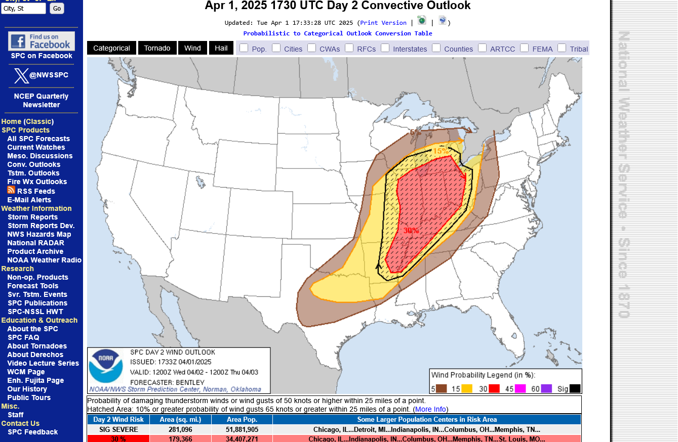
+++++++++++++++++++++
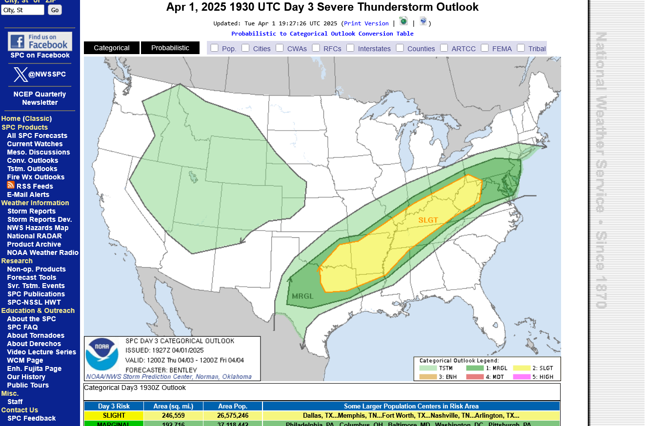
The risk for severe weather will continue Thursday and Friday but drop down to a slight, level 2 risk. The biggest problem after Wednesday will be excessive rains.
Thursdays risk:
++++++++++
Friday's risk:
++++++++++++++++++++
https://www.spc.noaa.gov/products/outlook/
As expected, the Storm Prediction Center is adding higher risk categories as we get closer to the main event. A couple hours ago, they updated their day 1 map and added a HIGH risk, inside the MODERATE risk they added Tuesday afternoon. This doesn't mean the storm is developing stronger than expected, it just means the Storm Prediction Center waited to be sure of the HIGH risk areas because assigning that level 5 out of 5 risk is pretty rare and people in a HIGH risk area need to be ready to go to a safe place HOURS before any tornado warnings are issued.
The dynamics from this storm are such that EF3+ tornadoes are possible. This means winds of 136 mph or more. Even a 200 mph tornado is possible. 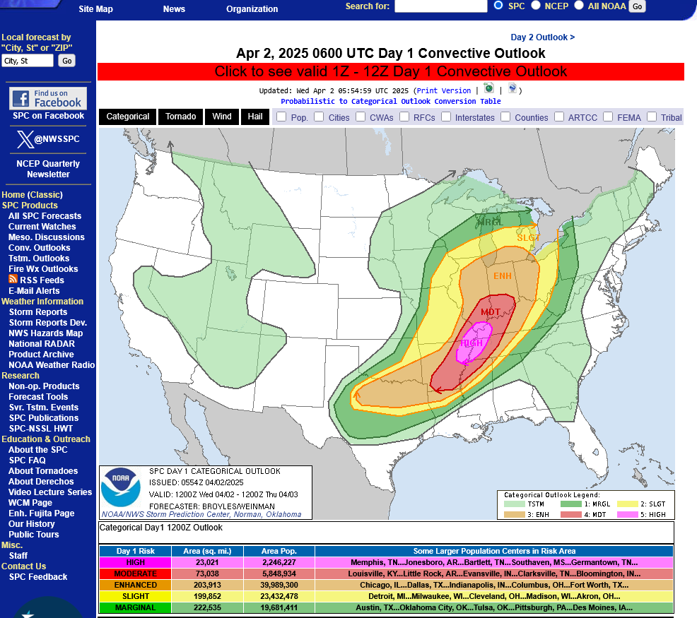
TORNADO RISK BELOW: 30% IN THE HIGH RISK. EVANSVILLE ~25% chance of a tornado within 25 miles of any location.

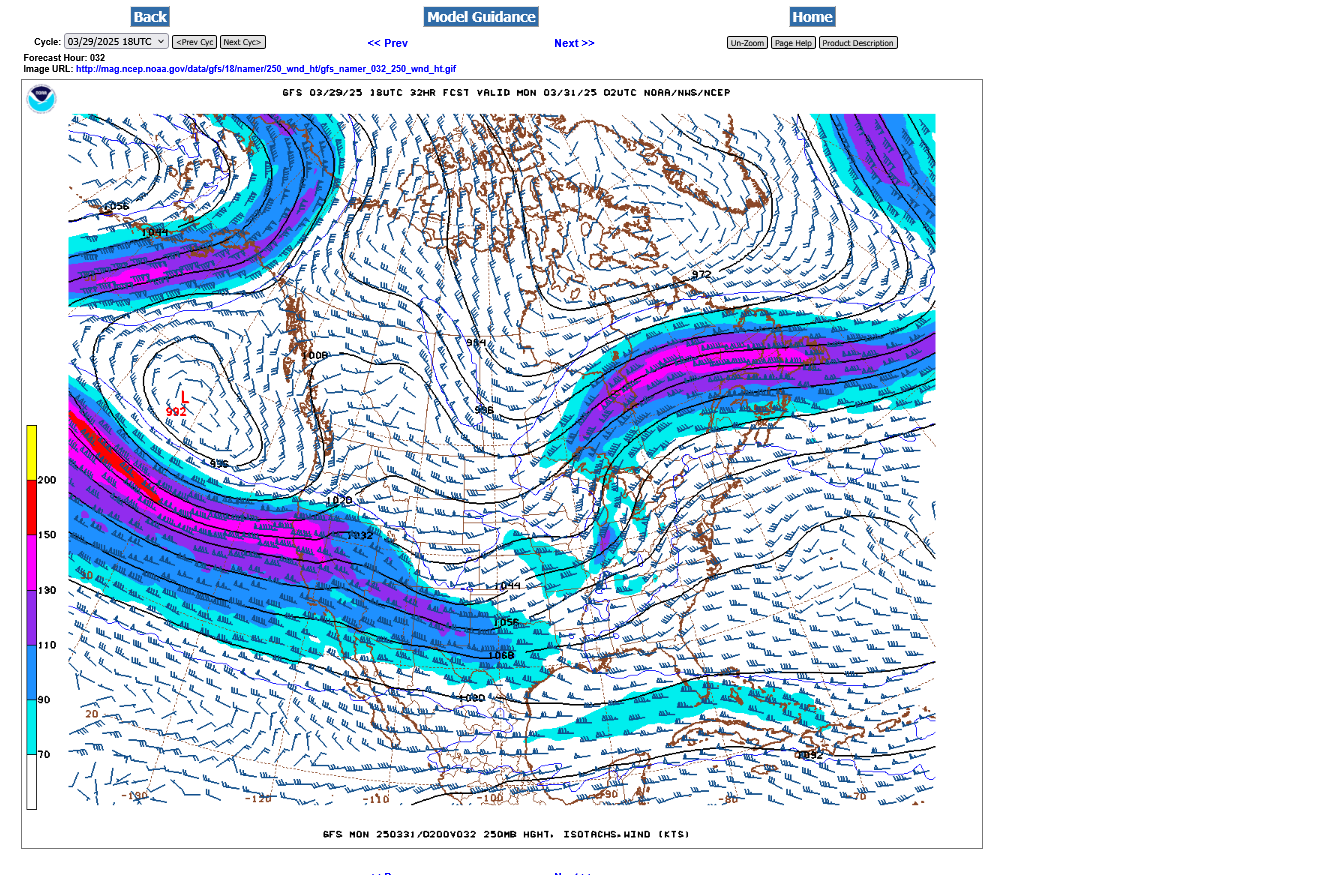
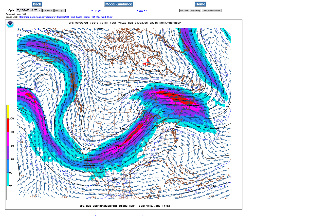
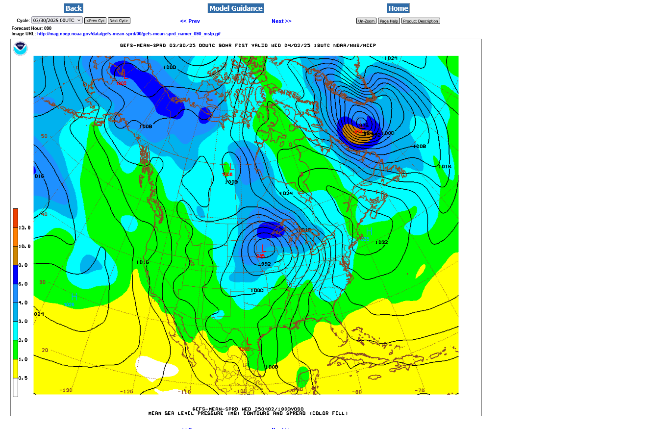
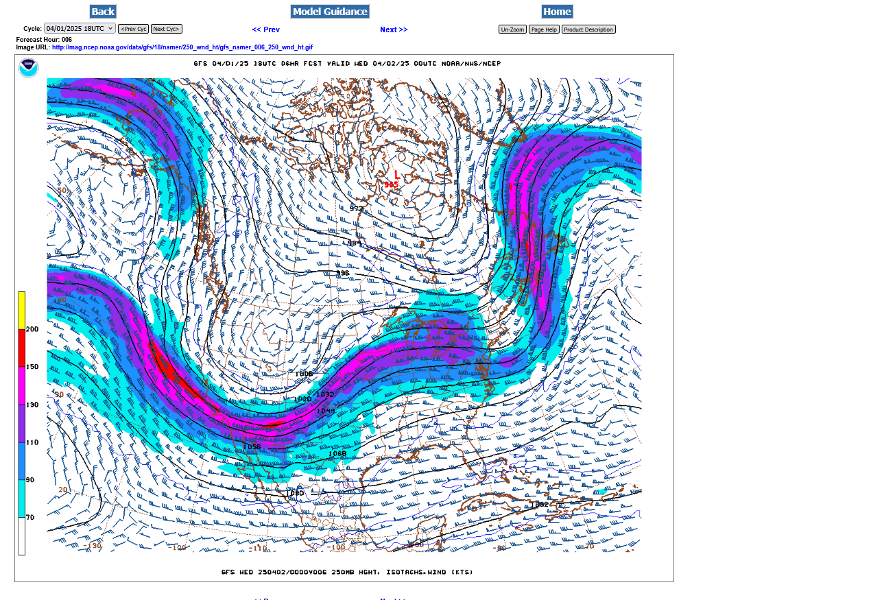
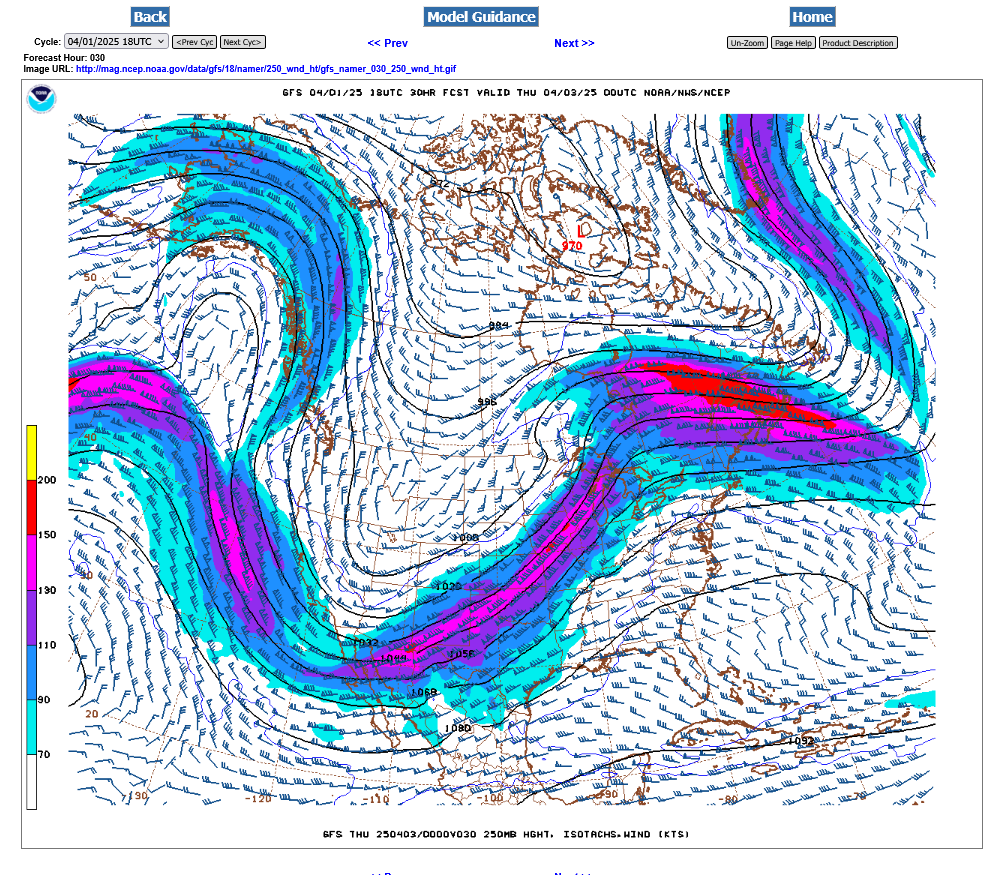
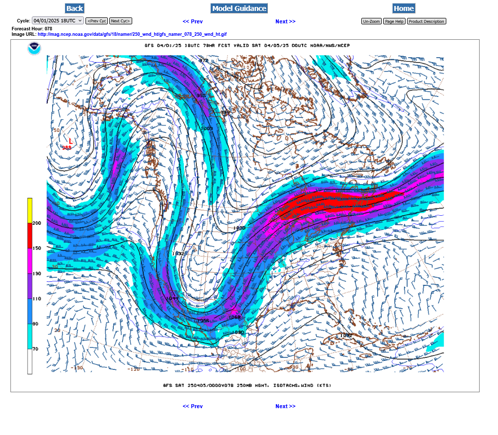
Look at the huge difference in the 250 mb jet stream between Sunday and Wednesday, below.
1. Late Sunday evening. Very tiny 125 mph jet streak embedded in weak jet stream. This is NOT a jet stream that typically creates the dynamics for severe weather outbreaks of violent tornadoes. Severe weather is possible Sunday but violent tornadoes are not likely. But look at whats ROARING out of the Pacific and hitting the West coast in 24 hours!!! That's the storm AFTER this next one.
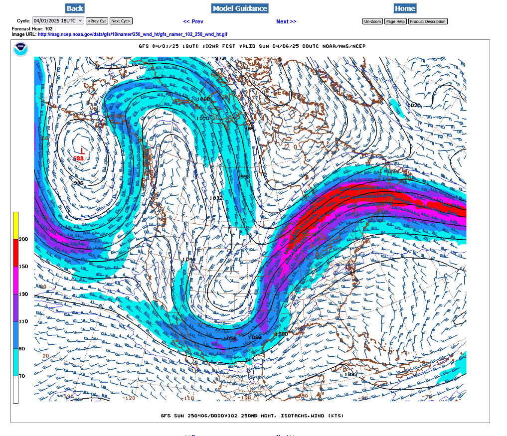
2. 3 days later, late Wednesday, that same jet stream has tracked across the country, with an embedded ~200mph jet streak, tracking southwest to northeast on the front side of a deep upper level trough. Underneath and to the right of that jet stream is where the mostlviolent severe storms and tornadoes will be. The timing for highest risk looks like very late Wednesday evening. It's still 4 days away and that timing will change. However, a jet stream this strong over such a large area is NOT going away. Details will change as we get closer but there WILL be a severe storm outbreak on Wednesday. Not might be but WILL be. Stay tuned for details as we get closer.
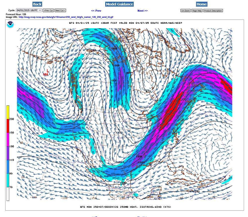
2. Late Wednesday below. Classic, very powerful upper level jet stream for violent storms and tornadoes.
Early thoughts are that the violent weather ahead of an approaching cold front may start impacting western Indiana VERY LATE on Wednesday evening.
This is the surface map for Wednesday, just after Noon. You can see the packed isobars for the tight pressure gradient. Winds will likely be gusting above 40 mph. Peak wind gusts on Sunday may stay under 30 mph.
The storm prediction center has just gone with a huge ENHANCED, level 3 risk area for Wednesday.
No MODERATE, level 4 risk yet because they are uncertain on exactly where to locate that moderate risk. I feel confident, that considering the strength of both the upper level and lower level jet streams that a moderate risk will be assigned to a significant region inside the enhanced risk.
See this update on page 2
:https://www.marketforum.com/forum/topic/110789/#110790


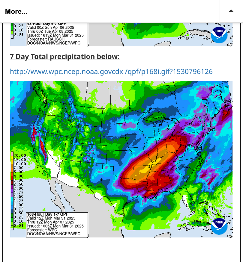
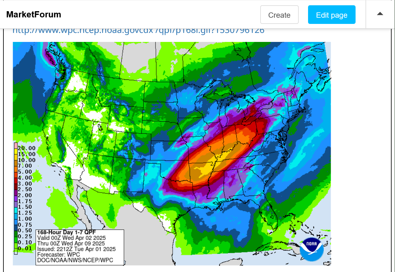
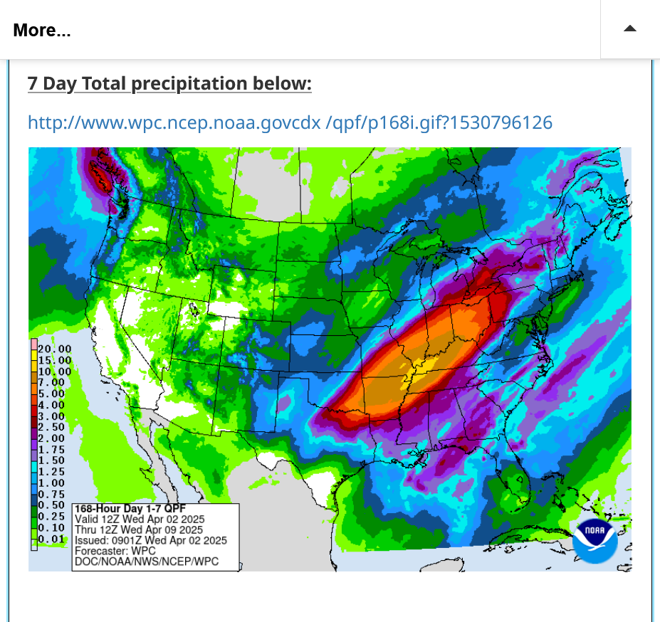
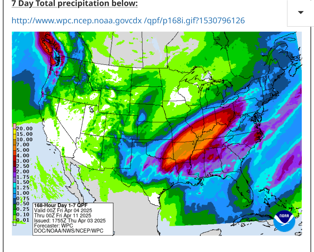
A total of almost 10 inches of additional rain(yellow shade) are possible the next week!!!
https://www.marketforum.com/forum/topic/83844/#83848
The green shaded area below is an unprecedented flash flood watch with regards to the length of time.
It extends for over 4 days, from Wednesday at 1pm to Sunday at 7am. I've never seen a watch that goes for 90 hours in this part of the country, at least.
Current Hazards at the link below.
For your NWS and county, go to the link below.
Then you can hit any spot on the map, including where you live and it will go to that NWS with all the comprehensive local weather information for that/your county.

Thanks, cutworm!
Sorry for the late update.
The severe storm/tornado outbreak is still coming, followed by the potential for very excessive rains.
Here on Tuesday, this is the severe weather, day 2 outlook. I'm surprised they have not added the moderate, level 4 category yet but probably tomorrow they will when we see everything coming together:
https://www.spc.noaa.gov/products/outlook/

++++++++++
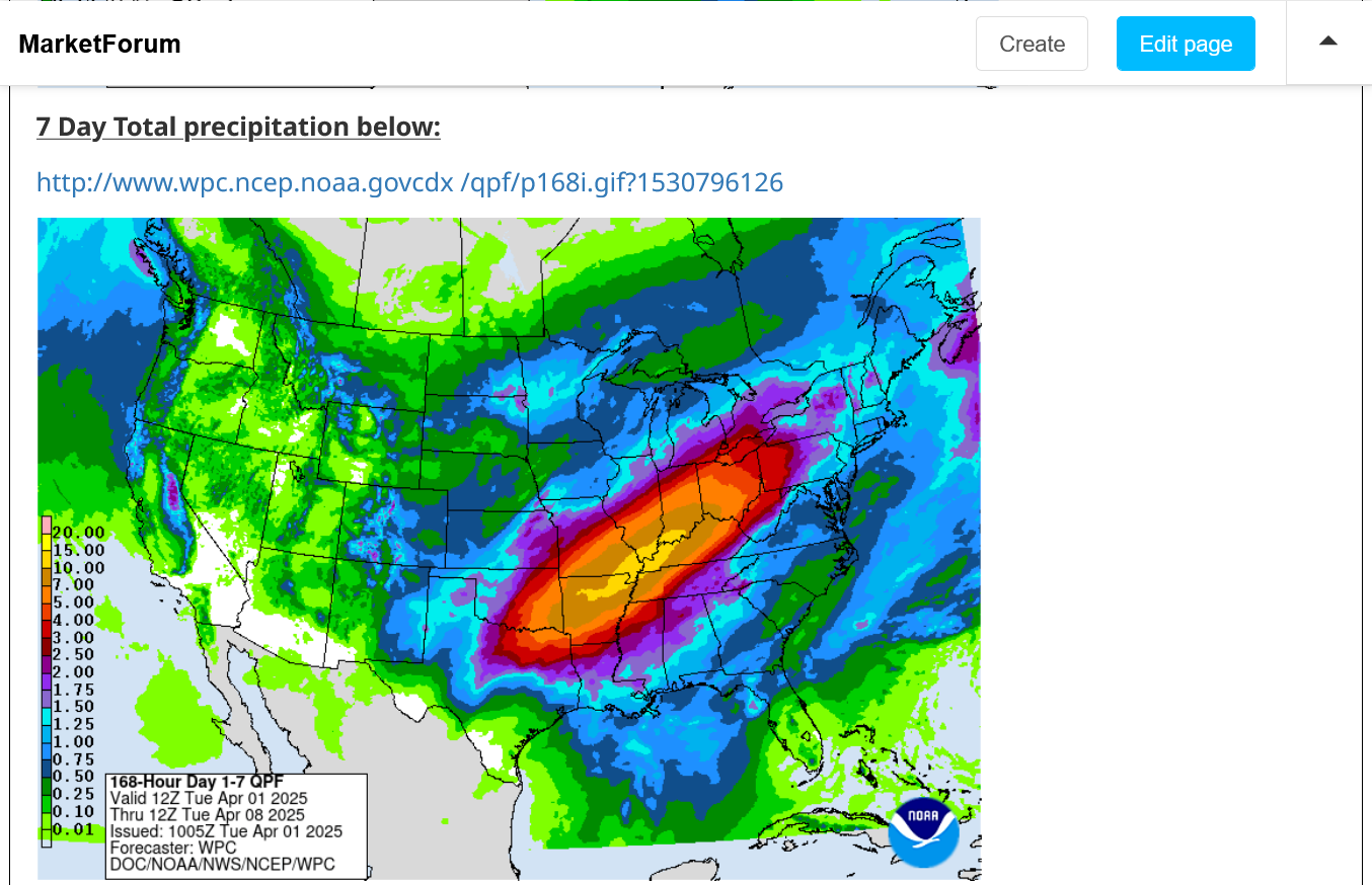
With regards to rains, the forecast has actually INCREASED rain. Evansville is now inside of the 10"+ yellow band, which has been expanded north.
https://www.marketforum.com/forum/topic/83844/#83848
Tracking the storm.
We'll be needing at least 1 more thread on Wednesday to continue this because of so information to share for a pretty long period. Then another thread to track the flooding which escalates later this week. Stay tuned.
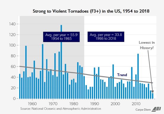
Also, please put this into perspective. Extreme weather like this has happened before(our worst tornado outbreaks, by far were in the 1970s and prior to that with exceptions like the Joplin, MO tornado outbreak in 2011).
The biggest difference today is that we have the technology to detect much more of it and well before it happens. Then bombard everybody with that information using communications that nobody imagined possible 3+ decades ago.
This is causing 3 things to happen:
1. Resulting in everybody being much, MUCH better informed by several orders of magnitude.
2. Resulting in LESS deaths/injuries because informed people can be prepared BEFORE the life threatening weather hits.
3. Makes it seem much worse because, before "ignorance was bliss". Now, "enlightenment causes anxiety". Knowing what's out there is scary to some people but its a good thing if you can put it into perspective. Being killed in a car crash is 1,000 times more likely than being killed by a tornado. Are you afraid to get into your car to go on a trip? I hope not.
Put on your severe weather seat belts and enjoy the enlightenment and benefits of technology!!!

The Wednesday severe weather outbreak storm has been deepening rapidly today:
Current Conditions below updated every few minutes.
UPPER MIDWEST
https://www.spc.noaa.gov/exper/mesoanalysis/new/viewsector.php?sector=13#


https://www.spc.noaa.gov/exper/mesoanalysis/new/viewsector.php?sector=13#

LOWER MIDWEST
https://www.spc.noaa.gov/exper/mesoanalysis/new/viewsector.php?sector=20

https://www.spc.noaa.gov/exper/mesoanalysis/new/viewsector.php?sector=20#

https://www.spc.noaa.gov/exper/mesoanalysis/new/viewsector.php?sector=20# 
It's drawing up warm/humid air ahead of it with cold/dry air to the north. Temperature contrasts/boundaries feed storms and provide lifting/triggering mechanisms.
https://thermastor.com/dew-point-and-weather-maps/

https://www.wunderground.com/maps/radar/current

Winter Weather Forecasts
https://www.wpc.ncep.noaa.gov/wwd/winter_wx.shtml
+++++++++++++++
Current Hazards at the link below.
For your NWS and county, go to the link below.
Then you can hit any spot on the map, including where you live and it will go to that NWS with all the comprehensive local weather information for that/your county.
New radar product below
Go to: "Select View" then "Local Radar"
Hit the purple circle to see that local radar site
+++++++++++++++++++++++
This link below provides some great data. After going to the link, hit "Mesoanalysis" then, the center of any box for the area that you want, then go to observation on the far left, then surface observations to get constantly updated surface observations or hit another of the dozens of choices.
 |
Day 2 afternoon update. They finally decided on where to put the moderate, level 4 risk area which includes Evansville.
++++++++++++++++++++++
Tornado risk below = 15% for a tornado within 25 miles of any point. Violent tornadoes possible on Wednesday.

+++++++++++++++++++++++++++++++++++
Severe Thunderstorm winds =30% chance within 25 miles of any point on Wednesday.
Winds outside of thunderstorms could gust to near 50 mph!

Extremely heavy rain with flash flooding is very likely later this week. The front that acts to trigger the severe weather outbreak on Wednesday will stall out because the upper level jet stream will remain southerly, which will push back the surface winds from the north trying to shove the front to the south.
This is the flash flood outlook for Thursday and Thursday Night. In the RARE HIGH category. This is a 70% chance of flash flooding within 25 miles of any point in that color.
This is actually much different than severe weather probabilities. With a tornado, even in a major, widespread outbreak, 99%+ of the people in the worst area will not get hit by a tornado.
However, when there is widespread flash flooding, the real heavy rains pound EVERYBODY in that 25 mile zone around you, especially with a pattern like this.
Then, its a matter of the low lying and flood prone areas getting impacted the most.
%20Interactive%20Display.png)
Total rains below from the Tue pm update. Yellow is 10+ inches.
Get the latest updates at this link:
https://www.marketforum.com/forum/topic/83844/#83848
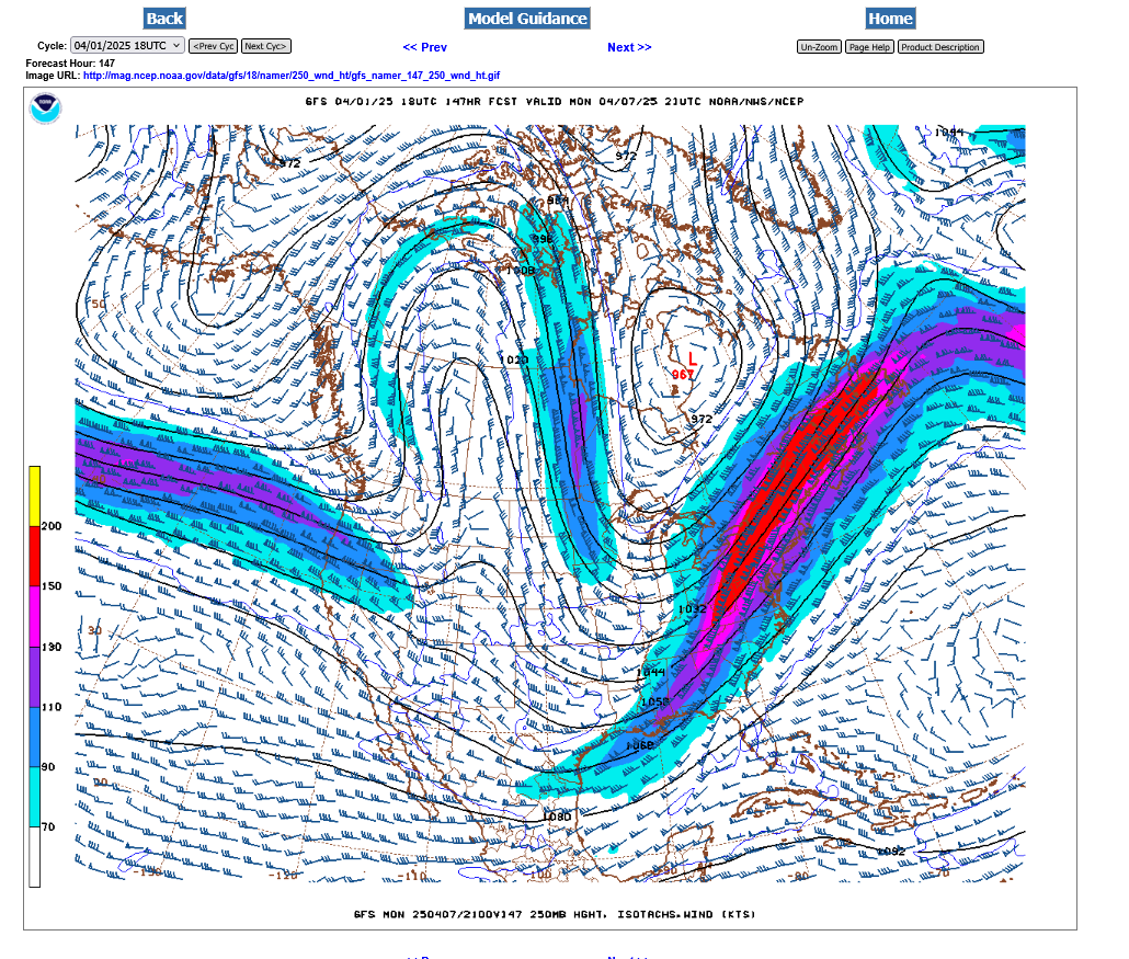
Look at this amazing 250 mb jet stream for the next 6 days:
+++++++++++++++++
Tuesday pm-200 mph jet streak in the base of the trough
 ++++++++++
Wednesday pm-Jet stream causing severe storm and tornado outbreak in the middle of the country-new energy feeding into the backside of the trough, redeveloping it and deepening it farther south and to our west, instead of allowing it to progress forward.
 +++++++++++++
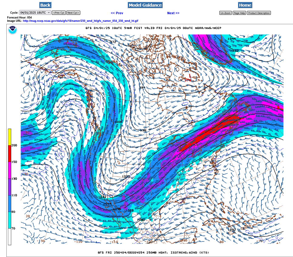
Thursday pm-very deep trough stalled to our west with strong southerly component to our upper level winds. Deep layered moisture gushing north and overunning some cooler at at the surface with perturbations in the strong flow triggering waves of very heavy t-showers.
+++++++++++++++++++++++++
Friday pm-upper trough still to our west with s/sw winds here. Fresh batch of strong winds from northwest Canada NOT feeding the trough but instead, positioned to kick it out finally over the weekend.
 ++++++++++++++++++++++++++
Saturday pm- the last of the strong sw jet stream over us.
++++++++++++++++++++++
Sunday pm-the jet stream that caused the severe weather and flooding in finally to our east. A new, potent Northern stream is taking aim at us with some very chilly weather for the 2nd week of April.
++++++++++++++
Monday pm-Very chilly air pushing in for early/mid NEXT week:
As expected, the Storm Prediction Center is adding higher risk categories as we get closer to the main event. A couple hours ago, they updated their day 1 map and added a HIGH risk, inside the MODERATE risk they added Tuesday afternoon. This doesn't mean the storm is developing stronger than expected, it just means the Storm Prediction Center waited to be sure of the HIGH risk areas because assigning that level 5 out of 5 risk is pretty rare and people in a HIGH risk area need to be ready to go to a safe place HOURS before any tornado warnings are issued.
The dynamics from this storm are such that EF3+ tornadoes are possible. This means winds of 136 mph or more. Even a 200 mph tornado is possible. 
TORNADO RISK BELOW: 30% IN THE HIGH RISK. EVANSVILLE ~25% chance of a tornado within 25 miles of any location.
Excessive rain forecast has a tad less rain but not much change. Yellow below is 10+ inches. Some places could see 15 inches in that zone. Most of this rain will be falling from Wednesday afternoon thru Sunday morning.
If your basement or crawl space has a sump pump that goes off repeatedly during very heavy rain events and keeps the lowest level of your house from being flooded, you should have a back up battery ready to do the job in case you lose power on Wednesday from a severe storm outage. If power is out for a couple of days, THEN this much rain fell, an excessive amount of water could flood your basement.
We learned the hard way almost 10 years ago when that exact thing filled our finished basement with over a foot of water.
Latest detailed rain forecasts here:
https://www.marketforum.com/forum/topic/83844/#83848
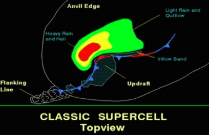
Today's tornado outbreak is likely to come from Supercell Thunderstorms:
https://www.weather.gov/ama/supercell
++++++++++++
Excellent presentation at this link below that describes the different types of tornadoes and the damage they cause. Keep in mind that the EF4 and EF5 tornadoes are extremely rare. Less than 1% of tornadoes are this strong. Today is one of those rare days.
The EF4 and EF5 tornadoes will usually have the HIGH, level 5 risk earlier that day.
Mike Simon Tornado Damage Intensity; Enhanced Fujita Scale
https://www.youtube.com/watch?v=p-653tSCB68
+++++++++++++++++
![]()
https://www.tornadofacts.net/enhanced-fujita-scale/ef0-tornado.html
The most common and least powerful of all tornadoes are those within the EF0 category. An EF0 tornado is closer in strength to what one might expect out of a straight-line wind during a thunderstorm, or a strong gust on a windy day. With speeds ranging from 65-85 mph, damage is typically minimal, and injuries or deaths are rare with EF0s. However, despite their relatively weak nature, these twisters still have the potential to inflict harm and damage on communities.
++++++++++++++++
Enhanced Fujita scale
https://en.wikipedia.org/wiki/Enhanced_Fujita_scale
| EFU | Unknown | No surveyable damage |
|---|---|---|
| EF0 | 65–85 mph | Light damage |
| EF1 | 86–110 mph | Moderate damage |
| EF2 | 111–135 mph | Considerable damage |
| EF3 | 136–165 mph | Severe damage |
| EF4 | 166–200 mph | Devastating damage |
| EF5 | >200 mph | Incredible damage |
+++++++++++++++++++++++++++++++
Here's the deal on wind and damage.
As wind increases the damage massively increases on an exponential scale. This applies to ALL wind.
Severe storms and hurricanes and especially tornadoes that have the strongest winds of all, which means the tornadoes with winds over 150 mph have incredible damage.
+++++++++++++++++++++
A 150 mph wind does 256X more damage than a 75 mph wind. Let's repeat that. A 150 mph wind does 256x more damage than a 75 mph wind!
Being enlightened with this authentic science/physics should not scare you but instead, can empower you because you understand it and can use that enlightenment to be in a safe place IF/WHEN a very low probability violent tornado targets your location.
Hurricane Damage Potential
https://www.noaa.gov/jetstream/tc-potential
++++++++++++
Less than 1% of tornadoes are F4 or F5 but they kill 67% of the people!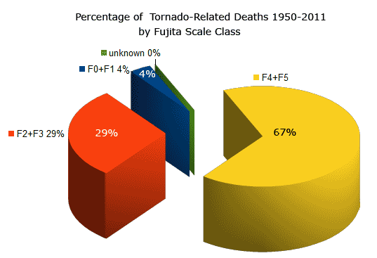
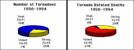
Note that the majority of tornadoes, F0 and F1= 74%(on the old scale) only killed 4% of people.
The F4 and F5's were just 1% but caused 67% of deaths.
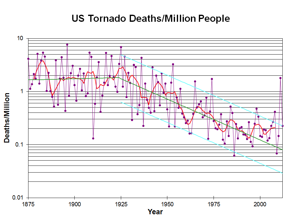
Knowing that a violent tornado may be headed towards your location, thanks to technology and being in a safe place is the main reason for this graph to show plunging fatalities from violent tornadoes. That 1 spike near the end was from the Joplin MO, tornado of 2011.
Note the drop that coincided with the start of the technology(radars and radio/tv communications, including weather radios).
The graph below is logarithmic. Tornado deaths today are around 10% what they were 100 years ago.
https://inside.nssl.noaa.gov/nsslnews/2009/03/us-annual-tornado-death-tolls-1875-present/
+++++++++++++++++++++++++++++
Another important authentic science/meteorology item is that climate change has REDUCED the number of violent tornadoes and tornado deaths.
https://www.marketforum.com/forum/topic/110407/#110432
Re: Re: Severe weather #2 May 7-8, 2024
By metmike - May 10, 2024, 12:11 a.m.
Why is this?
Meteorology 101 tells us what happens when the planet sees the temperature of the highest latitudes (coldest places, especially coldest time of year) warmed up the most. This is beneficial warming! Reduced meridional temperature gradient..........weaker cold fronts and jet streams.
Weather becomes LESS extreme in several realms!
+++++++++++++++++++
Regardless of the stats above, on days like today we have the opportunity to save lives by going to our safest place in the event that a tornado WARNING is issue for your county. Most tornado warnings are for weak tornadoes, less than 110 mph that don't hurt anybody. Today's tornadoes could have 150+ mph winds.
https://www.weather.gov/pah/weatherstory
++++++++++++
Even without a severe thunderstorm, pressure gradient wind gusts could be 50+ mph.
https://www.spc.noaa.gov/exper/mesoanalysis/new/viewsector.php?sector=20#
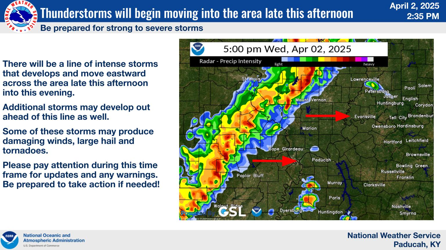
Main line of storms taking shape along the western edge of the Tornado watches.
Also NEW, discrete potentially very dangerous storms developing well ahead of this. These could impact us this afternoon.
The main line of storms will get here this evening.

Current Hazards at the link below.
For your NWS and county, go to the link below.
Then you can hit any spot on the map, including where you live and it will go to that NWS with all the comprehensive local weather information for that/your county.
New radar product below
Go to: "Select View" then "Local Radar"
Hit the purple circle to see that local radar site
+++++++++++++++++++++++
This link below provides some great data. After going to the link, hit "Mesoanalysis" then, the center of any box for the area that you want, then go to observation on the far left, then surface observations to get constantly updated surface observations or hit another of the dozens of choices.
| |
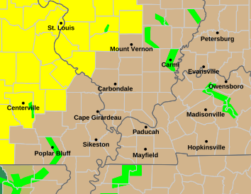
This tornado watch box in yellow is effect until 4pm. There may be very dangerous severe storms that try to form AHEAD of the main line! Discrete thunderstorms, we call them.

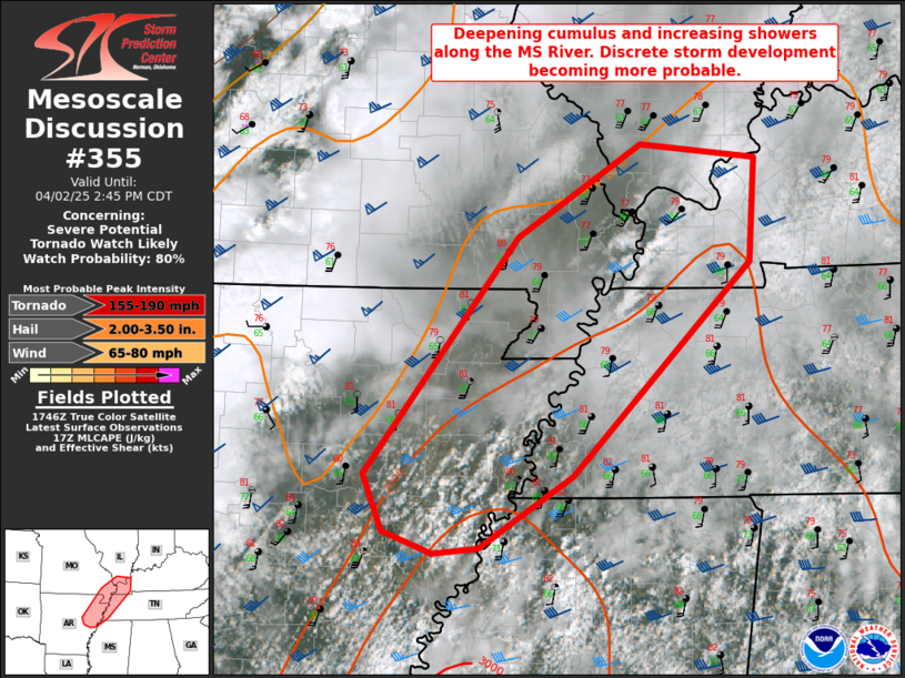
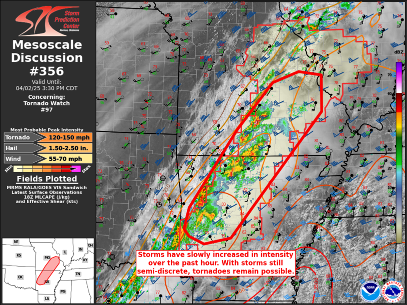
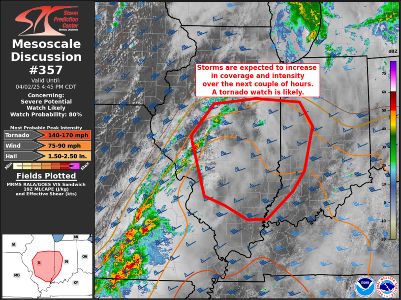
Our first mesoscale discussion of the day, just after 1pm. 80% chance of a tornado watch issued in the red region, just southwest of Evansville.
Note that the tornadoes they expect are up to 190 mph! That would be strong EF 4 tornadoes. These are DISCRETE CELL severe thunderstorm/tornadoes.
https://www.spc.noaa.gov/products/md/md0355.html
+++++++++++++
Be prepared later today to go to a safe place for any tornado warnings. This has happened before so its nothing unprecedented.
MANY more people survive extreme weather events in 2025 compared to 1925, in a big part because WE CAN PREPARE AHEAD OF TIME!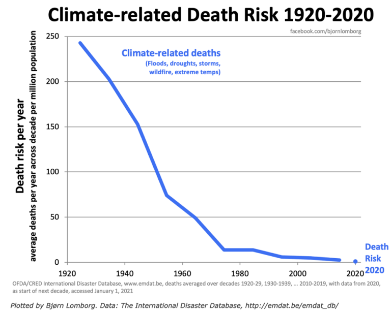
Not much severe weather YET( thru 1pm):
https://www.spc.noaa.gov/climo/reports/today.gif
+++++++++
2pm: This is still far to our west/southwest associated with the main/organized line:
https://www.spc.noaa.gov/products/md/md0356.html
This mesoscale discussion above mentions tornadoes with top winds of 150 mph along the main line. This is still a strong tornado but why not 190 mph, like for tornadoes way out ahead of the main line, like those mentioned in the earlier mesoscale discussion??
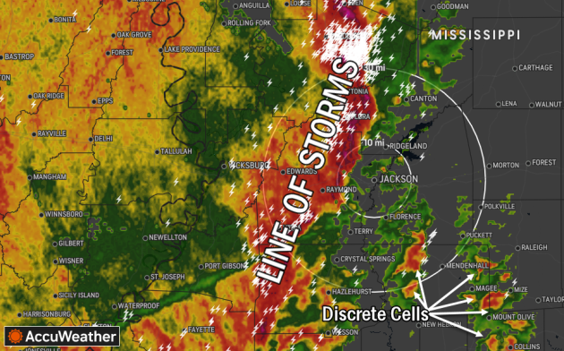
The strongest tornadoes often come from DISCRETE CELL Thunderstoms!!!
++++++++++++++++++++++
What are 'discrete cell' thunderstorms?
Discrete cell thunderstorms can produce the world's strongest tornadoes -- so what do they look like?
https://www.accuweather.com/en/severe-weather/what-are-discrete-cell-thunderstorms/1163815
++++++++++++
The good news is that the area the SPC was concerned about with an 80% chance of a particularly dangerous, strong tornado watch box......... with rapidly developing DISCRETE CELLS a couple of hours ago........has seen them ......ALL DIE OUT!
Why did that happen? Not sure but this is what makes predicting discrete cells ahead of the main line especially challenging. We know with high certainty that there will be a long line of severe storms ahead of the cold front. That is still 6 hours or so away. Those will do the most OVERALL damage because of their widespread extend.
However, an individual discrete cell tornado well ahead of that line has the highest potential for the most violent winds. So its good to see the currently quiet radar as we approach 3pm.
++++++++++
This is the latest timing. Maybe after 8pm for the main line of storms? Hopefully no well developed discrete cells before then.

The storms are getting ready to hit St. Louis here around 3:30pm.
This time we WILL see a tornado watch inside the area outlined in red below. It almost included Evansville. There will be additional tornado watches farther south for certain.
https://www.spc.noaa.gov/products/md/md0357.html
OK, we already have our main tornado watch until Midnight. Longest watch box I remember seeing the past 4 decades, 9 hours long.
This is to also cover potential discrete storms cells that develop ahead of the main line that's still, possibly 6 hours away.
They mention the potential of multiple rounds of severe storms in some areas and, as we already knew violent, long track tornadoes could happen.
On the radar frame below, we can see discrete storms popping up well to our south. Well ahead of the main line in IL/MO/AR. This is in the HIGH, level 5 risk area. Our risk is close to that too but not quite the highest.
https://www.spc.noaa.gov/products/watch/ww0098.html
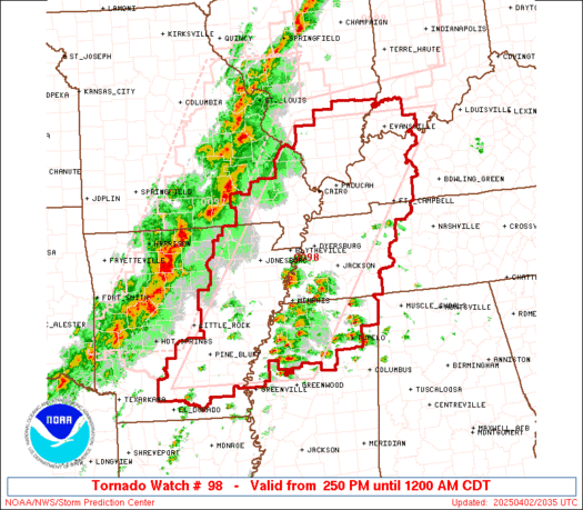
Tornado watch until Midnight:
+++++++++++
Still not a great deal of severe weather reports but its barely gotten started:
https://www.spc.noaa.gov/climo/reports/today.gif

Things are about to get crazy!
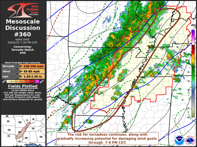
Last mesoscale discussion from the SPC, good thru 7:30pm that includes Evansville. Tornadoes up to 150 mph are possible. 80 mph wind gusts, 2.5" hail.
https://www.spc.noaa.gov/products/md/md0360.html
6:30 pm. The reds are tornado warnings.
++++++++++++++
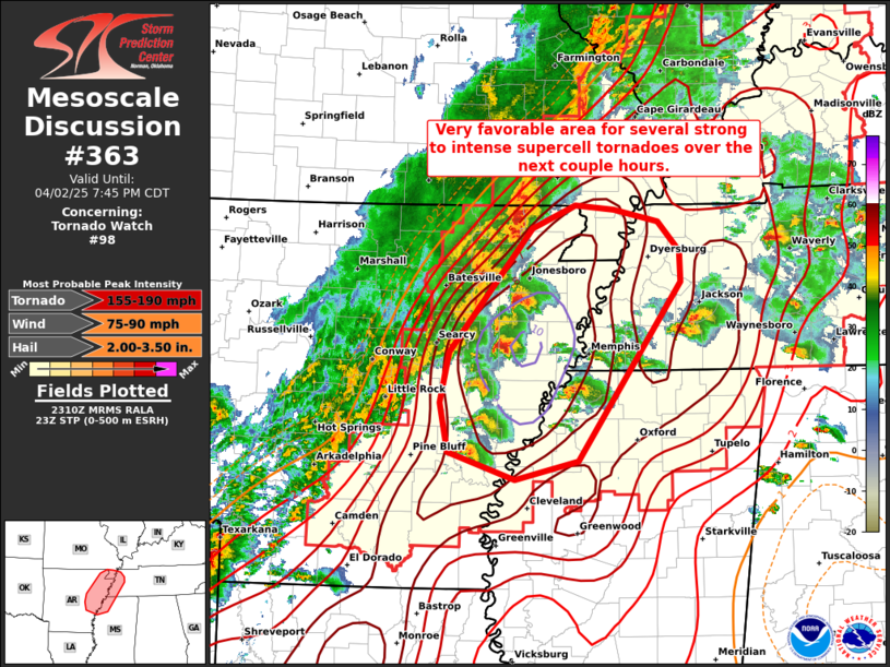
This is the highest risk area TO OUR SOUTH. High risk for storms with tornadoes to 190 mph. 90 mph severe thunderstorm winds and 3.5" hail.
https://www.spc.noaa.gov/products/md/md0363.html
Tornado warning for Vanderburgh County. Looks like the storm should hit just before 8pm.
No confirmed tornadoes yet though. Just radar indicated so its likely not a violent tornado.
To be on the safe side, I would go to your safe spot when you hear the storm getting close WELL BEFORE 8pm.
If you're watching WEHT-TV with Wayne Hart or another station with live radar, this will give you the best, to the minute info.
The severe storm is a possible radar indicated tornado just east of mt Vernon In. Still at least 15 minutes from Evansville's north side.
looks like it may pass barely northwest of us around 8:16pm But it’s close And it could turn to the right and hit us.
Be in your safe place.before 8:15pm Because this storm has a hook on it, even if it passes just northwest.
A new serious storm with a potential for a long track significant tornado is in southern IL and may arrive around 9pm? Make that AFTER 9pm.
new tornado warning is NORTH of Melody Hill And for northern vanderburg co.
this is radar indicated and apparently NOT a violent tornado right now.
At 8:20 pm, we’re good for now until the main line gets here after 9 pm.
Waiting for the main line to pass thru after 9pm. So far so good:
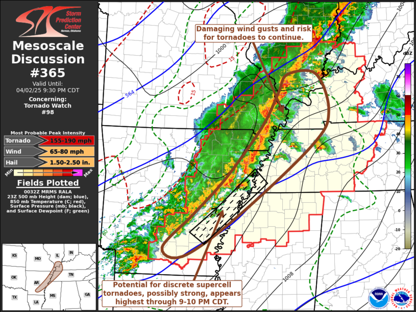
The highest risk of violent, 155-190 mph tornadoes is SOUTH OF US!
However, when this main line goes thru, a strong tornado is still possible.
https://www.spc.noaa.gov/products/md/md0365.html
Ryan Hall is reporting a tornado right near the Paducha KY weather radar.9:30EDT
Excellent link/source, cutworm. Thanks man!
New warning for Vanderburgh County for the main line of storms.
Not sure of the details. Sirens just went off. Be ready to go to your safe place before these storms hit.
JUST A SEVERE THUNDERSTORM WARNING. No reported tornadoes.
It’s a bow echo that is racing east very fast so it will hit us just after 9pm and they just upgraded to a tornado warning.
good time to be in your safe place until this storm passes
The storm passed thru. The new warning is likely a flash flood warning.
Tornado risk is over.
we have no power so I cant access my computer and much of the information,
Somebody messed by continuing to sound the sirens 2 different times after the storms from the mainline went thru.
We have no power.
Ok, it looks like the NWS warnings from Paducah messed up a bit too.
They issued a severe thunderstorm warning for V county at 9:06pm then a tornado warning for a different part of V county at 9:08pm and the storms were racing so fast east that they were already east of V county when the warnings went out.
Then the sirens went off 2 times 15 minutes after the storms had passed thru.
Also they had a flash flood WARNING in effect for 6 hours from less than an inch of rain and when all the heavy rains had shifted south of us for hours.
The NWS always does a wonderful job and I mainly mention this to readers that might have been confused and thought some things were happening that they missed.
They just got overloaded with everything and possibly, knowing the extreme risks, including for flash flooding and especially knowing their warnings are what save the most lives had some human errors.
I couldn’t do that job any better and make mistakes all the time so issuing too many warnings is better than missing 1 that ended up deadly.
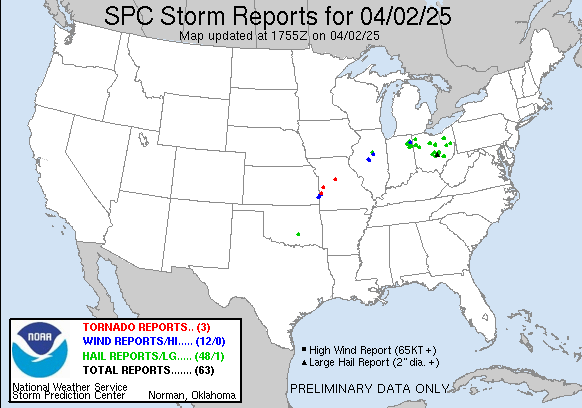
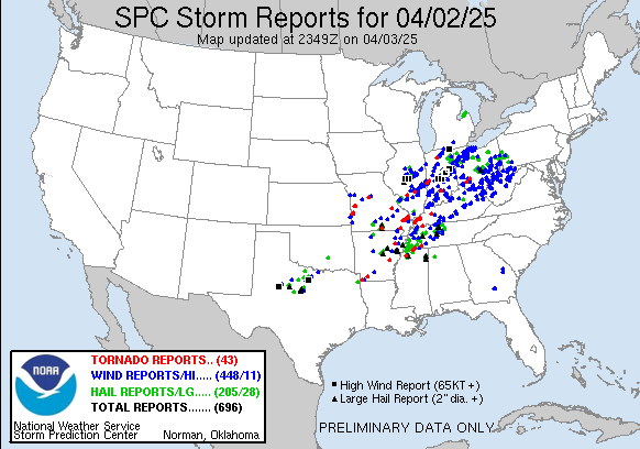
Looks like there were only 27 total tornadoes yesterday, 200 hail reports and 350 damaging wind reports For the preliminary storm report.
Hopefully, Centerpoint will have our power back on soon.
My IPhone battery died so I’m recharging it in my car.
good thing I went out to inspect the neighboorhood for damage.
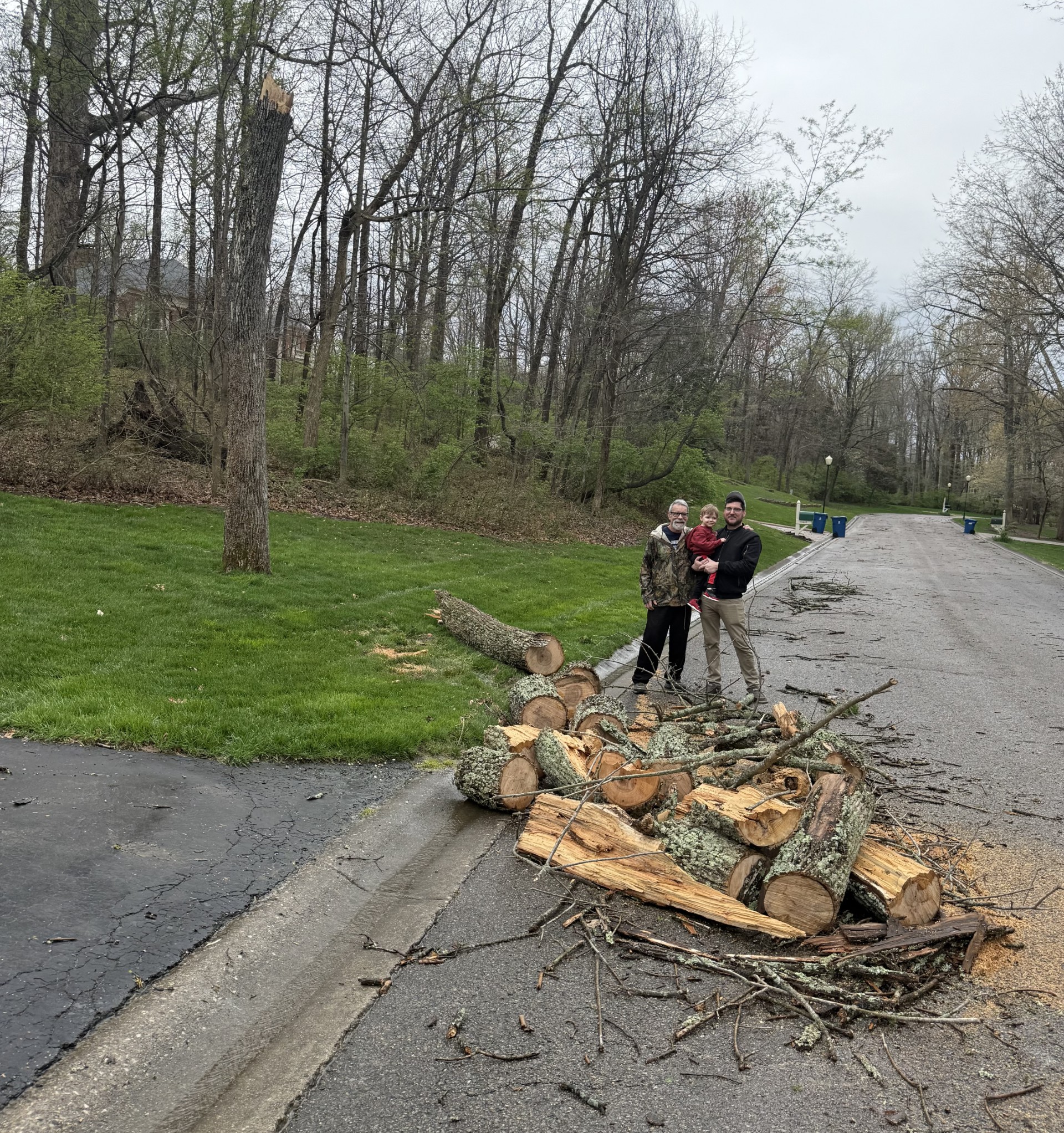
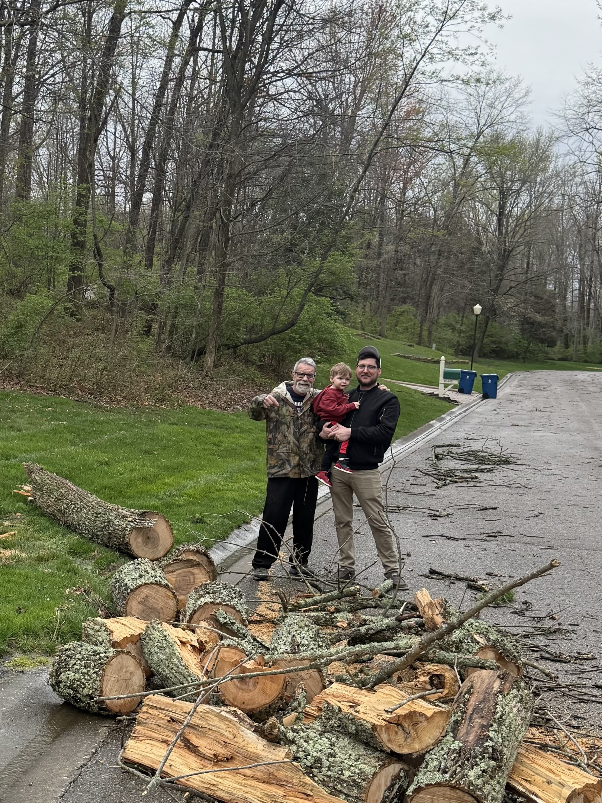
We had a huge tree on our property fall completely across the road in front of our house. Neighbors would need to turn around and take another way out or in.
Luckily, I just bought a new chain for my chainsaw so Ive been cutting iup the tree into manageable pieces with a fast cutting chainsaw.
technology is so awesome!
Now there’s thousands of pounds of cut up wood on the side of our street. I know a guy that might use it.
Still no power so I cant use the computer of do much updating.
The good news is on several fronts.
Rains amounts for Evansville are down closer to 7 inches now.
WE DODGED A BULLET LAST NIGHT. The only severe weather report I can see from Vanderburgh County was a 64 mph wind gust from an ASOS station 2 miles north of Melody Hills, at 10:02 pm which was from the same storm that snapped our tree.
+++++++++
There is just a slight risk for any storms we see to turn severe the next 3 days.
Power is back!
This is the preliminary storm report for yesterday, April 2,2025.
As the NWS does surveys of the damage, the number of tornadoes will go up.
https://www.spc.noaa.gov/climo/reports/yesterday.gif

Go to this link and hit your county:
++++++++++
Rain amounts MUCH less than earlier in the week.
https://www.marketforum.com/forum/topic/83844/#83848
As the NWS goes out to the hundreds of damage sites the next several days, their surveys are finding more tornadoes as well as additional damage reports coming it. This map was as of Thursday evening. You can see the individual reports at the link below:
https://www.spc.noaa.gov/climo/reports/250402_rpts.html
Image:
https://www.spc.noaa.gov/climo/reports/yesterday.gif
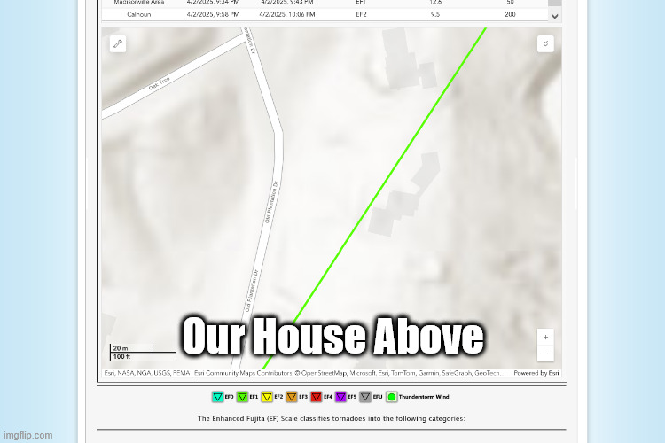
Hey, NWS! Here's a damage report for you..........on our front lawn.
An Automated Surface Observing System instrument reported a wind gust of 64 mph at 10:02pm, 2 miles north of Melody Hills, extremely close to our house.
However, this tree was snapped by a likely tornado(based on the debris surrounding it an hour earlier.
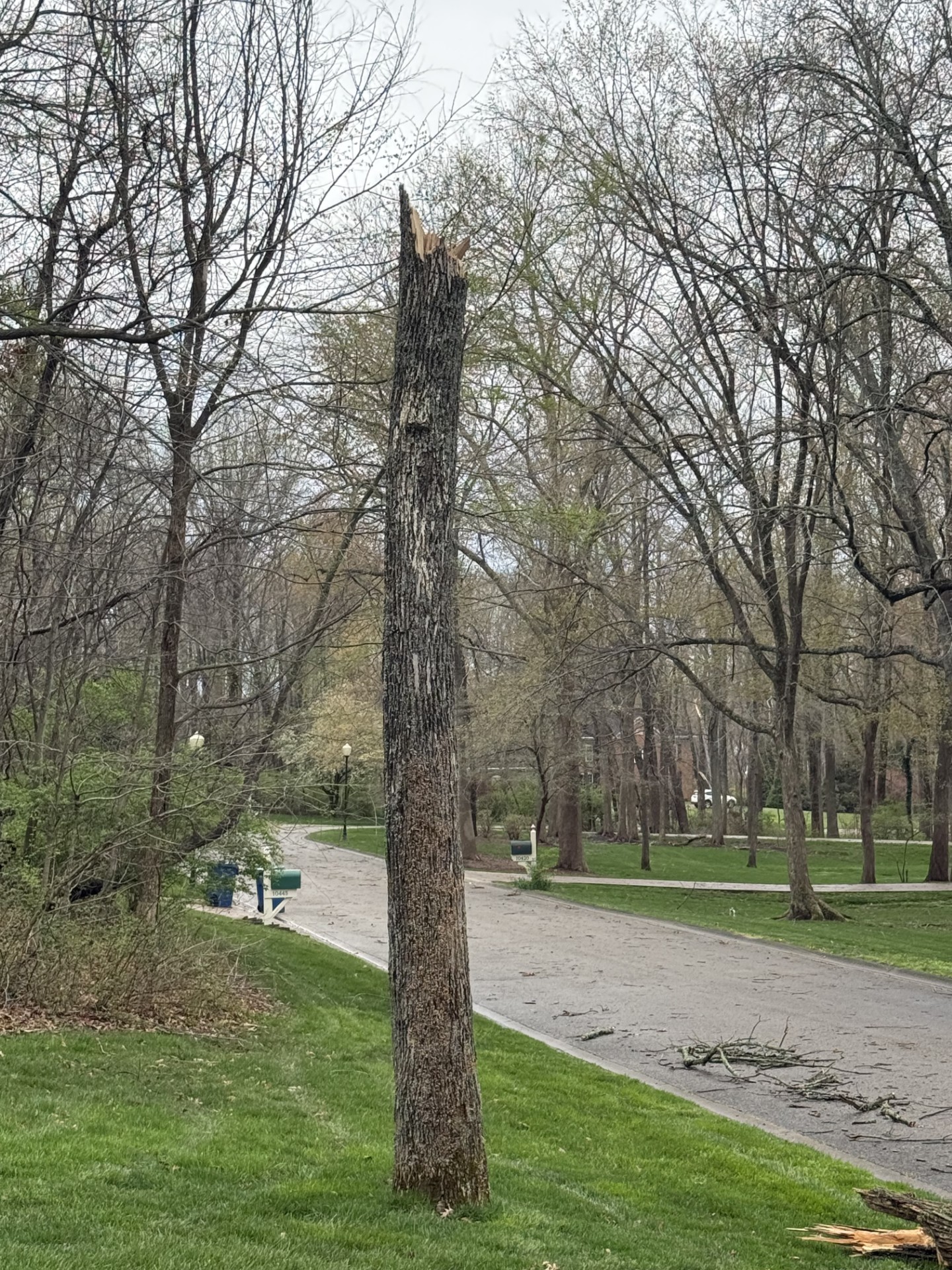


Mike-69, Cyrus-2, Quinn-37. The tree fell on Quinn's 37th birthday!
Thanks to Debbie(ageless wonder) for taking the pictures.
Modern technology is awesome. In less than 2 hours, just after midnight I had most of the fallen tree cut up (the other side of the street has a big pile too). The chainsaw ran out of gas just before cutting up the long log on the left.
Anybody that uses a chainsaw knows how much fun it is to chew thru wood with a sharp chain (this one was new) and how it stinks with a dull chain.
We also lost power for around 14 hours.
I joked earlier in the day that I was getting Quinn a tornado for his birthday.
On his 38th birthday, I'll get him a lottery ticket and wish for a million dollars
Severe storm reports and tornadoes from Wednesday's outbreak continue to pour in. A good example are the pictures on that last page. This could qualify as a report item if I submitted it. There were many dozens of similar type damage incidents that occurred in Vanderburgh county from that storm that QUALIFIED but will never make the official NWS report.
https://www.spc.noaa.gov/climo/reports/250402_rpts.html

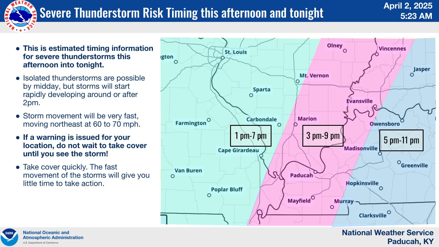
https://www.weather.gov/pah/2025April2Severe
+++++++++
The NWS has only started compiling this report. Much will be added in the days to come.
As expected tornado reports have increased to 73 and wind reports are up to 551. Adding in the hail and the total reports were 834 for last Wednesday:
https://www.spc.noaa.gov/climo/reports/250402_rpts.html

+++++++++++++++
The local NWS survey discovered damage that was caused by a WEAK tornado that touched down in Darmstadt, just after 9pm.
https://www.weather.gov/pah/2025April2Severe
WEAK Tornado track, crosses highway 41around 1 mile north of North High School. Peak winds 94 mph.
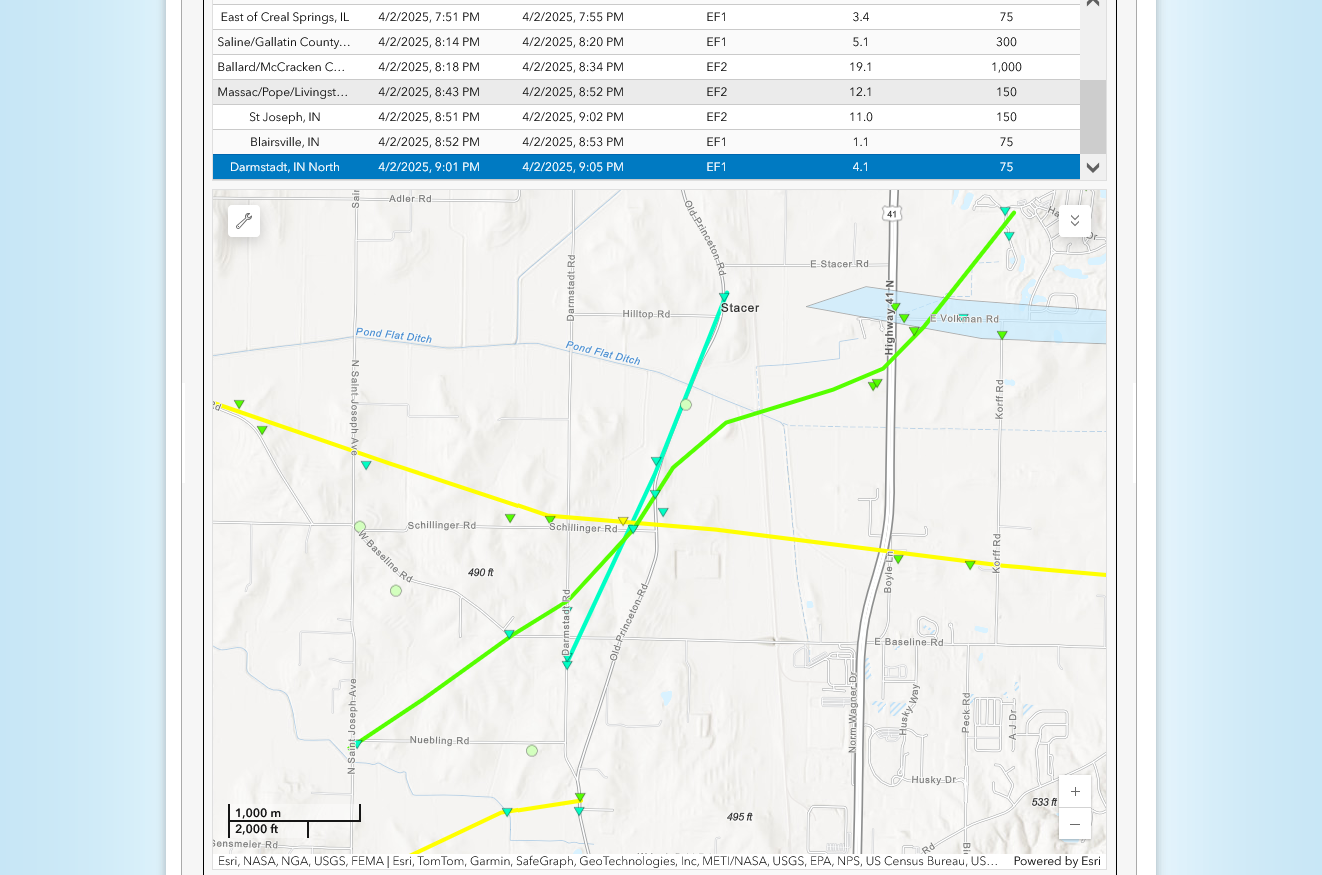
Verbal description: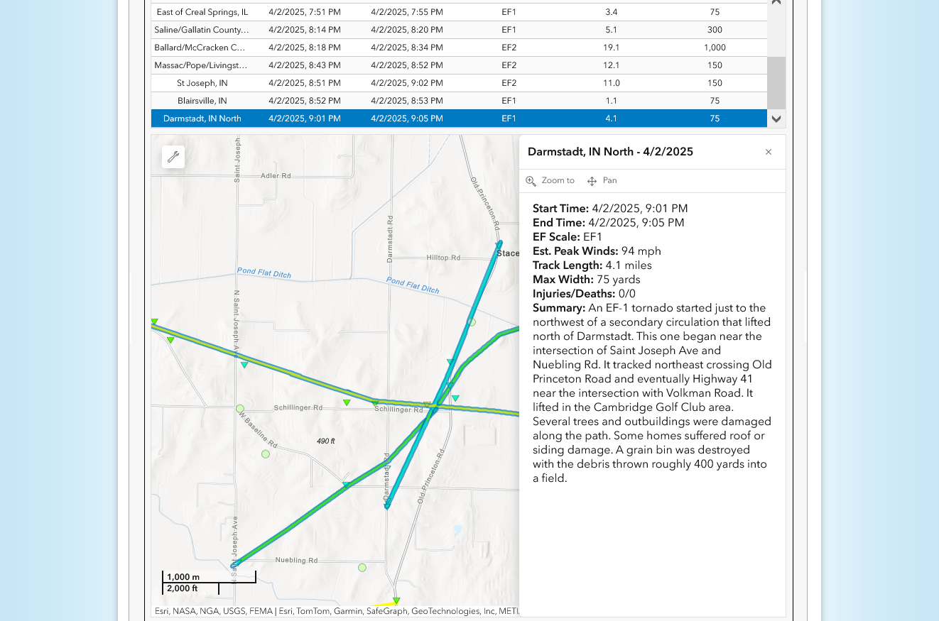
The number of severe weather reports continues to go up as the local NWS surveys the damage.
https://www.spc.noaa.gov/climo/reports/250402_rpts.html

The last update by our local NWS found this was actually a tornado that tracked right across our front lawn and driveway(with the circulation on its right side, directly over our house).
We also received hail at that time, shortly after 9pm, then again an hour later when a wind gust of 64 mph was reporting close to our house.
3-30-25 TORNADO outbreak on 4-2-25
By metmike - April 3, 2025, 9:25 p.m.
Hey, NWS! Here's a damage report for you..........on our front lawn.
An Automated Surface Observing System instrument reported a wind gust of 64 mph at 10:02pm, 2 miles north of Melody Hills, extremely close to our house.
However, this tree was snapped by a likely tornado(based on the debris surrounding it an hour earlier.

Mike-69, Cyrus-2, Quinn-37. The tree fell on Quinn's 37th birthday!
Thanks to Debbie(ageless wonder) for taking the pictures.
Modern technology is awesome. In less than 2 hours, just after midnight I had most of the fallen tree cut up (the other side of the street has a big pile too). The chainsaw ran out of gas just before cutting up the long log on the left.
Anybody that uses a chainsaw knows how much fun it is to chew thru wood with a sharp chain (this one was new) and how it stinks with a dull chain.
We also lost power for around 14 hours.
I joked earlier in the day that I was getting Quinn a tornado for his birthday.
On his 38th birthday, I'll get him a lottery ticket and wish for a million dollars
The NWS has added a bit more to their severe storm report the last 2 weeks.
+10 tornadoes
+12 severe thunderstorm wind reports
+7 hail reports
Total reports = 909 during this 24 hour period from 4-2-25 (7am) to 4-3-25 (7am)

Near final report from the April 2, 2025 tornado outbreak in our region.
https://www.weather.gov/pah/2025April2Severe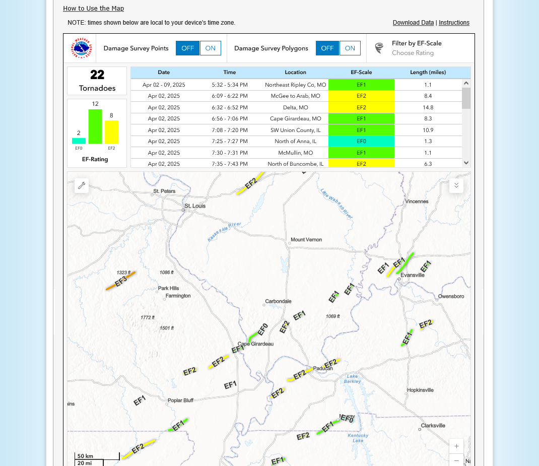
Numerous tornadoes but most of them weak and brief touchdowns. The NWS has just started their survey on the May 17, 2025 outbreak. It will be interesting to see how long the tornado that tracked across IL, into KY stayed on the ground and whether it was just an EF2(strong tornado) or whether is reached EF3.