
A POTENTIAL severe storm and tornado outbreak is expected later today in the Upper Midwest.
Edit: On further review, there are some factors and models that show not much happening today. This will likely NOT be an outbreak!
Any storms that do develop could be discrete cells that have access to all that atmospheric energy to themselves......which could result it isolated intense storms.
Get all the constantly updated weather here:
https://www.marketforum.com/forum/topic/83844/
+++++++++++++++++++
Previous threads:
3-30-25 TORNADO outbreak on 4-2-25
38 responses |
Started by metmike - March 30, 2025, 3:08 p.m.
https://www.marketforum.com/forum/topic/110789/
+++++++++++++++++++++++++++
4-4-25 Continuation of weather threats
26 responses |
Started by metmike - April 4, 2025, 12:50 p.m.
https://www.marketforum.com/forum/topic/110908/
+++++++++++++++++
3-25-25 Severe weather for 3-30-25
https://www.marketforum.com/forum/topic/110671/
+++++++++++++++++++++
Tracking Severe Weather-3-14-25
https://www.marketforum.com/forum/topic/110445/
+++++++++++++++++
Severe weather outbreak 3-12-25
https://www.marketforum.com/forum/topic/110407/
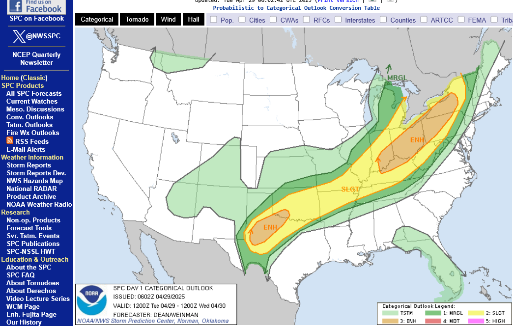
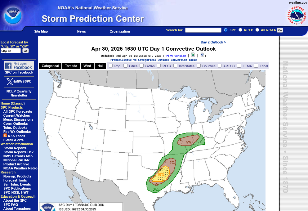
Latest outlooks from the Storm Prediction Center at 4am.
The updated graphics are on the next page.
1. Overall risk-moderate in the center
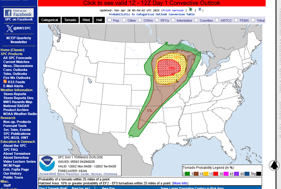
2. Tornado risk-chance of a tornado within 25 miles of any location.-15% = highest
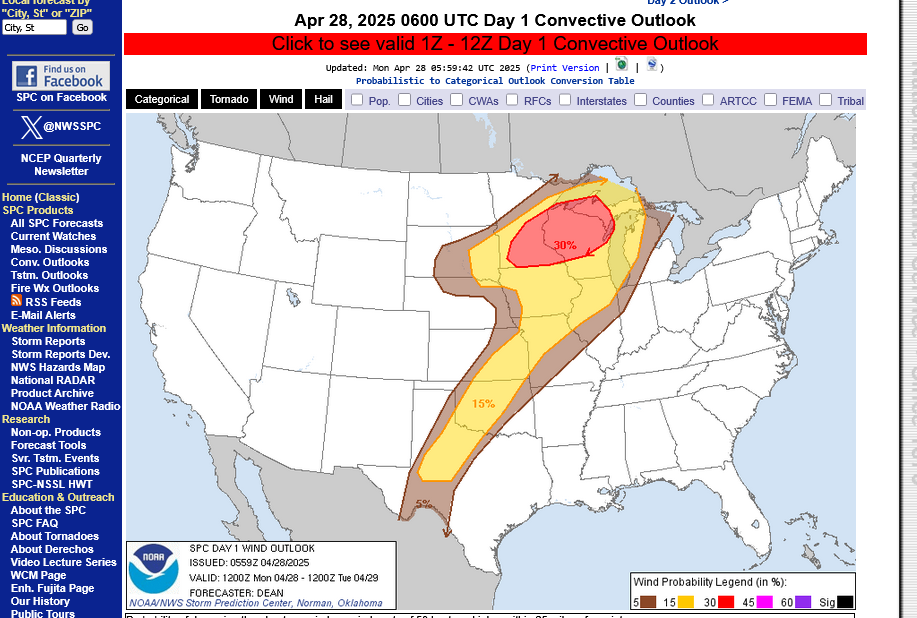
3. Severe storm wind risk-within 25 miles of any point=30% in the center
https://www.spc.noaa.gov/products/outlook/day1otlk.html
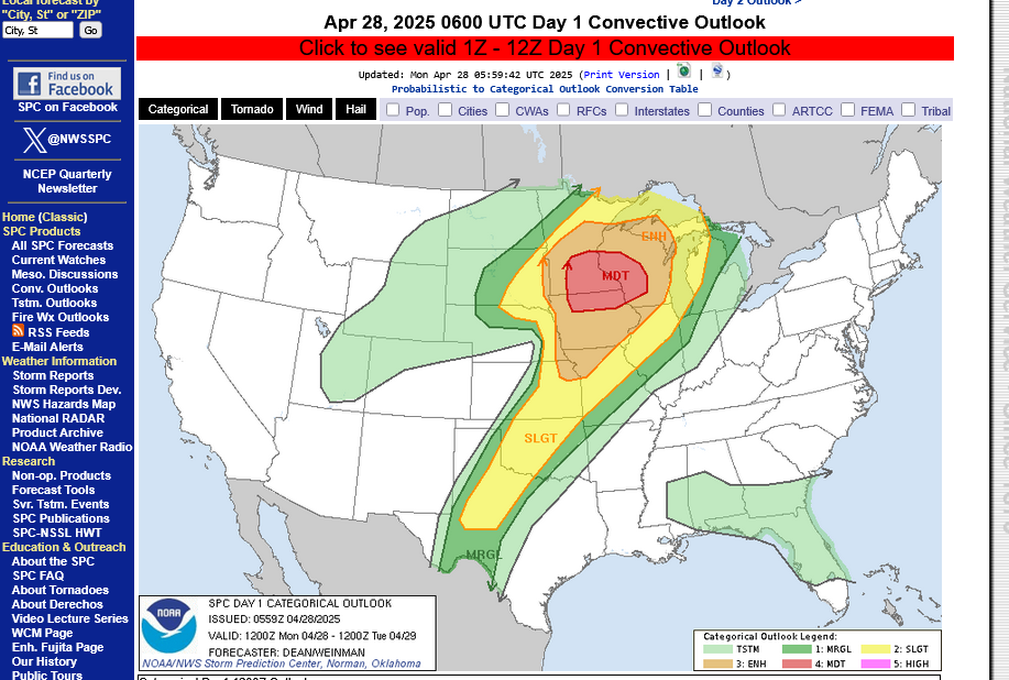

Go to this link and hit your county:
++++++++++
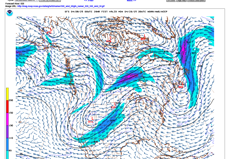
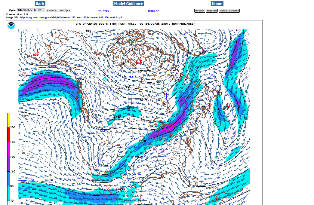
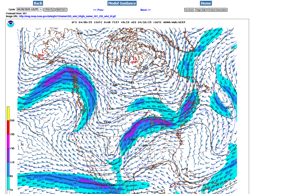
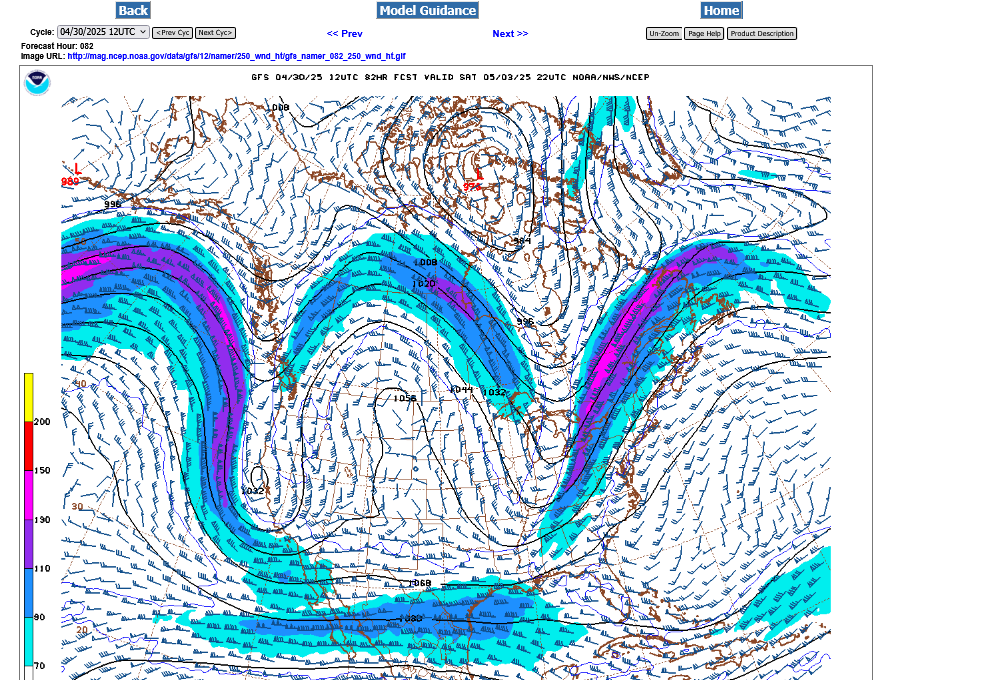
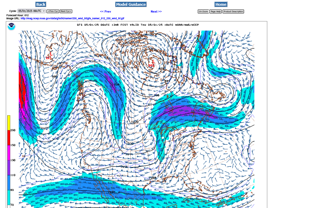
Upper level jet stream. 300 mb on Monday afternoon.
120 mph jet streak coming under an upper level trough centered in Utah with a wave/perturbation tracking in the flow, crossing the Central Plains into the Upper Midwest.
Storms will fire up ahead of the wave(and surface dry line/cold front below it in the afternoon heating. Probably not many tornadoes. This is not an overly impressive jet stream.
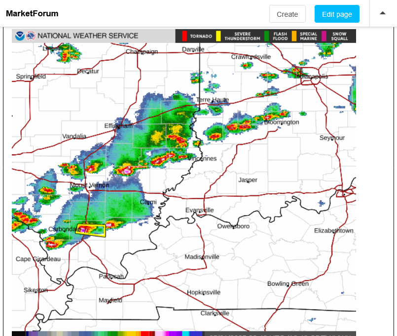
Tracking the storm!
Current Conditions below updated every few minutes.
UPPER MIDWEST
https://www.spc.noaa.gov/exper/mesoanalysis/new/viewsector.php?sector=13#


https://www.spc.noaa.gov/exper/mesoanalysis/new/viewsector.php?sector=13#

LOWER MIDWEST
https://www.spc.noaa.gov/exper/mesoanalysis/new/viewsector.php?sector=20

https://www.spc.noaa.gov/exper/mesoanalysis/new/viewsector.php?sector=20#

https://www.spc.noaa.gov/exper/mesoanalysis/new/viewsector.php?sector=20# 
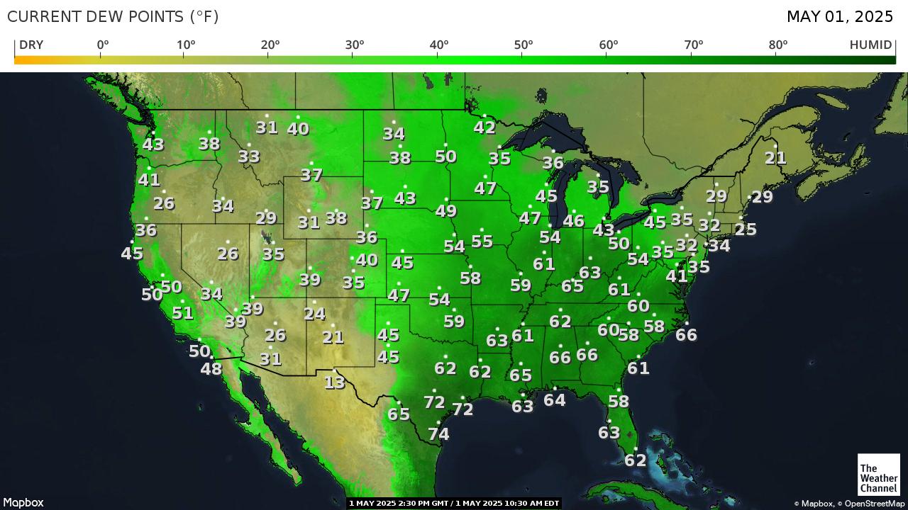
It's drawing up warm/humid air ahead of it with cold/dry air to the north. Temperature contrasts/boundaries feed storms and provide lifting/triggering mechanisms.
https://thermastor.com/dew-point-and-weather-maps/

https://www.wunderground.com/maps/radar/current

Winter Weather Forecasts
https://www.wpc.ncep.noaa.gov/wwd/winter_wx.shtml
+++++++++++++++
Current Hazards at the link below.
For your NWS and county, go to the link below.
Then you can hit any spot on the map, including where you live and it will go to that NWS with all the comprehensive local weather information for that/your county.

New radar product below
Go to: "Select View" then "Local Radar"
Hit the purple circle to see that local radar site
+++++++++++++++++++++++
This link below provides some great data. After going to the link, hit "Mesoanalysis" then, the center of any box for the area that you want, then go to observation on the far left, then surface observations to get constantly updated surface observations or hit another of the dozens of choices.
 |
https://www.youtube.com/watch?v=XDEynt1FD8w
Ryan Hall Y'all:
Tuesday's risk has shifted much farther southeast. The jet stream is NOT favorable for tornadoes. A tornado is possible but it's UNLIKELY to see a violent, long track tornado with such a weak jet stream.
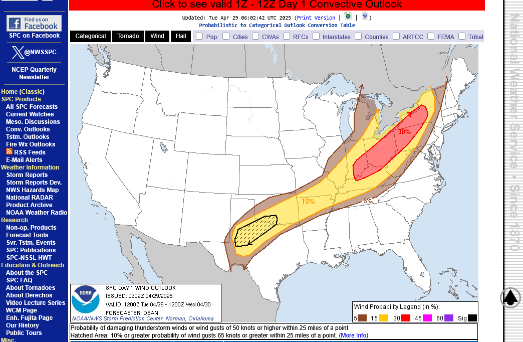
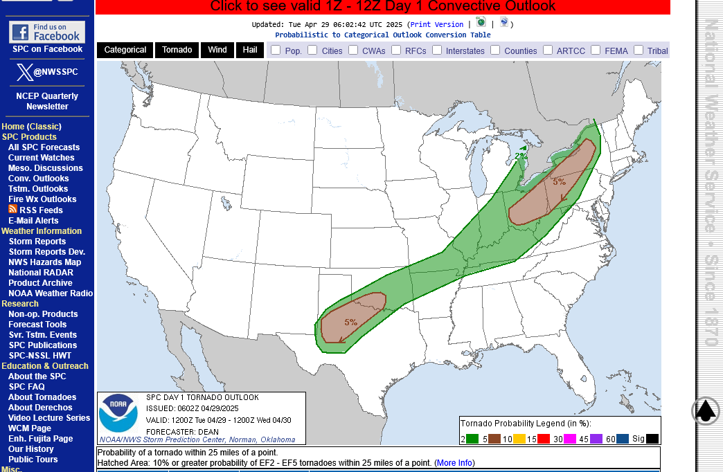
https://www.spc.noaa.gov/products/outlook/day1otlk.html
1. Categorical risk. "almost" level 3 enhanced for Evansville, In........mainly for wind not tornadoes
2. Wind threat. Almost 30% chance of a severe thunderstorm with winds of 58+ mph within 25 miles of any location.
3. Tornado threat: Just 2%+ chance of a tornado within 25 miles of any location.
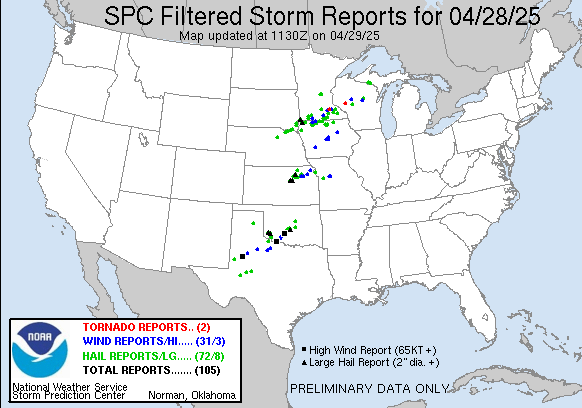
Severe storm reports the past 24 hours(Monday/Monday Night). Only 2 weak tornadoes. 31 high wind reports. NOT an outbreak!
A fairly potent jet stream, with a jet streak near 150 mph at 250 mb in the Great Lakes late this afternoon has me thinking that today could be more active than yesterday.
It's been a stormy Spring here in 2025 but we should still put things into perspective in this age of sensationalism with vivid images and over the top verbiage to describe every extreme weather event, using incredibly advanced technology.
It's a wonderful technology for tracking and warning for storms. Use it to understand/learn and be prepared but not to be afraid..
Re: Re: Severe weather outbreak 3-12-25
https://www.marketforum.com/forum/topic/110407/#110430
Go to this link and hit your county:
Go to: "Select View" then "Local Radar"
Hit the purple circle to see that local radar site
+++++++++++++++++++++++
This link below provides some great data. After going to the link, hit "Mesoanalysis" then, the center of any box for the area that you want, then go to observation on the far left, then surface observations to get constantly updated surface observations or hit another of the dozens of choices.
| |
National Weather Service Paducah, KY area of responsibility:
Click a location below for detailed forecast.
Last Map Update: Tue, Apr 29, 2025 at 7:36:19 am CDT

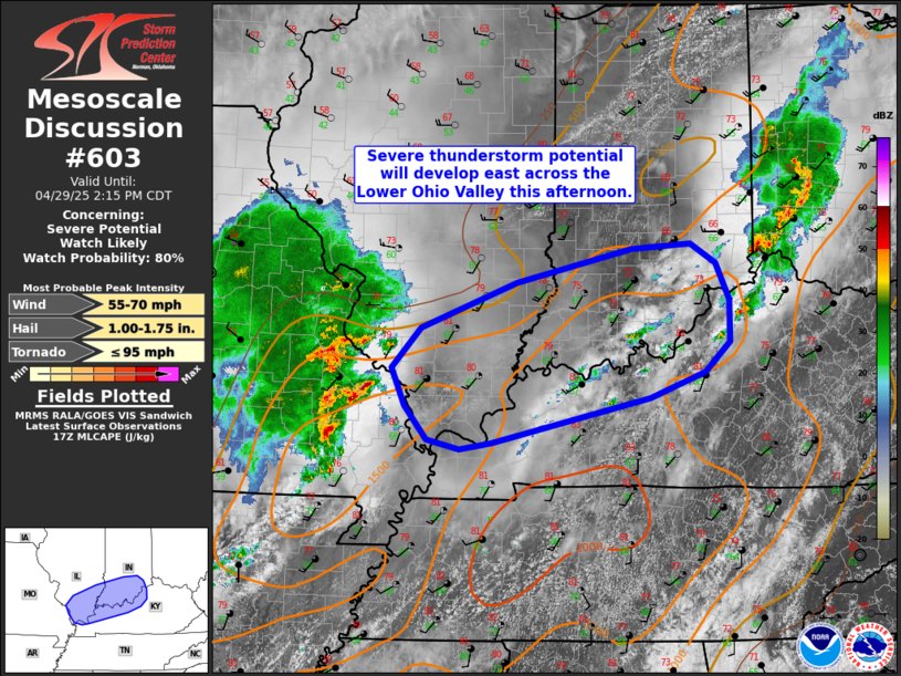
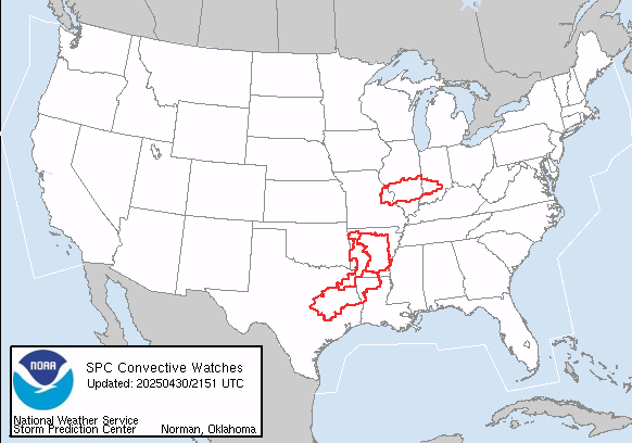
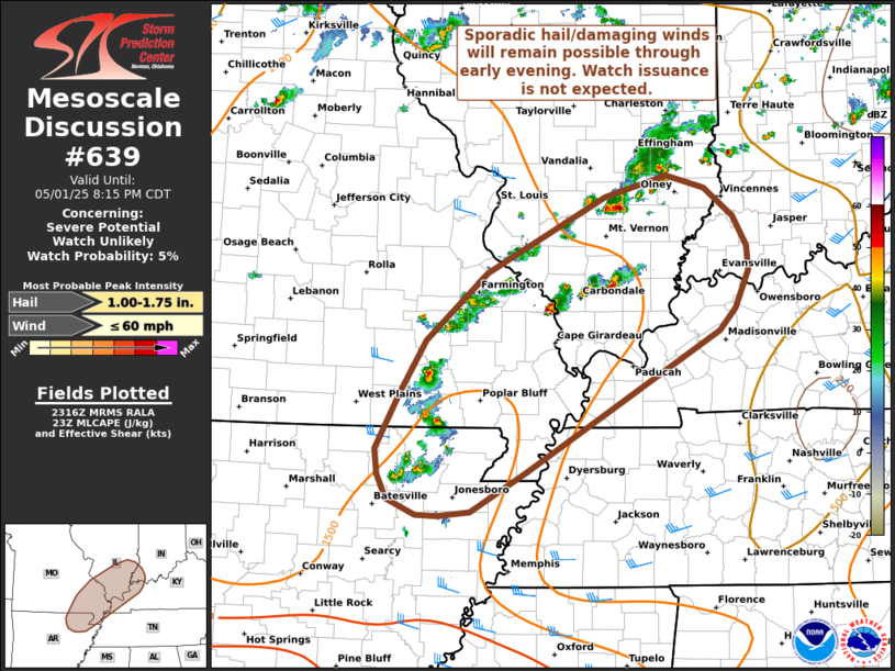
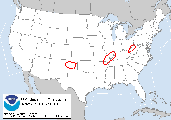
Just issued Mesoscale Discussion.
If this storm cluster manages to hold together, it could get here late this afternoon:
A severe thunderstorm watch is likely to be issued shortly for the area inside the blue box, to our west. We will likely be next in line.
https://www.spc.noaa.gov/products/md/md0600.html
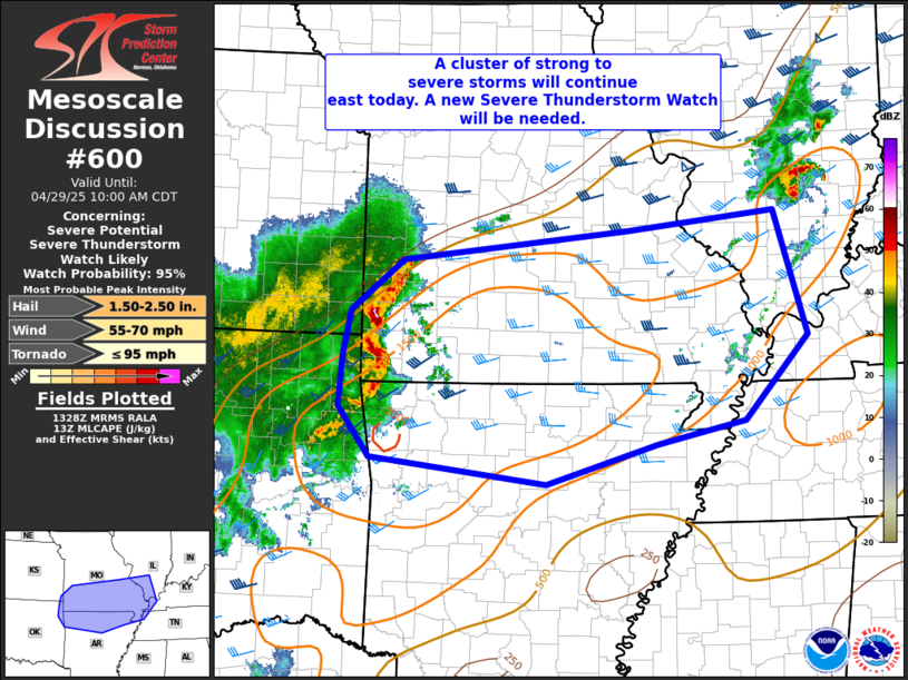
That SEVERE THUNDERSTORM watch was issued in that area to our west, in effect until 3pm.
Depending on how things develop, places to the east should be under a watch later this afternoon.
https://www.spc.noaa.gov/products/watch/ww0187.html
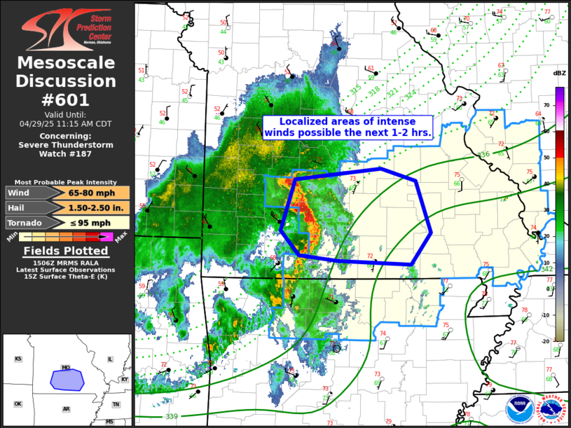
Note on the left in their highlights that for tornadoes, the risk is for the type of tornado with winds of 95 mph OR LESS! This type of weak tornado is more like a very strong thunderstorm with its damaging winds and almost never kills anybody inside of a sturdy building away from windows.
You don't want to be outside or in a mobile home in this type of storm but inside a permanent structure will provide plenty of safety, even without a basement.
https://en.wikipedia.org/wiki/Enhanced_Fujita_scale
| EFU | Unknown | No surveyable damage |
|---|---|---|
| EF0 | 65–85 mph | Light damage |
| EF1 | 86–110 mph | Moderate damage |
| EF2 | 111–135 mph | Considerable damage |
| EF3 | 136–165 mph | Severe damage |
| EF4 | 166–200 mph | Devastating damage |
| EF5 | >200 mph | Incredible damage |
+++++++++++++++
The type of tornado we could see today, if it happened would most likely be an EF0 or a low end EF1 tornado!
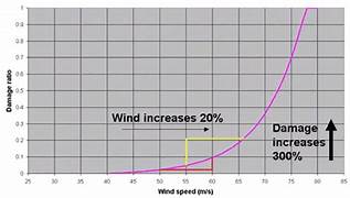
Here's the deal on wind and damage.
As wind increases the damage massively increases on an exponential scale. This applies to ALL wind.
Severe storms and hurricanes and especially tornadoes that have the strongest winds of all, which means the tornadoes with winds over 150 mph have incredible damage.
+++++++++++
+++++++++++++++++++++
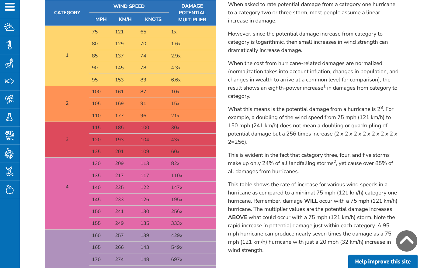
A 150 mph wind does 256X more damage than a 75 mph wind. Let's repeat that. A 150 mph wind does 256x more damage than a 75 mph wind!
Hurricane Damage Potential
https://www.noaa.gov/jetstream/tc-potential
++++++++++++
Less than 1% of tornadoes are F4 or F5 but they kill 67% of the people!
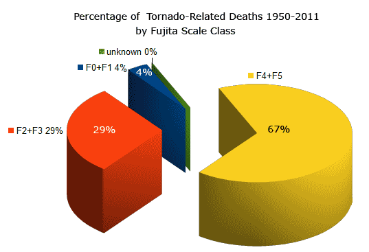
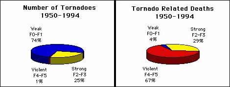
Note that the majority of tornadoes, F0 and F1= 74%(on the old scale) only killed 4% of people and they were probably outside or in a mobile home.
The F4 and F5's were just 1% but caused 67% of deaths.
Breaking news:
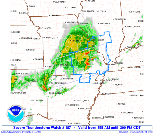
The Storm Prediction Center says an 80% chance of a Severe Thunderstorm Watch issued for us in the next hour+!!!
Again, note the type of tornado we could have is 95 mph or less with severe thunderstorm winds up to 70 mph.
https://www.spc.noaa.gov/products/md/md0603.html
The red counties are flash flood warnings NOT tornado warnings. Oranges are SEVERE THUNDERSTORM warnings..
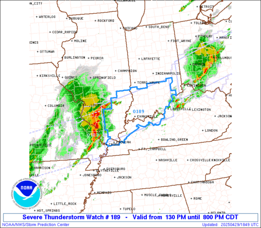
As they advised us of earlier, the Storm Prediction Center has issued the SEVERE THUNDERSTORM Watch until 8pm. An early guess is the storms will be hitting us around 5pm, possibly sooner as they are racing east An isolated weak tornado is possible.
Main threat will be severe thunderstorm wind gusts up to 75 mph! Just stay inside a permanent building when the storms are passing thru, especially if we have a warning.
https://www.spc.noaa.gov/products/watch/ww0189.html
Charge up all your electronics and other chargeable stuff NOW in case we have a power outage!
Even if the power is out briefly.
Storm reports so far today, just since 7am and its still early. 0 tornadoes.
The main threat is severe thunderstorm wind gusts as high as 75 mph.
https://www.spc.noaa.gov/climo/reports/today.html
Storms are RACING east and will be here BEFORE 5pm. Lots of severe thunderstorm warnings along the approaching line of strong/severe storms. No tornadoes but they boosted their ISOLATED tornado intensity to 85-115 mph based on observing the mesoscale convection system(MCS). Still considered weak tornadoes.
Just updated Mesoscale update:
https://www.spc.noaa.gov/products/md/md0606.html
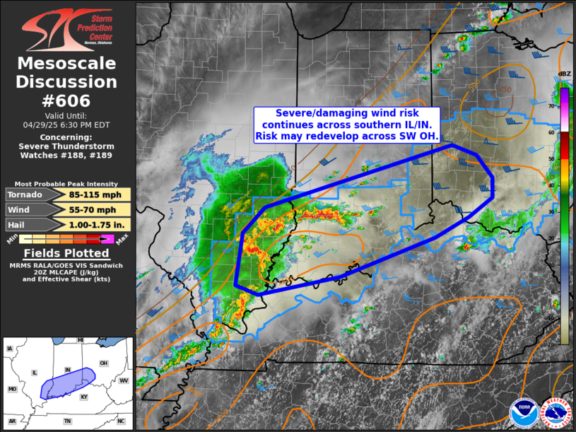
+++++++++++++++++++++++++++++++++++++++
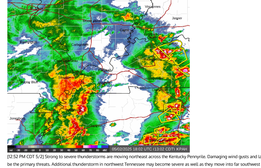
4pm: Looks to me that the part of the line coming thru Evansville HAS WEAKENED compared to earlier radar returns.
The strongest storms are passing NORTH of Evansville(winds to 66 mph just recorded at 4pm- in the county just north of Evansville), moving east at 50 mph and coming thru BEFORE 4:20pm. At least the bad part of the storm will be thru then.
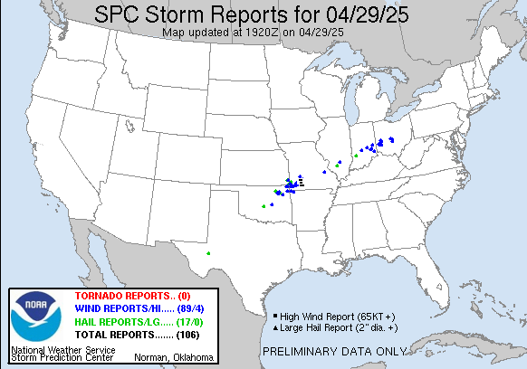
286 severe thunderstorm wind reports so far today(wind greater than 58 mph). Ohio got nailed earlier. Just 1 weak tornado.
https://www.spc.noaa.gov/climo/reports/250429_rpts.html
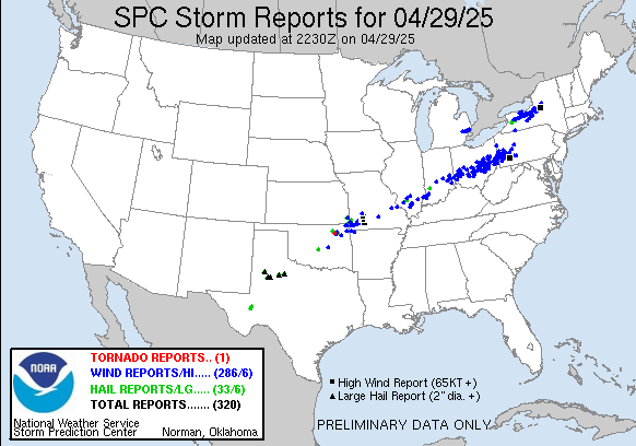
https://www.spc.noaa.gov/climo/reports/250429_rpts.html
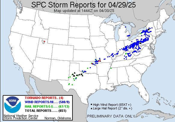
For the 24 hour period:
580 high wind reports yesterday, April 29, 2025
67 for hail
4 weak tornadoes
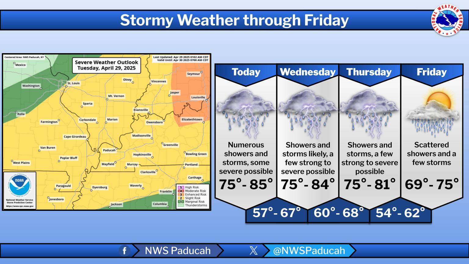
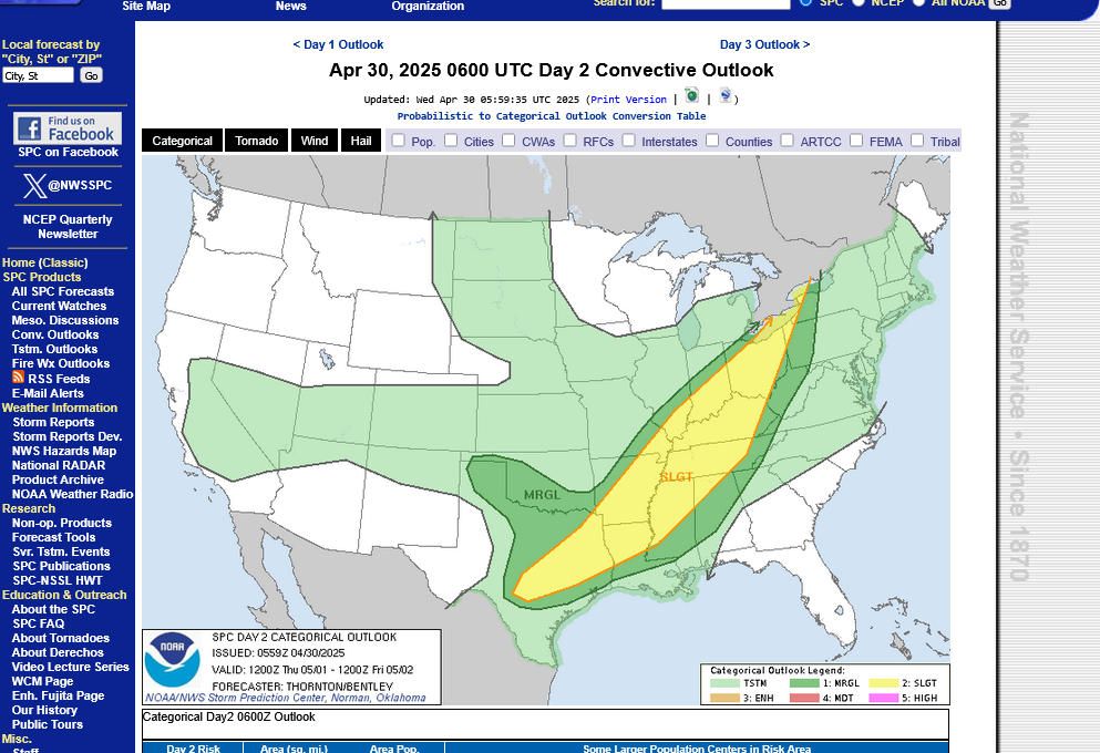
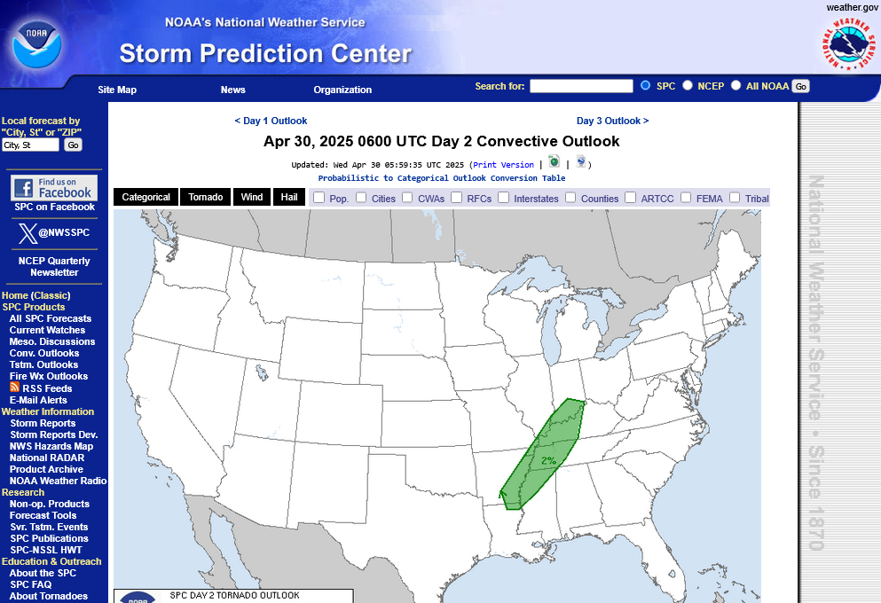
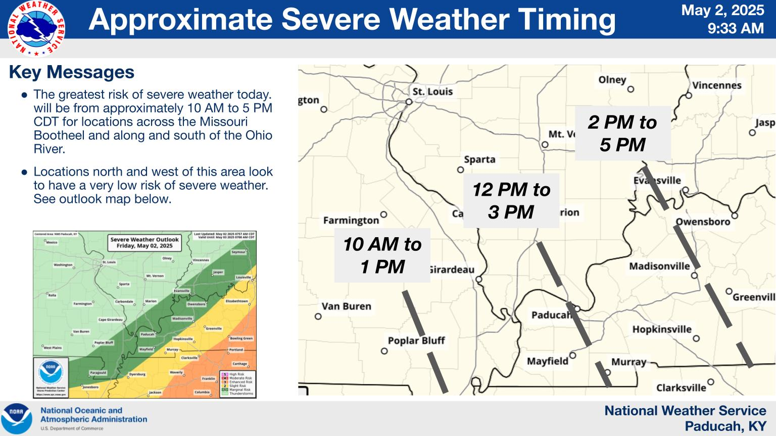
We still have a lingering SLIGHT risk of severe weather on Wednesday and especially Thursday:
Go to this link and hit your county:
Thursday's outlook below(freeze frame)
 ++++++++++++++++++++++++++
Interestingly, the chance of a weak tornado is higher today (5%) than Thursday (2%) even though the main threat, severe thunderstorm winds are HIGHEST on Thursday:
1. Tornado risk Wednesday. Chance of a tornado within 25 miles of any location.
2. Tornado risk Thursday. Chance of a tornado within 25 miles of any location.
The upper level steering winds/jet stream still have a strong south component with the main upper level trough still to our west for more than another day.
1. Wednesday morning-southwest winds
2. Thursday mid-day-south winds-trough still to the west
3. Saturday EVENING-FINALLY the upper level trough moves east!
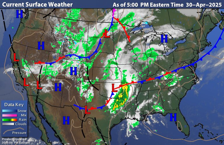
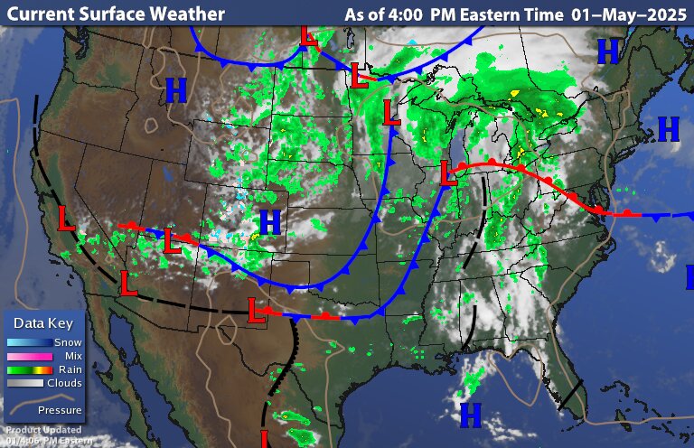
The front that went thru on Tuesday, triggering over 500 severe thunderstorm wind reports has stalled to our south and is returning as a warm front, putting us back in the very warm/humid air again later day. Then on Thursday, when a low pressure system develops to our west and increases storms again.
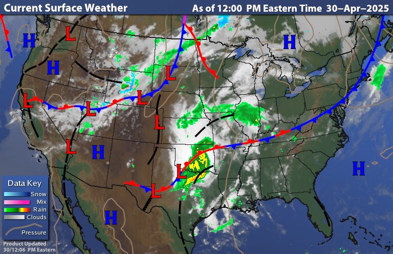
https://www.wunderground.com/maps/current-weather/mixed-surface-analysis
+++++++++++++++++++
We can see the air mass contrast on either side of that front: 80s today south of the Ohio River
Latest Surface Temperature Analysis
https://thermastor.com/dew-point-and-weather-maps/
Ryan Hall Y'all. Always great coverage.
The Storm Prediction Center is monitoring numerous locations late this afternoon:
https://www.spc.noaa.gov/products/md/
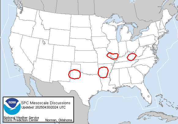
40% of a severe thunderstorm watch later this afternoon in the purple box below. Obviously a marginal situation based on what the atmosphere does which is often uncertain in some situations.
https://www.spc.noaa.gov/products/md/md0621.html
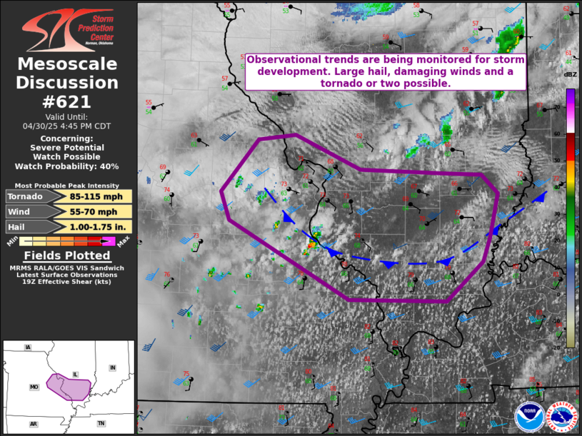
They DID issue a tornado watch for an area just north of that outlined area. Here's the latest (tornado) watch boxes. The threat appears to be NORTH of Evansville because the warm front is up there.
https://www.spc.noaa.gov/products/watch/
+++++++++++++++++++
Incorrectly drawn front. It's now well NORTH of this position as evidenced by 80's NORTH of the Ohio River. Evansville is at 83 degrees with stiff SOUTH winds at 13 mph gusting to 20 mph driving the warm front even farther north.
https://www.wunderground.com/maps/current-weather/mixed-surface-analysis
My post from earlier was accidentally deleted.
A weak trough with slightly lower dew points and temperatures went thru, along with clouds so the Storm Prediction Center has shifted the risk of severe storms farther east.
https://www.wunderground.com/maps/current-weather/mixed-surface-analysis
https://www.marketforum.com/forum/topic/83844/#83845
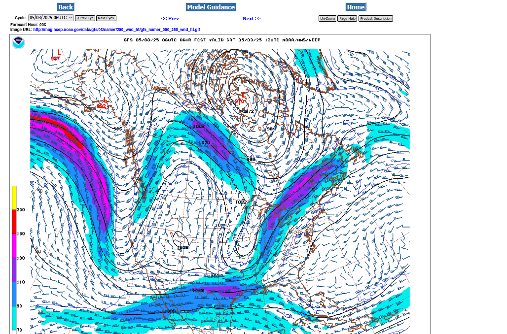
I'm going to have to disagree with them a tiny bit, based on the jet stream below for this afternoon. We're still WELL east of the upper level trough and in the right rear quadrant of the jet stream with southern flow at 250 mb. This produces divergence aloft that results in lift at the surface to replace the air diverging aloft.
So I think that we still have a SLIGHT risk of any storms this afternoon turning severe. The main risk will be if the clouds break up so we get enough sun to warm and destabilize the surface and see any sort of convection develop.
Maybe nothing will happen and the difference is small.
https://www.theweatherprediction.com/habyhints2/601/
HABYTIME MINI LECTURE 26:
QUADRANTING A JET STREAK
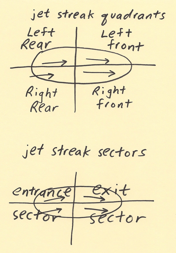
The purpose of quadranting a jet streak is to find where the regions of lifting and sinking air are located. Upper level divergence contributes to lifting air while upper level convergence contributes to sinking air. When reading about “upper level divergence” in a forecast discussion, jet streak divergence is one contributing factor to upper level divergence and thus rising air. Rising air enhances precipitation chances and storm chances. The regions of upper level divergence (rising air) are in the Right Rear quadrant and the Left Front quadrant while the regions of upper level convergence (sinking air) are in the Left Rear and Right Front quadrant. The diagram below shows the quadrants of a jet streak and a path that a parcel of air can take as it moves through the jet streak. Notice the parcel of air shifts from the RR and into the LR quadrant before shifting from the LF and into the RF quadrant. The significance of this will be explained next since this is what causes the divergence and convergence quadrants within a jet streak.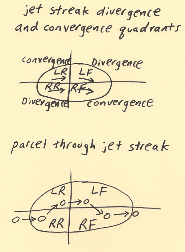
A parcel of air enters the jet streak in the entrance sector at position 1 for example in the diagram below. As the parcel moves toward the jet core, the parcel is accelerating due to the higher pressure gradient. The Pressure Gradient Force (PGF) acts very quickly on the parcel of air but the Coriolis (f) acts slowly. Thus, the PGF overpowers the Coriolis force and the parcel deviates more in the direction of the PGF (position 2). A longer vector of PGF at position 2 as compared to the Coriolis is used to indicate the PGF is stronger than the Coriolis. Between position 2 and position 3, the Coriolis is coming into adjustment with the PGF and the parcel deviation of motion stops. However, when the parcel starts coming out of the jet core at position 3 and the wind speeds slow (and thus PGF weakens and the parcel decelerates), the PGF rapidly reduces while the Coriolis is slow to adjust. The temporarily stronger Coriolis causes the parcel to deviate toward the direction of the stronger Coriolis (at position 4). The Coriolis adjustment completes between position 4 and position 5. At position 5, the parcel is once again in balance between the PGF and Coriolis forces. In the right rear quadrant (from position 1 to 2), there is an evacuation of mass as more air mass piles into the left rear quadrant. This deficit of air helps pull up air from below (thus rising air in right rear quadrant). In the left front quadrant (from position 3 to 4), there is also an evacuation of mass more air mass piles into the right front quadrant. This deficit of air helps pull up air from below (thus rising air in the left front quadrant).
+++++++++++++++
THE 300 / 200 MB CHART
https://www.weather.gov/source/zhu/ZHU_Training_Page/winds/JetStream_Stuff/300_200_chart.htm
++++++++++++++
For those that want to understand meteorology, Jeff has THE BEST tutorials:
| HABY'S WEATHER FORECASTING HINTS |

The trough that moved thru earlier has ushered in some drier air and also slightly cooler but the main cold front is still farther west and also a reinforcement behind that rotating around this upper level system.
https://www.wunderground.com/maps/current-weather/mixed-surface-analysis
That approaching front it triggering some shwrs-t'shwrs that are farther north closer to the stronger jet stream dynamics. An isolated severe storm is possible up there but the drier, cooler air blowing in today has reduced the risk of severe storms to very low.
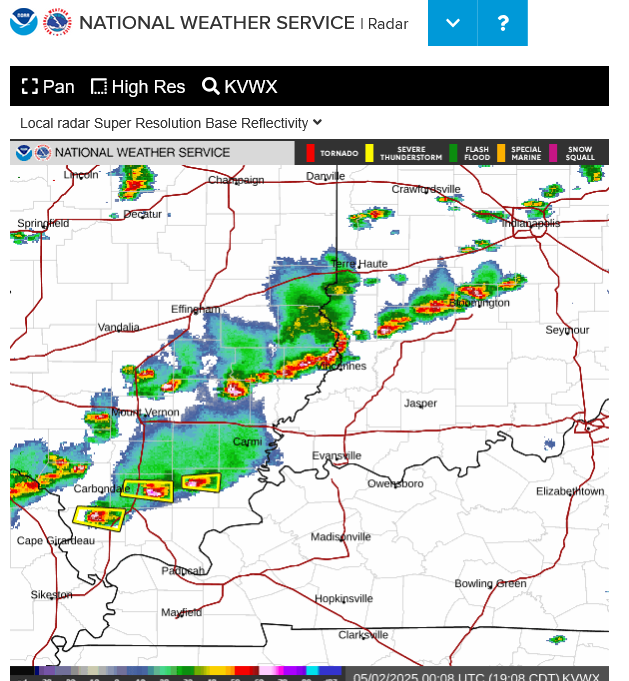
https://radar.weather.gov/station/kvwx/standard
1pm radar image below:
All the severe storms with this waves are staying staying just southeast of Evansville'
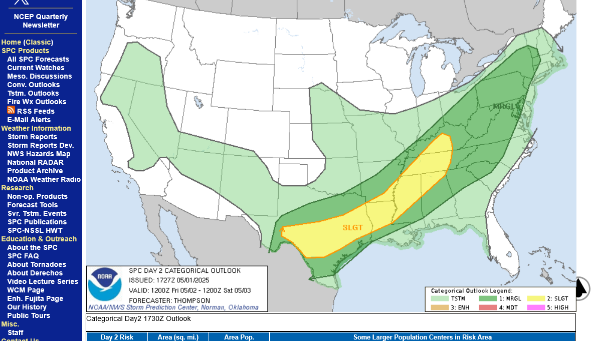
This same extremely slow moving upper level system will bring back a marginal(to possibly slight) severe storm risk on Friday as an impulse/perturbation moves thru the flow. This SLIGHT risk will be mostly for wind and hail, not tornadoes.
https://www.spc.noaa.gov/products/outlook/day2otlk.html
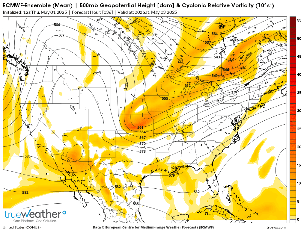
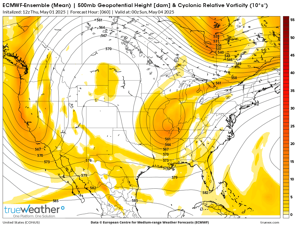
These are 500 mb maps. Yellow/brown is vorticity(spin) in the atmosphere which is associated with lift. This was from the last 12z European Ensemble model.
1. Friday afternoon-little spoke of vorticity tracking thru the southwest flow ahead of the upper level trough
2. Saturday afternoon-Upper level trough deepens into a cut off low that causes it to sloooooow down. Centered in southeast Missouri. Continued chance for showers but the much cooler atmosphere will be stabilized. NOT a good pattern for the KY Derby in Louisville.
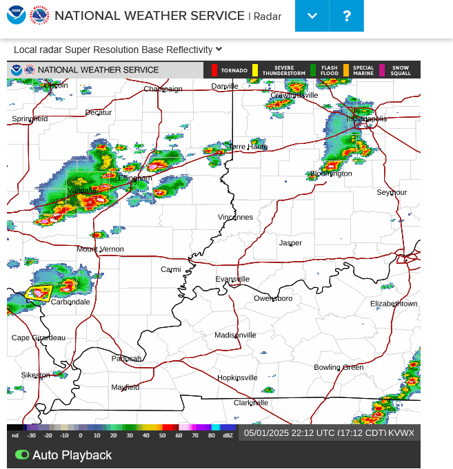
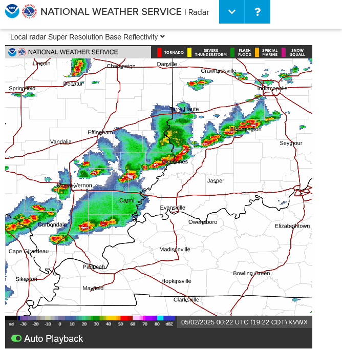
5:15pm frame of the radar shows 1 severe thunderstorm in western IL with no threat to Evansville.
https://radar.weather.gov/station/kvwx/standard
3 more severe thunderstorm warnings on storms headed towards Evansville but they will likely die out with the sun setting.
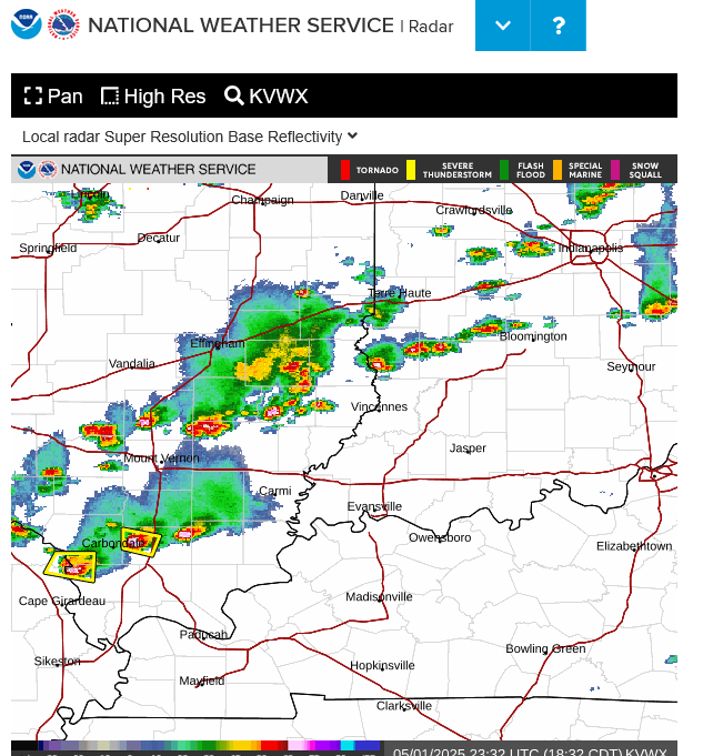
More warnings after 7pm. Will the storms die now?
They weakened, here are 7:20pm. No longer severe. Almost trying to congeal into a line.
The Storm Prediction Center was surprised by the storms and put out a mesoscale discussion on them an hour ago........indicating a 5% chance of a watch which is the lowest % chance for a watch in a mesoscale discussion ever.
These storms intensified because of that area being in the right rear quadrant of the jet stream, as explained at the link below!
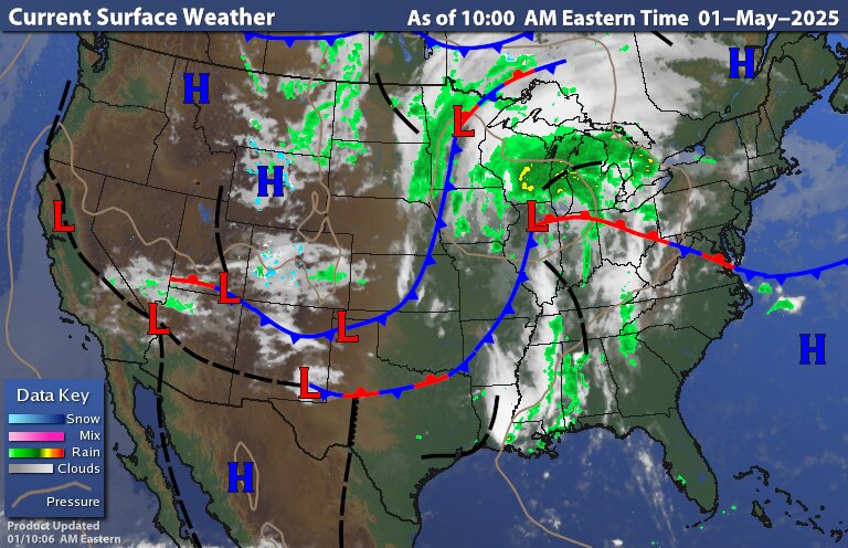
By metmike - May 1, 2025, 11:34 a.m.
++++++++++++++++++
https://www.spc.noaa.gov/products/md/md0639.html
The upper level spoke of vorticity(perturbation) mentioned yesterday
https://www.marketforum.com/forum/topic/111519/#111598
is setting off a big wave of t-storms right now that are moving northeast in the upper level flow.
Some of these storms will be severe this afternoon, mainly in the outlined areas below by the Storm Prediction Center southeast of Evansville but an isolated strong storm can't be ruled out farther north.
Go to this link and hit your county:
Live radar below
1pm radar image below: All the severe storms staying southeast of Evansville with this wave. Another wave is entering southwest KY right now:
The early afternoon storms coming thru KY stabilized the air mass. No more severe weather risk today.


The pattern described earlier this week: https://www.marketforum.com/forum/topic/111519/#111598 is happening this weekend.
The main, northern branch of the jet stream has retreated north into Canada, with the southern branch being much farther south. However, with this sudden retreat northward, the main jet stream left behind the current upper level trough, which has caused it to "cut off" and develop into a system with its own self sustaining flows, spinning around without any steering currents from jet streams that transport/move weather systems in the main flow.
As a result, it's going to take a couple of days for this system to gradually drift out of here.
Early next week, the southern branch of the jet stream will finally bump it northeastward.
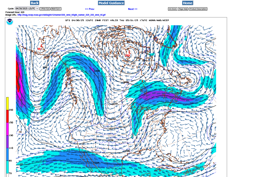
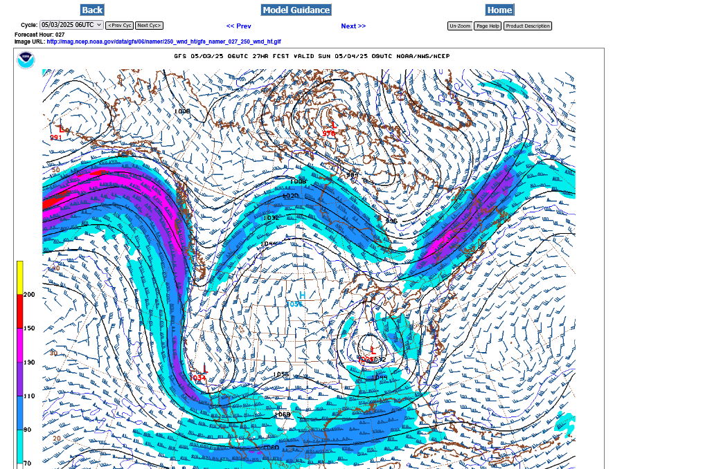
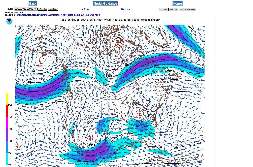
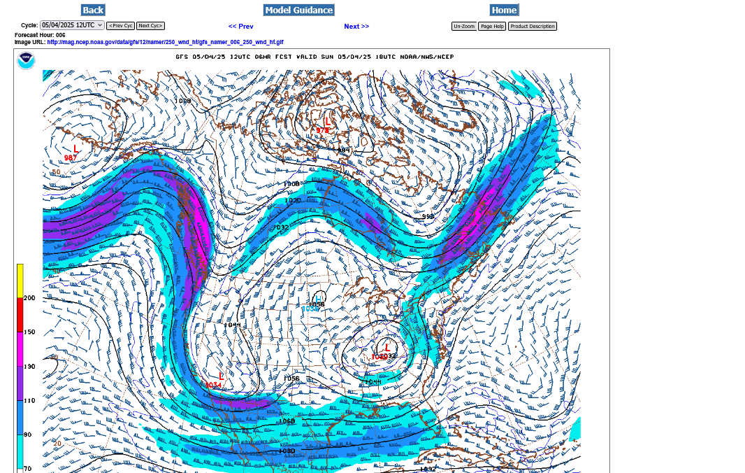
1. Current jet stream at 250 mb-upper level trough still to our west
2. 250 mb map for very early Sunday morning-cut off low on top of us
3. 250 mb for very early Tuesday morning-low finally lifted out
As of early Saturday, note that the movement of the rain is STILL from southwest to northeast, telling us that the cut off low is still to the west of us.
We can see where the upper level low and its counterclockwise flow has slowly moved to just after noon on Sunday by looking at the motion on the radar loop from Indianapolis, IN.
The rain is moving from east to west across the northern half of IN.
From north to south in southwest IN.
From southwest to northeast in central KY
From southeast to northwest in OH.
The low is just north of Louisville!

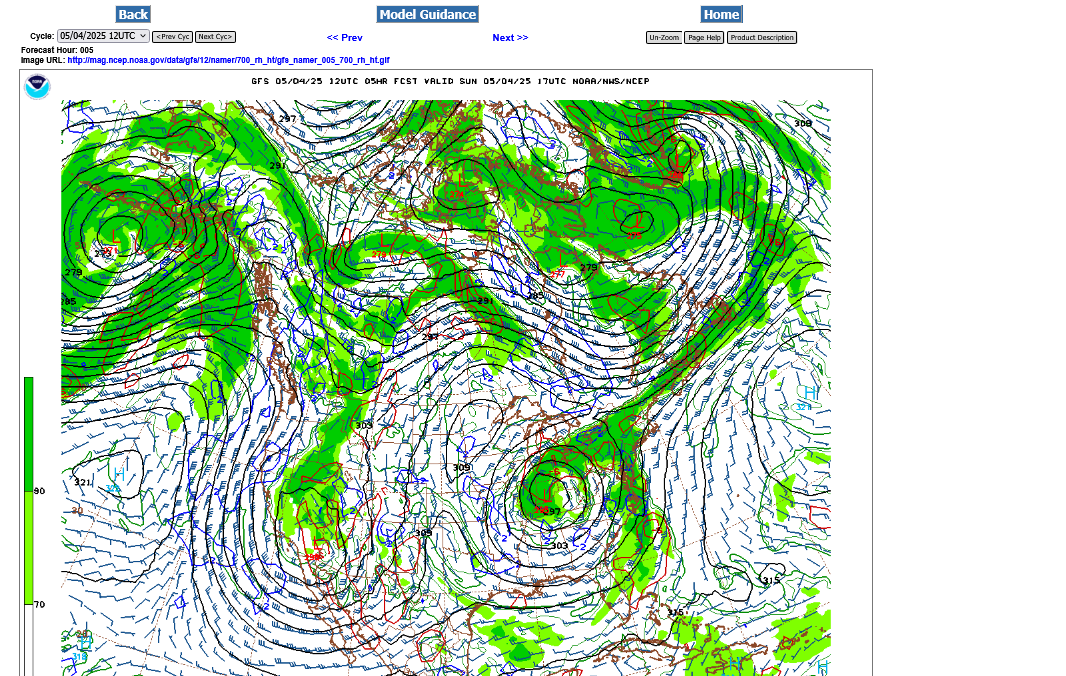
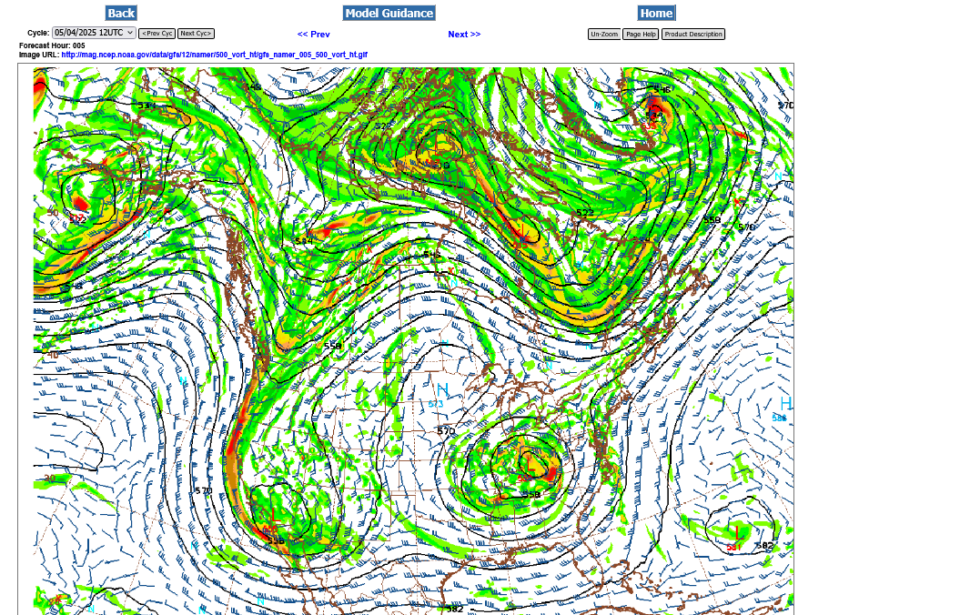
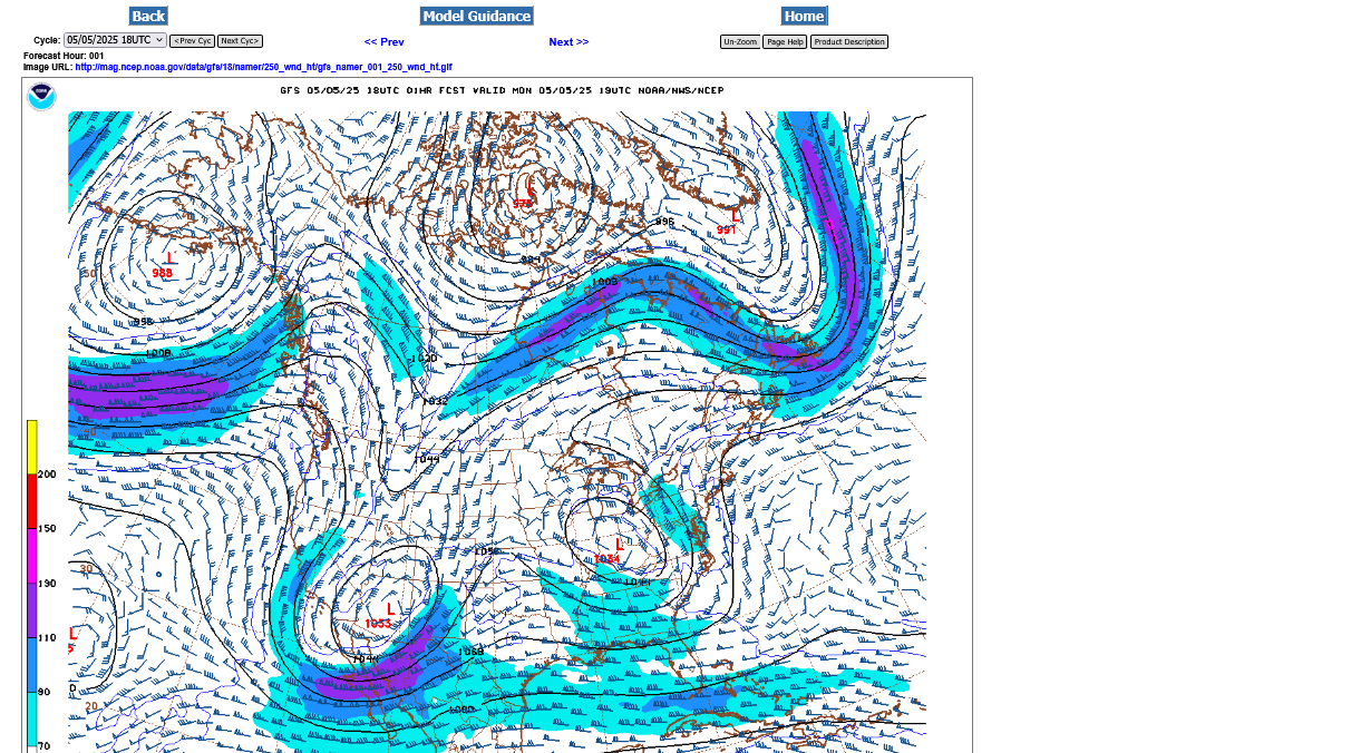
1. 700 mb low below:
2. 500 mb
3. 250 mb
Select a tutorial below or scroll down...
UPPER LEVEL LOWS
https://www.theweatherprediction.com/habyhints/2/
https://www.theweatherprediction.com/habyhints3/815/
https://www.theweatherprediction.com/habyhints/200/
| HABY'S WEATHER FORECASTING HINTS |
| [--MAIN HOME--] [--HABY HINTS FACEBOOK PAGE--] |
Cutoff lows tend to move EVEN SLOWER than what the models and forecasts predict.
Here it is on Monday afternoon on the 250 mb map. Still southwest of Cincinnati.
Rain is moving west to east underneath the low along the IN/KY border but east to west on top the low in northern IN.
The low is in far southeast IN. It will finally lift out on Tuesday!
Get all the constantly updated weather here:
Eric is the best!