
The next round of severe weather is coming up. Looks like a major outbreak tomorrow, Friday May 16, 2025!
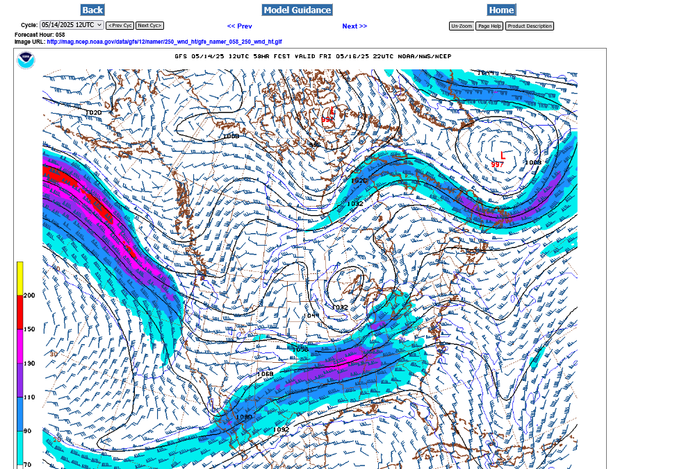
The 250 mb jet stream forecast from the last 12z GFS model below shows a pretty potent jet stream that includes an embedded 150 mph jet max. This will cause strong lift and the wind sheer/spin favorable for tornadoes.
This is the Friday afternoon forecast below:
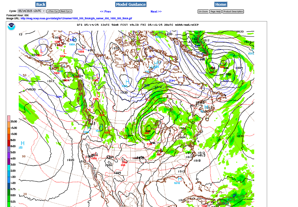
A surface wave along an approaching cold front will increase the lift ahead of the front. There is the potential for a severe weather outbreak in its advance that includes the chance of strong tornadoes.
Very warm, humid and unstable air will be in place ahead of the front.
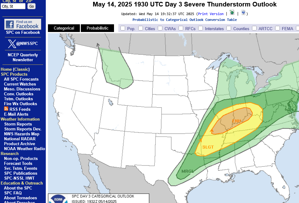
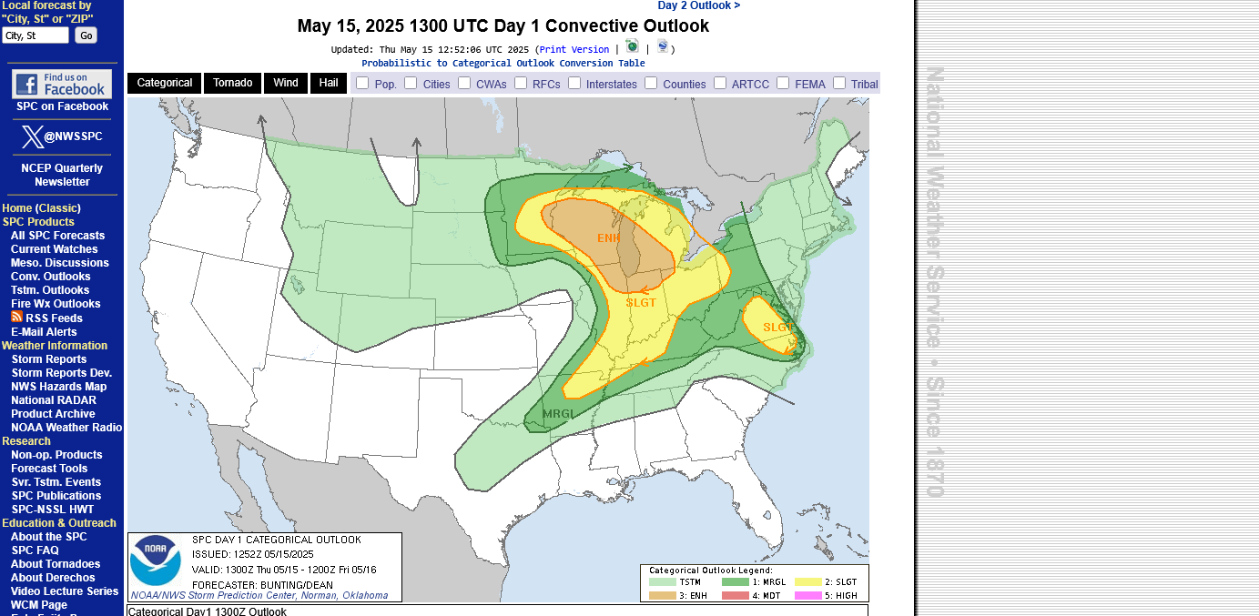
Severe weather risk on Thursday:
https://www.spc.noaa.gov/products/outlook/day1otlk.html
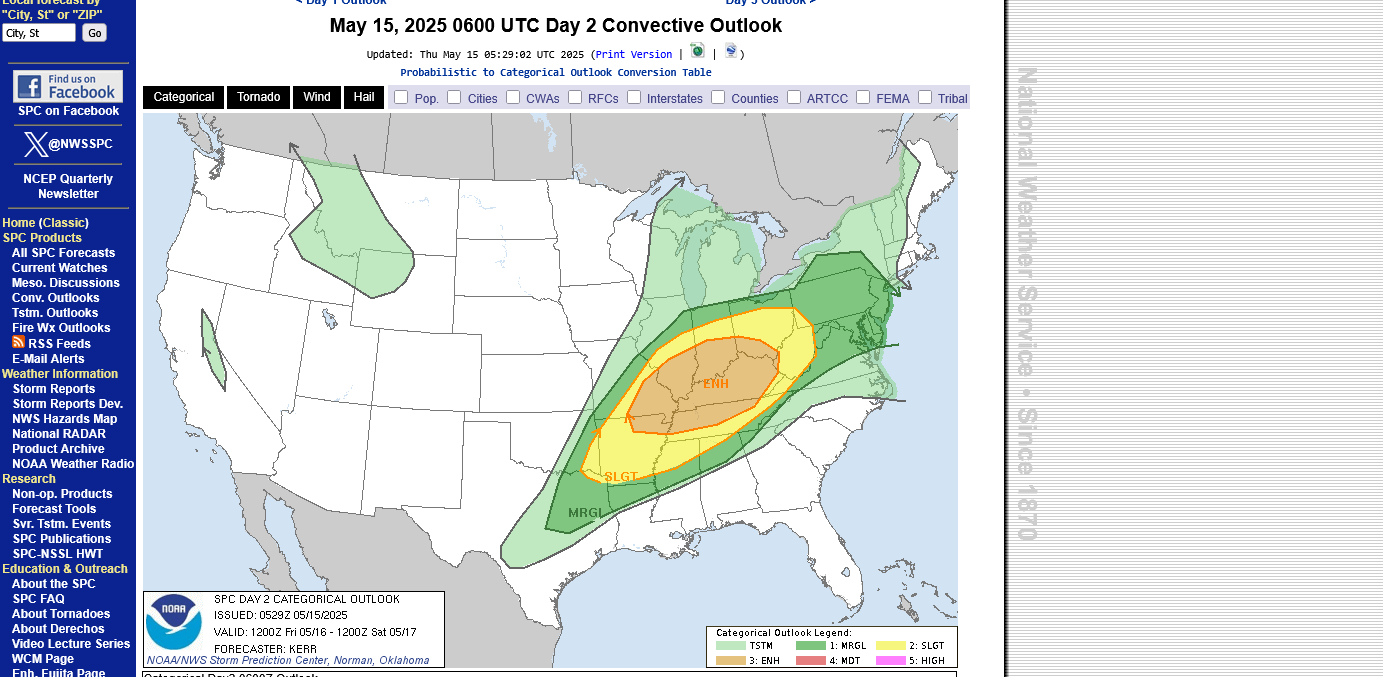
https://www.spc.noaa.gov/products/outlook/day2otlk.html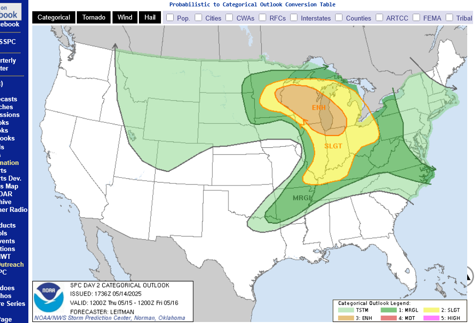
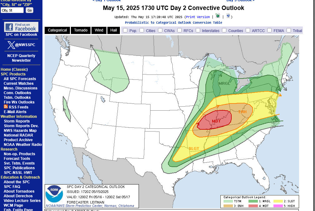
Severe weather risk on Friday:
There is a GOOD chance that the Storm Prediction Center could bump this up from level 3 out of 5(enhanced) to a level 4(moderate):
https://www.spc.noaa.gov/products/outlook/day1otlk.html
https://www.spc.noaa.gov/products/outlook/day2otlk.html
1. Thursday/Thursday Night outlook
2. Friday-risk could be elevated to moderate
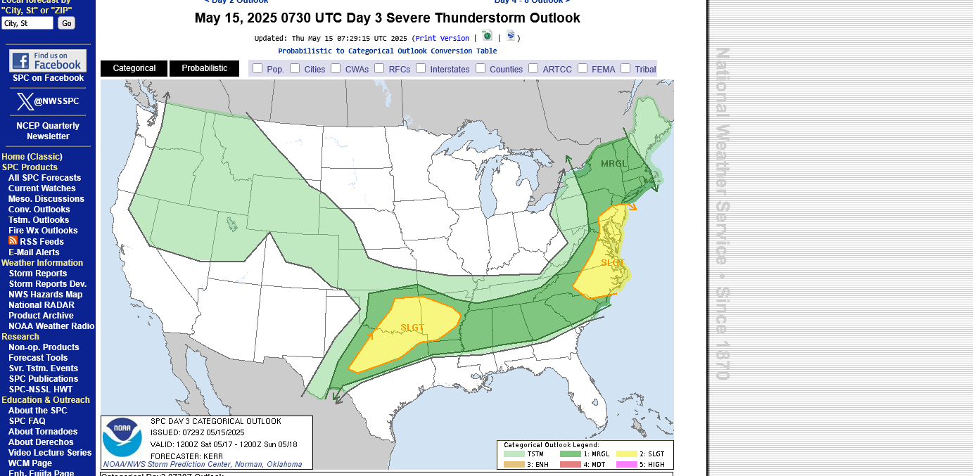
3. Saturday
Tracking the storms!

https://www.wunderground.com/maps/radar/current

Winter Weather Forecasts
https://www.wpc.ncep.noaa.gov/wwd/winter_wx.shtml
+++++++++++++++
Current Hazards at the link below.
For your NWS and county, go to the link below.
Then you can hit any spot on the map, including where you live and it will go to that NWS with all the comprehensive local weather information for that/your county.

New radar product below
Go to: "Select View" then "Local Radar"
Hit the purple circle to see that local radar site
+++++++++++++++++++++++
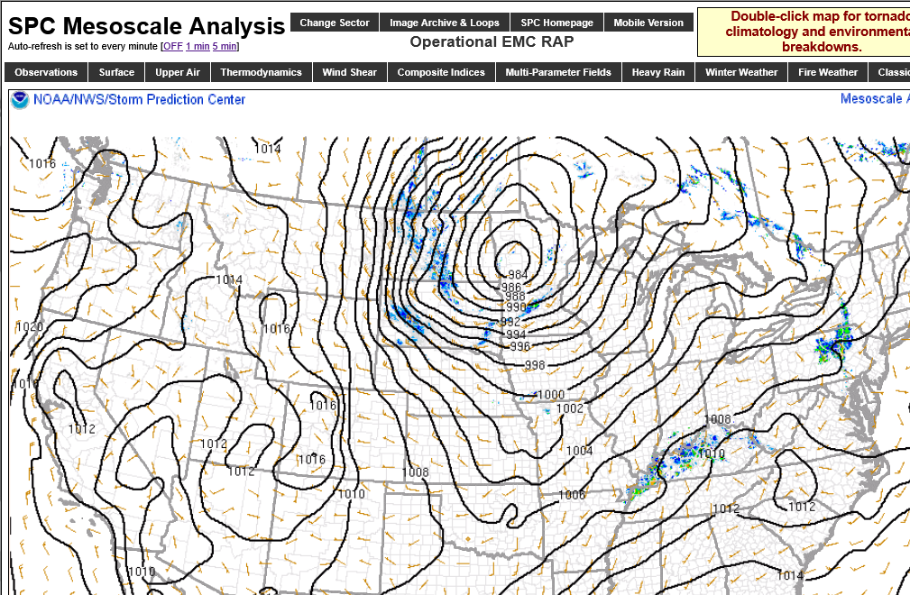
This link below provides some great data. After going to the link, hit "Mesoanalysis" then, the center of any box for the area that you want, then go to observation on the far left, then surface observations to get constantly updated surface observations or hit another of the dozens of choices.
 |
Freeze frame of isobars just before 9am Friday morning. DEEP low in Minnesota.
https://www.spc.noaa.gov/exper/mesoanalysis/new/viewsector.php?sector=19&parm=pmsl
Current Conditions below updated every few minutes.
UPPER MIDWEST
https://www.spc.noaa.gov/exper/mesoanalysis/new/viewsector.php?sector=13#


https://www.spc.noaa.gov/exper/mesoanalysis/new/viewsector.php?sector=13#

LOWER MIDWEST
https://www.spc.noaa.gov/exper/mesoanalysis/new/viewsector.php?sector=20

https://www.spc.noaa.gov/exper/mesoanalysis/new/viewsector.php?sector=20#

https://www.spc.noaa.gov/exper/mesoanalysis/new/viewsector.php?sector=20# 
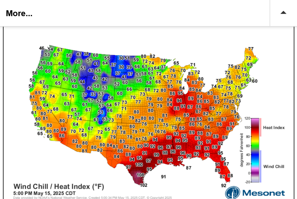
It's drawing up warm/humid air ahead of it with cold/dry air to the north. Temperature contrasts/boundaries feed storms and provide lifting/triggering mechanisms.
The first image is at 5pm Eastern, Thursday 5-15-25. It shows 90's in central IL on the hot/humid side of the storm(in the form of the heat index) and 30's in western ND on the cold/windy/dry side(in the form of the wind chill index).
The 2nd one is updated every hour.
https://thermastor.com/dew-point-and-weather-maps/

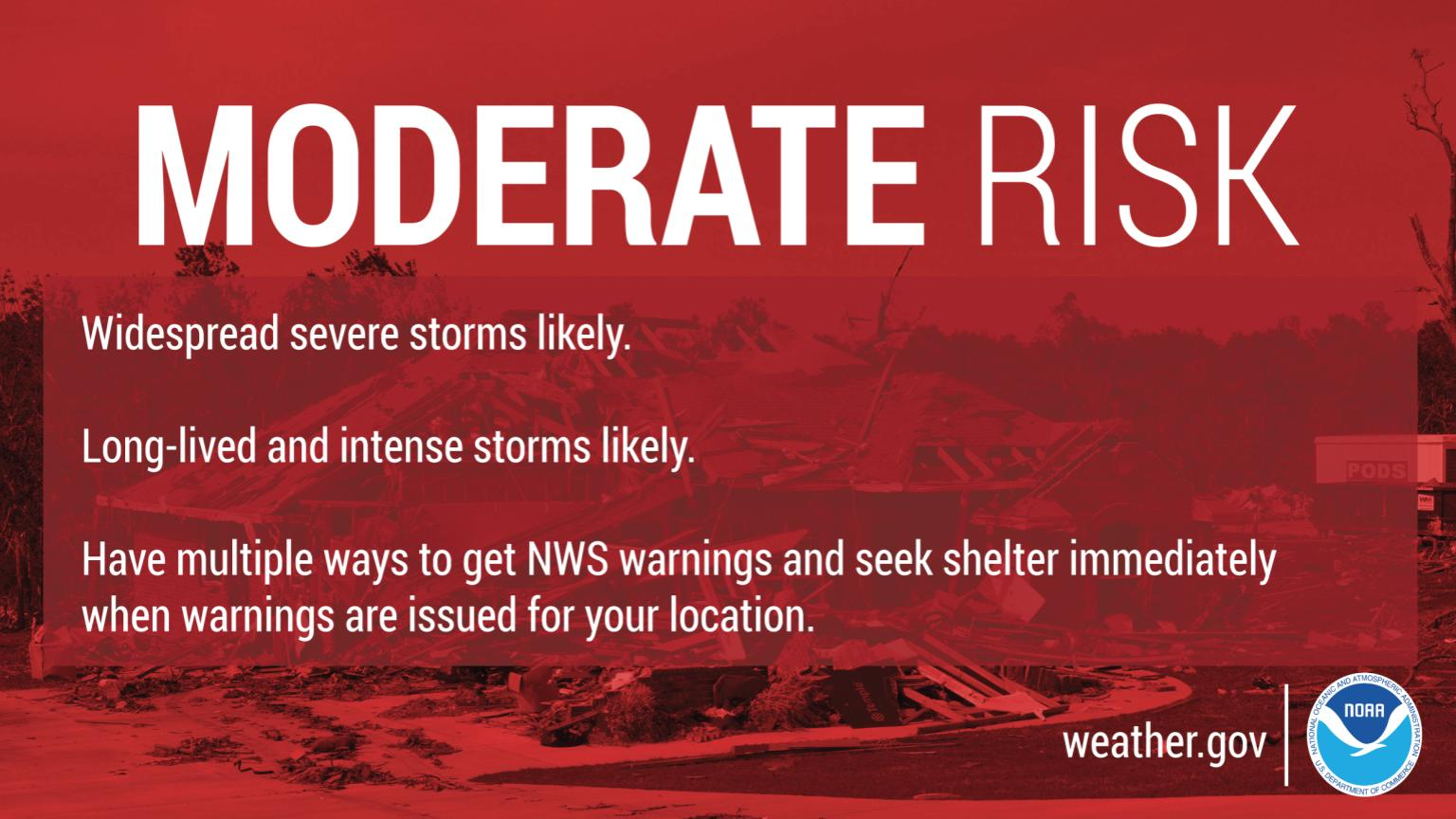
As I speculated about yesterday, the Storm Prediction Center has bumped up our risk to a moderate, level 4 out of 5 for Friday:
https://www.spc.noaa.gov/products/outlook/day2otlk.html
This is a freeze frame below:
Local NWS for Evansville IN area.
National Weather Service Paducah, KY area of responsibility:


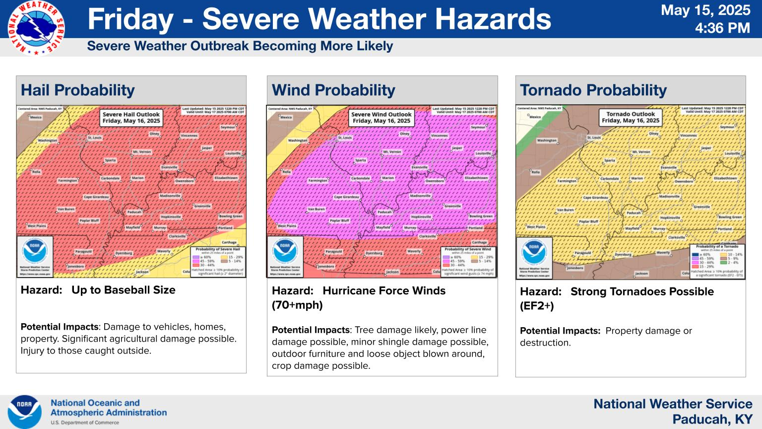
The type of tornado possible on Friday will be EF2+. The type that can do considerable damage. The good thing is that this will hit DURING THE DAY and not at night.
Even with a moderate risk, the overall risk is very small. However, it's for a very small risk of especially dangerous type storms.
https://en.wikipedia.org/wiki/Enhanced_Fujita_scale
| EFU | Unknown | No surveyable damage |
|---|---|---|
| EF0 | 65–85 mph | Light damage |
| EF1 | 86–110 mph | Moderate damage |
| EF2 | 111–135 mph | Considerable damage |
| EF3 | 136–165 mph | Severe damage |
| EF4 | 166–200 mph | Devastating damage |
| EF5 | >200 mph | Incredible damage |
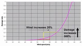
Here's the deal on wind and damage.
As wind increases the damage massively increases on an exponential scale. This applies to ALL wind.
Severe storms and hurricanes and especially tornadoes that have the strongest winds of all, which means the tornadoes with winds over 150 mph have incredible damage.
+++++++++++
+++++++++++++++++++++
A 150 mph wind does 256X more damage than a 75 mph wind. Let's repeat that. A 150 mph wind does 256x more damage than a 75 mph wind!
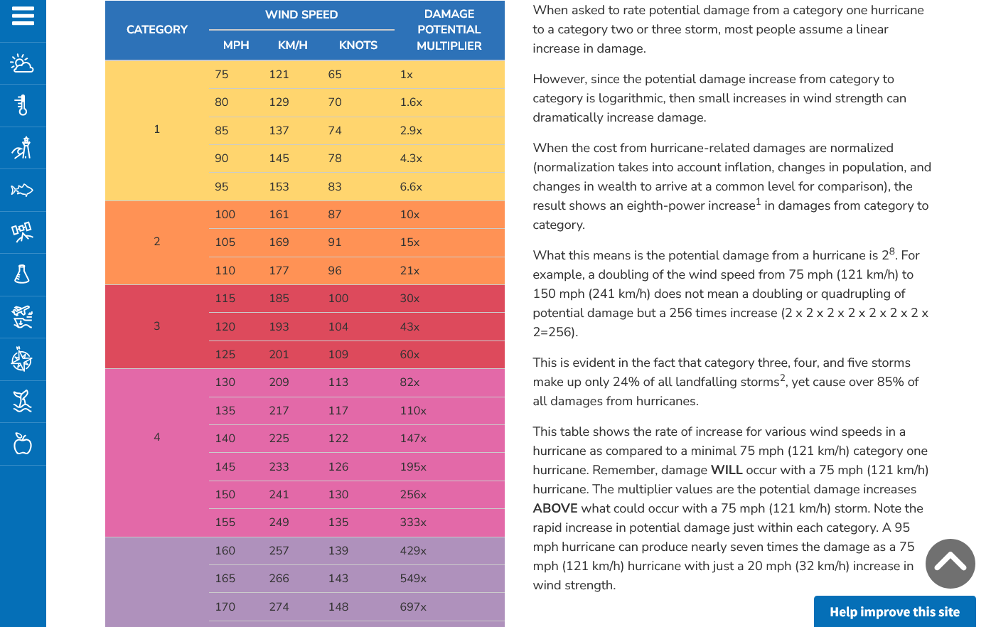
Hurricane Damage Potential
https://www.noaa.gov/jetstream/tc-potential
++++++++++++
Less than 1% of tornadoes are F4 or F5 but they kill 67% of the people!
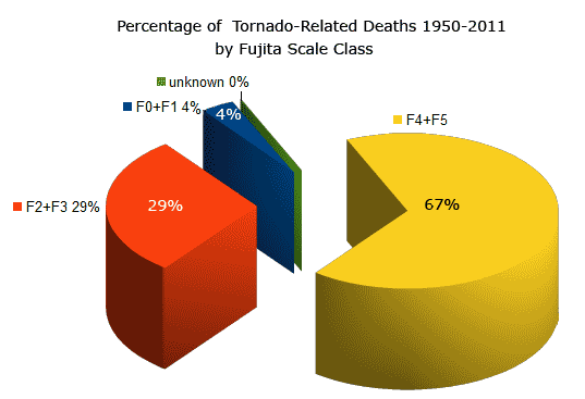
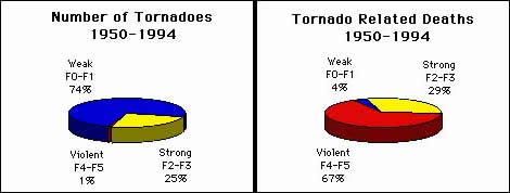
Note that the majority of tornadoes, F0 and F1= 74%(on the old scale) only killed 4% of people and they were probably outside or in a mobile home.
The F4 and F5's were just 1% but caused 67% of deaths.
+++++++++++++++++++
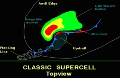
https://www.weather.gov/ama/supercell
++++++++++++
Excellent presentation at this link below that describes the different types of tornadoes and the damage they cause. Keep in mind that the EF4 and EF5 tornadoes are extremely rare. Less than 1% of tornadoes are this strong. Today is one of those rare days.
The EF4 and EF5 tornadoes will usually have the HIGH, level 5 risk earlier that day.
Mike Simon Tornado Damage Intensity; Enhanced Fujita Scale
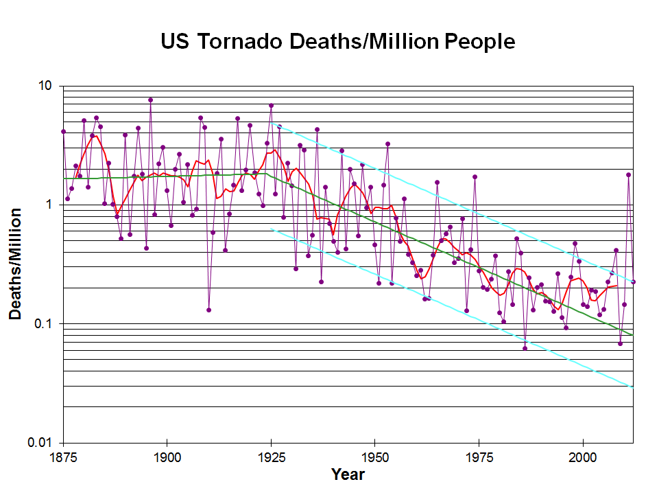
Knowing that a violent tornado may be headed towards your location, thanks to technology and being in a safe place is the main reason for this graph to show plunging fatalities from violent tornadoes. That 1 spike near the end was from the Joplin MO, tornado of 2011.
Note the drop that coincided with the start of the technology(radars and radio/tv communications, including weather radios).
The graph below is logarithmic. Tornado deaths today are around 10% what they were 100 years ago.
https://inside.nssl.noaa.gov/nsslnews/2009/03/us-annual-tornado-death-tolls-1875-present/
+++++++++++++++++++++++++++++
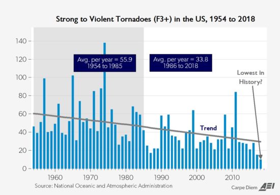
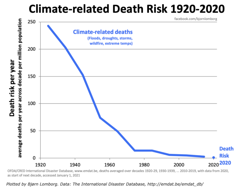
Another important authentic science/meteorology item is that climate change has REDUCED the number of violent tornadoes and tornado deaths.
https://www.marketforum.com/forum/topic/110407/#110432
Re: Re: Severe weather #2 May 7-8, 2024
By metmike - May 10, 2024, 12:11 a.m.
Why is this?
Meteorology 101 tells us what happens when the planet sees the temperature of the highest latitudes (coldest places, especially coldest time of year) warmed up the most. This is beneficial warming! Reduced meridional temperature gradient..........weaker cold fronts and jet streams.
Weather becomes LESS extreme in several realms!
+++++++++++++++++++
Put on your severe weather seat belts and enjoy the enlightenment and benefits of technology!!!
Don't be scared........be prepared!!!!
Regardless of the stats above, on days like Friday, we have the opportunity to save lives by going to our safest place in the event that a tornado WARNING is issued for your county. Most tornado warnings are for weak tornadoes, less than 110 mph that don't hurt anybody. Friday's tornadoes could have 120+ mph winds.
Have your battery powered electronics charged up in case of a power outage!
Don't be scared...........be prepared!
We've had dozens of severe weather events like this(some with a HIGH, 5 out of 5 risk) in just the last decade. Violent tornadoes have actually DECREASED the past 40 years.
The highest risk will be later Friday afternoon. Low tornado risk Friday morning(and mostly south of Evansville).
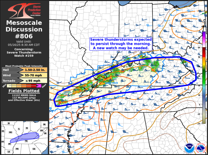
SEVERE THUNDERSTORM Watch until 9am, (weak) tornado risk low right now. Storms mainly in KY. Main risk this morning in the watch box is for large hail and a wind gust to 70 mph.
Additional watches coming today, with tornadoes possible this afternoon.
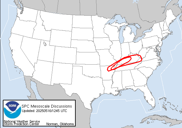
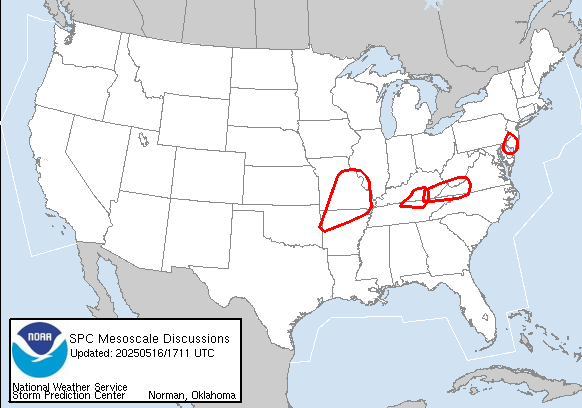
https://www.spc.noaa.gov/products/md/md0806.html
The Storm Prediction Center is having a temporary issue with their mesoscale discussions links that should be resolved quickly
https://www.spc.noaa.gov/products/md/
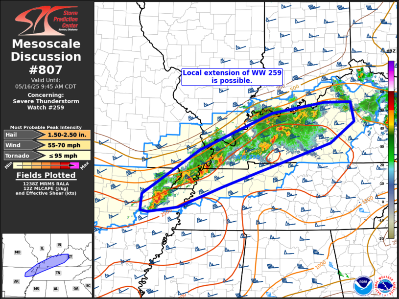
I think its fixed:
https://www.spc.noaa.gov/products/md/md0807.html
Latest here:
Stalled front along the Ohio River. When the wave farther to the west gets closer(well into the afternoon), it could trigger widespread storms. It might give the stalled front a push northward as it gets close.
Any clouds/rain ahead of it will help a bit to stabilize the environment but this event will NOT be driven exclusively from daytime heating.
https://www.wunderground.com/maps/current-weather/mixed-surface-analysis

The kids should be home from school this afternoon before the severe weather threatens.
Its storming here in Valley Forge,a few miles from Villanova, we need the Pope to save us here in Penna!
Good one, Mike!
The last pope wasn't able to save us from the fake climate crisis by getting on board with the people telling us that we can control the weather(his pontifical academy of sciences in cahoots with the UN) but maybe this one has greater powers

The Climate Crisis is upon us. It will get lot worse over the next few decades as planetary heating shoots past 1.5C by early 2030s.
https://www.pas.va/en/events/2024/climate_resilience.html
++++++++++++++
By the way, I loved and cherished the last pope even though he was full of doo doo on this topic.
RIP Pope Francis!
Started by metmike - April 21, 2025, 11:58 a.m.
https://www.marketforum.com/forum/topic/111361/
This is the area where the severe storms will first erupt this afternoon, before moving eastward.
https://www.spc.noaa.gov/products/md/
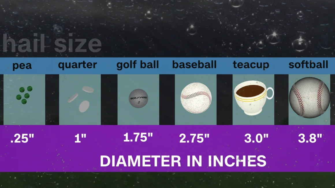
Note the risk of tornadoes with winds of up to 150 mph as well as thunderstorm wind gusts up to 90mph and hail to 4.25 inches(soft ball size)!!!!
In case a storm like this results in a warning for your county.........be ready to go to your safe spot later today.
https://www.spc.noaa.gov/products/md/md0813.html
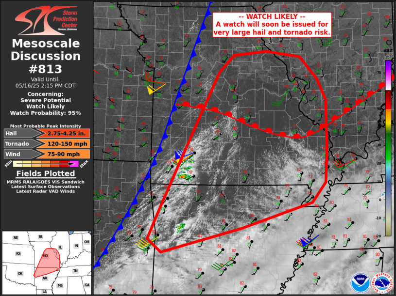
https://www.cnn.com/2023/04/26/weather/hail-formation-xpn-scn/index.html
++++++++++++++++
As they told us earlier in the mesoscale discussion, the tornado watch was issued for that area until 7pm. That suggests the severe storms will be east of that area just AFTER 7pm, which is when they will threaten western IN. That time frame could change based on how fast the storms move, once they form.
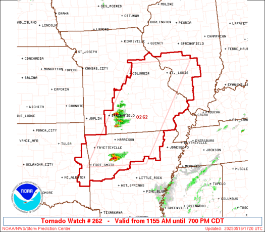
99% chance of a tornado watch issued for Evansville late this afternoon.
They have wind gusts to 70 mph, hail to 4" and strong tornadoes as threats.
https://www.spc.noaa.gov/products/watch/ww0262.html
Temperature in red(warm)/brown(cold). Dew points in dashed blue.
Isobars/pressure in black.
Updated every 6 minutes.
Lower Midwest sector below:
https://www.spc.noaa.gov/exper/mesoanalysis/new/viewsector.php?sector=20#
12 noon image below.
Constant updates here:
https://www.marketforum.com/forum/topic/83844/#83845

As expected, storms have quickly erupted in MO from nothing a short while ago.
This is St. Louis below. Watching these storms will tell us what to expect this evening, downstream.

++++++++++++++++
Storm reports just getting started.
The automatically updated information at these links/sites means that viewing them in the future replaces the key information from this particular time frame.
https://www.spc.noaa.gov/climo/reports/today.html
| Note: All Reports Are Considered Preliminary | |||||||
| |||||||
 | |||||||
Considering the movement, I think we'll have a tornado watch box for our area in the next couple of hours. Storms might get here around 7pm???? First guess.
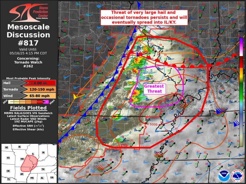
The Storm Prediction Centers latest mesoscale discussion/update below, valid thru 4:15 pm. Serious stuff inside the purple box which is expected to continue eastward and likely be impacting Evansville area during the early/middle evening hours.
https://www.spc.noaa.gov/products/md/md0817.html
Always entertaining and informative: Ryan Hall Y'all.
https://www.youtube.com/watch?v=mTkFSVhoF4g
Crossing into IL. That storm is now in western IL.
+++++++++++++
The Storm Prediction Center just updated their verbiage on the moderate risk zone:
It just confirms the elevated risk for us. Serious, potentially life threatening, long track strong tornadoes this evening.
New tornado watch too just issued that includes Evansville. More in a minute!
https://www.spc.noaa.gov/products/watch/ww0265.html
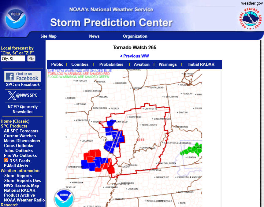
Local NWS for Evansville IN area. Tornado watch until 10pm but the storms will hit Evansville BEFORE ~7pm-ish.
National Weather Service Paducah, KY area of responsibility:
DO be prepared to go to a safe place if a tornado warning is issued for your county the rest of today.
Some activity developing ahead of the scattered severe storms here at 5pm. So the potential storms may get here before 6pm.
Update: Those are passing south of Evansville(also severe storms much farther north):
Tornadoes to 170 mph possible in the blue shaded area of western KY.
Still a risk for tornadoes this evening for the entire red shaded area but the storms should be widely scattered and severe weather may just be isolated unless they suddenly develop the next 2 hours.
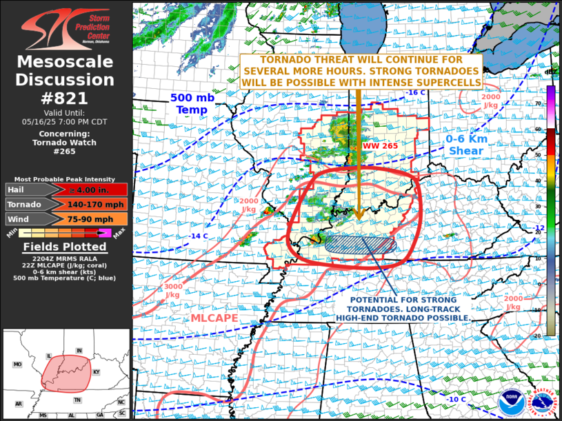
https://www.spc.noaa.gov/products/md/md0821.html
And THEY DID suddenly develop in the last hour.
Elevated risk around 7pm in Evansville:
6:25pm: Tornado emergency for large, strong tornado on the ground in the storm that is currently aimed at around Union/Henderson County KY after 7pm.
This is part of a developing LINE of storms, any of which could be severe when they come thru Evansville around 7pm.
The most severe part of the line looks like it will hit just south of the Ohio River but the storms are developing fast.
6:44pm;
Tornado emergency extended east. Several homes leveled in the past 30 minutes from a large, long lived strong tornado. Passing thru Harrisburg, IL. Currently aimed at just south of the Ohio River.
6:53pm: The severe storms aimed at Evansville have no history of tornado activity so far
6:57pm: Tornado emergency warning extended to Union County Ky until 7:30. Large Tornado is moving east and not aimed at Evansville. This large tornado is the same one thats been on the ground for around 40 minutes. This is called a long track tornado. Probably at least 150 mph.
7:02pm. Warning for Vanderburgh county. Severe Thunderstorm warning until 7:47 pm. This is better than a tornado warning but a tornado is still possible.
7:09 pm. Large tornado crossing the Ohio River at Shawneetown into western KY.
7:13pm. New tornado emergency warning thru most of Henderson county SOUTH of the city of Henderson.
7:20 pm: Did they cancel the severe thunderstorm warning in V county? It's gone now. Maybe it was a mistake to begin with. The sirens went off here. Severe part of these storms staying south of the Ohio River.
7:35 pm Tornado still on the ground in western Ky, southwestern Henderson County.
7:41pm: Sirens going off again in V county for a tiny sliver along the bend of the Ohio River that sticks out south(around 3% of the county). No threat to the rest of V county from this warning.
7:53 pm: Continued tornado emergency warning extended to Daviess Co to just south of Owensboro.
7:56 New Severe Thunderstorm Warning (sirens going off) for V county from a wave along the northern edge of the storms. Highest threat (minor)in SOUTHERN V county which is under the warning, NOT the northern half of V county.
8:08 pm. The back edge is now passing thru the western parts of southern V country and will be out of V county for good in 10 minutes.
8:16pm: This was crazy. I watch Wayne Hart on WEHT to see his radar and interpretation. Their radar images and warnings were different than the NWS at times and different than the warnings and sirens on cable tv at times when it came to Vanderburgh County.
8:22 pm: Still a warning for the storm that caused the long track strong tornado but no longer an elevated, tornado emergency.
Severe storms and tornadoes to our north, west and south but Evansville and Southwest IN dodged the severe storm bullet this time.
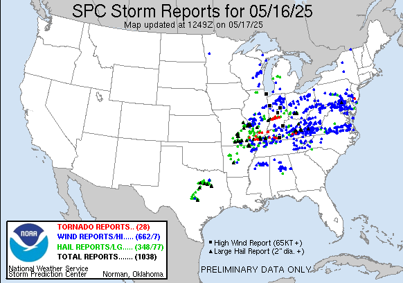
https://www.spc.noaa.gov/climo/reports/today.html
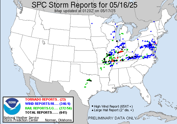
Updated severe weather reports from Friday 6am to Saturday 6am.
1. Over 1,000 severe weather reports in a 24 hour period. That ranks way up there and part of it was the extent of the area impacted.
2. Massive number of severe thunderstorm winds but most of those were much farther east, associated with a completely different part of this weather system that did not have the most elevated risk(just a slight risk).
3. Reports on the western (more dangerous to life) side of the storm featured hail, including giant sized hail. Also tornadoes, including at least several EF2, long track tornadoes. 1 that went from southern IL into western KY just south of Evansville.
4. Far southwestern IN went untouched, with widespread severe weather reported all around us.
https://www.spc.noaa.gov/climo/reports/250516_rpts.html
++++++++
These deaths were in eastern KY.
https://www.wlky.com/article/kentucky-tornado-deaths-laurel-county-survivors-search/64799829
++++++++=
Over 400,000 customers are without power from Michigan to Tennessee.
https://abcnews.go.com/US/dozen-people-dead-states-storms-hold-americas-heartland/story?id=121901123
A comment on the warnings and information delivery systems.
1. Nobody can do a better job than the Storm Prediction Center or NWS when it comes to issuing valuable information that includes assessments, watches, warnings and updates. We owe them a great deal for saving thousands of lives in recent years. The media also deserves great credit. I always have Wayne Hart from WEHT on to see his radar and interpretations.
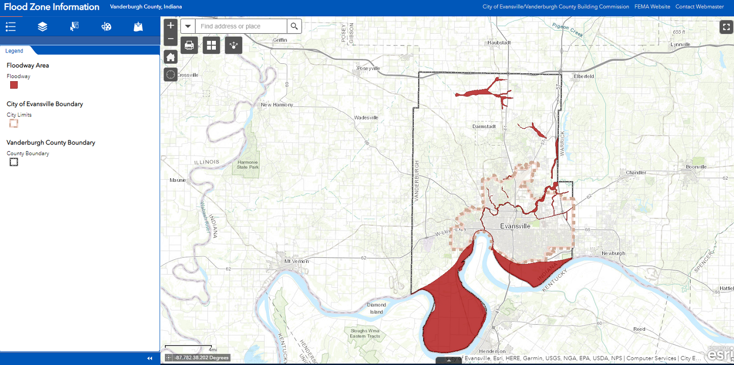
2. However, there are a few flaws in the overall system, a couple of them were on display on Friday. When a warning is issued, even if the warning box includes only a very tiny sliver of a county, the entire county has the sirens go off. Not a problem most of the time, especially with smaller counties and regular shaped counties............which is NOT Vanderburgh County.
Look at the map below and how the Ohio River has a bunch of loops in southern Vanderburgh county. This map that I copied is for flood zones but depicts the issue well. This results in southern Vanderburgh County jutting out south into Kentucky. And northern Henderson, KY County jutting out north into Indiana.
Warning boxes are just that, BOXES which are straight lines, NOT curved lines like the extremely curved lines below along the Ohio River that separates IN counties from KY counties. Yesterday was an example of how warnings for mostly KY can include the loop in the river which includes Vanderburgh County IN. So when a warning is issued that includes only the red shaded area below, the sirens go off EVERYWHERE in the county, all the way to the northern border with Gibson County which is nowhere close to the actual threat.
People in the entire county, including far Northern Vanderburgh County, NOT in the warned area will get the same warning siren that people along the Ohio River get. I have seen this happen half a dozen times, just this year now. Considering how the system is set up, its probably not viable to pinpoint warning locations to be more precise than county borders.
This is mainly bad for people that don't have access to other information at the time..........let's say they are a driver on the road. All they know is that the sirens are going off where they are. telling them there is some sort of emergency.
3. I totally get severe weather cut ins by TV stations. That was my job at WEHT as chief meteorologist from September 1982 to September 1993. Warnings for a couple of rural counties are the hardest to justify against the vast majority of viewers that are having their favorite program interrupted because of information that doesn't impact them.
Potentially saving lives takes precedent over ratings. One thing that makes it much worse today is that people record many of their favorite programs to watch later. So when they are watching this, several days later the threat of severe weather is long gone, even if it was for their county. My personal experience in the business makes me extremely biased but I think most people understand this even if its frustrating.
4. I'm biased in the opposite direction on this one. When there's a warning for any county in the area, our cable company, Spectrum will seize control of our cable box and broadcast a full screen message that lasts 2 minutes with verbiage and audio about the warning that comes from the NWS. One part of me lines up with this mentality, especially since its only 2 minutes long. The other part has a problem because it has COUNTER productive impacts for people that are already following the threat to THEIR county by watching the local meteorologist, with their radar and MUCH better information........which is often me. This is why I'm biased but everybody else watching Wayne Hart on WEHT (for instance) who is showing them the actual storm and telling them much more important information IN ADDITION to the information on the cable message ........are suddenly cut off for 2 minutes to get a message they already knew about. So there are thousands of people that are CUT OFF from their much superior severe weather information source for 2 minutes to repeat an inferior sources message which they already knew about.
With TV station cut ins by meteorologists in #3 it always ADDS to life saving information. Cable company cut ins like this add information for many people, but unfortunately while TAKING AWAY 2 minutes of better information for a minority of others.
Again, I'm extremely biased because during severe weather events, I'm tuned into half a dozen of the best sources at the same time. When Spectrum cable does this, it is always to repeat information that others closely following the weather already, already knew........in a manner that cuts us off from our personal choice to get MORE superior severe weather information.
The technology does not allow for them to run crawls or do a half screen cut ins, while still broadcasting regular programming. All the stations in their cable network have full control of everything on the screen when you watch that program. It comes from an independent data stream that is the only one capable of altering messages or the form for each individual station.
Cable should be able to devise some sort of split screen technology to show both at the same time. Since its only 2 minutes, its not a huge deal most of the time. However, when you have an outbreak with up to 15 different messages over the course of several hours it adds up to a lot of time.
I have plenty of individual/independent sources already so its not hurting me but other people, that are tuned only into their one "go to" superior source are negatively impacted. I accept this as something that has greater good overall than those negative impacts but suggest a more effective way using a split screen technology. It would actually be MUCH appreciated by Spectrum viewers and help their sales/reputation.
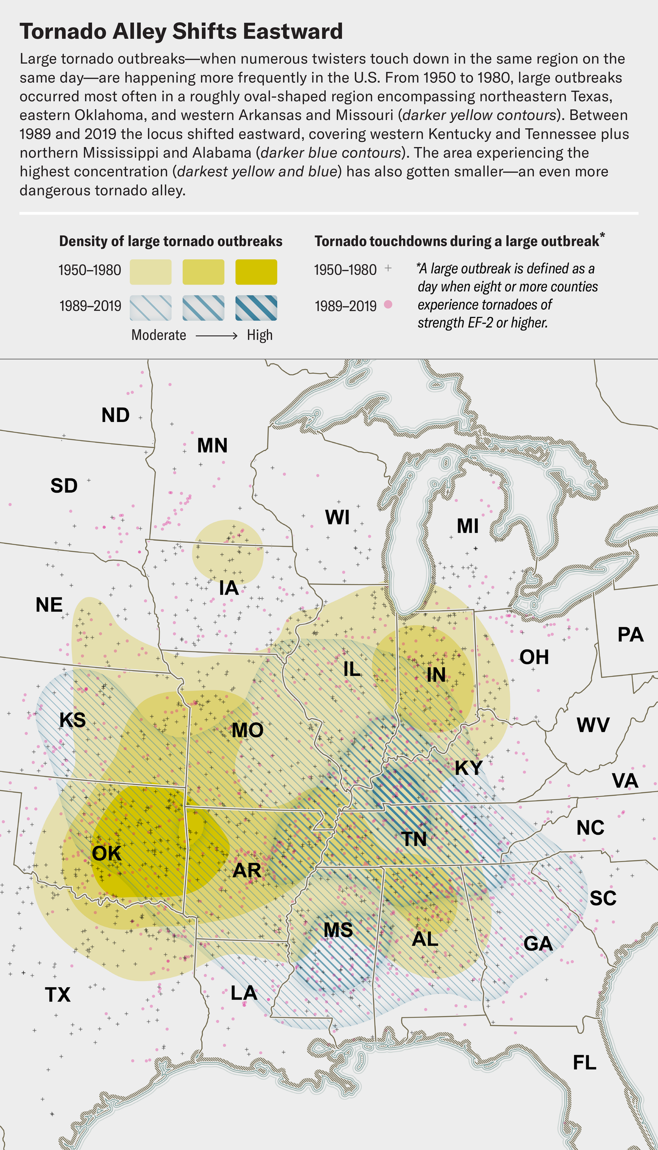
The New Tornado Alley Has Been Hyperactive this Year
More tornadoes than usual have already struck the U.S. in 2025—and many of them have been touching down farther east than they had in the past
https://www.scientificamerican.com/article/the-new-tornado-alley-has-been-hyperactive-this-year/
+++++++++++++++
Scientific American has a big problem with publishing BAD science on the fake climate crisis.
Let's bust them again here. It wants us to believe that global warming has shifted tornado alley farther east and south of where it was before global warming.
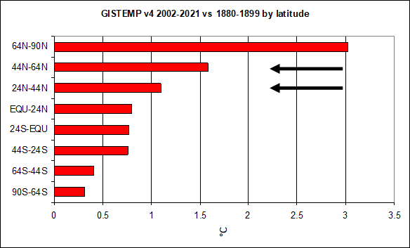
This defies the physical laws of meteorology that tell us that global warming should be shifting violent tornadoes NORTHWARD if it was tied mostly to uniformly warming temperatures from global warming.
The reality is that violent tornadoes have decreased in most places because global warming is warming the coldest places the most and REDUCING the meridianol temperature gradient.
There isn't even a debate to have over this, It's scientifically indisputable!
Re: Severe Weather risk 5-14-25+
By metmike - May 15, 2025, 7:29 p.m.
+++++++++++++++++
If Scientific American was honest, they would be having articles about why violent tornadoes have DECREASED instead of sensationalizing on tornado outbreaks, like the rest of the media during major outbreak years, like 2025 that are part of the expected weather/climate ALL THE TIME.
Ironically, outbreak years are often caused by unusually COLD air penetrating farther south than usual as seasonal warmth from the increasing sun battles to push northward.
Cold Winters often result in increased violent tornadoes that Spring. Mild Winters, like last year often result in a reduction of severe weather the following Spring. This is often related to the elevated strength of jet streams when you have the increased temperature contrasts which are modulated by the cold in the Spring.
Want to reduce violent tornadoes even more? Have more global warming exactly like the past 30 years of global warming!!!
+++++++++++++
This study above is for EF2 tornadoes or stronger, which are the kind that didn't increase because of technology (that increased mostly EF0 and EF1 tornadoes that went under-reported prior do NEXRAD Doppler radars). So that's good.
But look at the honest over all data for the STRONGEST tornadoes:
https://www.marketforum.com/forum/topic/110407/#110432
Re: Re: Severe weather #2 May 7-8, 2024
By metmike - May 10, 2024, 12:11 a.m.
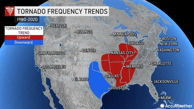
Regardless of all this, it's indisputable meteorology that Indiana and Evansville are in the new tornado alley!
Louisville, KY
Weather Forecast Office
Is tornado frequency increasing in parts of the U.S.?
https://www.weather.gov/lmk/niu_tornado_frequency_study
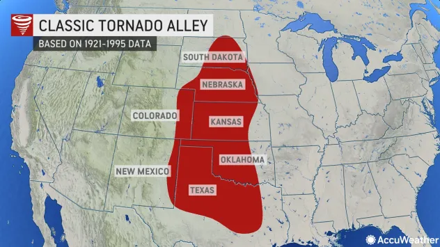
Where is 'tornado alley?' It may be time to update the original definition of the area that gets frequent tornadoes, which was created before the turn of the century.
ByAllison Finch, AccuWeather staff writer
Published Apr 25, 2022 1:46 PM
https://www.accuweather.com/en/severe-weather/is-tornado-alley-shifting-east/1162839
3-30-25 TORNADO outbreak on 4-2-25
By metmike - May 17, 2025, 7:28 p.m.
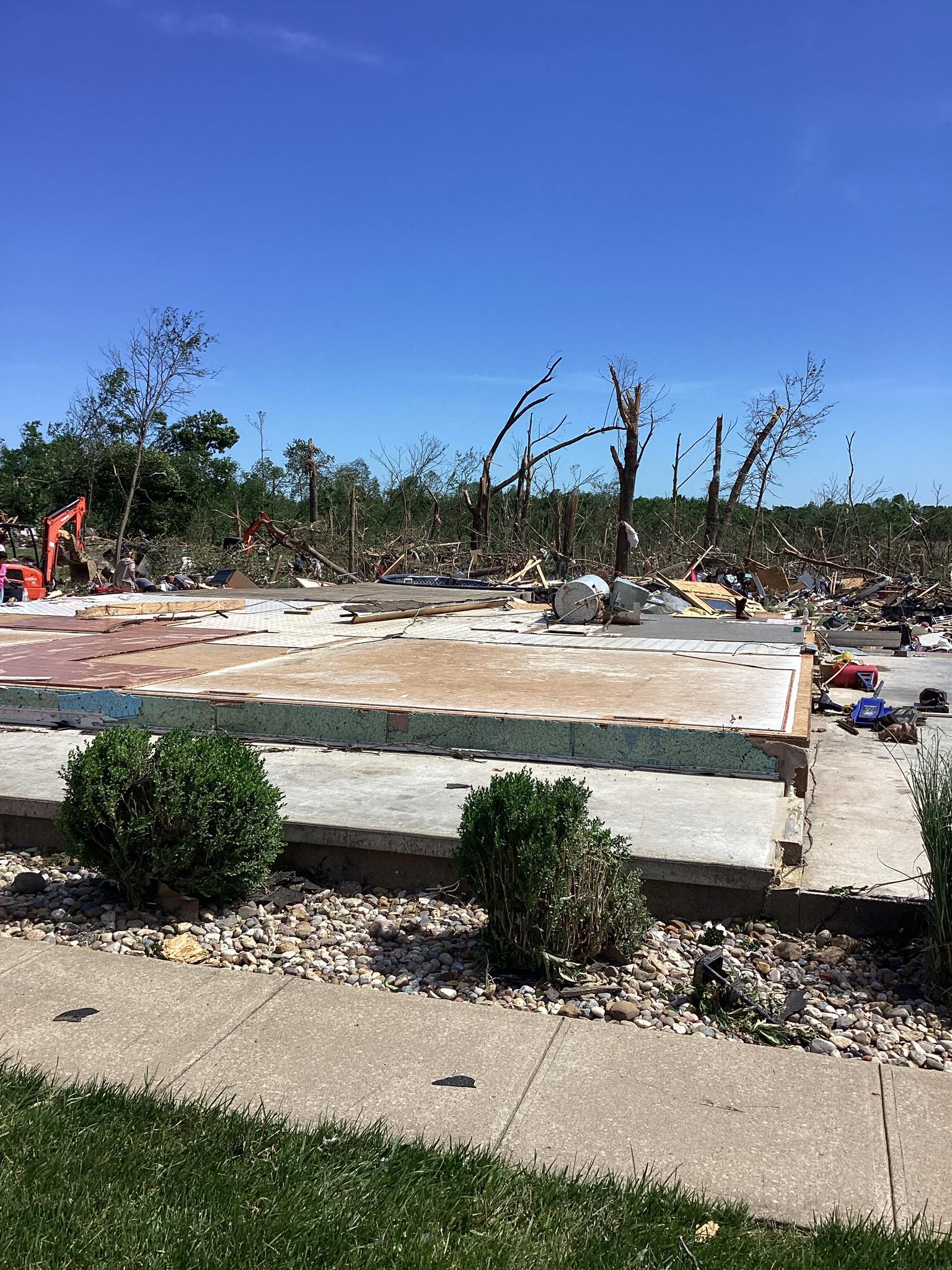
The NWS is just starting their survey of the damage from yesterday's storms.
May 17, 2025 • United States
+++++++++++=
I love the name of this organization! The parable of the good Samaritan has always been my favorite parable of Jesus!
https://www.biblegateway.com/passage/?search=Luke%2010%3A25-37&version=NIV
++++++++++++++==
![]()
https://cfbmc.org/tornado-recovery/
+++++++++++
https://www.fox19.com/2025/05/17/matthew-25-ministries-responds-devastating-kentucky-tornadoes/
https://watchers.news/2025/05/17/tornado-emergency-violent-tornado-marion-illinois/
Tornado Emergency is an enhanced form of tornado warning issued by the NWS, reserved for confirmed, ongoing tornadoes posing an imminent threat to life and property, typically when a large, destructive tornado is moving into a populated or particularly vulnerable area.
++++++++++
The Storm Prediction Center and local NWS did a hall of fame type job in issuing accurate and timely outlook statements, watches, warnings, updates and even the rare tornado emergencies yesterday....... well ahead of the tornadoes hitting!
This along with the media and other sources is how you save lives!!!
https://www.marketforum.com/forum/topic/111845/#111864
https://www.marketforum.com/forum/topic/111845/#111865
https://www.marketforum.com/forum/topic/111845/#111890
https://www.marketforum.com/forum/topic/111845/#111895
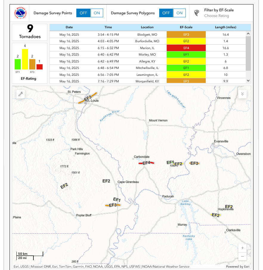
https://en.wikipedia.org/wiki/Tornado_outbreak_sequence_of_May_15%E2%80%9316,_2025
HENDERSON, Ky. (WEHT)- Residents of Morganfield are continuing to clean up after an EF3 tornado hit on Friday night.
National Weather Service releases details of Morganfield tornado
The tornado’s winds peaked at 155 miles per hour and had a maximum width of five football fields, lasting for just under 10 miles.
++++++++++++++++++++
esrondptoSaP04 h:h71ur6ttYefs04 155970a55411 6dyM018ft52het6 ·
The tornado that struck Marion, IL on May 16 has been rated as an EF4, with winds reaching up to 190 mph. This marks the strongest tornado in Illinois since the Rochelle tornado a decade ago.
metmike: This was actually from the same mesocyclone that tracked east and produced the EF3 tornado in Western KY around an hour later. As a result the residents in western KY had a tornado emergency warning in effect for over 40 minutes before that system reached them and that tornado hit.
Most tornadoes come from mesocyclones aloft. Most mesocyclones do NOT produce tornadoes but their signature can be well recognized.
https://www.weather.gov/pah/2025May16_Severe
https://en.wikipedia.org/wiki/Mesocyclone
A mesocyclone is a meso-gamma mesoscale (or storm scale) region of rotation (vortex), typically around 2 to 6 mi (3.2 to 9.7 km) in diameter, most often noticed on radar within thunderstorms. In the Northern Hemisphere, it is usually located in the right rear flank (back edge with respect to direction of movement) of a supercell, or often on the eastern, or leading, flank of a high-precipitation variety of supercell. The area overlaid by a mesocyclone’s circulation may be several miles (km) wide, but substantially larger than any tornado that may develop within it, and it is within mesocyclones that intense tornadoes form

The gallery below shows the three stages of development of a mesocyclone and a view of the storm relative motion on radar of a mesocyclone-producing tornado over Greensburg, Kansas on 4 May 2007. The storm was in the process of producing an EF5 tornado at the time of the image.


