Severe Storms 7-28-25
3 responses | 0 likes
Started by metmike - July 28, 2025, 6:25 p.m.

Severe Storm Risk......updated  daily(days 1 and 2 twice daily).

https://www.spc.noaa.gov/

https://www.spc.noaa.gov/products/outlook/

Current Day 1 Outlook
        1300 UTC Day 1 Outlook             
         
          Current Day 2 Outlook
          0600 UTC Day 2 Outlook
Comments
By metmike - July 28, 2025, 6:27 p.m.
Like Reply

https://www.wunderground.com/maps/radar/current

Static map


Recent rain amounts:

weathernet.com/total-rainfall-map-24-hours-to-72-hours

+++++++++++++++

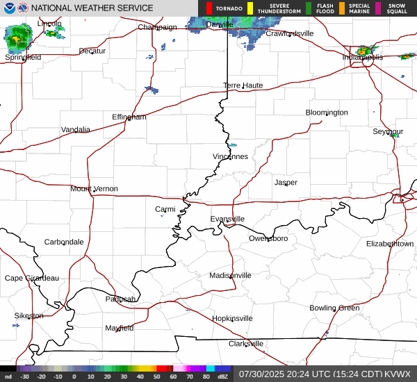
Current Hazards at the link below.

For your NWS and county, go to the link below.

 Then you can hit any spot on the map, including where you live and it will go to that NWS with all the comprehensive local weather information for that/your county. 


https://www.weather.gov/                                                                                                                 


                                    Here's what the colors on the map above stand for:

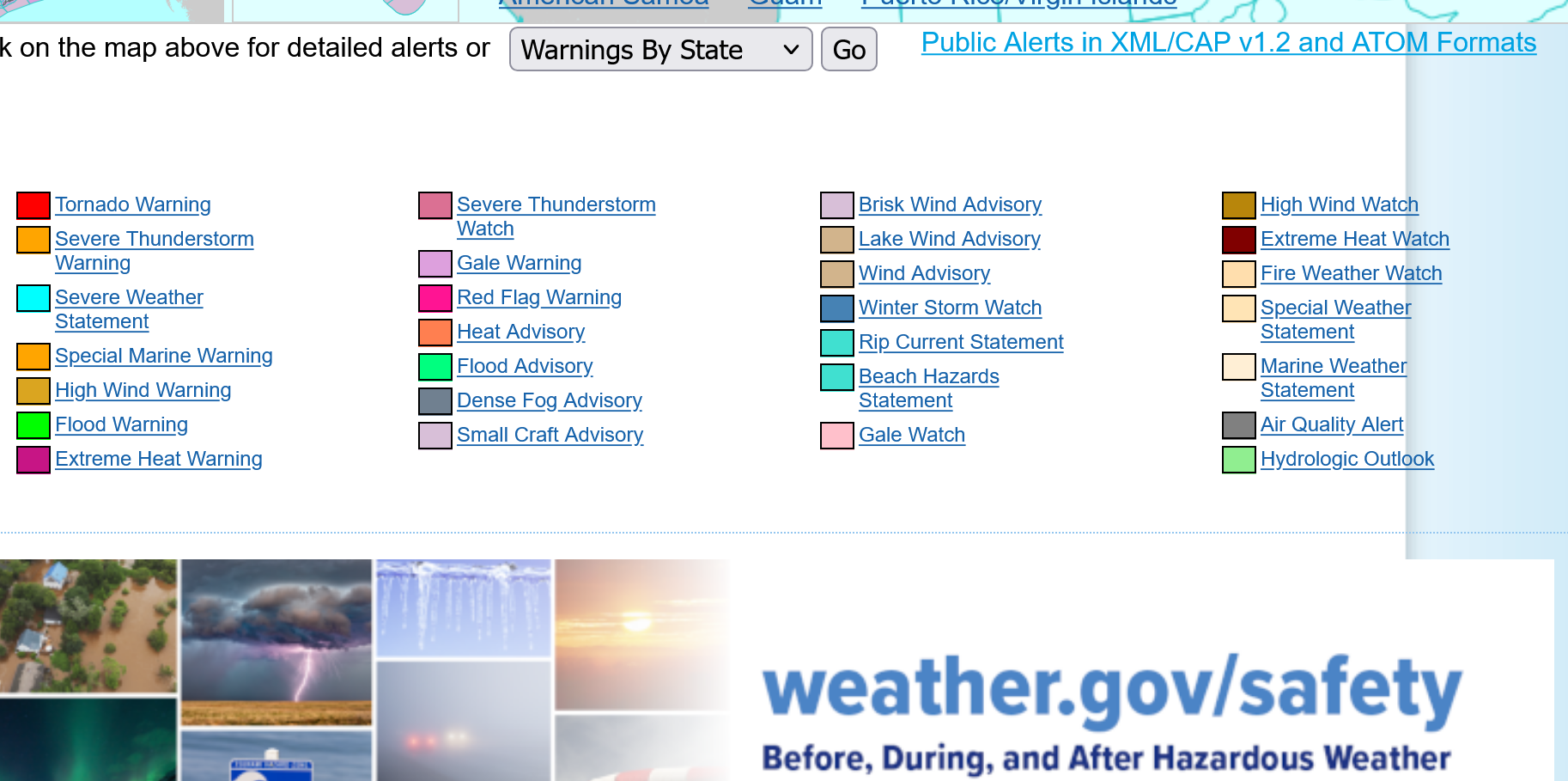
+++++++++++++++++++++++++++++++++

New radar product below          

 https://radar.weather.gov/?settings=v1_eyJhZ2VuZGEiOnsiaWQiOm51bGwsImNlbnRlciI6Wy05NC45OCwzNy4wMl0sImxvY2F0aW9uIjpudWxsLCJ6b29tIjo0fSwiYW5pbWF0aW5nIjpmYWxzZSwiYmFzZSI6InN0YW5kYXJkIiwiYXJ0Y2MiOmZhbHNlLCJjb3VudHkiOmZhbHNlLCJjd2EiOmZhbHNlLCJyZmMiOmZhbHNlLCJzdGF0ZSI6ZmFsc2UsIm1lbnUiOnRydWUsInNob3J0RnVzZWRPbmx5IjpmYWxzZSwib3BhY2l0eSI6eyJhbGVydHMiOjAuOCwibG9jYWwiOjAuNiwibG9jYWxTdGF0aW9ucyI6MC44LCJuYXRpb25hbCI6MC42fX0%3D

Go to: "Select View" then "Local Radar"

Hit the purple circle to see that local radar site

+++++++++++++++++++++++NY - BinghamtonND - BismarckNH - BerlinTX - BrownsvilleKY - Bowling GreenMI - CadillacNC - CharlotteGA - ColumbusOH - DaytonCO - DenverIA - Des MoinesFL - Key WestVA - RoanokeCT - HartfordMO - Jefferson CityOK - LawtonNE - North PlatteAR - Little RockMT - LewistownLA - New OrleansID - McCallFL - Saint PetersburgSD - PierreAZ - PrescottUT - ProvoOR - RedmondWY - RivertonNV - RenoNM - RoswellTX - San AntonioVA - StauntonKS - SalinaIL - SpringfieldMN - Saint CloudWA - TacomaMS - Vicksburg

                          This link below provides some great data. After going to the link, hit "Mesoanalysis" then,  the center of any box for the area that you want, then go to observation on the far left, then surface observations to get constantly updated surface observations or hit another of the dozens of choices.

https://www.spc.noaa.gov/

 SPC Products Overview 


  https://www.eldoradoweather.com/radar/national-doppler-radar-full-resolution.htmlConus Radar Very High Resolution

By metmike - July 28, 2025, 6:28 p.m.
Like Reply

                                 Ryan Hall, Y'all is ON IT as usual!                                                   

      https://www.youtube.com/watch?v=8LjRo5t6RSE

By metmike - July 28, 2025, 8:41 p.m.
Like Reply

We just missed a huge rain, in Evansville, IN  1 county to the east  


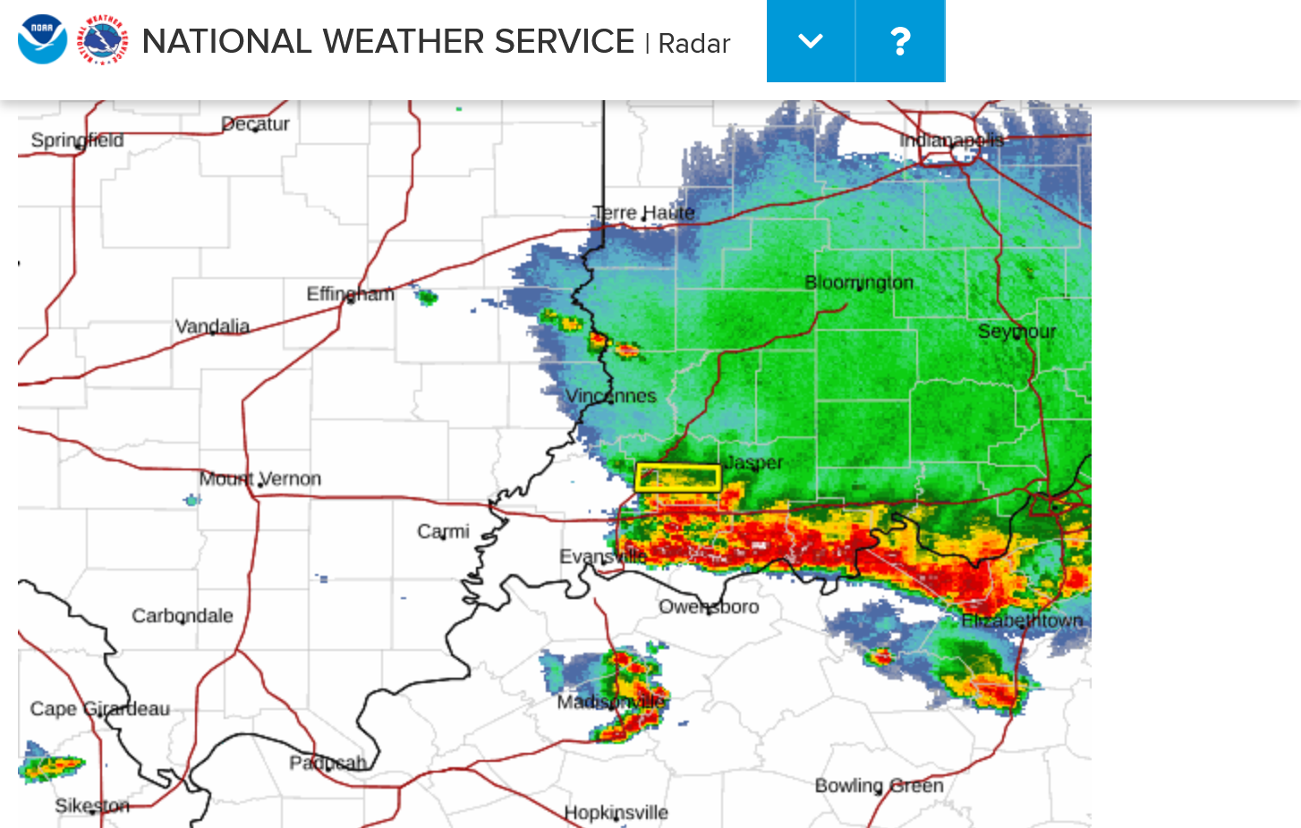
        Local radar Super Resolution Base Reflectivity