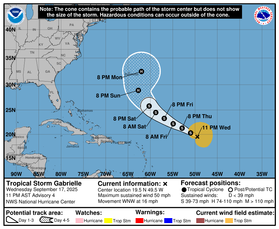
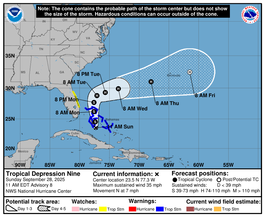
No threat to the United States!
Minimal hurricane in 4 days.
https://www.nhc.noaa.gov/graphics_at2.shtml?start#contents
Previous threads:
Tropical Storm Ferdinand/Tropics
31 responses |
Started by metmike - Aug. 25, 2025, 5:17 p.m.
https://www.marketforum.com/forum/topic/114178/
2025 NATL Tropical Season
18 responses |
Started by WxFollower - Aug. 3, 2025, 12:08 p.m.
https://www.marketforum.com/forum/topic/113730/
Gabrielle is now off limits to children as she’s now a naked swirl.
Good one, Larry!
A "naked swirl" is a colloquial term used by meteorologists and weather enthusiasts to describe a tropical storm whose low-level wind circulation is clearly visible on satellite imagery, but is stripped of its organized thunderstorm activity due to environmental conditions
. This happens when the storm is fighting against high wind shear and dry air.
A naked swirl is not an official meteorological classification, but rather a descriptive phrase for a disorganized tropical cyclone
+++++++++++
Gabrielle predicted to be almost a cat. 2 in 5 days.
https://www.nhc.noaa.gov/graphics_at2.shtml?start#contents

Discussion here:
https://www.nhc.noaa.gov/text/refresh/MIATCDAT2+shtml/211455.shtml?
Gabrielle expected to undergo RAPID INTENSIFICATION the next 36 hours, going from a 65 mph tropical storm to an almost cat. 3 hurricane at 110 mph in that short period of time!!
A storm/hurricane that increases at least 35 mph in 24 hours qualifies.
In this case, the next 24 hours, going from 65 mph to 100 mph is +35 mph!
++++++++++++++++++++++++++++++
https://en.wikipedia.org/wiki/Rapid_intensification
Rapid intensification (RI) is any process wherein a tropical cyclone strengthens very dramatically in a short period of time. Tropical cyclone forecasting agencies utilize differing thresholds for designating rapid intensification events, though the most widely used definition stipulates an increase in the maximum sustained winds of a tropical cyclone of at least 30 knots (55 km/h; 35 mph) in a 24-hour period. However, periods of rapid intensification often last longer than a day. About 20–30% of all tropical cyclones undergo rapid intensification, including a majority of tropical cyclones with peak wind speeds exceeding 51 m/s (180 km/h; 110 mph)

Infrared satellite loop of Hurricane Jova undergoing rapid intensification in September 2023
Rapid intensification constitutes a major source of error for tropical cyclone forecasting, and its predictability is commonly cited as a key area for improvement. The specific physical mechanisms that underlie rapid intensification and the environmental conditions necessary to support rapid intensification are unclear due to the complex interactions between the environment surrounding tropical cyclones and internal processes within the storms. Rapid intensification events are typically associated with warm sea surface temperatures and the availability of moist and potentially unstable air. The effect of wind shear on tropical cyclones is highly variable and can both enable or prevent rapid intensification. Rapid intensification events are also linked to the appearance of hot towers and bursts of strong convection within the core region of tropical cyclones, but it is not known whether such convective bursts are a cause or a byproduct of rapid intensification.
The frequency of rapid intensification has increased over the last four decades globally, both over open waters and near coastlines. The increased likelihood of rapid intensification has been linked with an increased tendency for tropical cyclone environments to enable intensification as a result of climate change. These changes may arise from warming ocean waters and the influence on climate change on the thermodynamic characteristics of the troposphere.
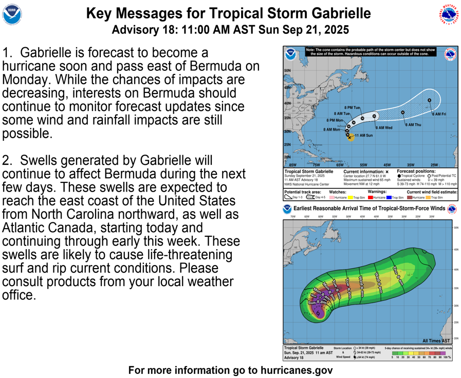
Gabrielle just was designated a hurricane. Still no direct threat to Bermuda.
Thank you, Larry!
Hurricane Gabrielle is likely having rapid intensification. No threat to the US!
is now indicating a 62 to 76 percent chance of a 30 kt increase in intensity over the next 24 h. Thus, I see no reason to not forecast continued steady to rapid intensification over the next 24-36 h, which is in line with the higher end of the intensity guidance, but not as high as the most recent HAFS-A run.
Looks like Gabrielle increased by 55 mph the last 24+ hours(from 65 mph early Sunday) which is clearly rapid intensification as defined yesterday(at least +35 mph/24 hours)
Now at 120 mph, a MAJOR hurricane. Peaking at 130 mph later today. No threat to the United States.
https://www.nhc.noaa.gov/text/refresh/MIATCDAT2+shtml/211455.shtml?
https://www.nhc.noaa.gov/graphics_at2.shtml?start#contents
Gabrielle is at 140 mph, a MAJOR hurricane right now!! That's an increase of 75 mph since Sunday Morning, when it was 65 mph and just a tropical storm.
That's the thing with rapid intensification just like this. It's almost impossible to predict the intensity. We can predict conditions favorable for rapid intensification and predict rapid intensification, like the NHC did, initially going from 65 mph to 110 mph but the fact that it IS RAPID INTENSIFICATION IS WHAT MAKES IT NEARLY IMPOSSIBLE TO PREDICT THE MAGNITUDE WITH PRECISE ACCURACY.
For instance, compare it to +75 mph over 7 days or even 5 days which gives us a gradual change and lots of time to adjust the forecast. However, take that same HUGE increase, spiking up in a brief period, with models that don't agree on the magnitude of the increase, with much less time to make adjustments.
Anything with a much greater rate of change, in fact an anomalous event rate of change will result in a lower predictability skill!!!
Do you agree, Larry?
https://www.nhc.noaa.gov/text/refresh/MIATCDAT2+shtml/211455.shtml?
https://www.nhc.noaa.gov/graphics_at2.shtml?start#contents
https://www.nhc.noaa.gov/refresh/graphics_at2+shtml/230848.shtml?swath#contents
Gabrielle weakening and moving away as expected.
https://www.nhc.noaa.gov/text/refresh/MIATCDAT2+shtml/211455.shtml?
https://www.nhc.noaa.gov/graphics_at2.shtml?start#contents
All eyes are on these 2 disturbances with an 80% and 90% chance of developing!!! The 1 farthest west has a high chance of impacting the East Coast.
https://www.nhc.noaa.gov/gtwo.php?basin=atlc&basin=atlc&fdays=7
 |
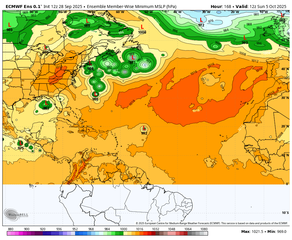
Day 6(early next week) forecast from the last 6z European Ensemble model for Surface Low Pressure of the individual solutions/members. The system above that is farther east is the one most likely to become a hurricane!  |
Hey MM,
I agree 100% about there being low skill for rapid intensification.
————
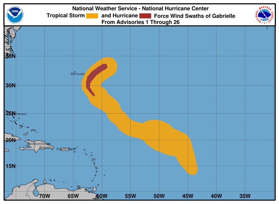
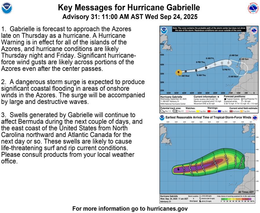
Gabrielle is on the way to the Azores, where there is a (pretty?) rare hurricane warning.
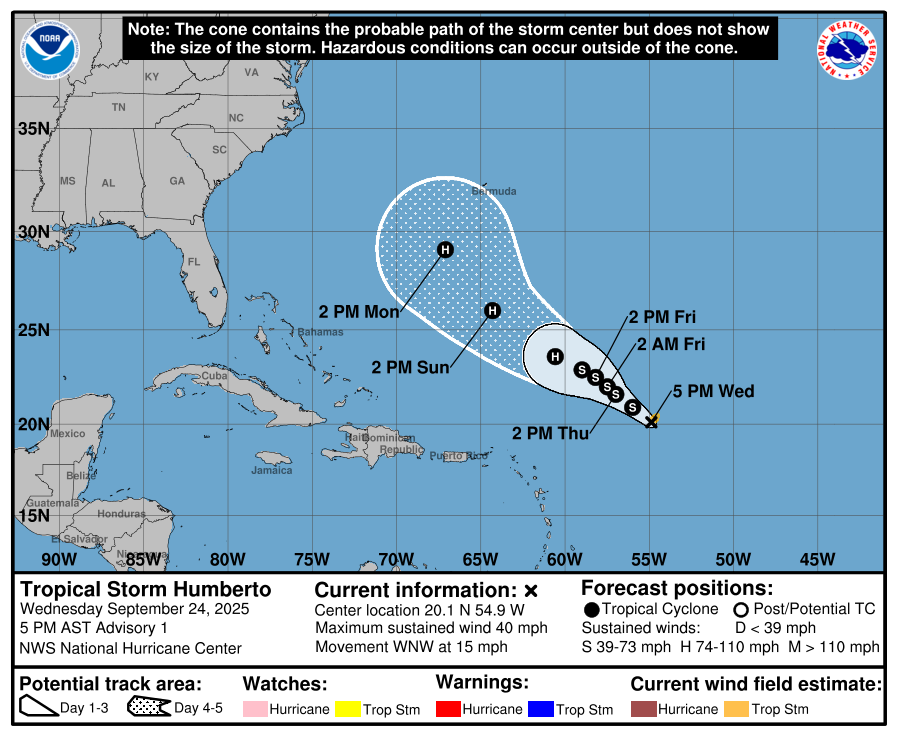
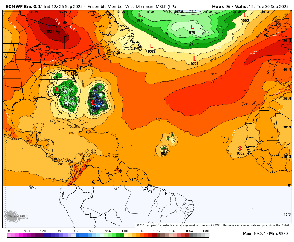
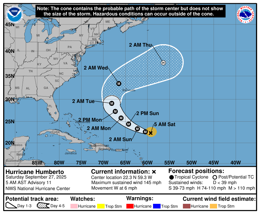
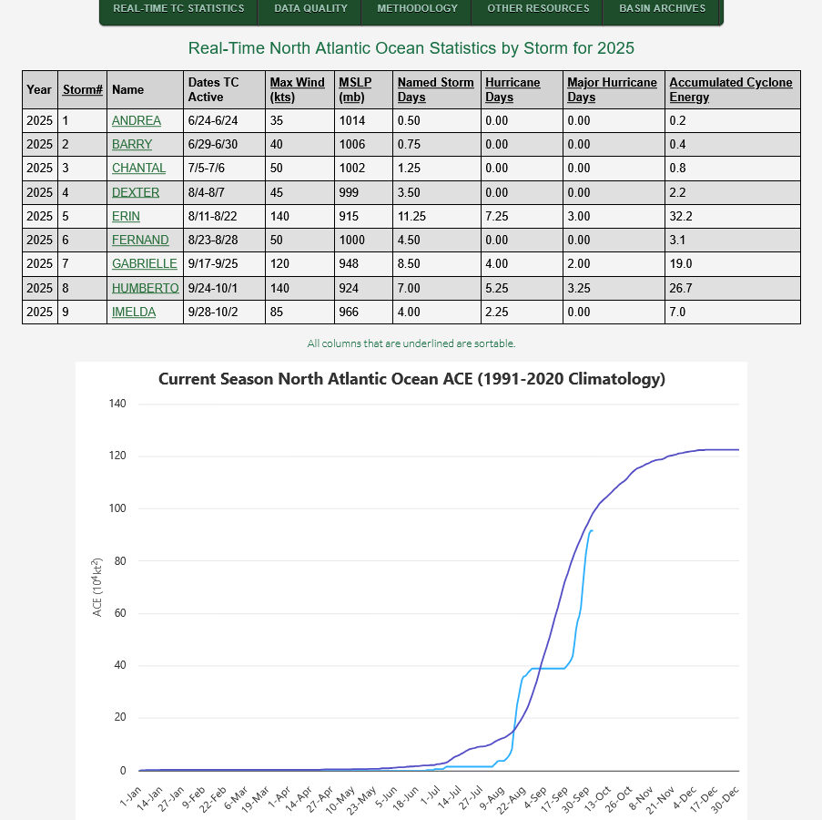
Humberto has been born. It has the potential to become the 3rd major H of the year. Bermuda needs to watch as this may get close.
And soon, Imelda should be born. As you said, that has a chance to hit the US E coast, especially if it doesn’t get pulled closer to Humberto via the Fujiwhara effect.
Thanks much, Larry!
Hello, Humberto! Could be a major hurricane of 110+ early next week!
https://www.nhc.noaa.gov/graphics_at3.shtml?start#contents
https://en.wikipedia.org/wiki/Fujiwhara_effect

When cyclones are in proximity of one another, their centers will circle each other cyclonically (counter-clockwise in the Northern Hemisphere and clockwise in the Southern Hemisphere)[2] about a point between the two systems due to their cyclonic wind circulations. The two vortices will be attracted to each other, and eventually spiral into the center point and merge. It has not been agreed upon whether this is due to the divergent portion of the wind or vorticityadvection.[3] When the two vortices are of unequal size, the larger vortex will tend to dominate the interaction, and the smaller vortex will circle around it. The effect is named after Sakuhei Fujiwhara, the Japanese meteorologist who initially described it in a 1921 paper about the motion of vortices in water.[4][5]

https://www.nhc.noaa.gov/gtwo.php?basin=atlc&basin=atlc&fdays=7
|
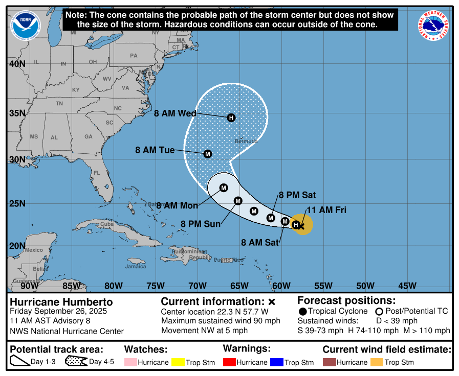
Humberto at 145 mph in 48 hours.
https://www.nhc.noaa.gov/graphics_at3.shtml?start#contents
https://www.nhc.noaa.gov/text/refresh/MIATCDAT3+shtml/261447.shtml?
Day 4 forecast below from the European Ensemble model, Surface Low Pressure for each individual member.
Southeast Coast is a potential target for the very likely I storm, Imelda.
Last day 4 forecast:
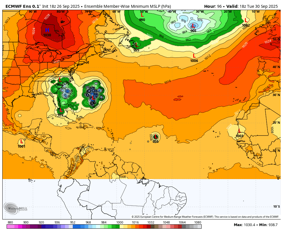
Humberto has gone from 75 mph to the current 145 mph in just 24 hours. That's a 70 mph strengthening in such a short period of time, double what would qualify for rapid strengthening!!!
No threat to the US with a bit of additional strengthening possible the next day or so.
https://www.nhc.noaa.gov/graphics_at3.shtml?start#contents
https://www.nhc.noaa.gov/text/refresh/MIATCDAT3+shtml/261447.shtml?
++++++++++++=
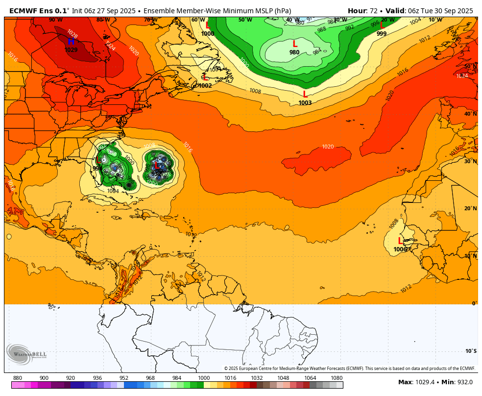
All eyes are on the next system, farther to the west which WILL impact the Southeast US early next week. Likely as a minimal hurricane just off the coast. However, a couple of models have IMELDA barely making landfall.
Lots of uncertainty.
https://www.nhc.noaa.gov/graphics_at4.shtml?start#contents

72 hour forecast from the European Ensemble model with individual members. Surface Low Pressure.
7 Day Total precipitation below:
http://www.wpc.ncep.noaa.govcdx /qpf/p168i.gif?1530796126

Get all the weather here:
Imelda will become a hurricane but NOT a threat to the US.
Models have incredible change to curve Imelda much farther to the right/east!!!!!!
https://www.nhc.noaa.gov/text/refresh/MIATCDAT4+shtml/281451.shtml?
This was the forecast yesterday! Holy Cow, what a change!!!

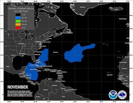
After these 2 hurricanes die in the Atlantic Ocean, the tropics look pretty quiet into October.
7 days from now.
Nothing serious in the main brewing regions.
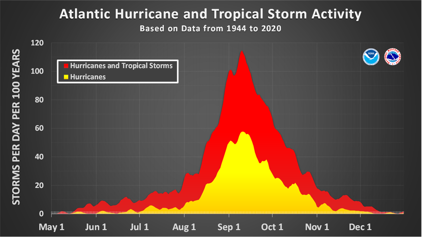
https://www.nhc.noaa.gov/climo/
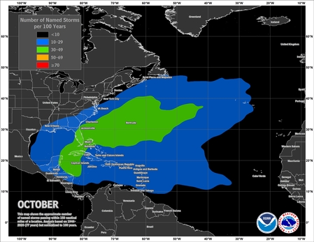
MK said: Chances for a hurricane hitting the US really drop in October but can still happen, especially in FL.
—————
Thanks, Mike!
Whereas the chances for an H to hit the US, overall, drop in Oct, I believe that Oct has had at least as many H hits (if not more than) as that for any other month in Florida thanks mainly to hits on their Gulf side.
Also, I want to say that the European Weeklies have forecasted above average activity for Oct as a whole. We’ll see, but late seasons during La Niña have been more active in average in recent years vs going back further.
Thanks, Larry!
https://en.wikipedia.org/wiki/List_of_Florida_hurricanes
| Month | Number of major hurricanes |
|---|---|
| June | 1 |
| July | 1 |
| August | 6 |
| September | 20 |
| October | 10 |
+++++++++++++++++++++++
https://www.foxweather.com/learn/october-tropics-atlantic-hurricane-season

Thanks, Mike, for correcting me!
Thus, I’m clearly wrong about Oct hurricanes that hit FL. And I’m usually good with H climo. I thought I read that at a tropical wx bb they had a lot of Floridians. I either remember it wrong (most likely) or someone posted misinfo. Maybe someone said Oct of all months has had the largest # of H hits on the W coast of FL due to it having the most formations in the W Caribbean and I remembered it wrong.
You‘re welcome, Larry!
You’ve helped me out too several times when I made boo boos.
Like using the term ancestors incorrectly last month.
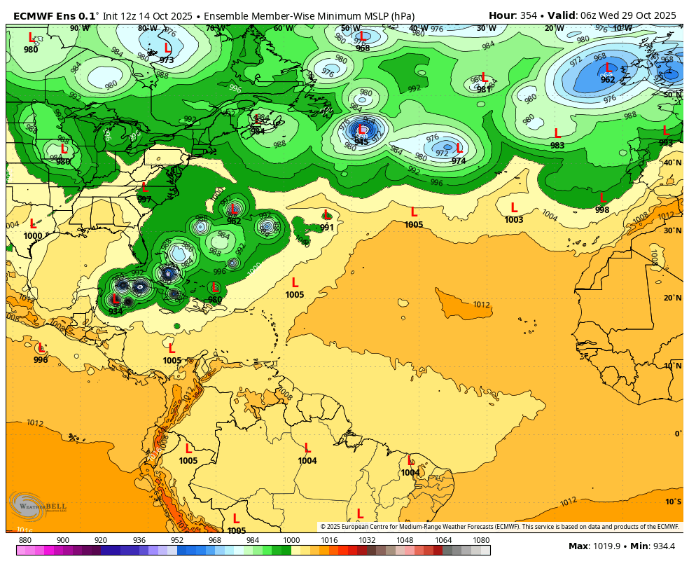
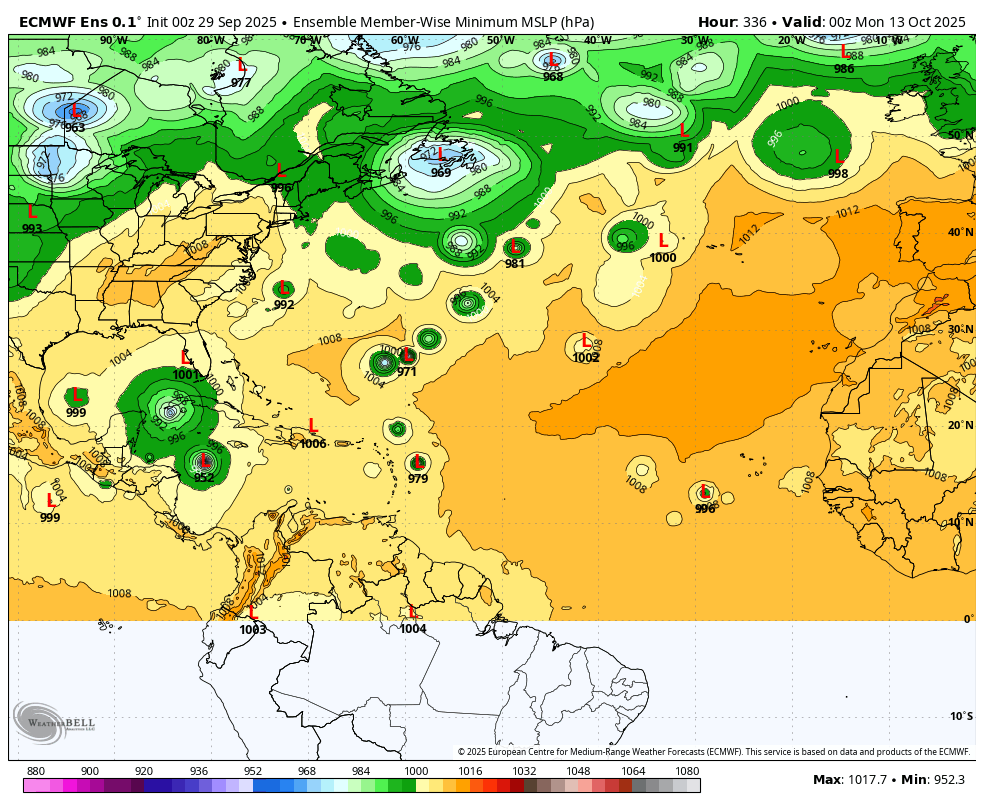
A couple of the European model ensembles want to make the Caribbean and GOM more active in week 2. This is towards the end of 2 weeks when models have very low skill
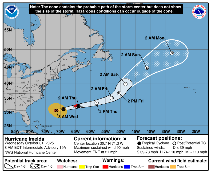
Cat. 1, Hurricane Imelda headed farther out into the Atlantic.
https://www.nhc.noaa.gov/text/refresh/MIATCDAT4+shtml/010855.shtml?
https://www.nhc.noaa.gov/refresh/graphics_at4+shtml/011155.shtml?cone#contents
We can start a discussion now about this potentially being a year with close to the least amount of tropical storms/hurricanes hitting the US in the last century.
2009 was another year with almost no US activity, then we have to go back many decades to find anything like this(without verifying with the actual data yet).
A great deal can still happen in the next month, so we have a ways to go. What do you think, Larry?
https://en.wikipedia.org/wiki/List_of_Atlantic_hurricane_seasons
50% chance of something in the tropical Atlantic the next 7 days.
https://www.nhc.noaa.gov/gtwo.php?basin=atlc&basin=atlc&fdays=7
|
This is low skill at 360 hours but it suggests the potential for something in the Gulf of Mexico in mid October. This is the European Ensemble model Surface Low Pressure for individual members:
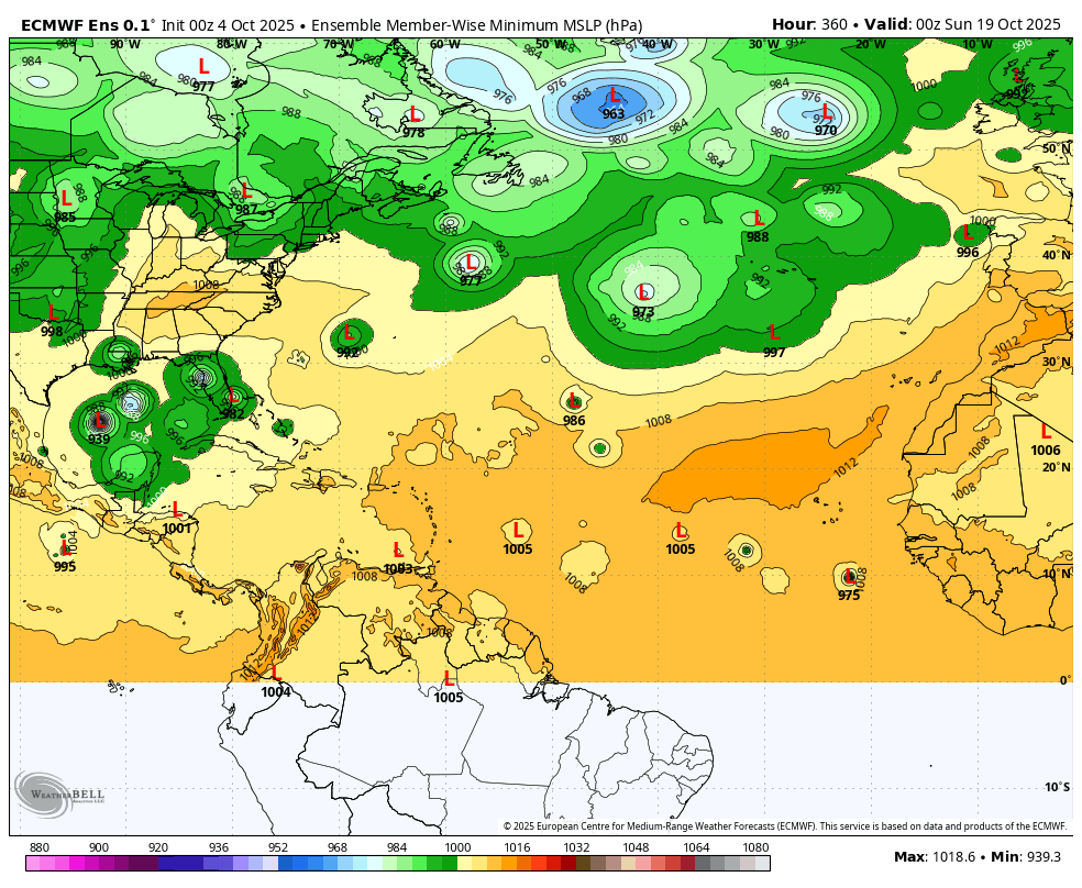
So far, only tropical storm Chantel in early July, has made landfall in the United States. No hurricanes have made landfall. Is this the least US activity the last 100 years if it lasts?
I've not found records for the LEAST number of tropical systems making US landfall, though I can't find a year with 0 that made landfall in the last century.
List of Atlantic hurricane records
https://en.wikipedia.org/wiki/List_of_Atlantic_hurricane_records
+++++++++++++++++++++
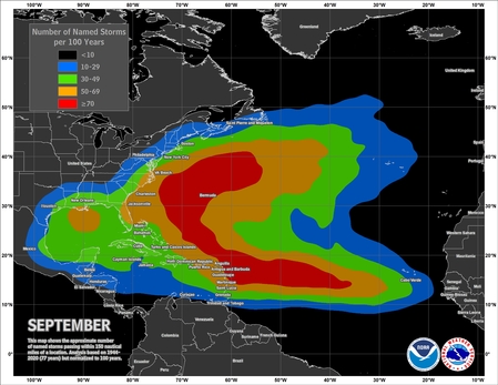
The hurricane tracks this year have been MUCH farther to the east of most hurricane seasons. The Bermuda High that steers them has been much farther east in 2025.
https://en.wikipedia.org/wiki/2025_Atlantic_hurricane_season
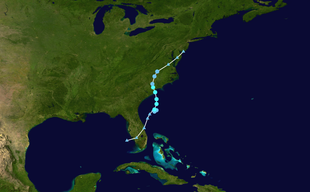
Track map of Tropical Storm Chantal of the 2025 Atlantic hurricane season.
https://tropical.atmos.colostate.edu/Realtime/index.php?loc=northatlantic
I don’t have the least # of tropical systems overall impacting the Conus. But I did post this yesterday at a wx bb:
“Not to minimize TS Chantal, which caused record 24 hour rainfall in some portions of C NC, but will 2025 get through the rest of this season with no Conus hurricane impact for the first season since 2015? The record longest streak with a hurricane impact is 13 seasons (1938-50).
-Since 1851 there have been 34 (20%) seasons with no Conus H impact on record. Of these 34, these were only 6 during La Niña (1872, 1890, 1892, 1973, 2000, and 2010) vs a much higher 15 during El Niño, which is intuitive. The highest ACE of these 34 was 2010’s 165 (La Niña) followed by 1951’s 126 (El Nino).
-Since 1851 there have been only 6 (3%) seasons with a first Conus H impact on record in Oct or later: all were in Oct and none of these 6 had a second one. None were during La Niña. The highest ACE of these 6 was 1853’s 76 followed by 2002’s 68. So, if 2025 were to join them, it would by a good margin have the highest ACE of this group and would be the first during La Niña:
1853 neutral: Oct 20th (GA) when center passing 40 miles off GA from TC 1st reported ~NW Bahamas
1923 El Nino: Oct 16th (LA) from TCG in the EPAC!
1946 neutral: Oct 7th (W FL pen.) from TCG in NW Caribbean
1968 El Niño: Oct 18th (W FL pen.) from TCG in SW Caribbean (Gladys)
1987 El Niño: Oct 12th (Keys/S FL) from TCG in SW Caribbean (Floyd)
2002 El Niño: Oct 3rd (LA) from TCG in C MDR (Lili)”
Thanks a ton, Larry!
Like you stated, what makes this so extraordinary is that we have a La Nina-ish ENSO signal when it's El Nino's that almost always suppress the tropics.
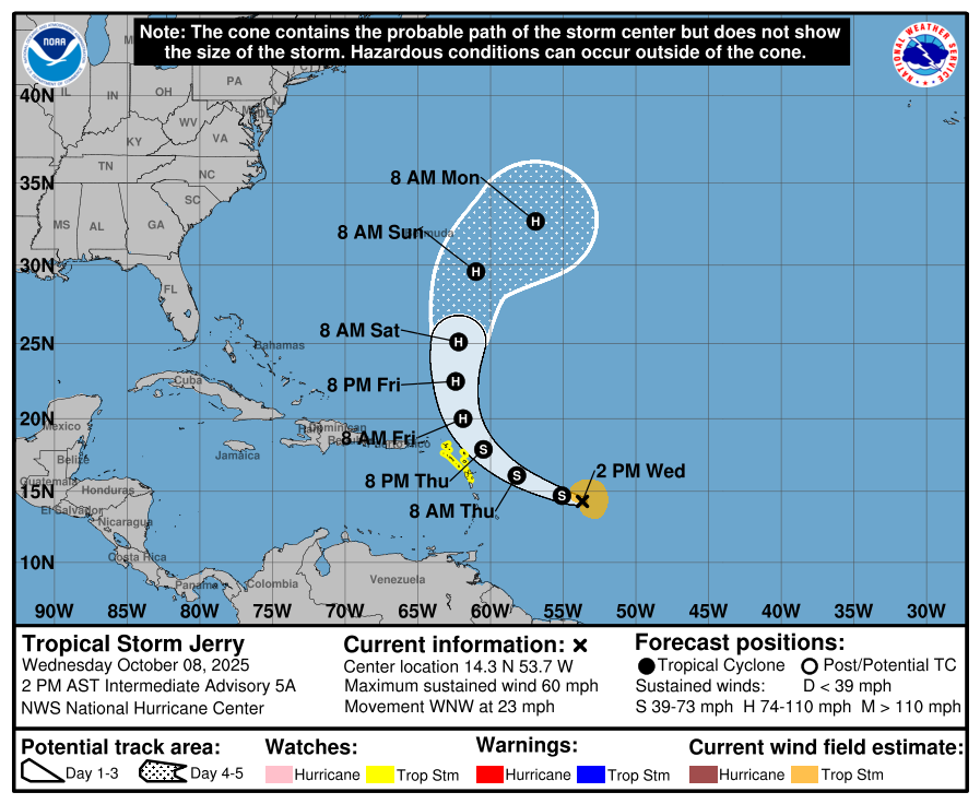
TS Jerry. Reaching minimal hurricane but staying FAR to the east of the United States.
No substantive threats after that either on the latest models.
https://www.nhc.noaa.gov/refresh/graphics_at5+shtml/081741.shtml?cone#contents
Lorenzo is a minimal tropical storm and will be lucky to survive much more than a day before dissipating.
https://www.nhc.noaa.gov/gtwo.php?basin=atlc&basin=atlc&fdays=7
https://www.nhc.noaa.gov/text/refresh/MIATCDAT2+shtml/141435.shtml?
|
In the US, still no hurricanes in 2025 and only 1 tropical storm in early July, Chantel.
Nothing for the next 10 days. However, in 2 weeks the European Ensemble surface low pressure projections for numerous members have a storm to even a major hurricane in a position to threaten the US. This product has low skill for being precise this far out but it's often able to capture/forecast a favorable environment with decent skill, so we should pay close attention!