You can get all the constantly updated, comprehensive weather here:
Weather-UPDATED LINKS
97 responses |
Started by metmike - April 30, 2022, 8:01 p.m.
https://www.marketforum.com/forum/topic/83844/
+++++++=
We'll use this thread to focus on the MUCH colder weather coming up and continuing into December.
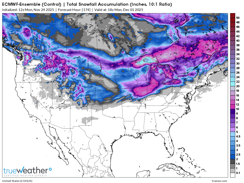
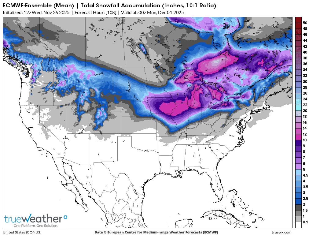
Total snowfall the next 2 weeks from the last 12 European Ensemble model. Most of this is week 2.
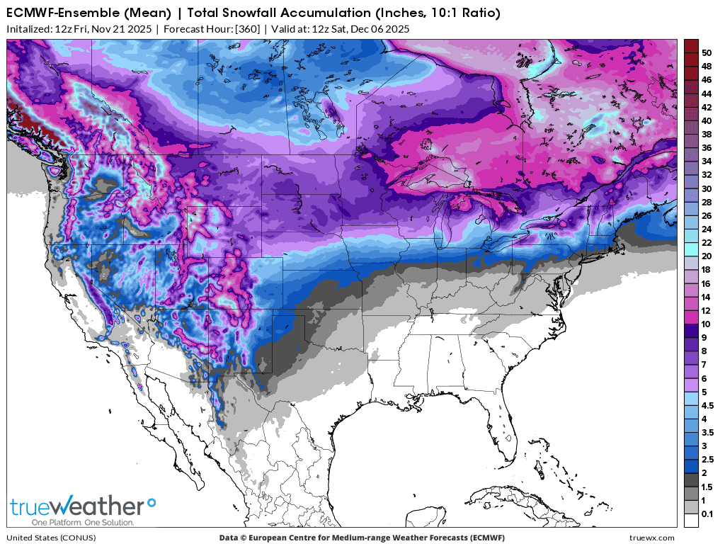
Saturday update:
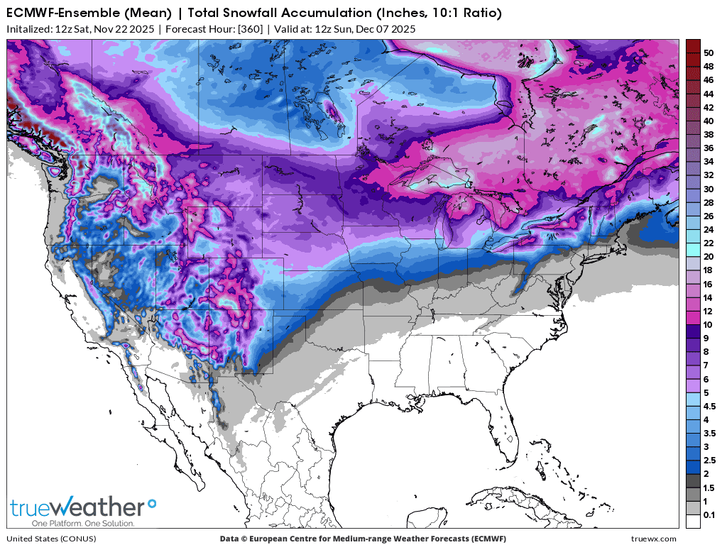
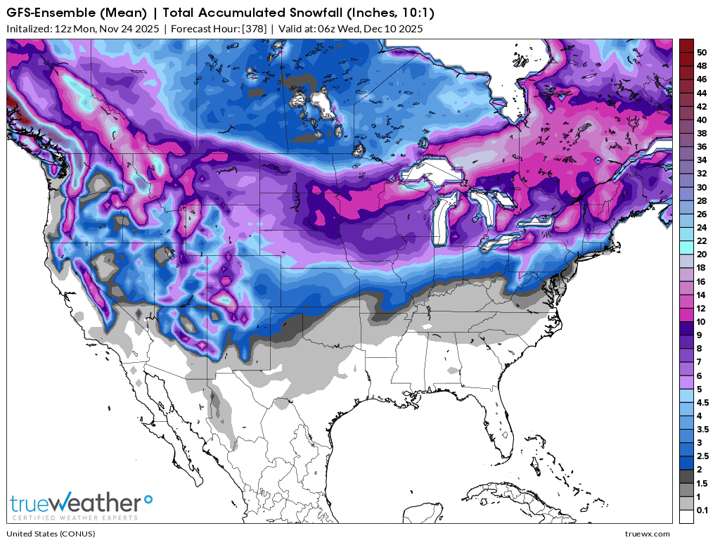
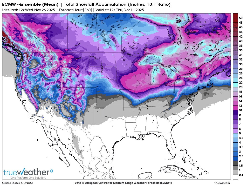
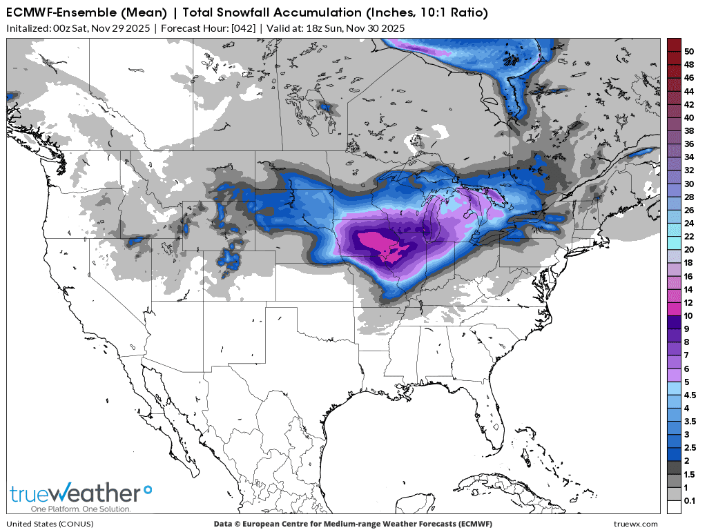
Total snowfall the next 6 weeks(thru January 5, 2026). There will be swaths of snow laid down by individual storms/perturbations, instead of an increasing/decreasing snow gradient distribution pattern like this.
Saturday update:
++++++++++++++++++++++++
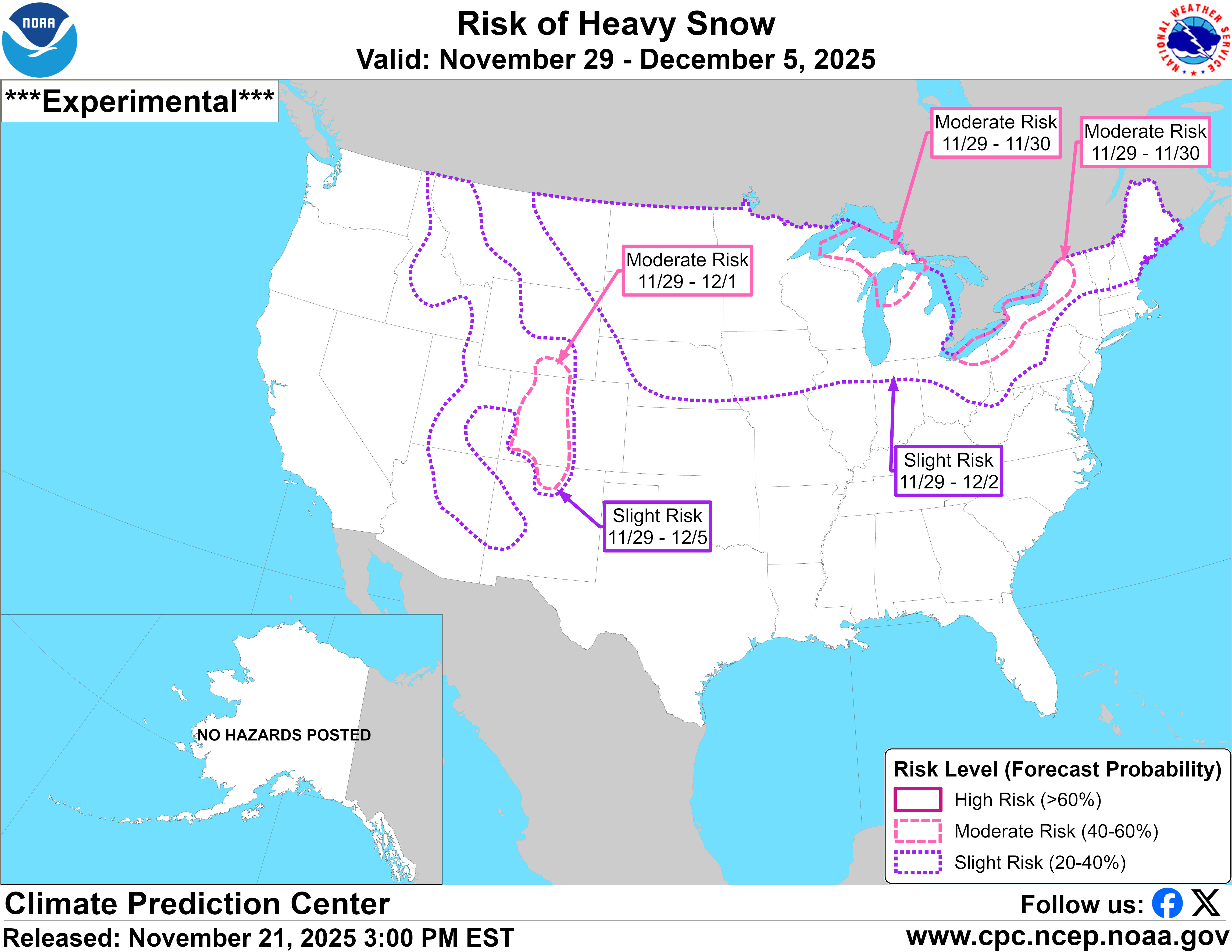
https://www.cpc.ncep.noaa.gov/products/predictions/threats/snow_probhazards_d8_14_contours.png
Saturday update: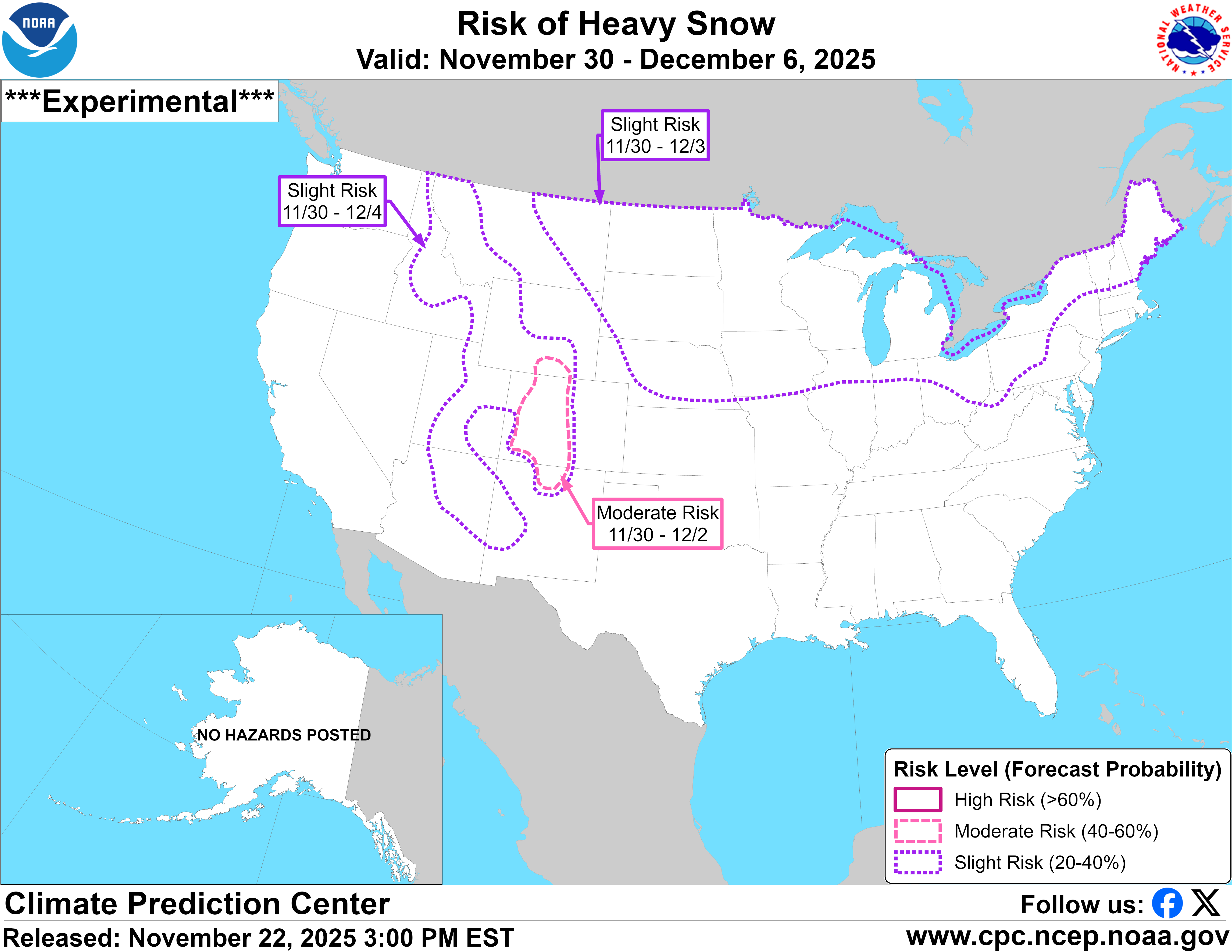
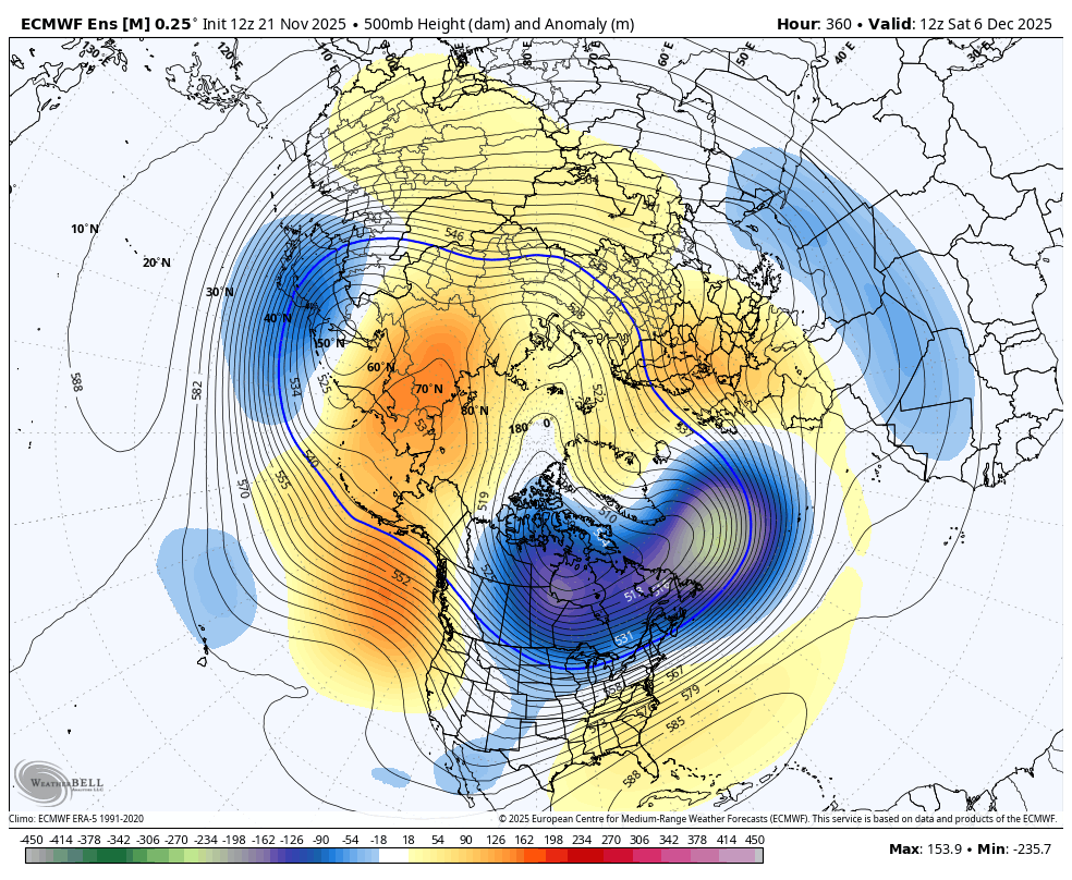
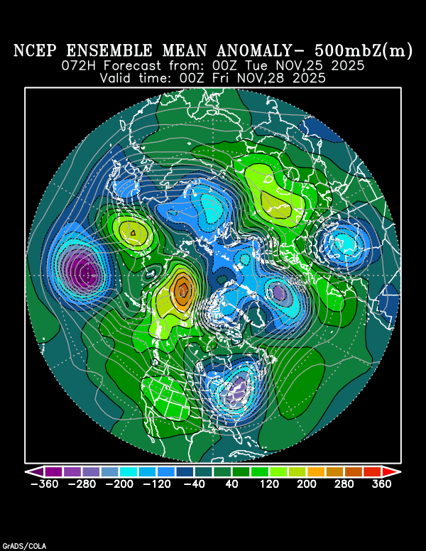
500 mb map from the last 12z European Ensemble model at 360 hours. December 6th. This is around 16,000 feet above the ground and a point where half the atmosphere's weight is above it and half of it is below it.
Anomalies compared to average. Positive anomalies west/negative anomalies east are a favorable couplet(teleconnection) for cold air to be transported from high latitudes to the middle latitudes with the streamlines/jet stream between them spreading Arctic air south, thru Canada into the US, especially the northern US.
We have an upper level ridge off the West Coast but especially from Alaska, almost to Siberia. An extremely deep low over the southwest part of the Hudson Bay is an unusually far south displaced Polar Vortex with some frigid temperatures associated with it.
The cold is coming for much of the US, including here in the SE for Wed-Sat (I’m thankful for this as it looked warm previously/models were dead wrong) but otherwise the SE looks mild for the first half of Dec on the new Euro Weeklies thanks to a strong SE upper ridge. Not what I want to see as I hate sweating in winter when I take my exercise walks! The colder the better for me at all times of year as the SE is normally warm and humid much of the year.
Larry,
You hit the nail right on the head on this upcoming pattern, which is fairly typical for this weak La Nina analog.
The cold northern stream will be dominating the northern half of the country, especially north-central with a southern stream, upper level ridge dominating the south/southeast as you mentioned.
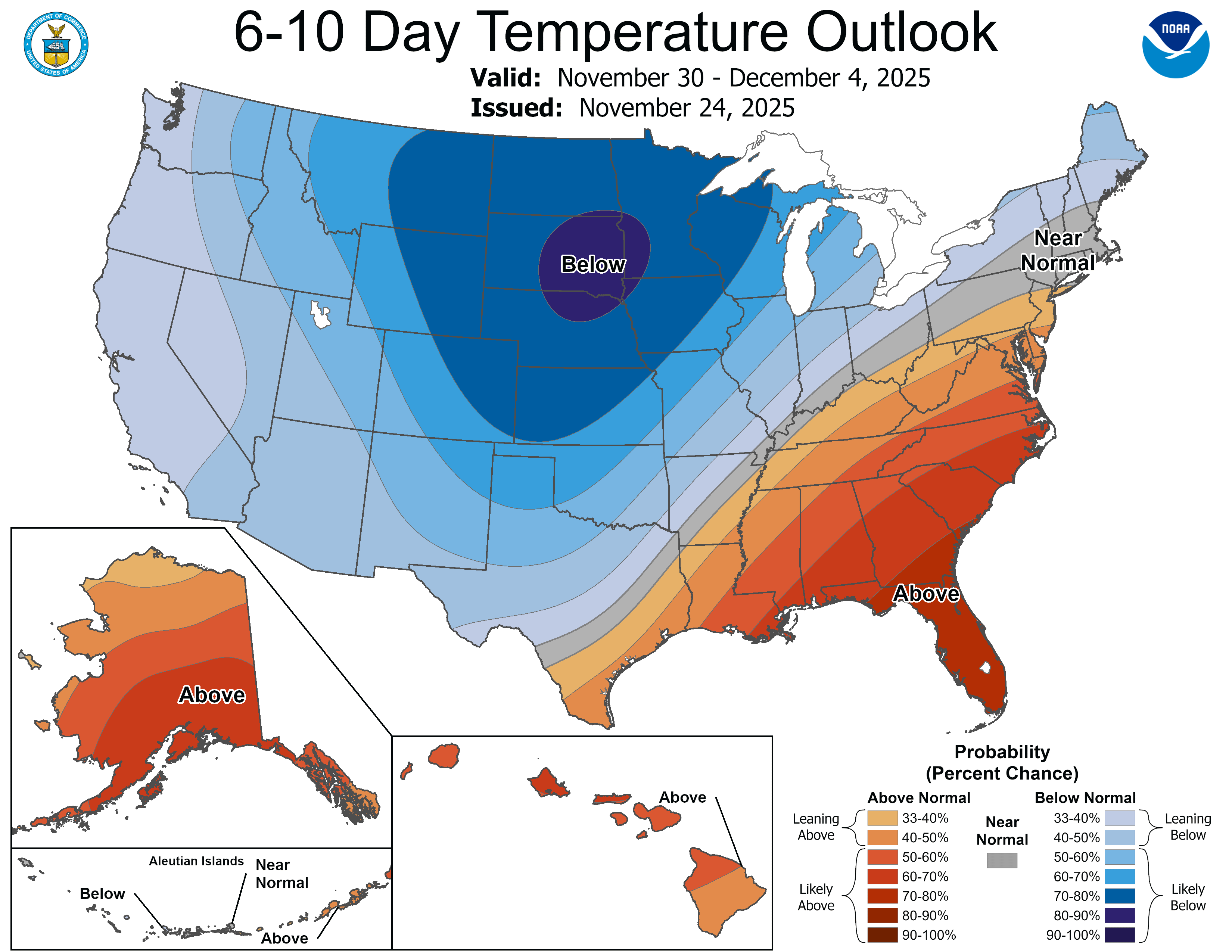
This will increase the magnitude of the usual meridional temperature gradient from colder than average north and warmer than average south.
Any slight shifts north or south will carry with them big changes in individual HDD forecasts from the models because of such a steep temperature gradient.
This will also cause huge temperature swings, especially close to the center of the tight gradient. Southerly winds ahead of a weather system will tap the unseasonable warmth. Northerly winds on the back side will pull down some Arctic Air that dropped all the way thru Canada and was dumped south of the border.
Here's an example of highs next Sunday: 70's in the Deep South, teens in the N.Plains.
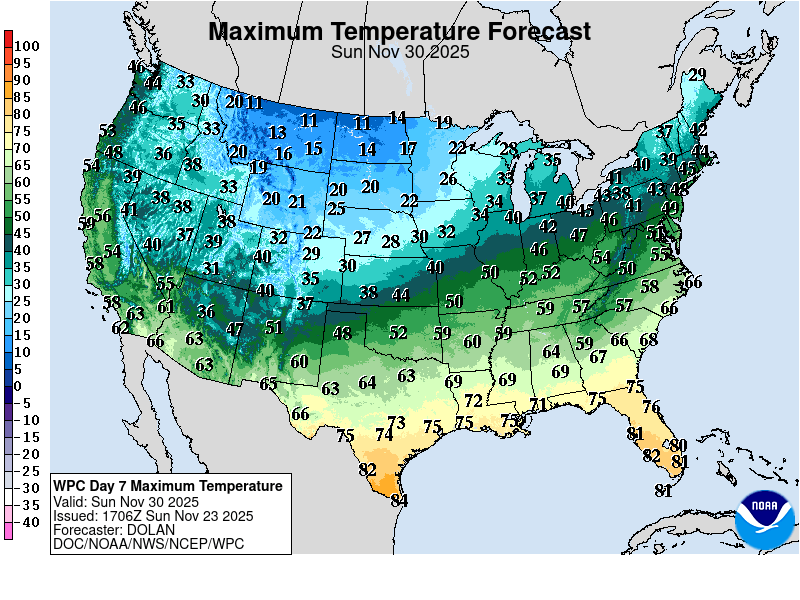
This was the last NWS week 2 forecast:
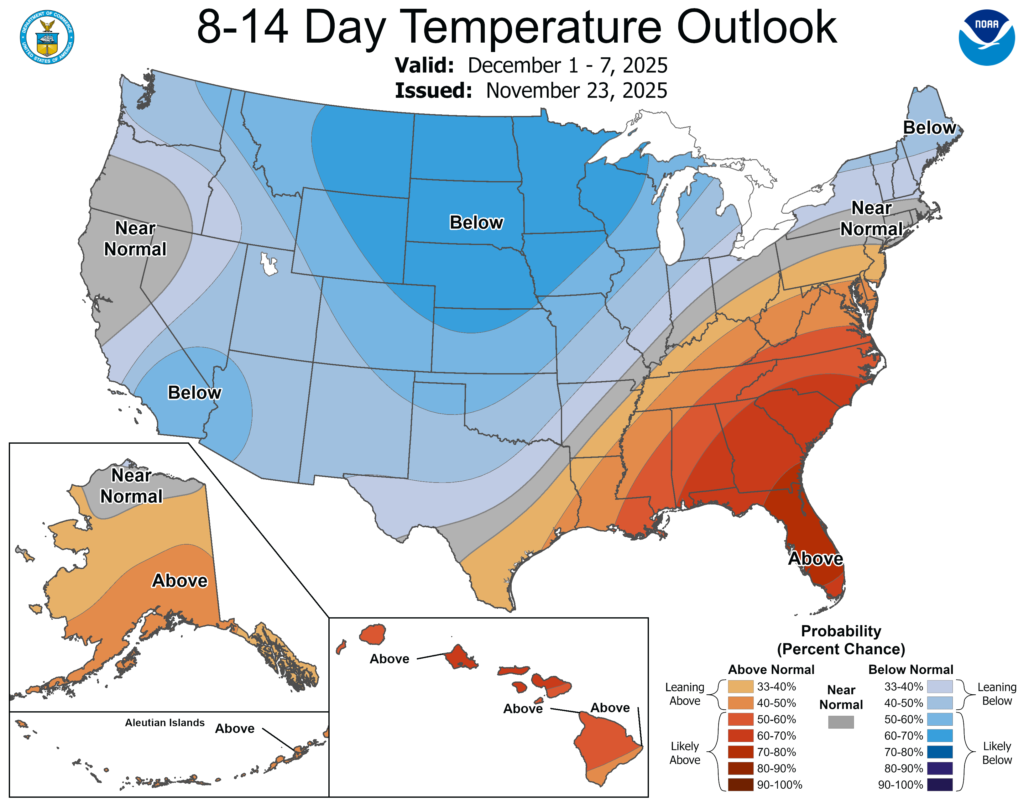
Look at the extreme temperatures coming up!
Extremely colder than average in the places that already usually have the coldest temperature in early December. Extreme warmth in the places that usually have some of the warmest weather in early December.
Greatly amplifying the typical tight/steep temperature gradient from northwest to southeast.
https://www.marketforum.com/forum/topic/83844/#83852
Looky here on the last 12z European control model snow totals THE NEXT WEEK.
10"+ just north of Evansville IN! This is an outlier, so it probably won't happen…..IN EVANSVILLE. But the storm is coming!
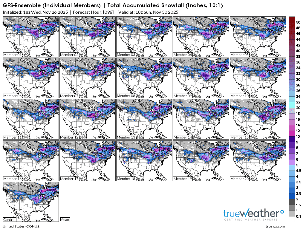
2 week snows from the last 18z GEFS model. This is much higher confidence.
++++++++++
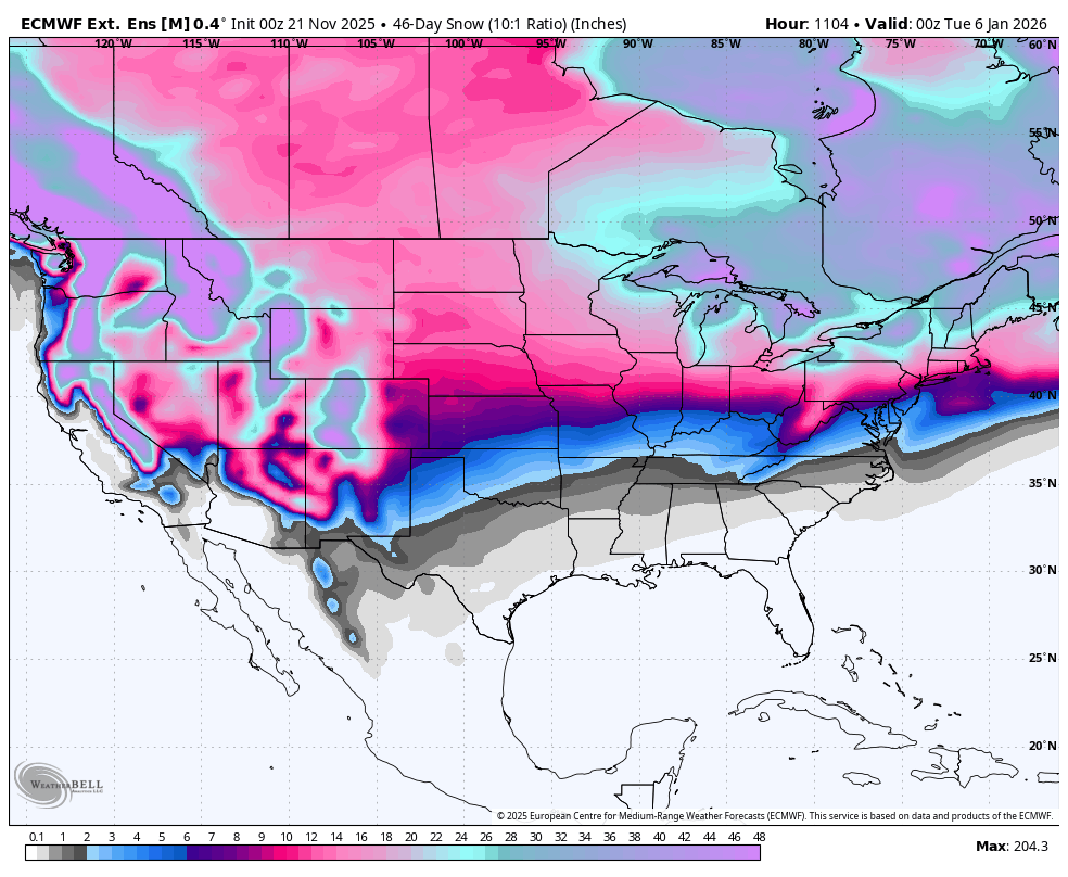
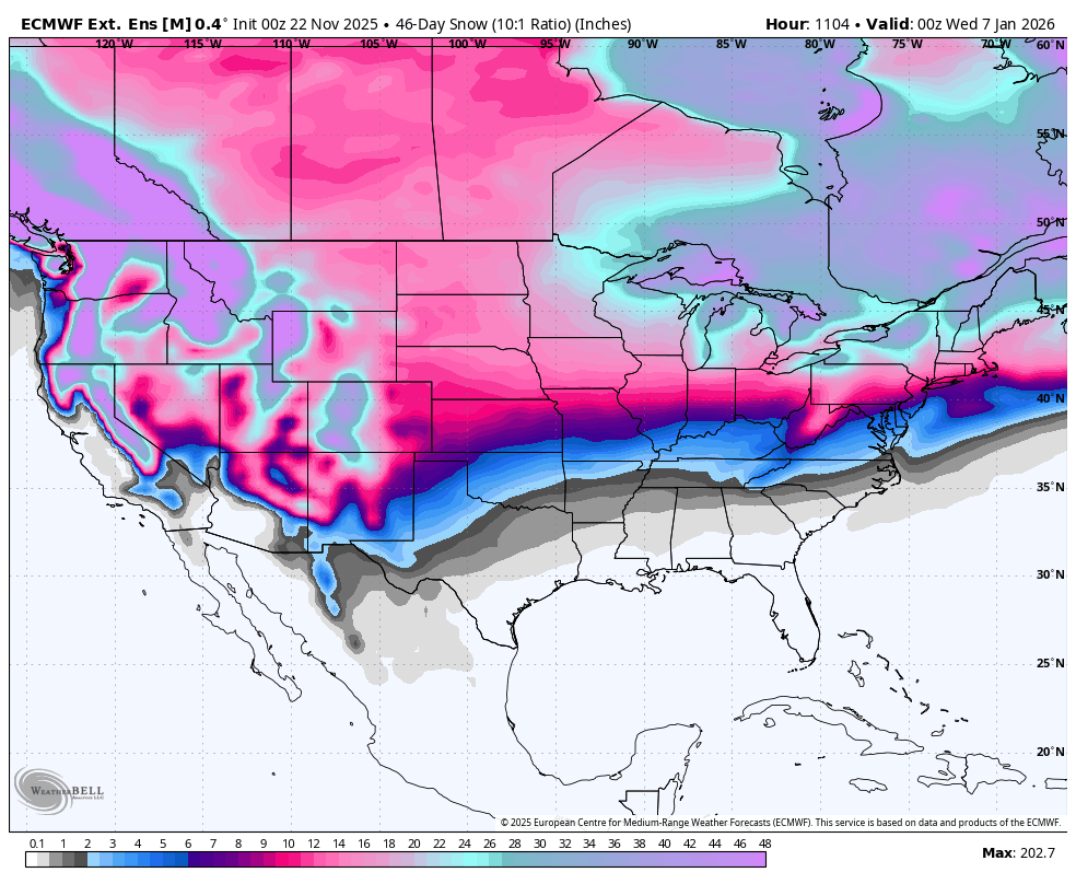
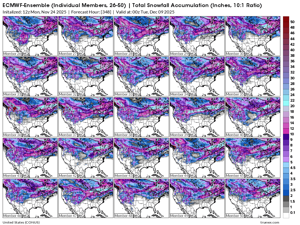
Back to the European Ensemble model and some of the individual solutions for total snow the next 2 weeks so you can see variations in snow fields that get dumped from individual storms/perturbations.
The northern 1/3rd is high confidence for being targeted for getting accumulating/significant snows. Probably numerous events.
The last couple of days have featured a major pattern change in week 2 to something that's almost the opposite of the real cold on the next week.
1. The first map of 72 hours, shows a very cold couplet with strong positive anomalies in Alaska and a negative anomaly in the Northeast US. This is ideal for cold air to be delivered from high latitudes to the mid latitudes.
2. The map below that shows the complete opposite although the magnitude of the anomalies is very modest. Cold air will stay trapped in the higher latitudes.
3. Temperature anomalies will be dominated by mild Pacific air masses that spread zonally from west to east. The East should get this milder air later in the period.
https://www.psl.noaa.gov/map/images/ens/z500anom_f072_nhbg.gif
NCEP Ensemble t=72 hours below.
https://www.psl.noaa.gov/map/images/ens/ens.html#nh
NCEP Ensemble t = 360 hour forecast 
NCEP Ensemble t = 360 hour forecast 
++++++++++++++++++++++++++++++++++++
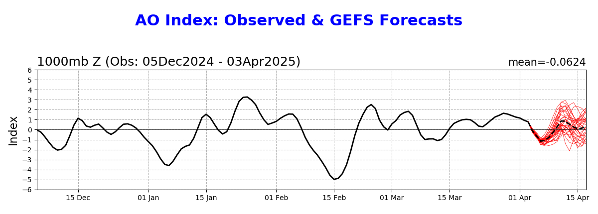
4. Arctic Oscillation will be INCREASING to near +2. This is UNfavorable for high latitude cold to reach the middle latitudes.
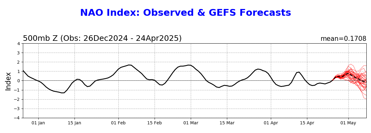
5. North Atlantic Oscillation will increase to positive. UNfavorable for cold in the Midwest/Northeast.
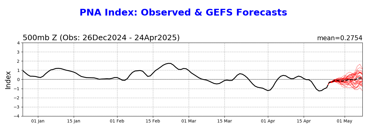
6. PNA will decrease to around -1. This is also UNfavorable for cold air masses to penetrate very deeply into the US.
Arctic Oscillation Index, North Atlantic Oscillation Index, Pacific North American Index.
https://www.cpc.ncep.noaa.gov/products/precip/CWlink/daily_ao_index/ao.shtml
https://www.cpc.ncep.noaa.gov/products/precip/CWlink/pna/nao.shtml
https://www.cpc.ncep.noaa.gov/products/precip/CWlink/pna/pna.shtml
Most of these maps are updated daily so that analysis at the top will no longer be valid in the days ahead when they change.
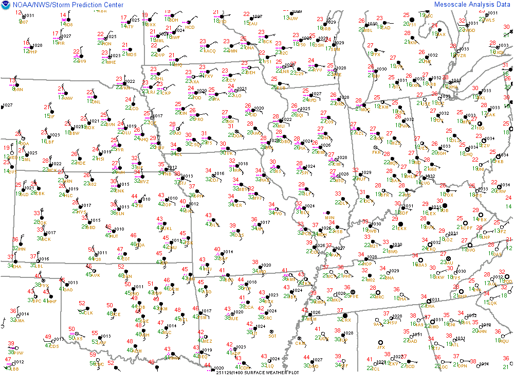
I've been completely neglecting the current weather!!!
That's really deep low pressure storm system!!!
We can see the extremely tight pressure gradient cause very strong winds!
Driving down some very cold air on the backside!
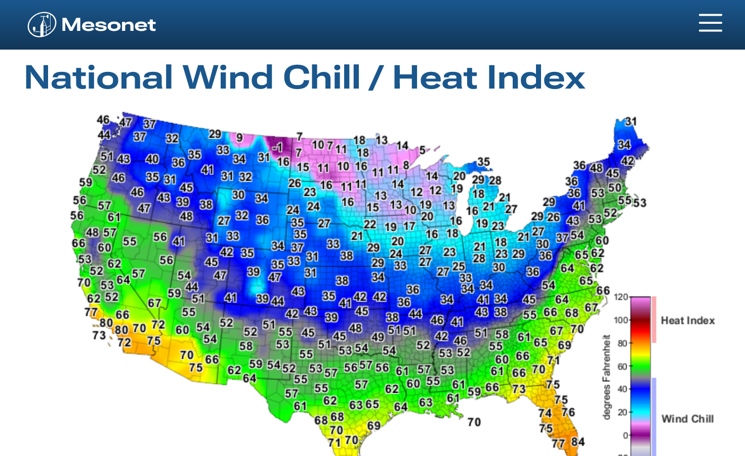
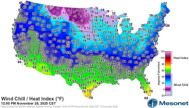
https://www.mesonet.org/weather/air-temperature/national-wind-chill-heat-index
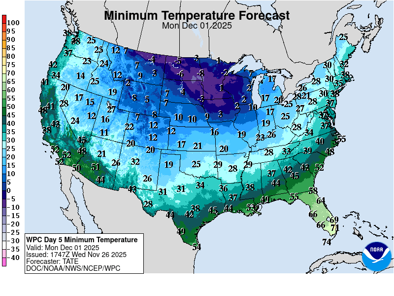
Cold air will be increasing and dumping in the last several days. Monday looks like the coldest morning with below 0 lows in purple. Making it colder will be the deep snowpack on the ground in some places.
This is the total snow the next 5 days.......thru the weekend:
Total snow the next 2 weeks.
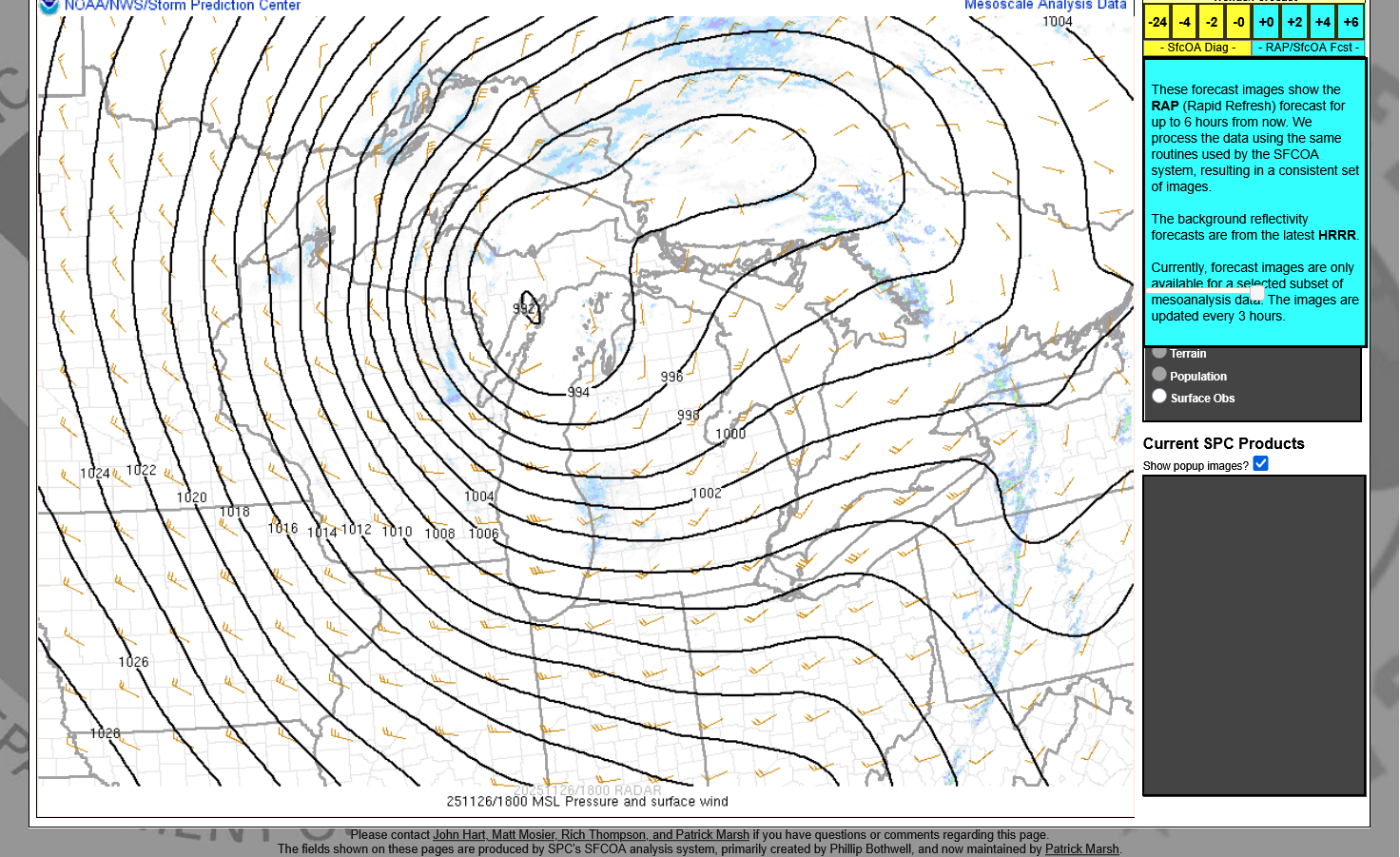
We can use the map to track the weather across the country:
Current Hazards at the link below.
For your NWS and county, go to the link below.
Then you can hit any spot on the map, including where you live and it will go to that NWS with all the comprehensive local weather information for that/your county.

Here's what the colors on the map above stand for: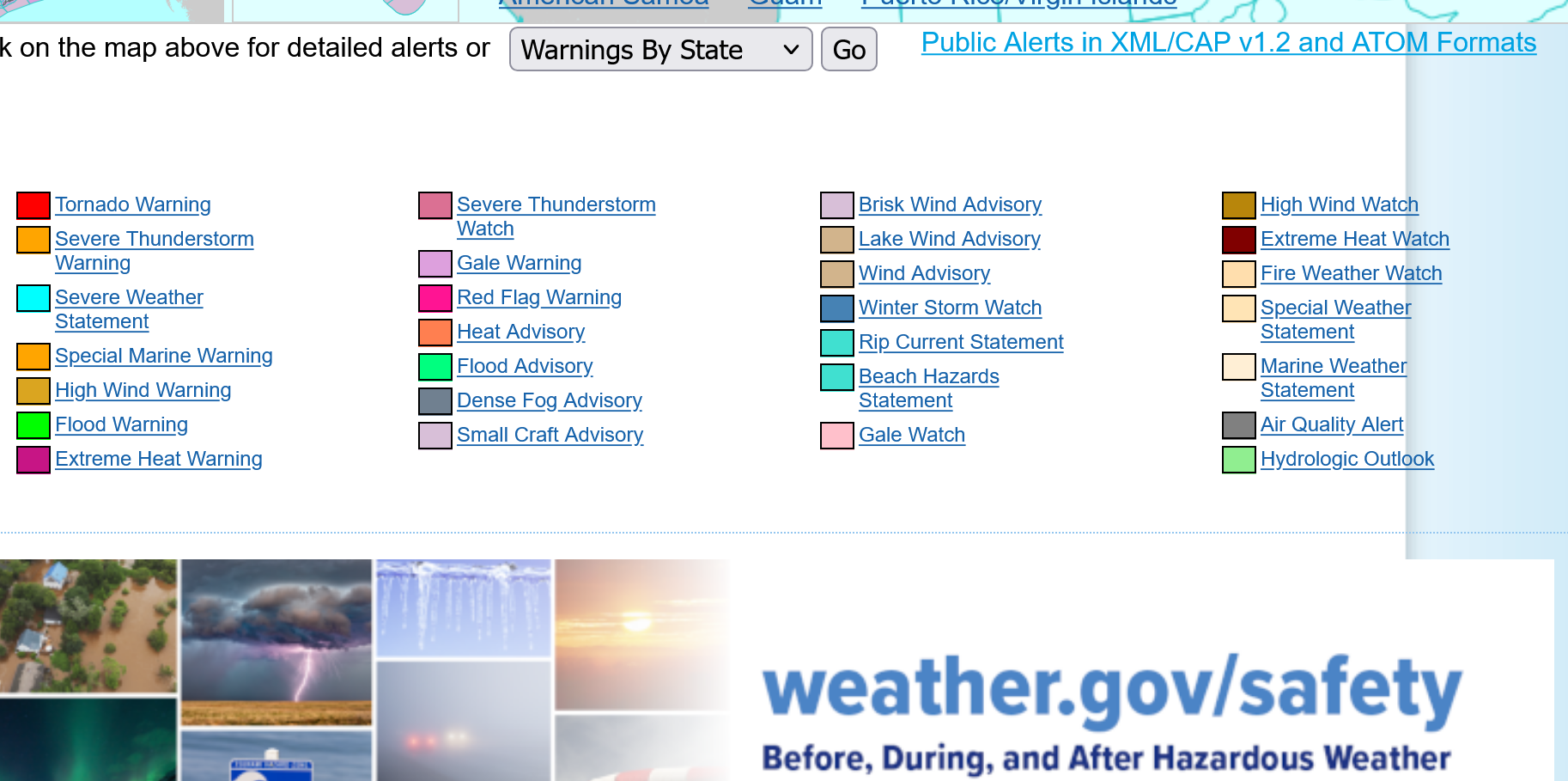
+++++++++++++++++++++++++++++++++
This last run of the 18z GEFS has several ensemble members(still a minority) with the accumulating snow all the way down to the Ohio River. These are just the first 20 individual solutions. The ensemble models average dozens of these individual solutions and come out with an average. The average has higher skill than any individual solution and better than the individual, main operational GFS model. Part of the better skill is it averages out the outliers/extremes which are least likely to verify but sometimes catch on to something first/better than all the other members. The trend has been to shift the snow amounts farther southeast with time but it still looks too warm on the southeast side of the storm for us to keep much snow along the Ohio River.
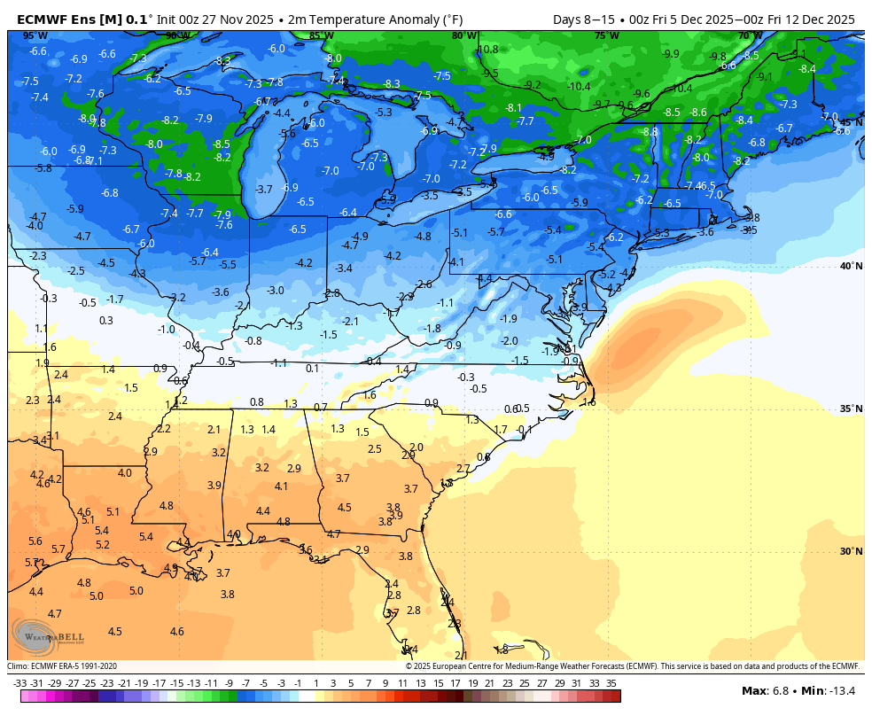
With today’s unfavorable changes in the MJO and AO/NAO, today’s 0Z GEFS is not surprisingly significantly warmer than yesterday’s run for early Dec. However, today’s 0Z EE, which unlike the GEFS maintained its very long phase 8, is much colder than yesterday as well as the GEFS:
Yesterday’s 0Z EE for 12/5-11 2m temps:
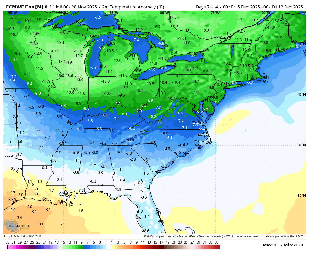
Today’s 0Z EE for is much colder for 12/5-11:
Excellent post, Larry!
The models, just like in August/start of September keep deepening troughs in the Northeast sector with time because they unable to forecast them with much skill.
If you want to make a forecast colder, with more HDDs in the Winter, deepen a trough in the Northeast.
+++++++++++++
I especially liked your reasoning because I've not been following the MJO this week and learned something from you.
Thanks!
Several more cold waves like this coming the next week!
This is the La Nina temperature analog, almost exactly!
https://www.mesonet.org/weather/air-temperature/national-wind-chill-heat-index
+++++++++++
https://www.cpc.ncep.noaa.gov/products/predictions/long_range/lead01/off01_temp.gif
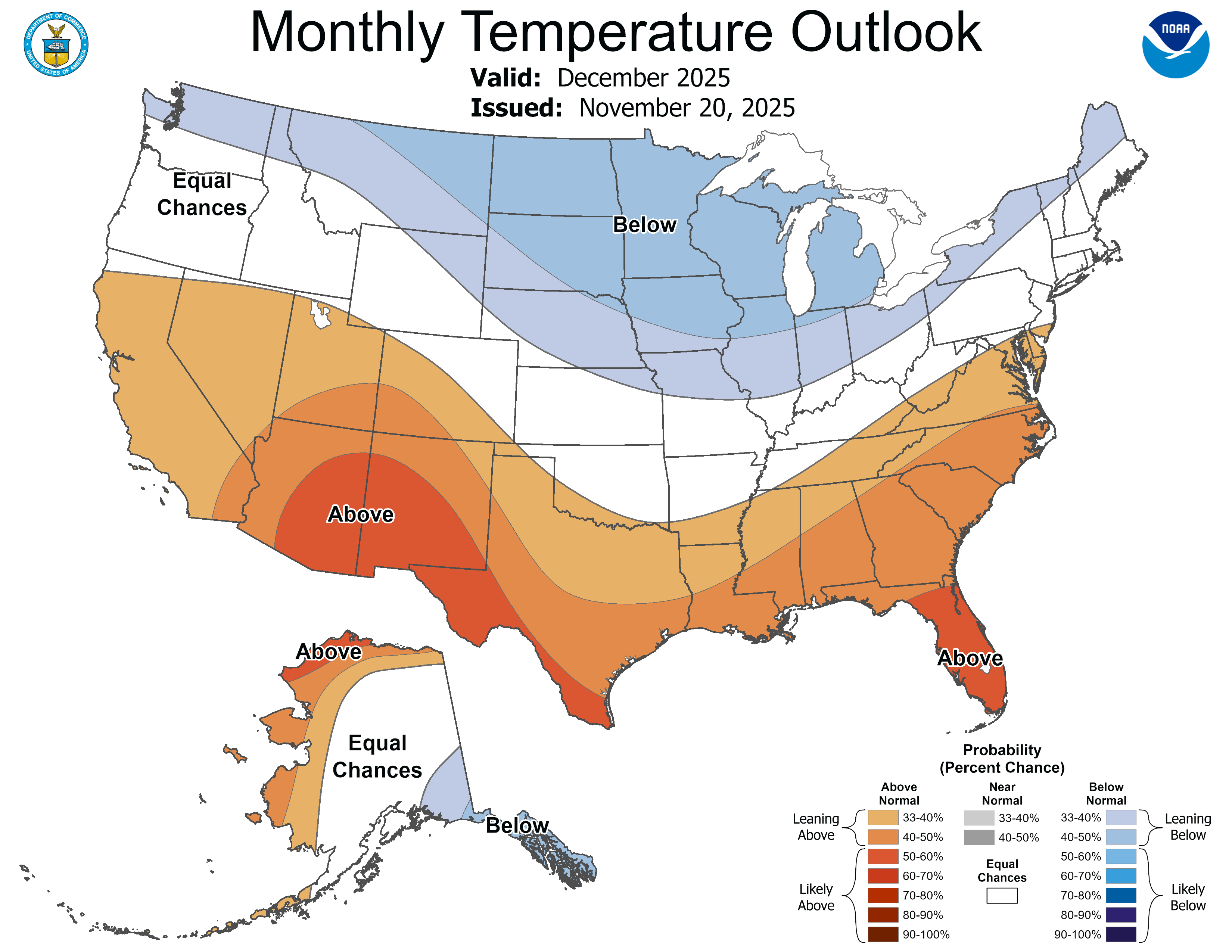
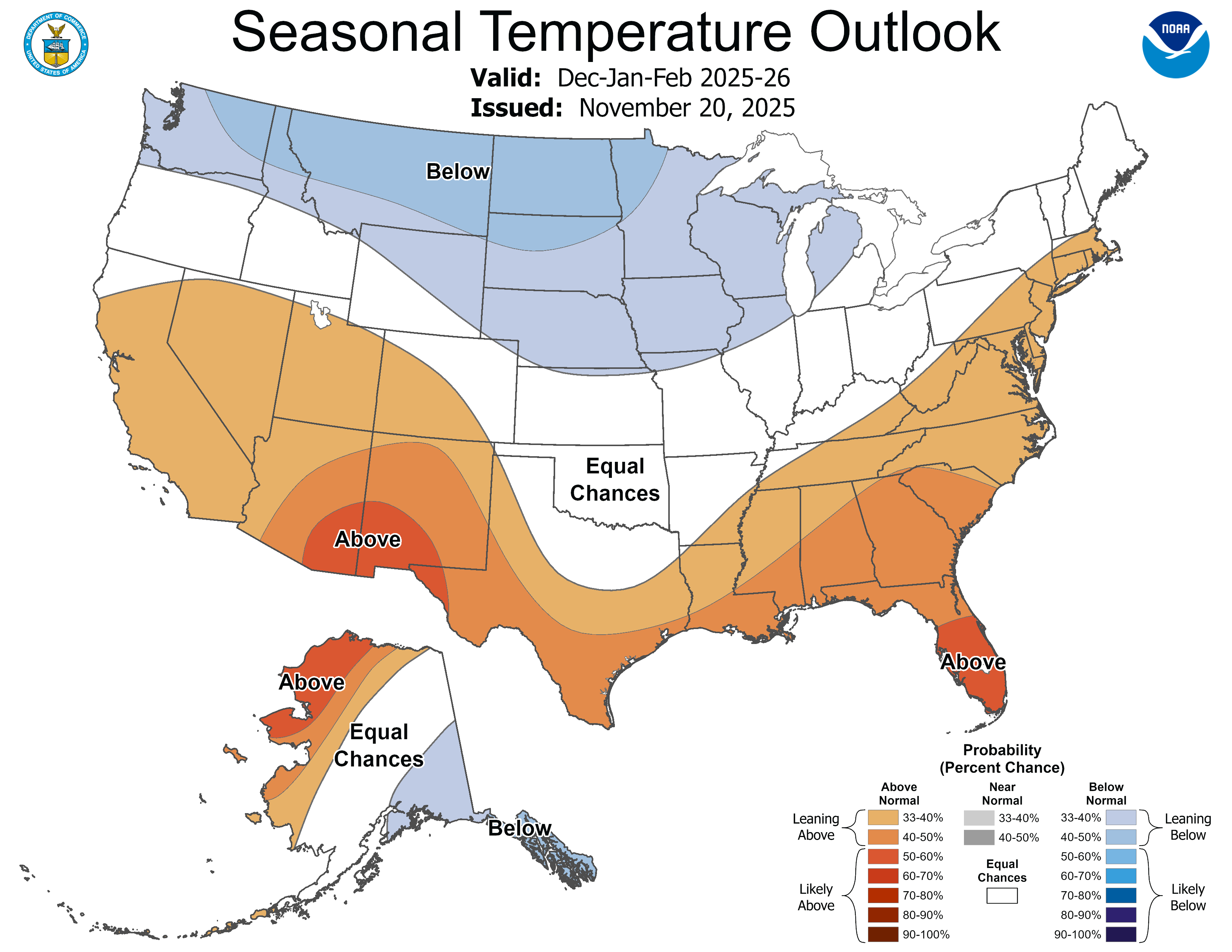
NWS 1 month, December forecast updated last week. 3 months below that.
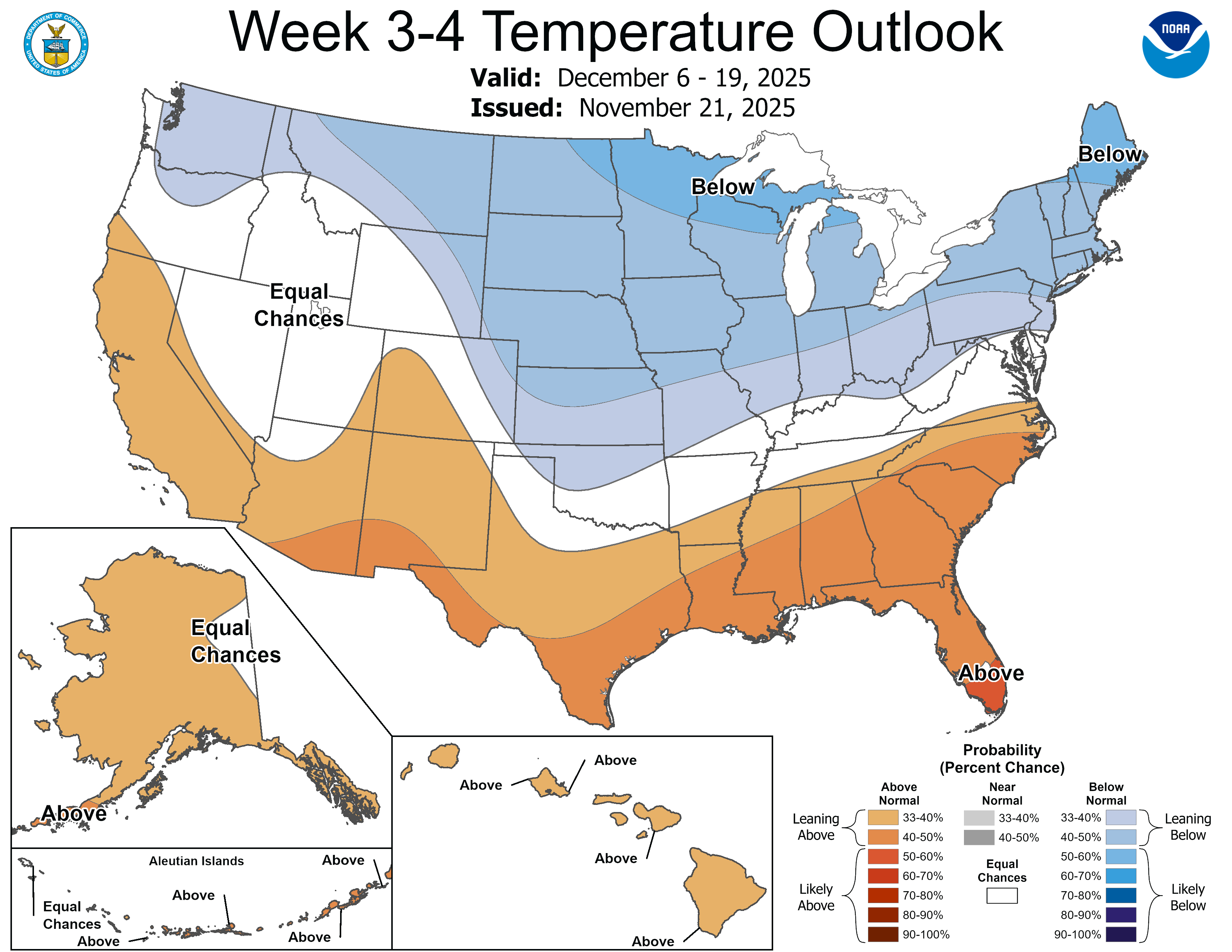
This was the just updated weeks 3-4 outlook.
Below normal in the coldest places, above average temperatures in the warmest place.
This is the recipe to maximize the temperature gradient from north to south. Slight shifts with storms or the jet stream can make a difference of double digits in daily temperature outlooks in the places within the steepest gradient.
https://www.cpc.ncep.noaa.gov/products/predictions/WK34/
Total snow expected from the current system:
https://www.wunderground.com/maps/radar/current

Current Hazards at the link below.
For your NWS and county, go to the link below.
Then you can hit any spot on the map, including where you live and it will go to that NWS with all the comprehensive local weather information for that/your county.
LOWER MIDWEST
https://www.spc.noaa.gov/exper/mesoanalysis/new/viewsector.php?sector=20

Get all the weather here: