Previous Winter weather thread:
11-21-25 Much colder pattern coming up!
Started by metmike - Nov. 21, 2025, 3:17 p.m.
https://www.marketforum.com/forum/topic/116112/
++++++++++
You can get all the constantly updated, comprehensive weather here:
Weather-UPDATED LINKS
97 responses |
Started by metmike - April 30, 2022, 8:01 p.m.
https://www.marketforum.com/forum/topic/83844/
++++++++++++++
Scroll down for more and enjoy the benefits of living in the best age of human history with all our wonderful technology!
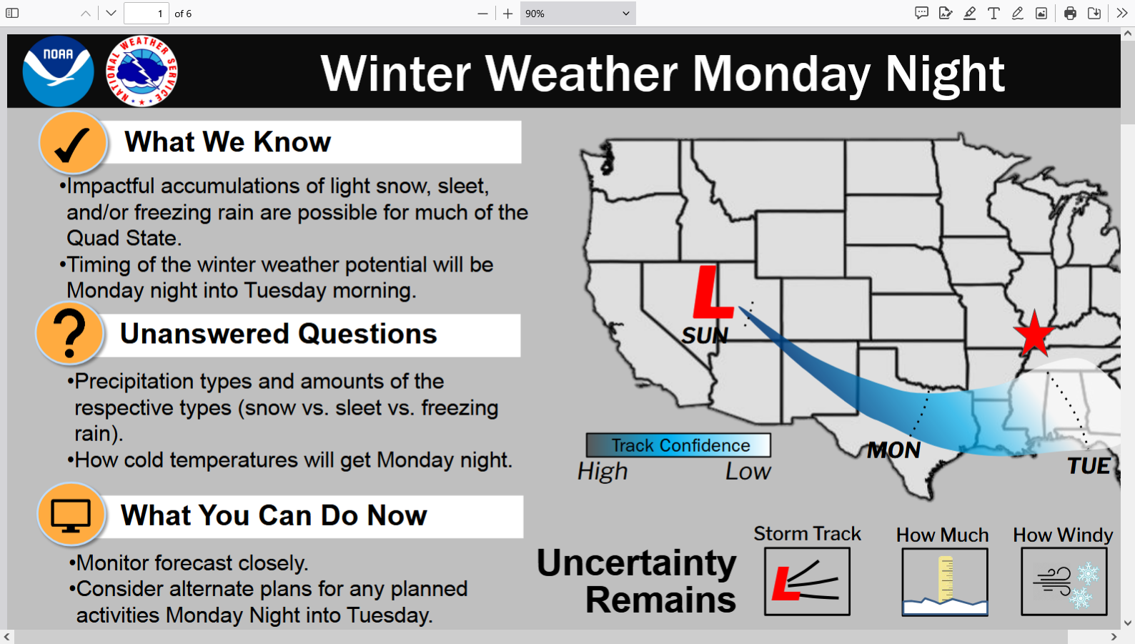
This next system is only going to produce light snow.
1. Very little surface development.
2. Dry air
3. Based on upper level dynamics with a powerful jet streak.
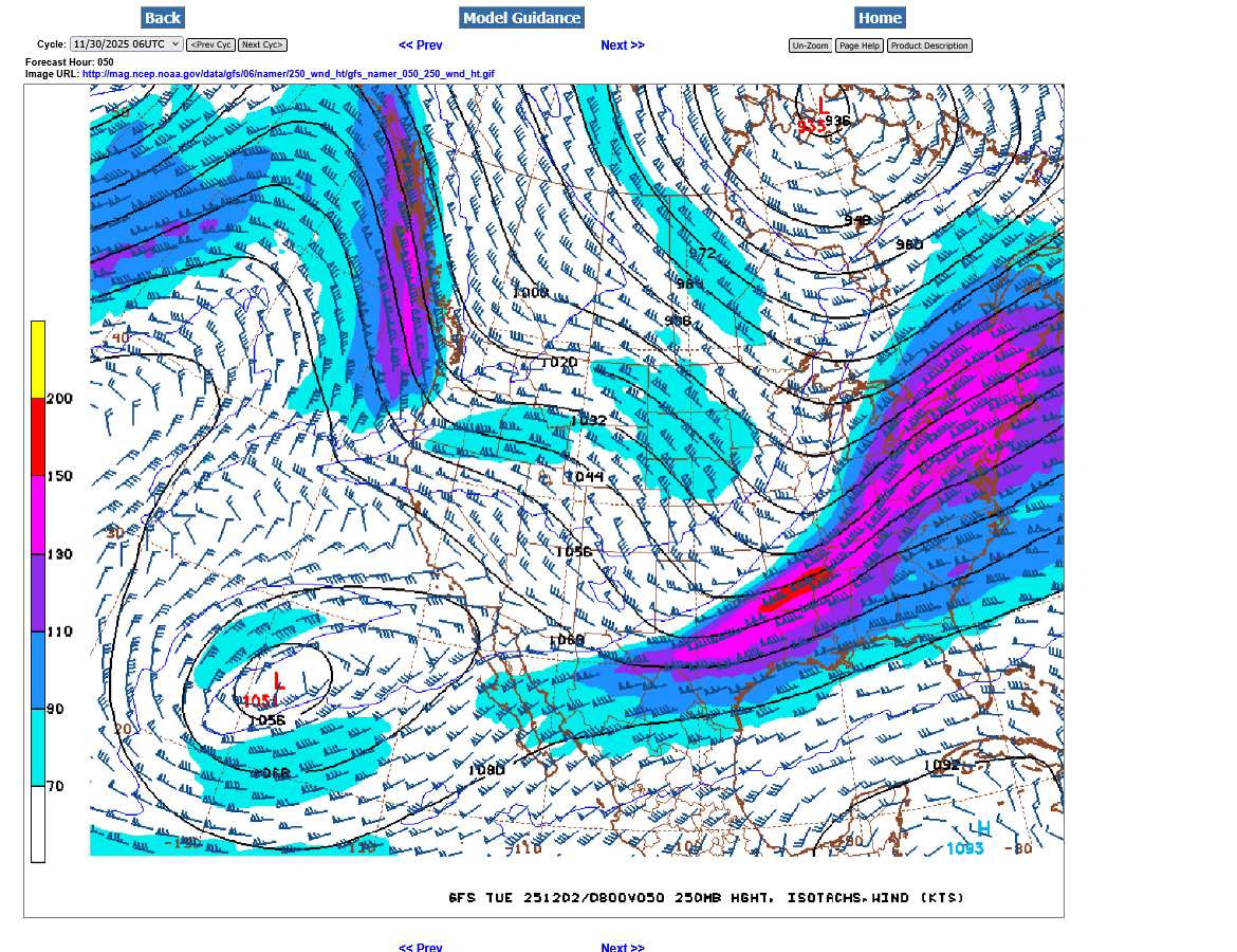
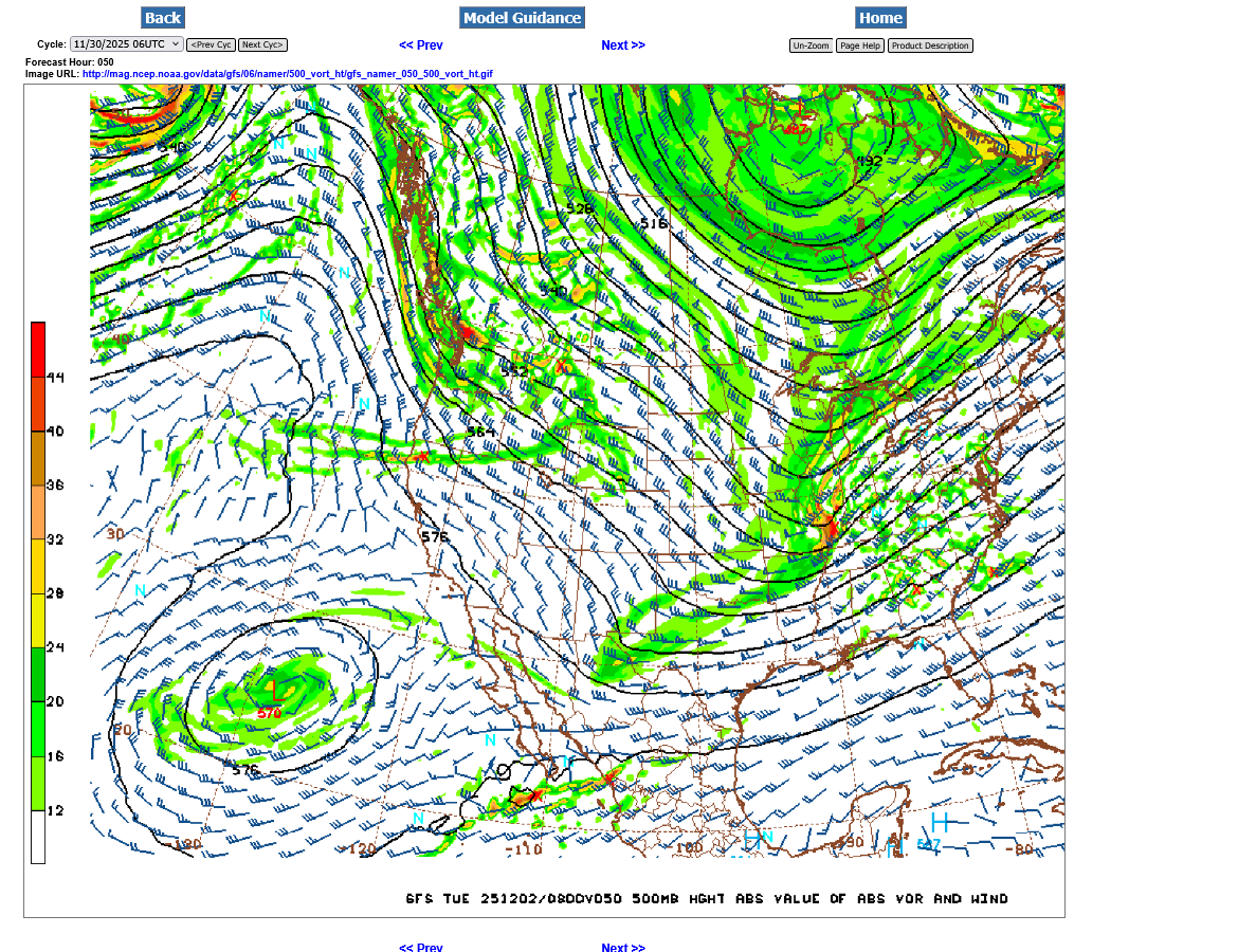
4. First map below. This is the 250 mb level forecast for just after midnight Tuesday. This is around 32,000 feet above the ground and where commercial jets fly! Note the powerful jet stream(in knots). Embedded within the jet stream is a 200 mph jet STREAK in red. This is what will cause the snow from the dynamics related to how the horizontal wind speed change aloft, causes divergence at that level, which results in rising(vertical) air motions below it. Rising air is what causes clouds and precipitation.
5. This is the 500 mb level (18,000 feet up) that shows a distinct vorticity maximum aimed right at Evansville. This is the atmosphere's reaction just below the jet speed max. Vorticity is a measurement of spin/lift in the atmosphere. When it increases, we having rising air motions.
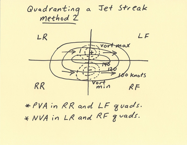
6. Jeff Haby's tutorial on this. He's the best.
| 2 METHODS OF QUADRANTING JET STREAK |
METEOROLOGIST JEFF HABY
https://theweatherprediction.com/habyhints3/748/
Select a tutorial below or scroll down...
++++++++++++++++++++++++++++++++
https://www.weather.gov/source/zhu/ZHU_Training_Page/winds/JetStream_Stuff/300_200_chart.htm
Select A Tutorial Below or Scroll Down
Most people just want to know how much snow is coming and when!
We have that too!
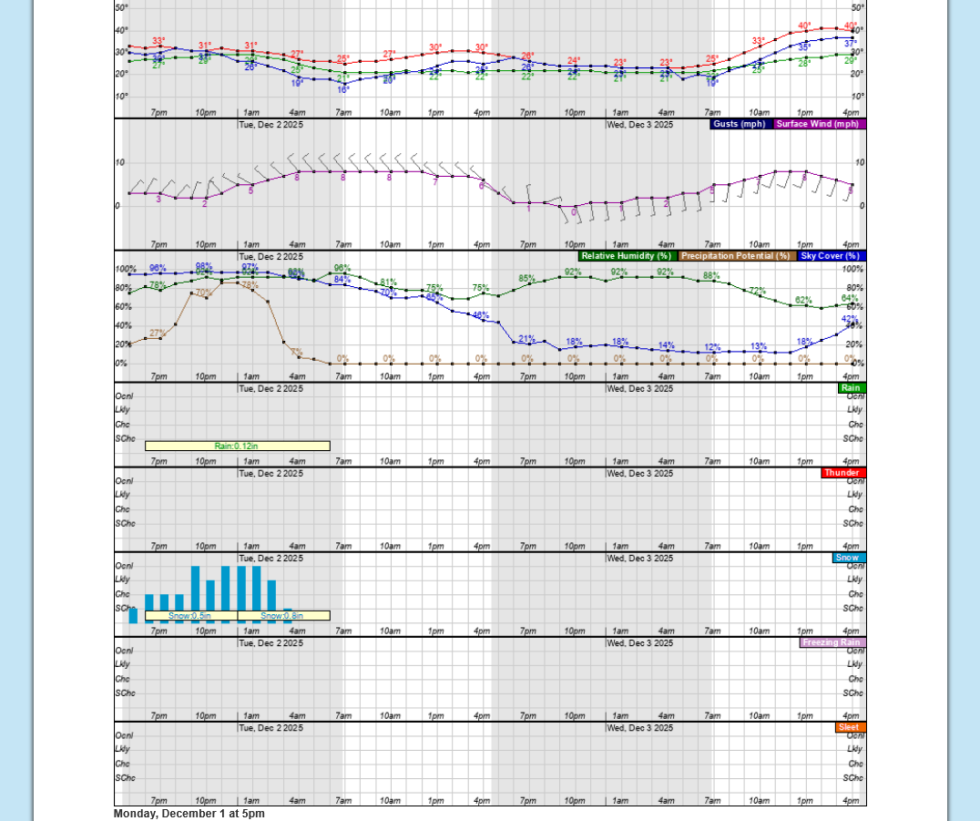
This is the latest forecast from the Evansville NWS, including the numerical forecast broken down into 1 hour time frames:
https://forecast.weather.gov/MapClick.php?x=285&y=85&site=pah&zmx=&zmy=&map_x=284&map_y=85
++++++++++++++++++++
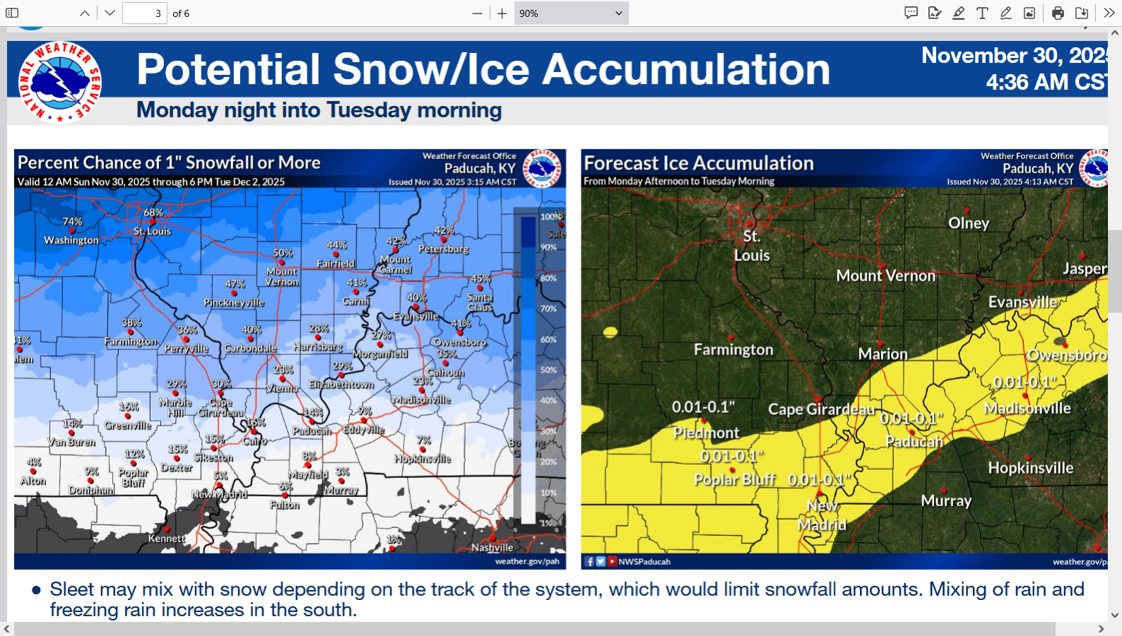
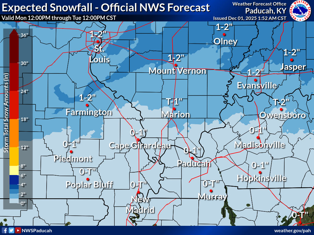
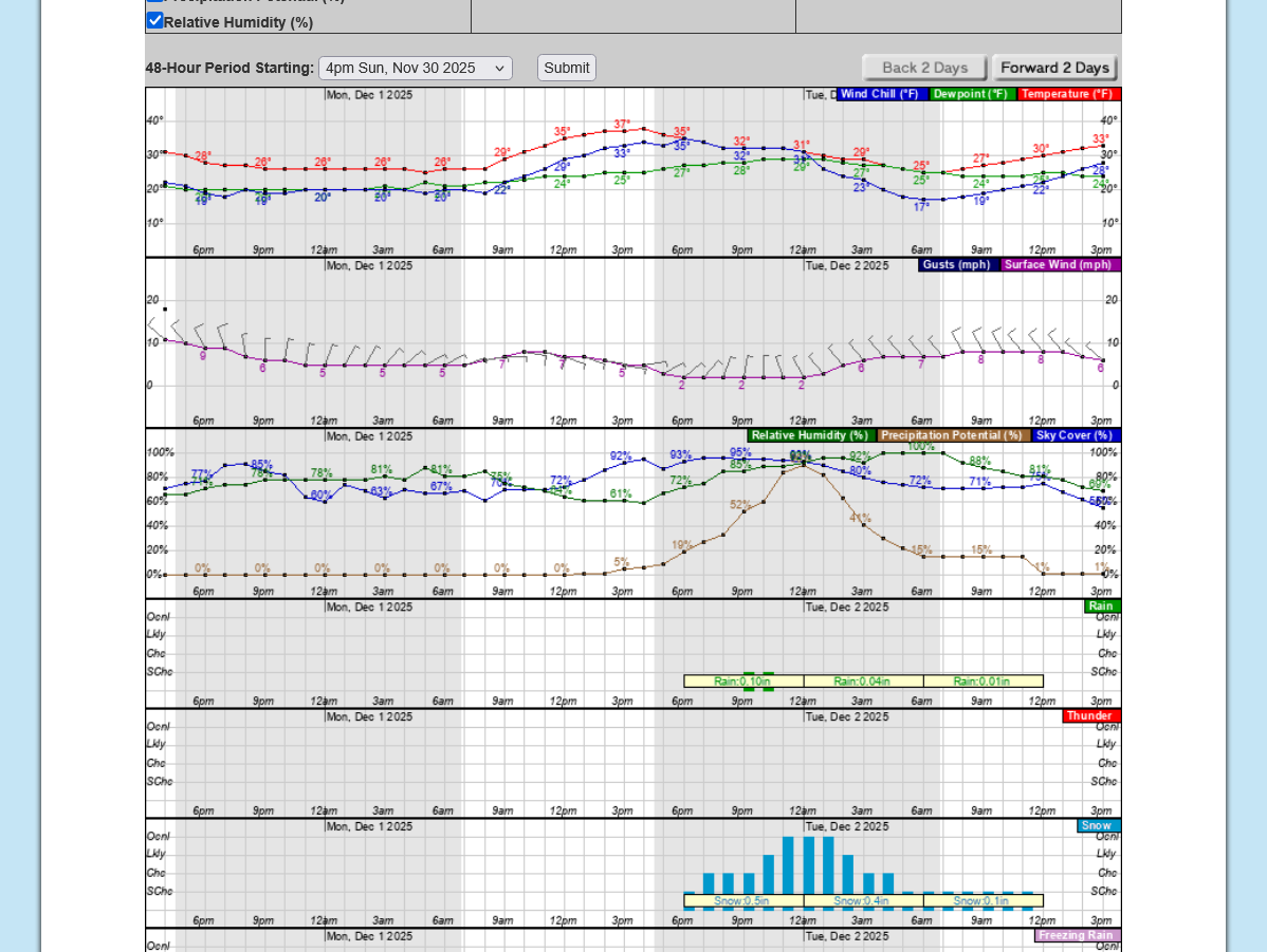
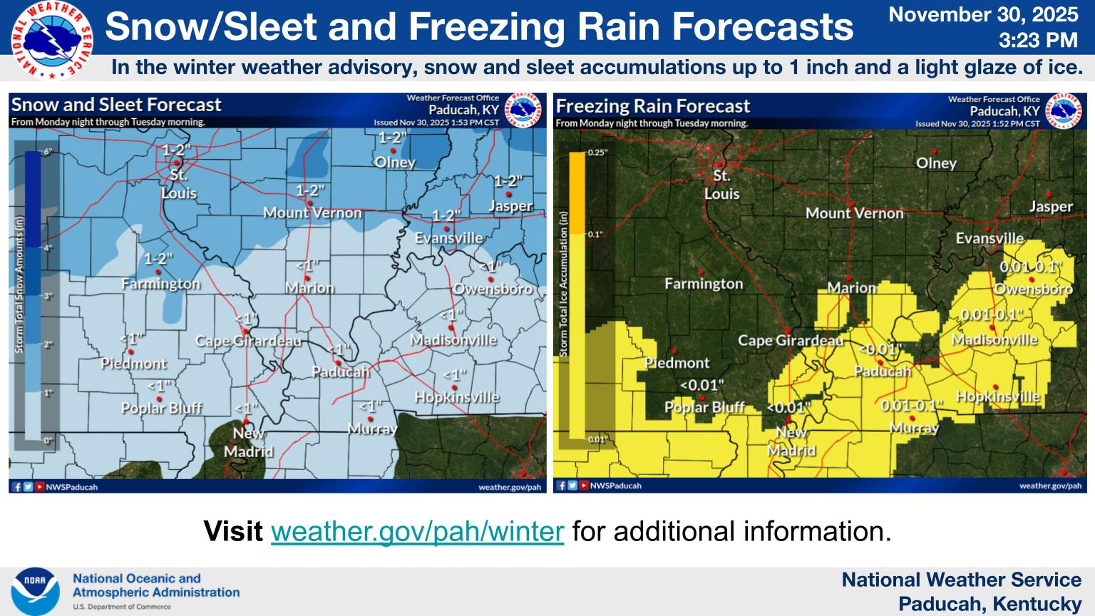
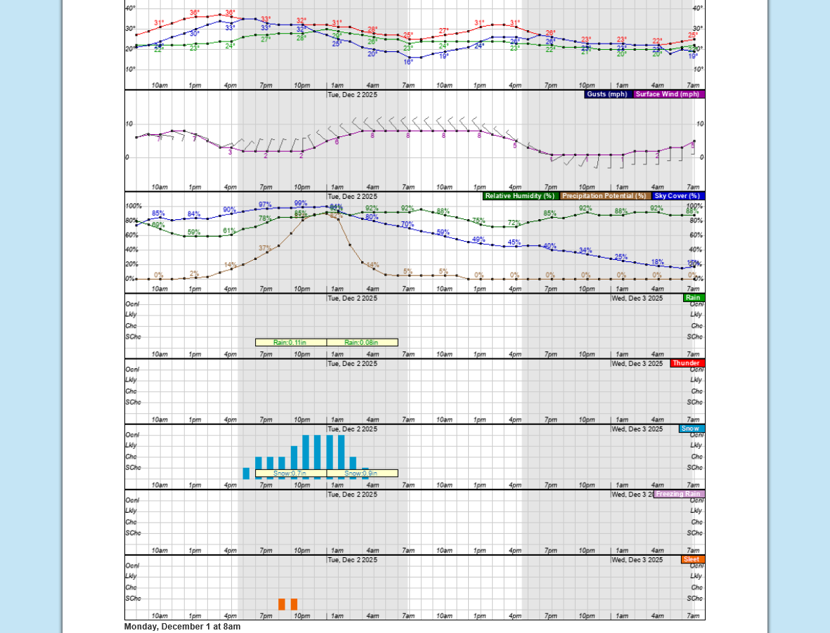
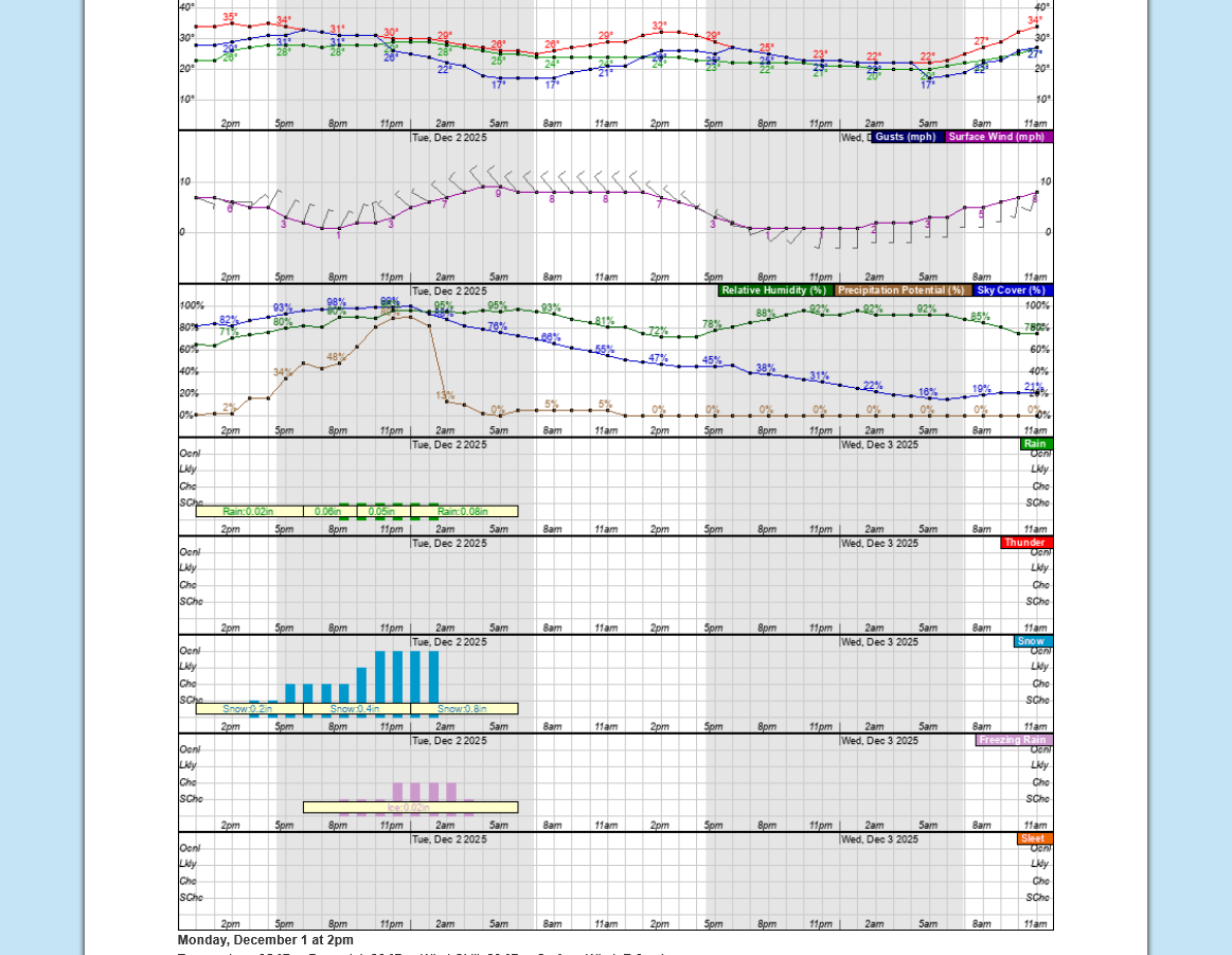
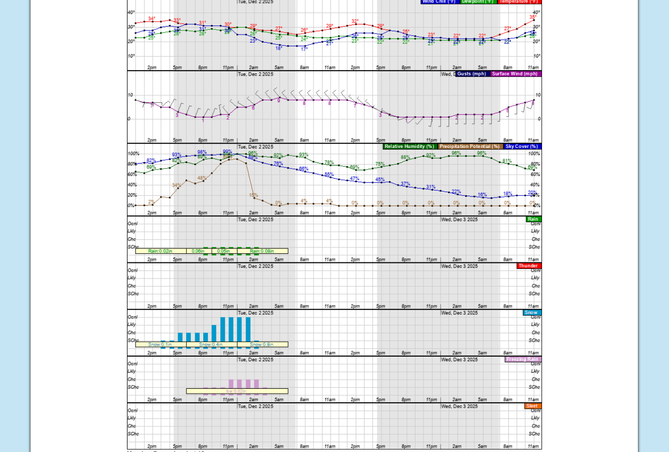
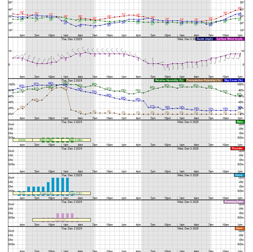
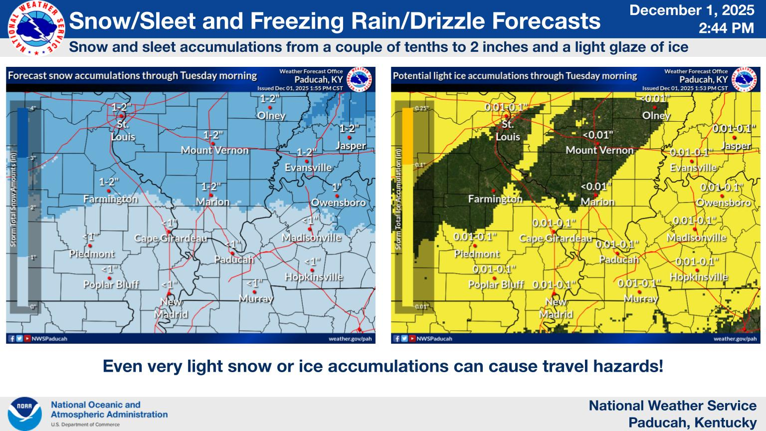
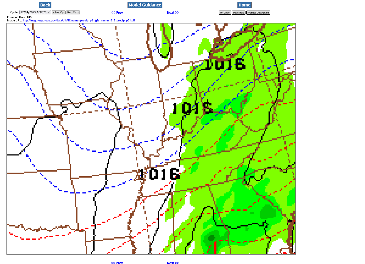
This product predicts 1.0 inch of snow, mainly late Monday evening into very early Tuesday. This is down a tad from the previous model runs(centered around midnight).
That's potentially bad timing for school buses picking up the kids on Tuesday morning. If at least that much falls(especially if more), slick spots on the country roads and side streets could cancel school. Less than that and most of it should melt on the roads and we will be in good shape.
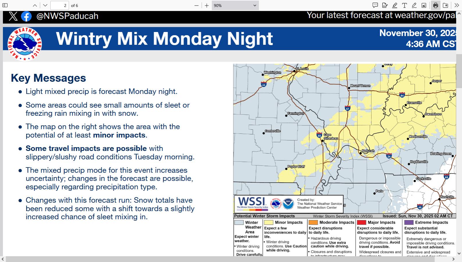
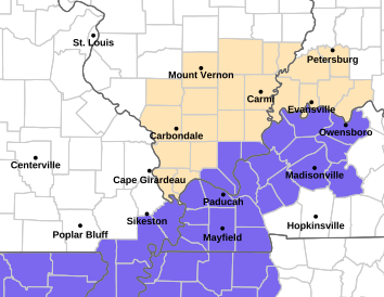
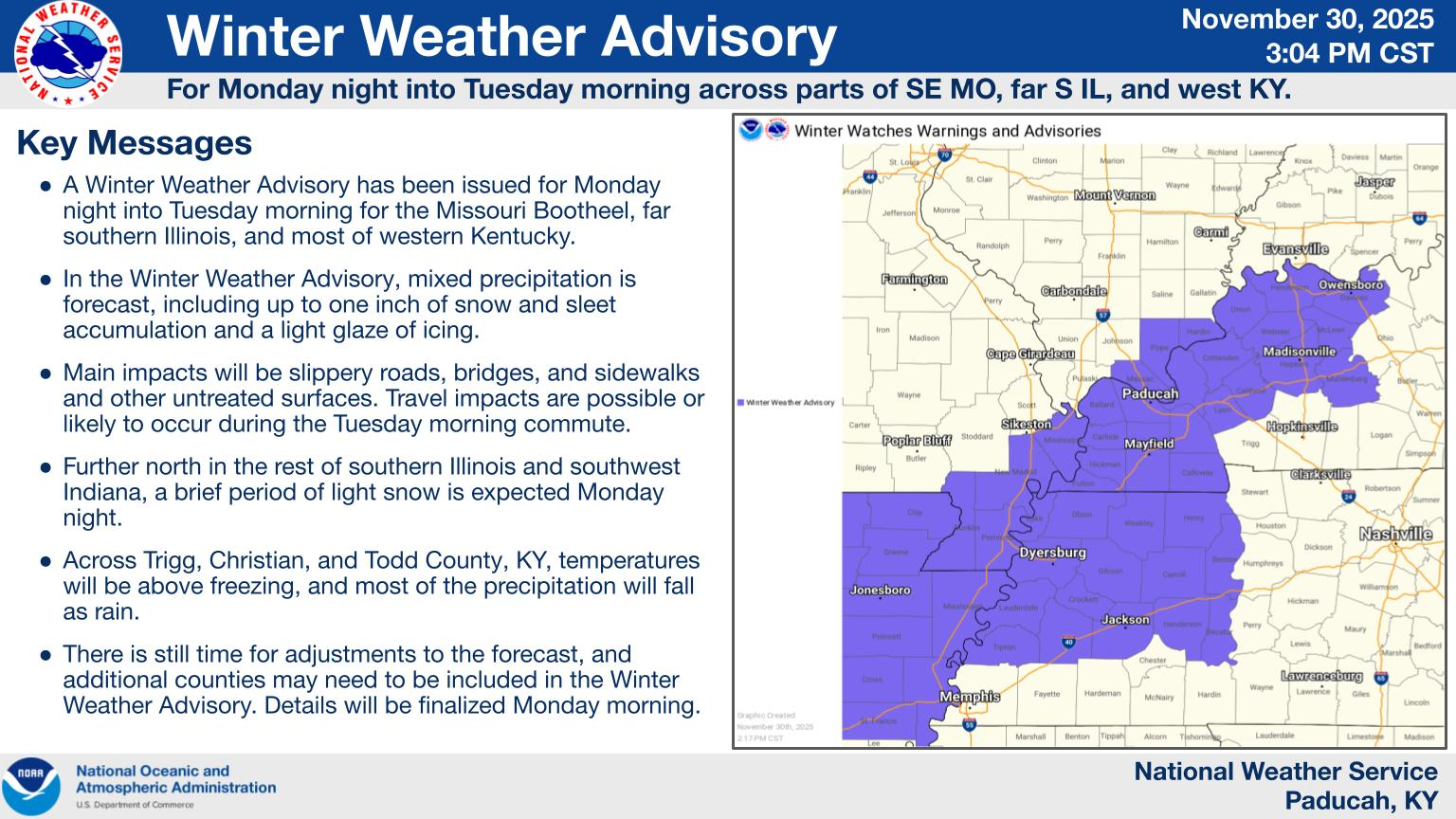
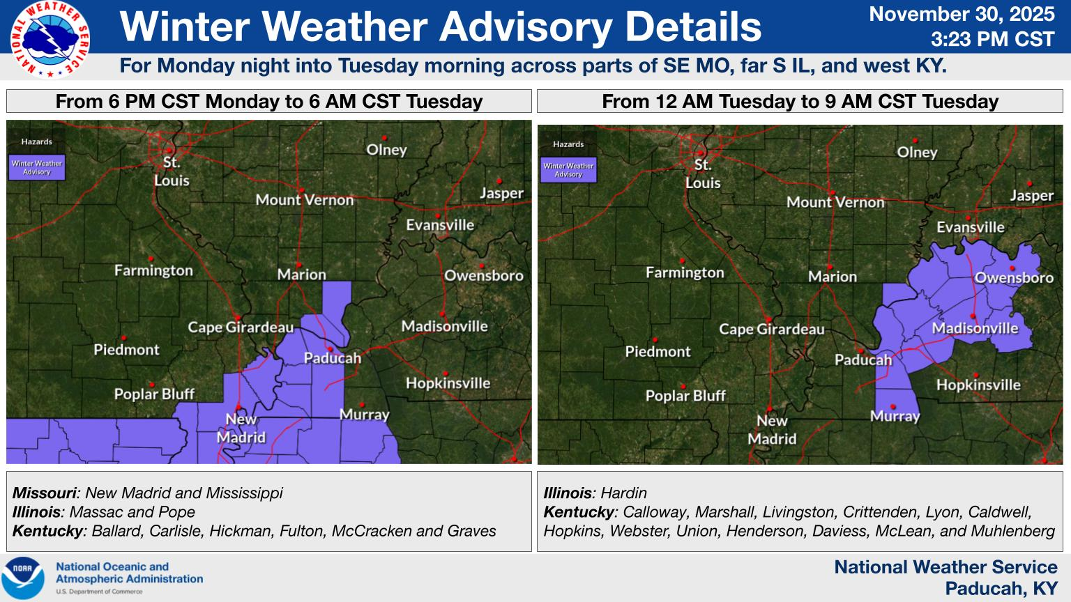
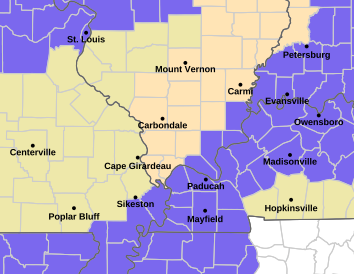
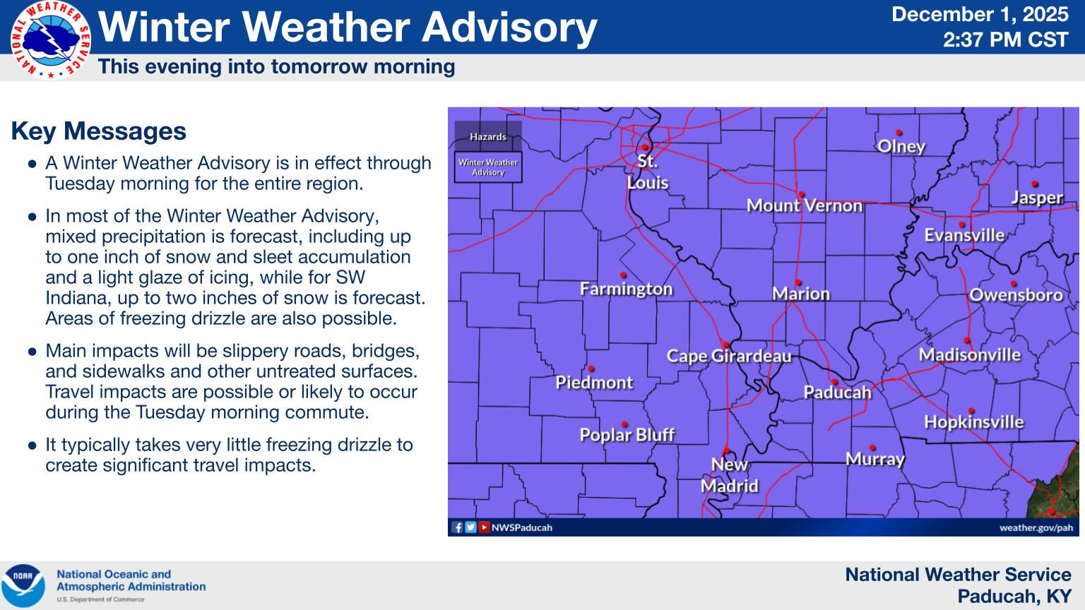
The NWS just issued a Winter Weather Advisory for all the counties shaded in purple. This could be expanded northward when we get closer and confidence in this marginal event is higher.
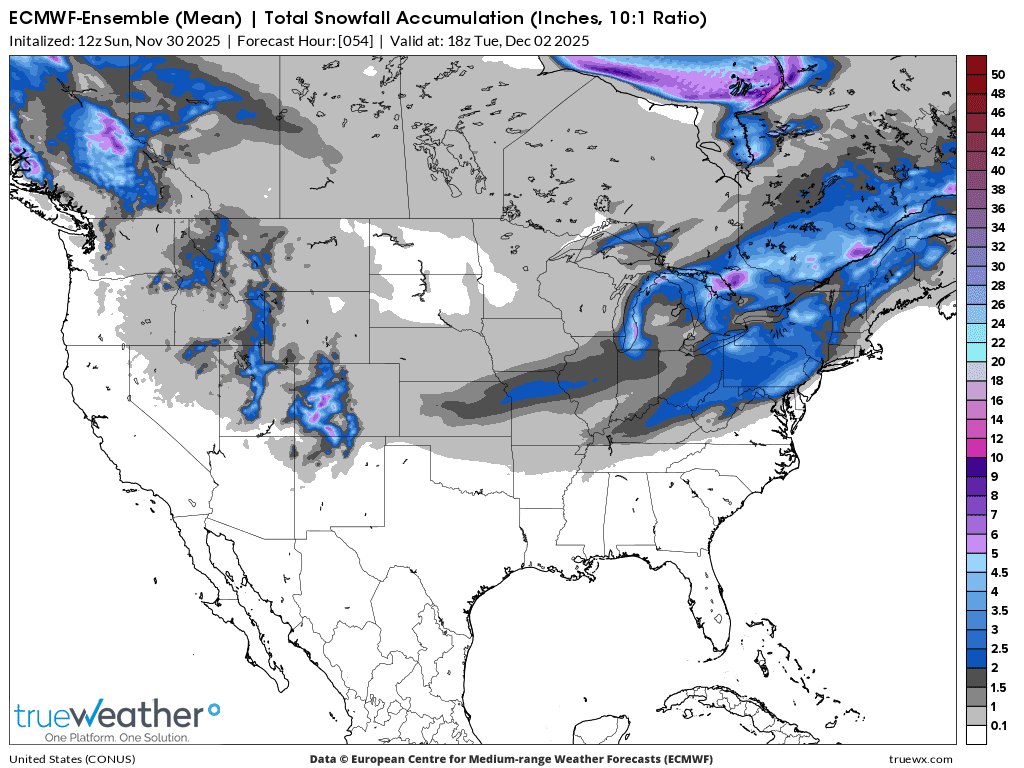
The European Ensemble model does the best at forecasting weather.
This was the last run for predicted snow amounts. That will likely change a bit as we get closer.
This was the last 18z American model.
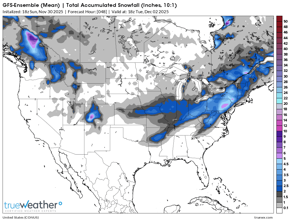
There seems to be support for the heaviest snows to be right along and just south of the Ohio River. Even there, the heaviest amounts look to be under 3 inches.
Much farther east, this storm is likely to organize better and cause heavier snows!
Tracking the light sbow:
Current Hazards at the link below.
For your NWS and county, go to the link below.
Then you can hit any spot on the map, including where you live and it will go to that NWS with all the comprehensive local weather information for that/your county.

https://www.wunderground.com/maps/radar/current

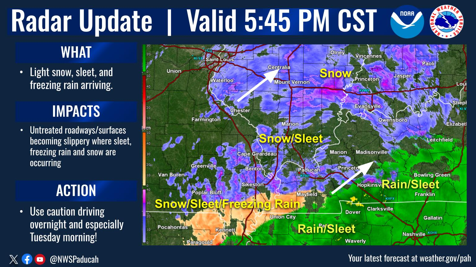
As we speculated yesterday, the weather advisory that was SOUTH of the Ohio River has been expanded northward.
The numerical, computer guidance has boosted total snow amount to 1.6 inches, most of it falling between 9pm to around 2 am.
The question is whether that will be enough time for roads to improve before the kids get on buses? If that much snow DOES fall, I doubt there will be school in Evansville on Tuesday. Side streets and country roads still covered with snow are the recipe for a SNOW day.
That would mean that our chess practice at School School is cancelled too.
If you want to thank/or blame something for tomorrow's SNOW day, this is the feature responsible. We have a 3 year grandson, Cyrus that LOVES snow and are hoping to get him earlier than usual on Tuesday, with hopes that there wlll be snow left on the ground in the afternoon.
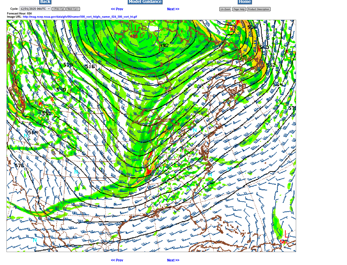
This is the 500 mb map, 18,000 feet above the ground at midnight tonight That blob of yellow/orange is called a vorticity maximum. Vorticity is a measure of spin in the atmosphere, positive vorticity is strongly correlated with lift. Compact vort maxes almost always result in rain/snow below them. There are other factors but this one is a key. Despite no surface development and very little moisture, this feature BY ITSELF is going to produce most of the snow.
A vort max produces most of the precip when its APPROACHING. On the map above, the lines represent the same value (heights for different pressure levels) the wind and vorticity travels parallel to those lines, like the water flows inside the banks of a river(the atmosphere is actually a fluid).
At midnight, we see the positive vorticity hitting Evansville from the vort max. Snow will start when that first starts, a couple of hours before then. After it passes, within a couple of hours the heavier snow will be over.
However, there is still some cyclonic flow left in the trough above that is still west of the vort max. So some light snow is still possible before dawn.
The time stamps at the top of these posts is in EST, which is an hour ahead of us.
The just updated 12z models add a tiny bit of freezing rain in.
Still at 1.4 inches of snow(about the same), much of it will fall between 9pm to 1am, then end abruptly after the vorticity maximum passes to our east but we could see some freezing drizzle or extremely light freezing rain from the upper level trough still approaching and slight warm air advection aloft causing a bit of lift.
VERY LIGHT snow could start by mid afternoon!
That's what the numerical guidance above thinks.
As we get closer, we have something called NOW-casting. The current radar loop suggests the very light snow might get here by mid afternoon, although most of that will be northwest of Evansville.

1pm CST: This is only an hour later but the latest guidance wants to add a tiny bit more light freezing rain/drizzle and take out the snow amounts by that tiny amount. Now down to 1.3 inches.
I see the previous radar loop is NOT updating automatically as hoped for.. Correction: the one above looks different because it's from the Paducah radar. The one below is from the Evansville radar. They are BOTH being updated constantly with the last images.
Most of the snow along the leading edges is not reaching the ground. It's drying up in the very dry air. Not evaporating(liquid rain/water to gas) but SUBLIMATING which is going from a solid (ice/snow) directly to water vapor/gas. No liquid phase!
https://radar.weather.gov/station/kvwx/standard

The main, slight change from a couple of hours ago below is to convert a tiny amount of the precipitation from snow to very light freezing rain/drizzle.
The total snow is down to 1.1 inches which seems reasonable. We are talking about a total of ~.10 liquid equivalent. Trying to be precise with a tiny amount is very challenging. If an extra .1 falls, which is possible that means 2 inches of snow. It's doubtful we would get more than that, although getting less than an inch would not be a shocker.
It's still possible that amounts will be so light that we end up with school on Tuesday.
What Is Sublimation In Simple Terms? - Weather Watchdog
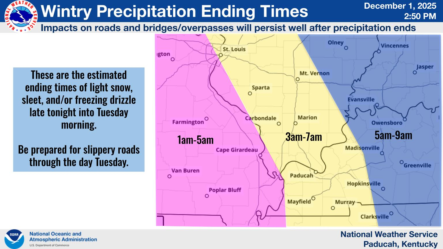
Here's the latest from the NWS. I think this will end a few hours SOONER than their graphic.
https://www.weather.gov/pah/weatherstory
++++++++++++++
Here's the big picture again.
For your NWS and county, go to the link below.
Then you can hit any spot on the map, including where you live and it will go to that NWS with all the comprehensive local weather information for that/your county.
Here's what the colors on the map above stand for:
https://www.wunderground.com/maps/radar/current
The purple color is for Winter weather advisories. Pretty unusual to have so many states covered with snow but almost no WINTER STORM warnings. That's because the snow will be mostly light with no surface development until this system gets to the East Coast.
The numerical guidance took out the freezing rain/drizzle and bumped the snow back up to 1.3 inches. 9pm to around 1am is when most off it will fall.
This is reasonable(though a tiny amount of freezing drizzle is still possible) and I think the ending time is better than the NWS graphic above. The NWS does an awesome job so no knock to them!
It should all be over BEFORE 4AM.
We are very fortunate to have a skilled, life saving NWS in this country. The ones in Paducah(our forecast office) do agreat job!
Everything is moving along close to expected. There's still an outside chance of Evansville being in a dry slot, surrounded by Winter weather but getting less than a half inch of snow and roads being ok in the morning.
That's not my forecast but there's a 15-20% of that happening.
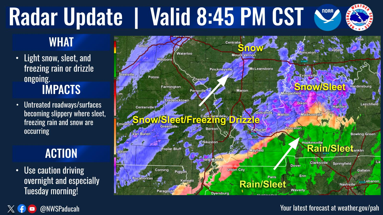
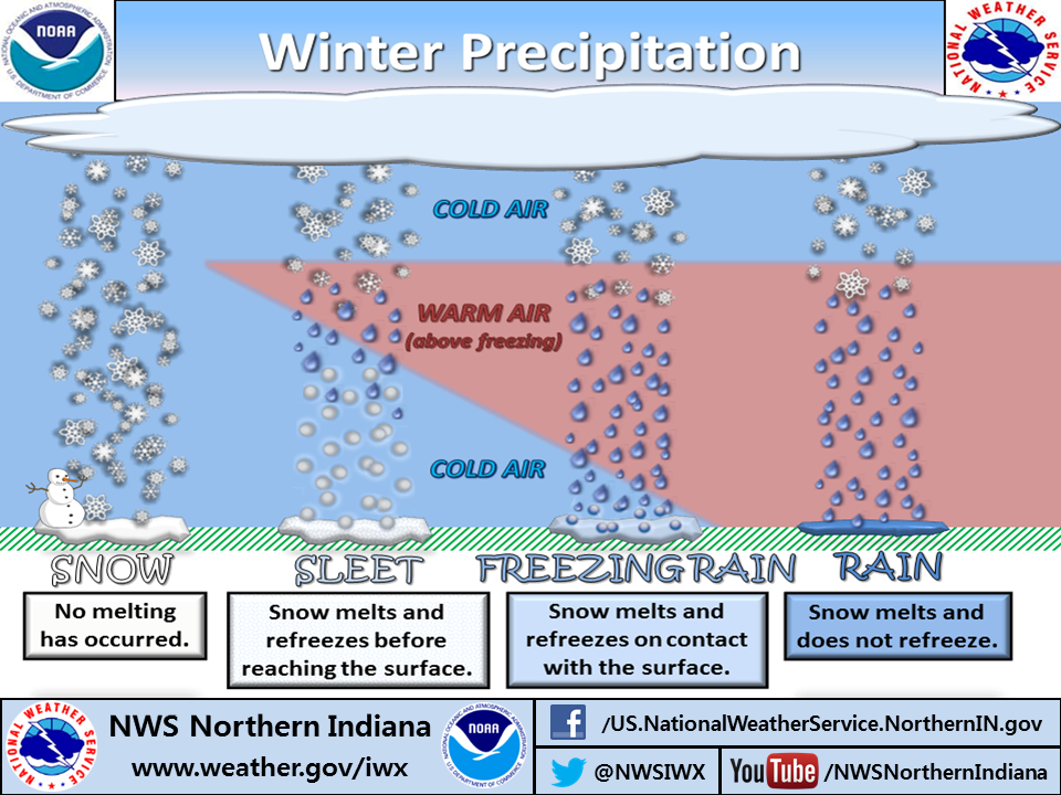
We're actually getting sleet at our house which wasn't on the numerical model forecasts above. Sleet is good compared to freezing rain which is really bad.
It suggests that we have a shallow pocket of warmer air aloft that is melting the snow but its refreezing ON THE WAY DOWN. Not on the ground, where it turns to a slick layer of ice(freezing rain).
https://www.weather.gov/iwx/sleetvsfreezingrain
Here's a zoomed in look at the vorticity max (500 mb level) at midnight from the just out 18z GFS operational model. As it approaches, that's when we should have the heaviest snow. It's a bit slower(getting here an hour or so later) than forecast on Sunday but should be to our east BEFORE 2am which will result in a fairly abrupt end to the accumulating snow.
I would be surprised if a feature this distinctive didn't cause an inch of snow.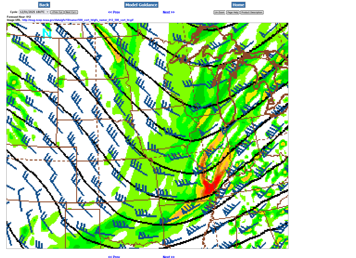
The green areas below show the back edge of the precip has passed EAST of Evansville at 2 am.
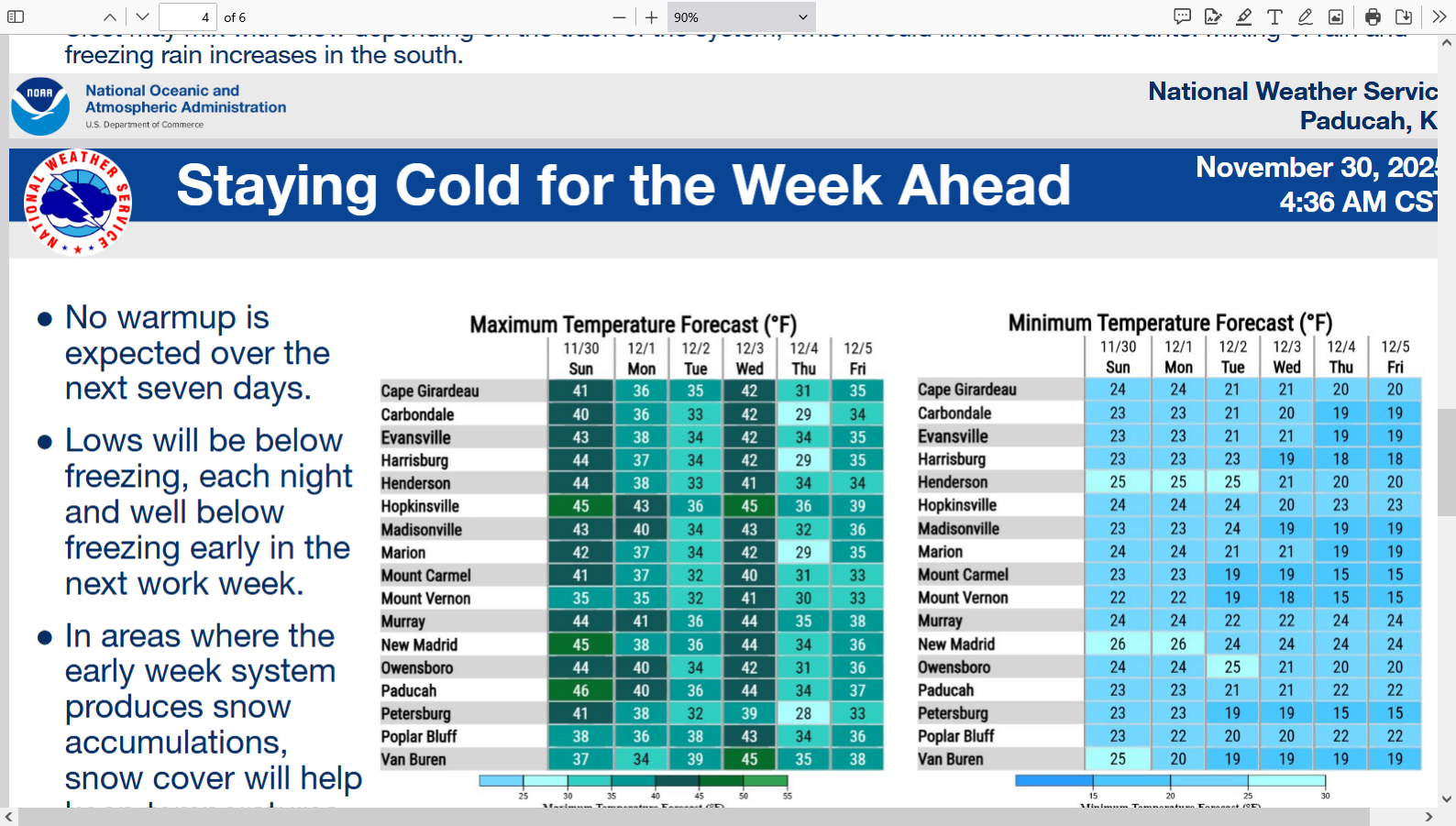
After that, light Northwest winds will bring in the coldest air of the season for Tuesday, even with sunshine. The sun should help roads to improve. but temperature will stay below freezing.
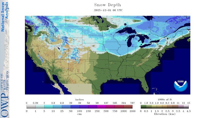
Here's the thing with the amount of cold coming in. Air masses coming from the Arctic or Canada at this time of year usually moderate as they track over bare ground in the northern half of the country.
Snow cover, some pretty deep, along with the very low sun able will reduce the amount of moderation happening as these cold air masses track over the snowy terrain going southward. The very minor amount of snow that we have on the ground tomorrow could also keep it a tad colder than if the ground was bare.
+++++++++++++
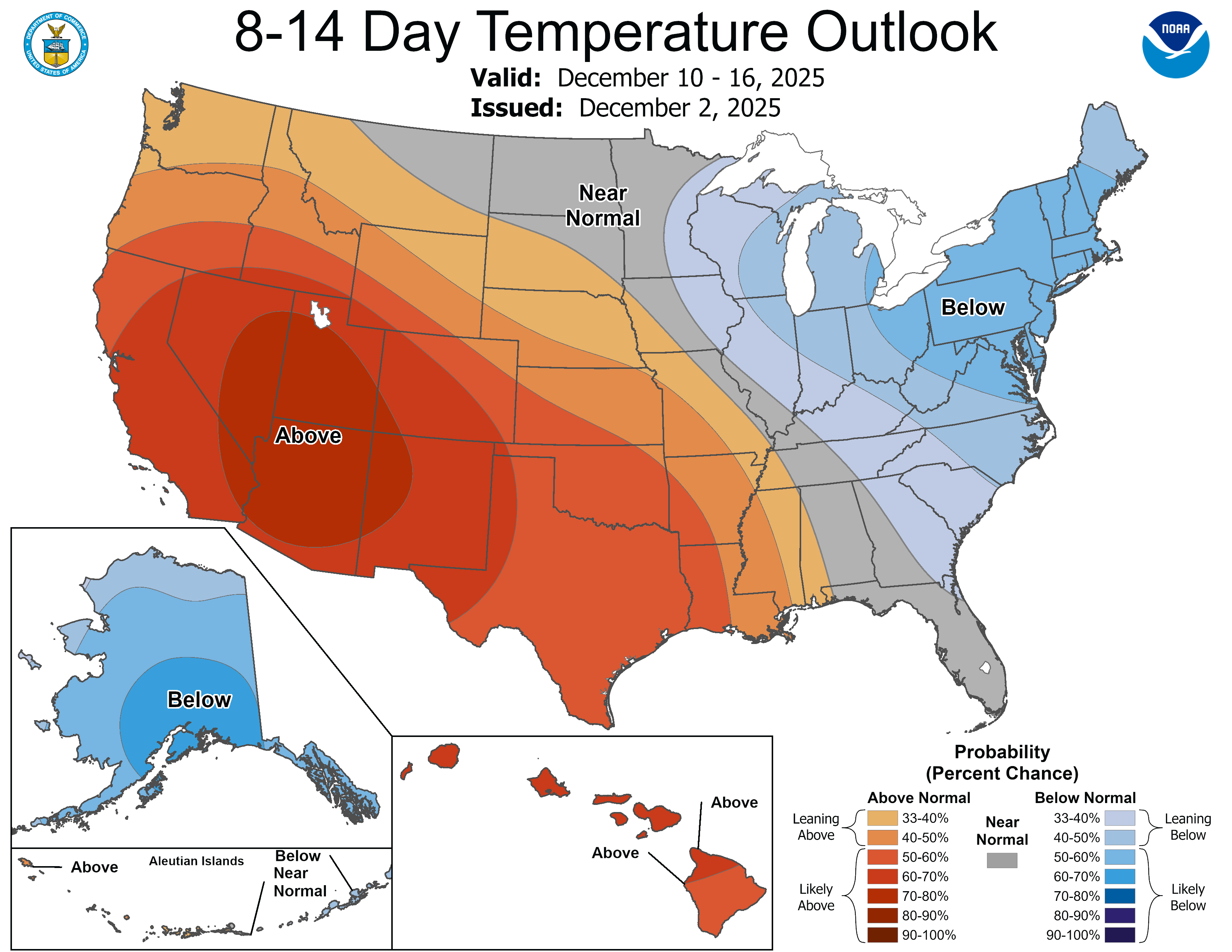
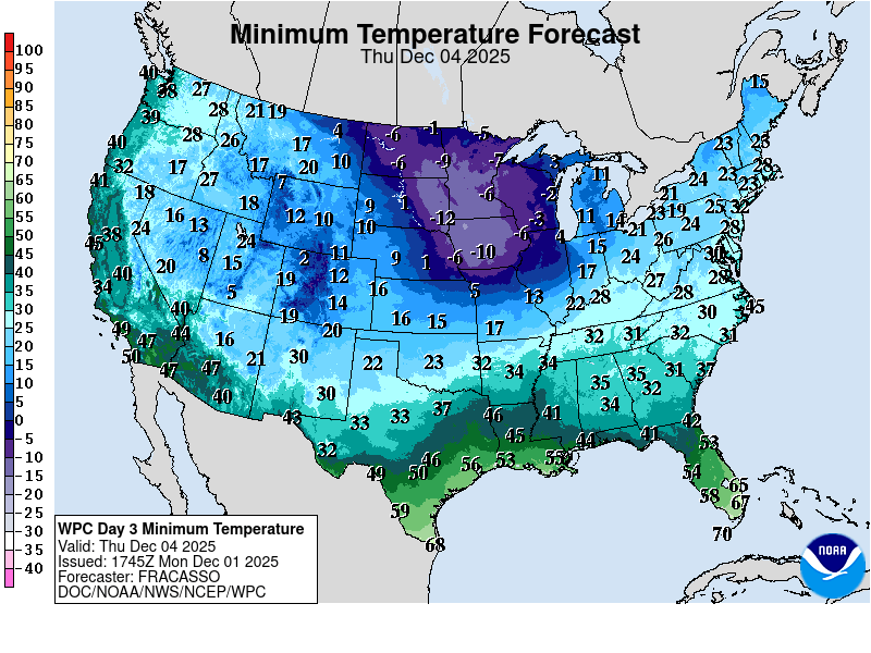
The coldest morning this week will be Thursday in the upper Midwest. Temps in the coldest places will be -10 Deg or even a bit colder!
https://www.nohrsc.noaa.gov/nsa/#snow_reports
Here at 10:25 pm, the front end of the window for snow is starting to close. We've got around 3 hours to get what we're going to get.
Local radar Super Resolution Base Reflectivity

There may be a dry slot north of the Ohio River that keeps amounts to less than an inch.
.9" from the latest numerical guidance below.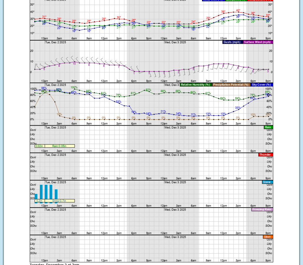
It's finally picked upQ. We should accumulate a bit for the next 60-90 minutes.
At least enough to cover the ground. Most of it may melt on the roads and we could have school on Tuesday.
The EVSC will be having a 2 hour delay for school on Tuesday. It’s currently just after 5am CST. The time stamps here are always in Eastern time.
https://district.evscschools.com/school_info/inclement_weath
I grew up in Detroit that averages 3+ times the amount of snow that Evansville gets.
In grades 1-12, guess how many snow days total we had?
it’s an easy to remember number…..0!
So it’s interesting to note all the fanfare over a forecast for an inch of snow.
Regardless, there's nothing more fun for me than to maximize the use of today's mind boggling technology, applying the physical principles of atmospheric science to analyze weather systems as they approach and share it here.
We really, really do live in the best age of human history when considering the opportunities to use this wonderful technology and the internet in positive ways. Especially to learn and be better informed, while applying objective, critical thinking.
It’s so easy to be drawn into negative elements and children, of course are most vulnerable. But we have unlimited choices and countless ones that are good choices.
It’s entirely up to us on how to incorporate this into our families lives.
I grew up 60 years ago with a love for weather. My Dad took me to the NWS when I was 10, in 5th grade for a private tour. What a wonderful memory.
I also utilized the latest technolgy to get the most updated weather information, starting when I was in 2nd grade.
I called the NWS to get their recorded weather message which was updated every hour with the latest hourly weather observations, along with the latest forecast.
i used my parents “party line” which all the neighbors on our block shared with each other. Of course we had 1 phone hooked up on the wall in our kitchen.
I would call 1 time, every single hour for much of the day on some days to get the updated hourly weather observations. I still remember the phone number!
W-E-A-T-H-E-R!
One of my jobs, starting in 2nd grade was to find out the weather for Mom so that she would know how to dress me and my 5 younger siblings in the morning as we grew up.
Nobody in the 1960s could have imagined today‘s internet and electronic devices.
Quadrillions of times more information at our fingertips, 24 hours a day. With that much information, there is boatloads to fill our heads with only good stuff……if we pick only good stuff!
Its awesome to have that choice in 2025!
People born into this age have no idea how lucky they are!
That's why we need old people like me sharing stories like this to appreciate it
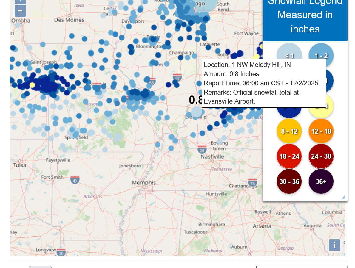
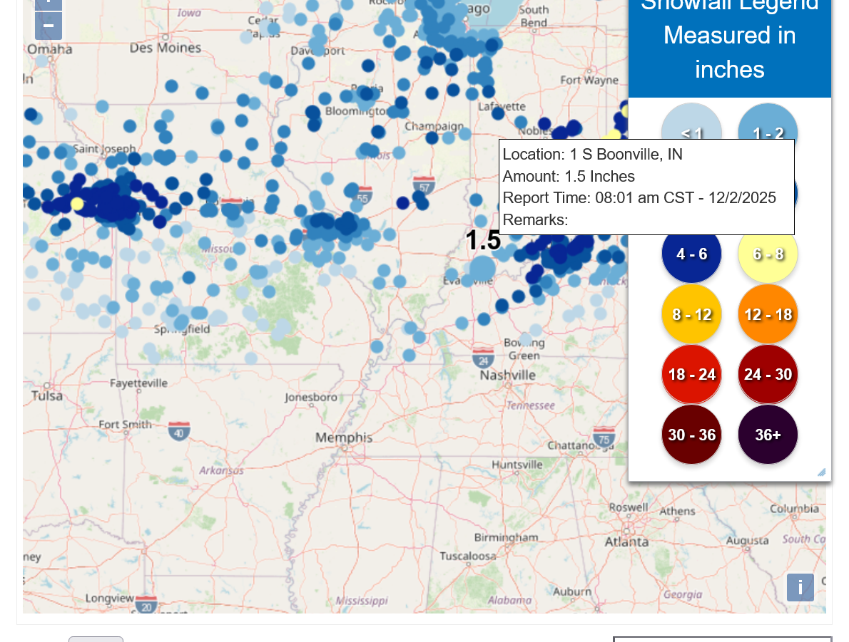
Snowfall Reports from the Last 24 Hours
https://www.weather.gov/source/crh/snowmap.html
At the NWS in Vanderburgh Country below:
From Posey County, just to our west below.

From Warrick County, the next county east of us.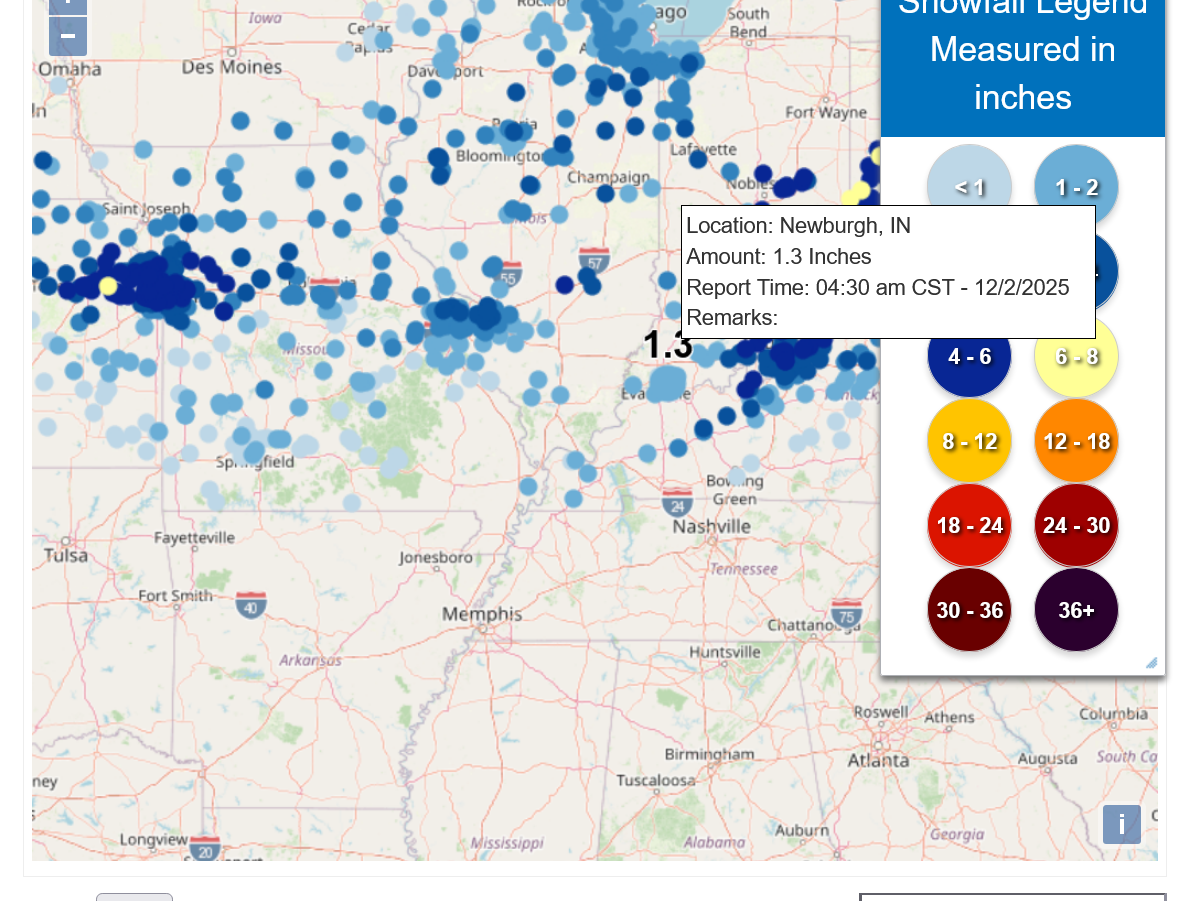
Henderson to our south:
Here's a great link to keep handy all Winter:
https://www.weather.gov/pah/winter
++++++++++++=
For regulars here, especially new people not in any of our chess clubs in Evansville wondering what's up with the thread focusing mainly on Evansville weather.
As chess coach at several local schools, I provide these MarketForum weather thread links to our chess families and the teachers at their schools and others during the chess season (my email list total can sometimes get close to 1,000 people).
Big weather events in other places of the country are still covered(like those threads below) but for the next 5+ months or so, like prior years there will be some that focus on the impact on Evansville, IN.
Previous Winter weather thread:
11-21-25 Much colder pattern coming up!
Started by metmike - Nov. 21, 2025, 3:17 p.m.
https://www.marketforum.com/forum/topic/116112/
++++++++++
You can get all the constantly updated, comprehensive weather here:
Weather-UPDATED LINKS
97 responses |
Started by metmike - April 30, 2022, 8:01 p.m.
https://www.marketforum.com/forum/topic/83844/
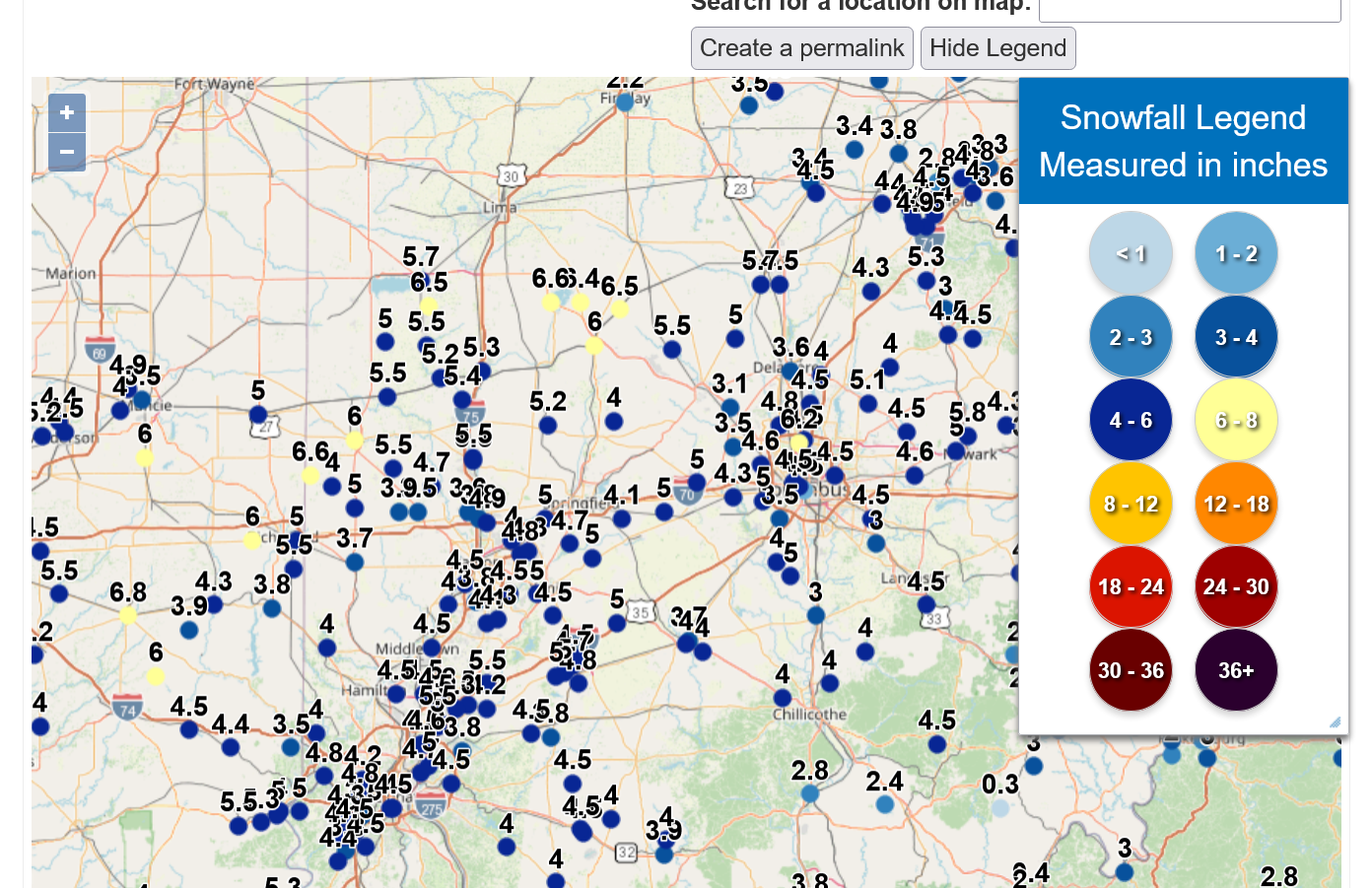
The snowfall report page was updated:
The Paducah NWS updated their snowfall reports. Looks like Evansville got less than most places!
Public Information Statement National Weather Service Paducah KY 336 PM CST Tue Dec 2 2025
...DECEMBER 1-2, 2025, SNOWFALL REPORTS
https://partnerservices.nws.noaa.gov/products/cache/336-2025/PNSPAH/18fb7e926e2ea5793532a511c1216046
We (WC oh) ended up with more than i was expecting. Around 6" which matches pretty close the weather.gov link you posted where it showed 5.5".
Wasn't super cold or windy which was great but it still took about 2 hours with skid steer to get the barnyard cleaned up.
Thanks buck!
I see exactly what you're saying about that area in the great state of Ohio, where this storm organized/strengthened more as it tracked east. It's excellent that you brought this up.
https://www.weather.gov/source/crh/snowmap.html
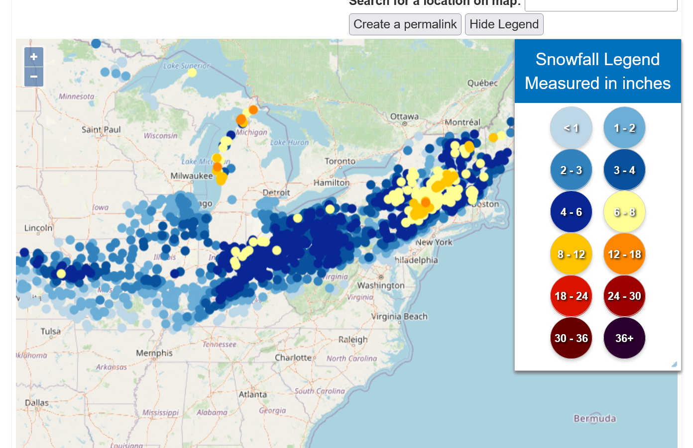
That's highway 70 cutting west to east across the center of the map, from Indiana to Columbus OH
Adding to the extra chill is an unusually extensive snowpack for early December. This is keeps it cool in several ways.
1. Snow pack reflects shortwave radiation from the sun back to space.
2. Snow pack radiates longwave radiation from the surface better than bare ground which results in colder nights too.
3. It take alot of heat energy to melt snow.
4. Frigid Arctic air masses moderate quicker over bare ground. Less so over snow pack.
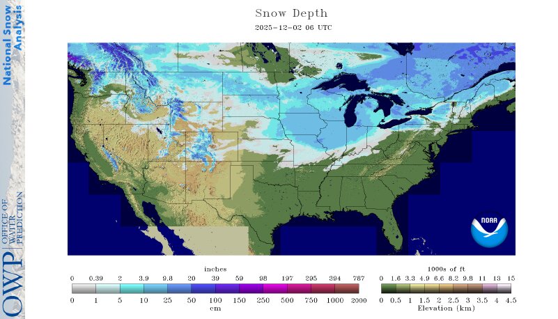
https://www.nohrsc.noaa.gov/nsa/
This map below doesn't have todays snow in the East.
Daily Snow Extent - December 2, 2025 (Day 336)
https://climate.rutgers.edu/snowcover/chart_daily.php?ui_year=2025&ui_day=336&ui_set=0
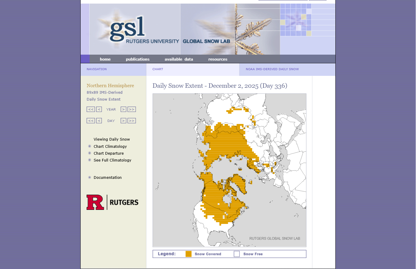
The blue is a positive snow anomaly below for this date. That is ADDING a positive reinforcing element to the below average temperatures in this same are as described above.
This is a map for the entire Northern Hemisphere. That's a pretty large area that normally doesn't have snow or doesn't have this much snow in early December.
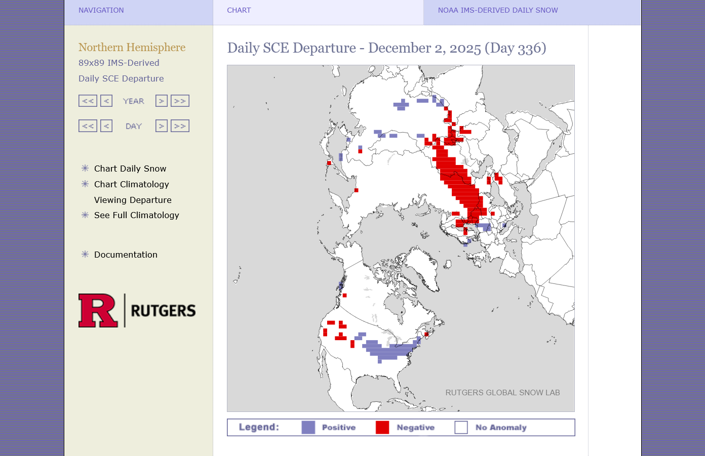
The current forecast, thru week 2 is not favorable for melting much of this snow. In fact, we are dumping more in the Northeast right now and tomorrows snow anomaly will be greater in the Northeast:
https://www.marketforum.com/forum/topic/83844/#83852