Previous threads:
The big thaw! 2-2-26
17 responses |
Started by metmike - Feb. 2, 2026, 1:48 p.m.
https://www.marketforum.com/forum/topic/117703/
++++++++++++++
1-23-26+ Tracking the historic Winter Storm
22 responses |
Started by metmike - Jan. 24, 2026, 12:17 a.m.
https://www.marketforum.com/forum/topic/117428/
+++++++++++++++++
Historic snow/ice, late week of 1/18/26
26 responses |
Started by metmike - Jan. 18, 2026, 4:49 p.m.
https://www.marketforum.com/forum/topic/117294/
++++++++++++++
Frigid Blast
Started by metmike - Jan. 17, 2026, 10:44 p.m.
https://www.marketforum.com/forum/topic/117282/
++++++++++++++
Get all the comprehensive weather here:
The strong Pacific origin jet stream will play a key role in our weather this week. This is the look at the jet stream in the Pacific.
The upper level low is just off the Pacific Northwest coast.
Currently, we see a phasing of the Polar(northern) jet stream and a farther south subtropical jet.
Ahead of that, the Midwest will see southwest steering currents and strong south winds at the surface.

Shifting the map much farther east and time frame to late Thursday, we see the MAINg jet stream aimed in this direction. The red shade is 150 knots which is almost 175 mph.
Plenty strong enough to generate the lift and spin/rotation for severe storms and some tornadoes that will be possible late Thursday.
https://mag.ncep.noaa.gov/Image.php

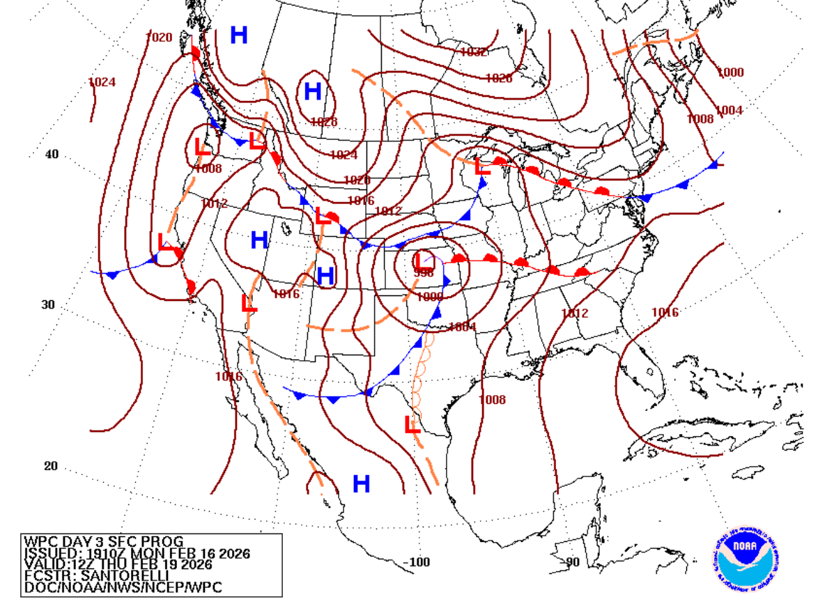
This is the surface map below early on Thursday. A surface low pressure system is developing/deepening in KS with warm, humid unstable air gushing north ahead of it and cold Arctic air dropping south from Canada with a robust High north of Montana.
In addition, we can see a Pacific cold front in Texas, with a dry line trough behind it.
https://www.wpc.ncep.noaa.gov/medr/nav_conus_pmsl.php?fday=3&fcolor=wbg
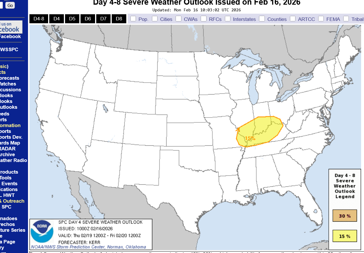
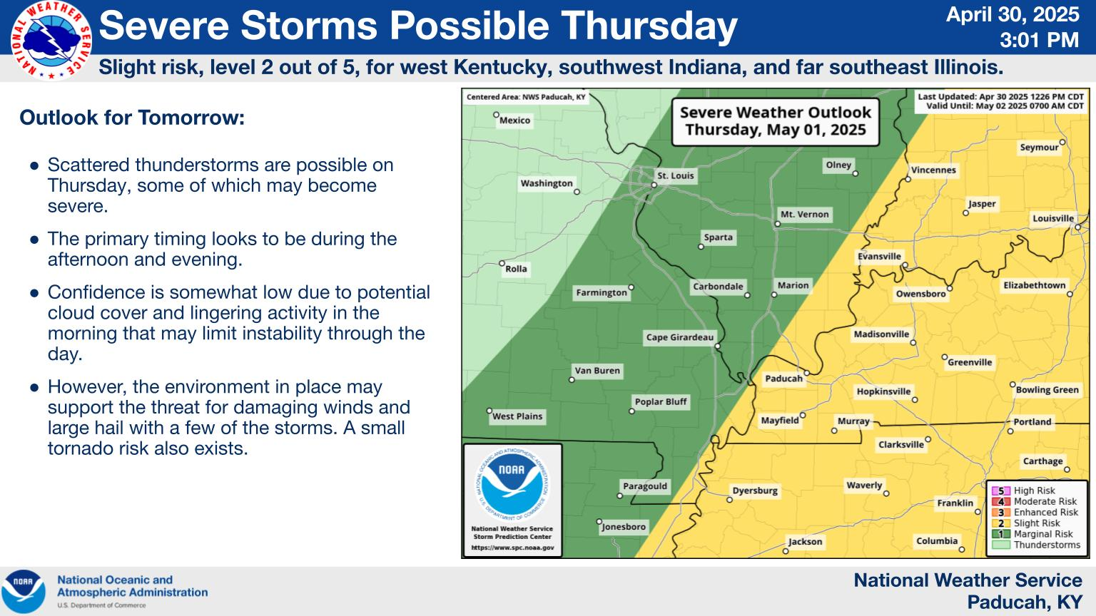
The Storm Prediction Center issues general severe weather risk areas up to 8 days ahead of the events. We are currently in an area that has some risk. As we get closer, the will refine the risk. It should be AT LEAST a slight, level 2 risk, with potential for an enhanced level 3 risk. It's not completely impossible to have it elevated to moderate, level 4 risk.
https://www.spc.noaa.gov/products/exper/day4-8/#
See the explanations below:
https://www.weather.gov/media/ewx/iwt/SPC_WPC_Differences.pdf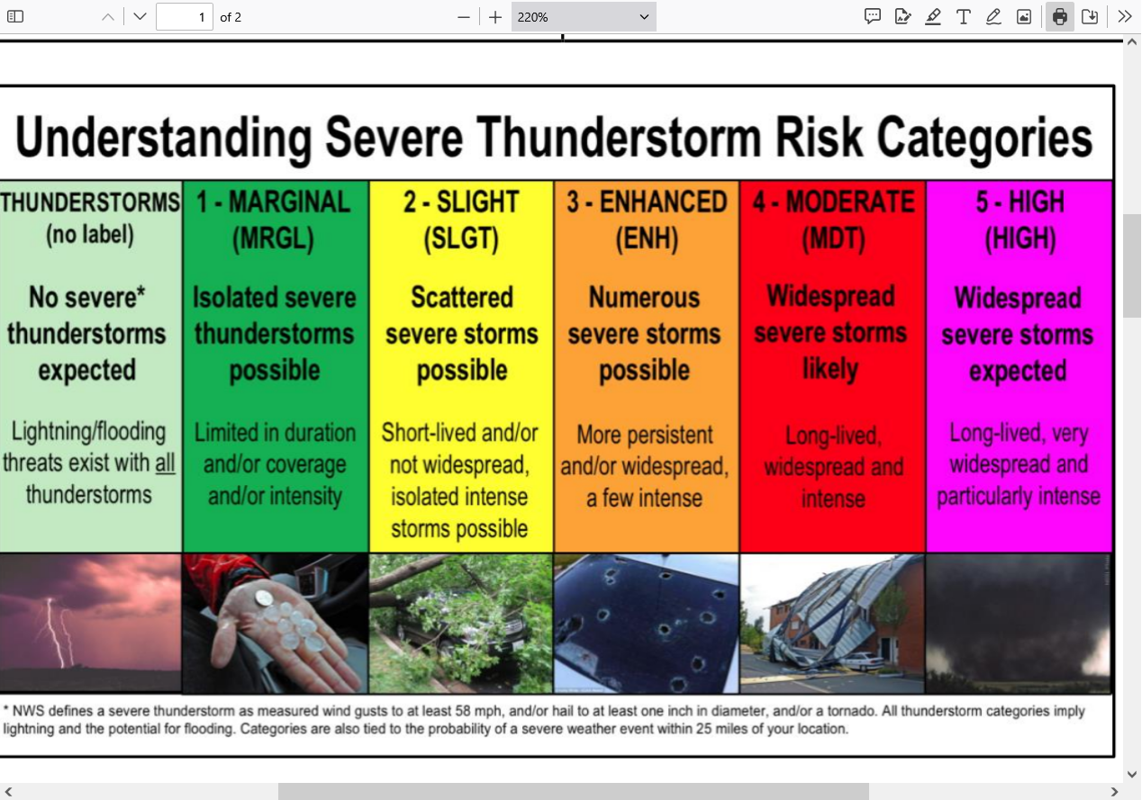
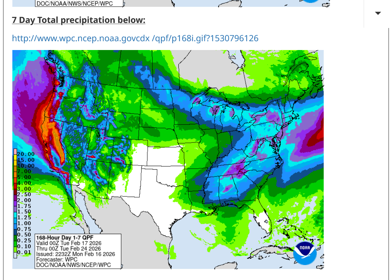
The good news is that many areas will see welcome rains and in the mountains, welcome snows that will melt late in the year and provide wonderful water to communities downstream of the melt water.
https://www.marketforum.com/forum/topic/83844/#83848
https://www.wpc.ncep.noaa.gov/qpf/p168i.gif?1530796126

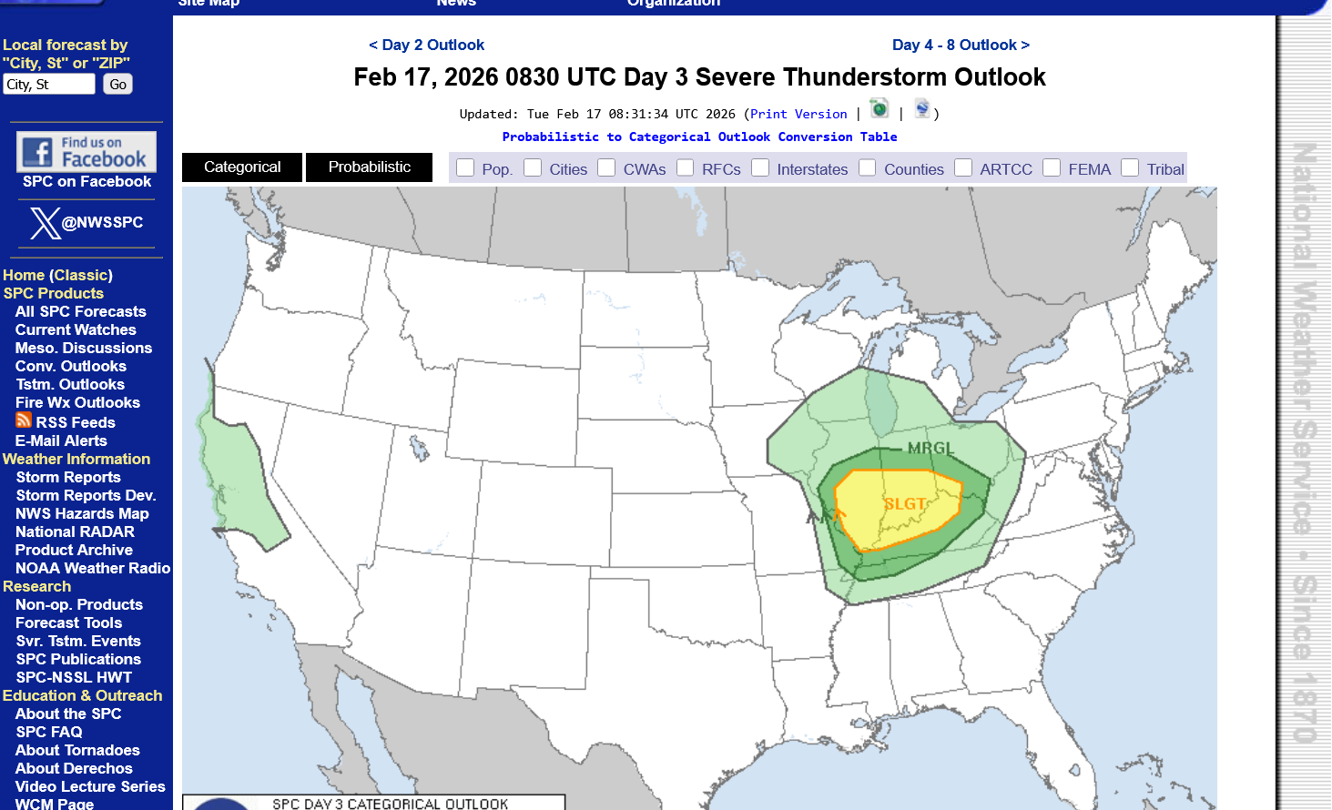
Tuesday's update from the Storm Prediction Center:
https://www.spc.noaa.gov/products/outlook/day3otlk.html
This is not likely to be a major outbreak of violent tornadoes. However, there is likely to be SOME severe weather that includes a few tornadoes and potentially a strong tornado. With that being the case, the smart thing to do is to monitor it, especially as the cold front triggering storms approaches on Thursday.
When a watch is issued, if it's a TORNADO watch. Stay very tuned into the weather as the storms get close. If there aren't many reports of severe weather as it approaches or none of them are tornadoes, the need to go to a safe place is low. Severe storms will not hurt you inside a permanent building with a foundation. Even weak tornadoes won't hurt you but stay away from windows.
However, STRONG tornadoes, which tend to be long lived and easily tracked and well warned for are the ones that justify going to the safest place in your home(lowest level/basement and center of the house).
The Storm Prediction Center will usually have this verbiage in their statements when the dynamics are favorable for strong to violent tornadoes: "This is a particularly dangerous situation"
If you see that verbiage, it's time to forget "The boy who cried wolf" mentality of the past XX times of storms coming thru and nothing happened to you, which will probably be this time too.
That verbiage justifies staying up to see if a strong tornado is headed for your county/neighborhood overnight. If you have a weather radio is will wake you up for that.
Not having that more alarming verbiage doesn't mean a strong tornado can't happen but the chances are greatly reduced. WEAK tornadoes, yes but 150+ mph tornadoes that kill the most people, not so much.
Most tornadoes are WEAK tornadoes fortunately. This is event is still 2+ days away but the dynamics at this point favor weak tornadoes, although some guidance is more elevated.
I would not be surprised if they increase the risk to a level 3 of 5 "enhanced" with tomorrows update as the event gets closer. I would be extremely surprised if this system approaching ever results in a level 5 of 5 "high" risk and probably not even 4 of 5 "moderate" risk. Those are the levels which result in that "this is a particularly dangerous situation" verbiage.
The type of tornado possible late Thursday would most likely fall into the EFO and EF1 category below. An EF2 is also possible. Higher categories can't be ruled out completely but the dynamics are UNfavorable for the strongest tornadoes that kill the most people.
Be prepared late Thursday but know that this is not likely to be a particularly dangerous situation.
Enhanced Fuita scale
https://en.wikipedia.org/wiki/Enhanced_Fujita_scale
| EFU | Unknown | No surveyable damage |
|---|---|---|
| EF0 | 65–85 mph | Light damage |
| EF1 | 86–110 mph | Moderate damage |
| EF2 | 111–135 mph | Considerable damage |
| EF3 | 136–165 mph | Severe damage |
| EF4 | 166–200 mph | Devastating damage |
| EF5 | >200 mph | Incredible damage |
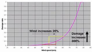
Here's the deal on wind and damage.
As wind increases the damage massively increases on an exponential scale. This applies to ALL wind.
Severe storms and hurricanes and especially tornadoes that have the strongest winds of all, which means the tornadoes with winds over 150 mph have incredible damage.
+++++++++++
+++++++++++++++++++++
A 150 mph wind does 256X more damage than a 75 mph wind. Let's repeat that. A 150 mph wind does 256x more damage than a 75 mph wind!
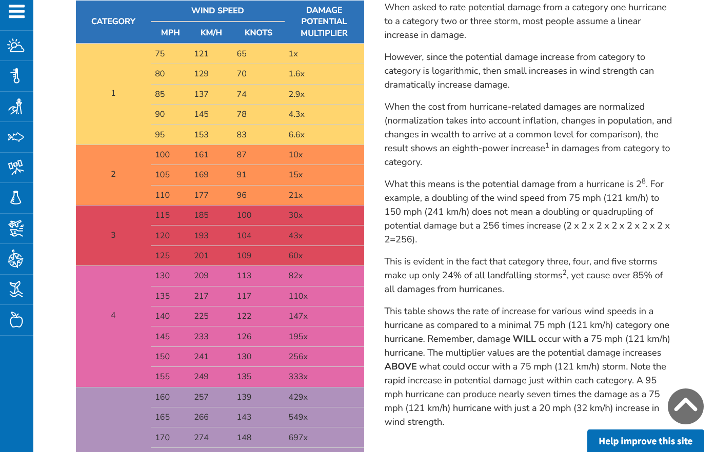
Hurricane Damage Potential
https://www.noaa.gov/jetstream/tc-potential
++++++++++++
Less than 1% of tornadoes are F4 or F5 but they kill 67% of the people!
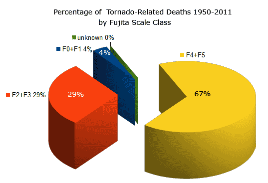
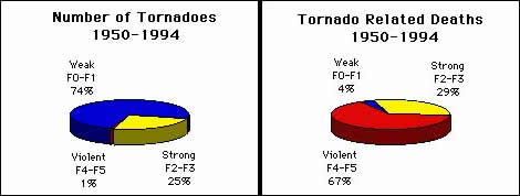
Note that the majority of tornadoes, F0 and F1= 74%(on the old scale) only killed 4% of people and they were probably outside or in a mobile home.
The F4 and F5's were just 1% but caused 67% of deaths.
+++++++++++++++++++
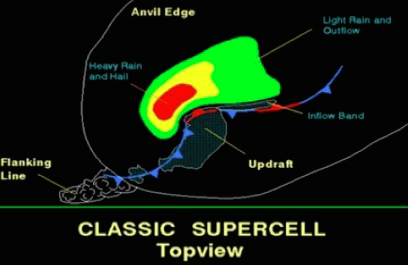
https://www.weather.gov/ama/supercell
++++++++++++
Excellent presentation at this link below that describes the different types of tornadoes and the damage they cause. Keep in mind that the EF4 and EF5 tornadoes are extremely rare. Less than 1% of tornadoes are this strong. Today is one of those rare days.
The EF4 and EF5 tornadoes will usually have the HIGH, level 5 risk earlier that day.
Mike Simon Tornado Damage Intensity; Enhanced Fujita Scale
Very deep low right now in the Northern Plains.
https://www.spc.noaa.gov/exper/mesoanalysis/new/viewsector.php?sector=19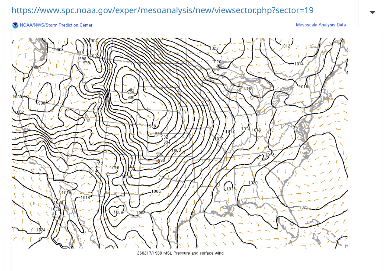
No severe weather because the deep moisture has not returned. The 70's are bone dry, desert type air.
https://www.marketforum.com/forum/topic/83844/#83845
As severe weather outbreak's get closer, we can see things coming together better and with more updated data which gives us confidence and almost always results in the Severe Storm Forecast Center INCREASING their risk categories, with increasingly serious verbiage. One of the phrases that I mentioned yesterday "this is a particularly dangerous situation" will be included.
I mention that above to distinguish the CURRENT situation from a typical, approaching severe weather outbreak.
In other words, the current situation, at this point STILL does not look that bad and we are just over 24 hours away!
https://www.spc.noaa.gov/products/outlook/day2otlk.html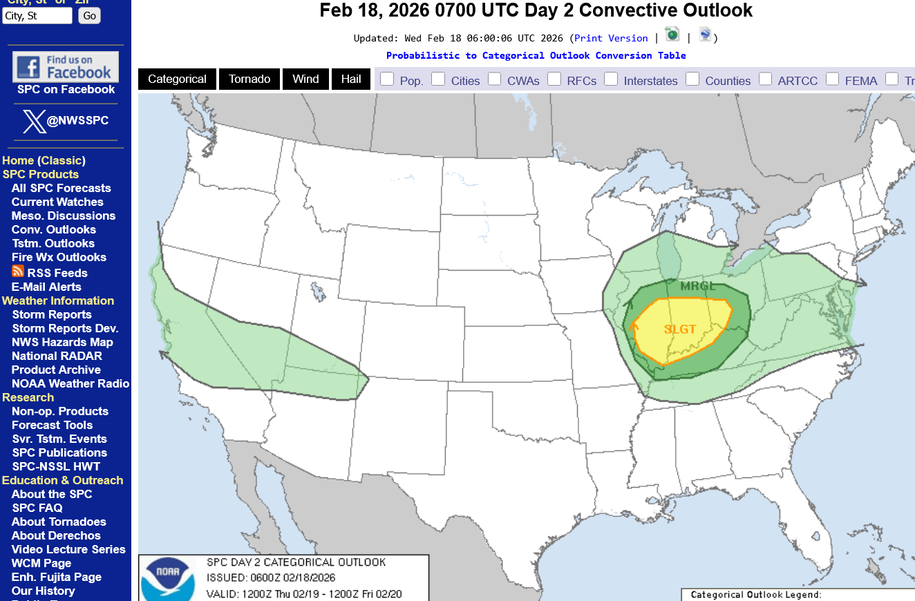
However, we should still, CLOSELY monitor and be ready to go to a safe place late Thursday because there is still a slight risk and that risk includes tornadoes(probably weak tornadoes but not for sure).
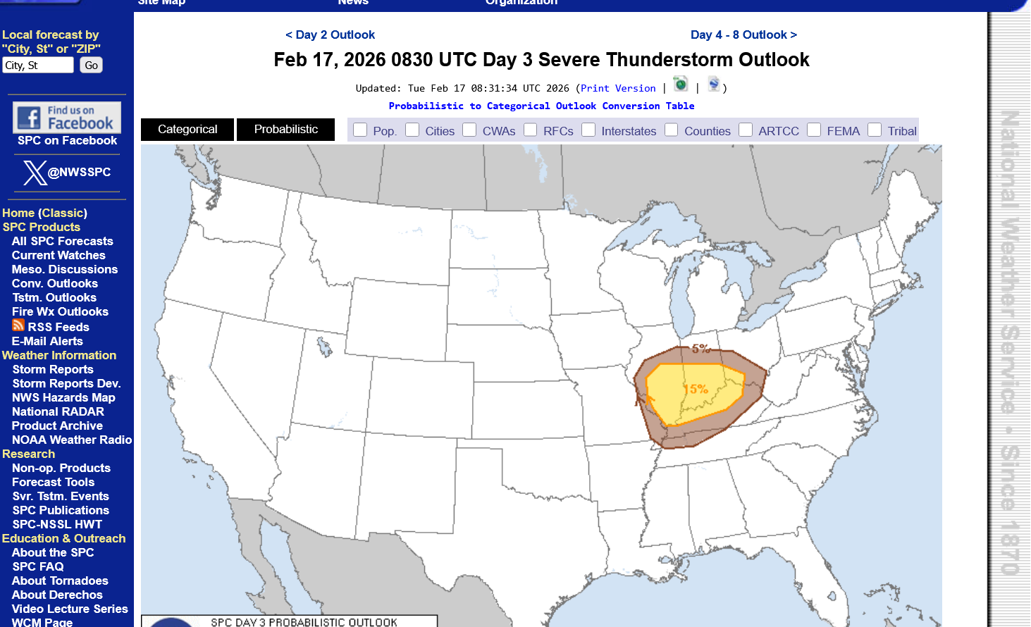
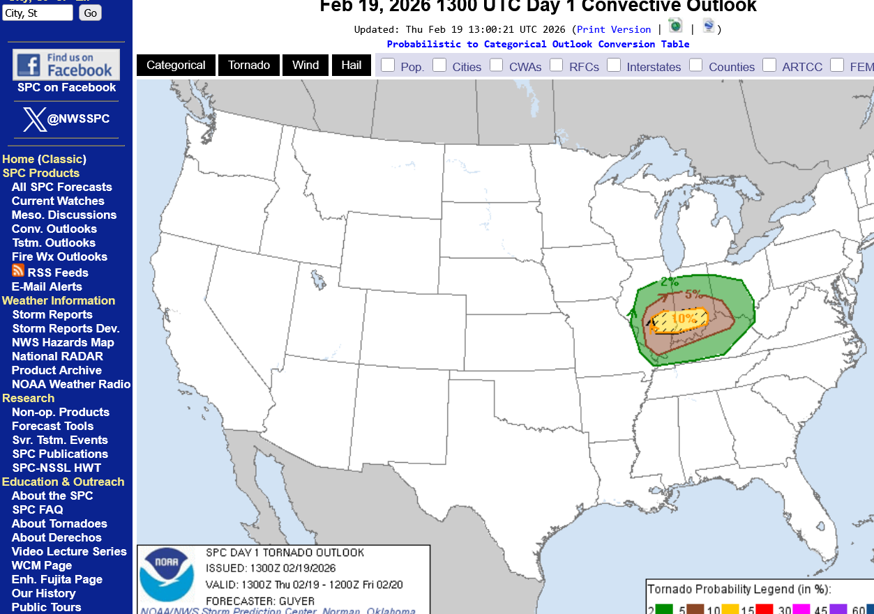
Chance of a tornado within 25 miles of any point below = 5%(probably a weak tornado in this case but not for sure)
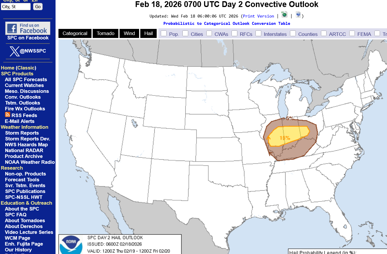
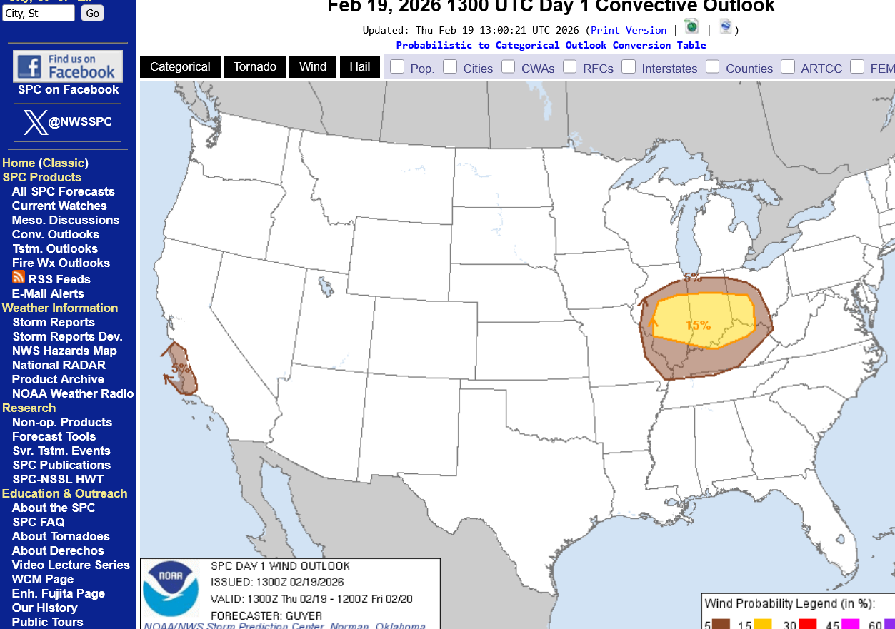
Risk of severe thunderstorm winds greater than 58 mph within 25 miles below =15%. This is the main threat late Thursday. Staying inside and away from windows is always a good idea in all thunderstorms.
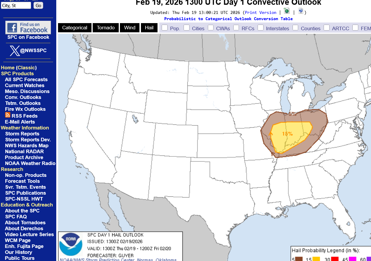
Risk for hail below: just under 15%.
Is sleeping in bed during a severe thunderstorm warning a safe place?
Yes!
Even though a severe thunderstorm CAN produce a tornado, the NWS issuing a SEVERE THUNDERSTORM warning and NOT a TORNADO warning tells us that all their technological tools/radar tell them a tornado is unlikely.
You are safe inside a permanent structure(not a mobile home) away from windows during a severe thunderstorm warning, as long as your bed is not next to a big window.
Tornado warnings are a different deal and should be taken more seriously!
Even then, the vast, VAST majority of tornado warnings are for tornado signatures on the radar that never touch down and for weak tornadoes on the ground. We would be safe sleeping in our bedrooms for those type of events.
However, when strong and especially violent tornadoes hit, being in the right place during a direct hit can mean the difference between life and death.
Chances of that type of tornado on Thursday looks extremely low!
Otherwise, the Storm Prediction Center would have at least an enhanced, level 3 risk and more likely a moderate, level 4 risk.
Stay tuned though. This is weather and it can change. However, what I have NEVER seen is for a slight risk 24 hours away turning into a HIGH risk the next day 3 categories up.
We know MOST of what there is to know on assessing risk right now. A predicted 150 mph on Wednesday, isn't going to turn into a 200+ mph jet stream on Thursday that increases the chances for violent tornadoes.
The next phase will be the actual event. Tracking the storms and warning for the severe ones, that includes tornado warnings in some cases.
Additional thoughts/advice:
It's never a good idea to be outside during any thunderstorm because lighting kills more people than tornadoes in most years and EVERY thunderstorm, by definition has lightning.
However, sometimes this is impossible to avoid.
The good news tomorrow is that these thunderstorms will not have a great deal of lightning and will lack the especially dangerous cloud to ground lightning because the air mass will not be very warm/humid.
It's the very warm/humid, UNSTABLE air(typical of the warmer seasons) rising rapidly that generates the huge electrical charge differential between locations (the clouds/ground for instance) which results in a lightning strike between those locations to neutralize the charge that built up.
+++++++++==
https://www.heritagepci.com/blog/lightning-strikes-are-highest-in-july-and-august/
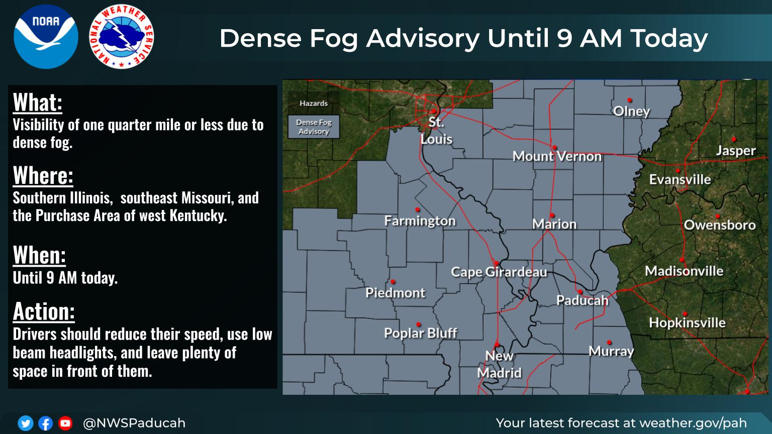
Current Hazards at the link below.
For your NWS and county, go to the link below.
Then you can hit any spot on the map, including where you live and it will go to that NWS with all the comprehensive local weather information for that/your county.
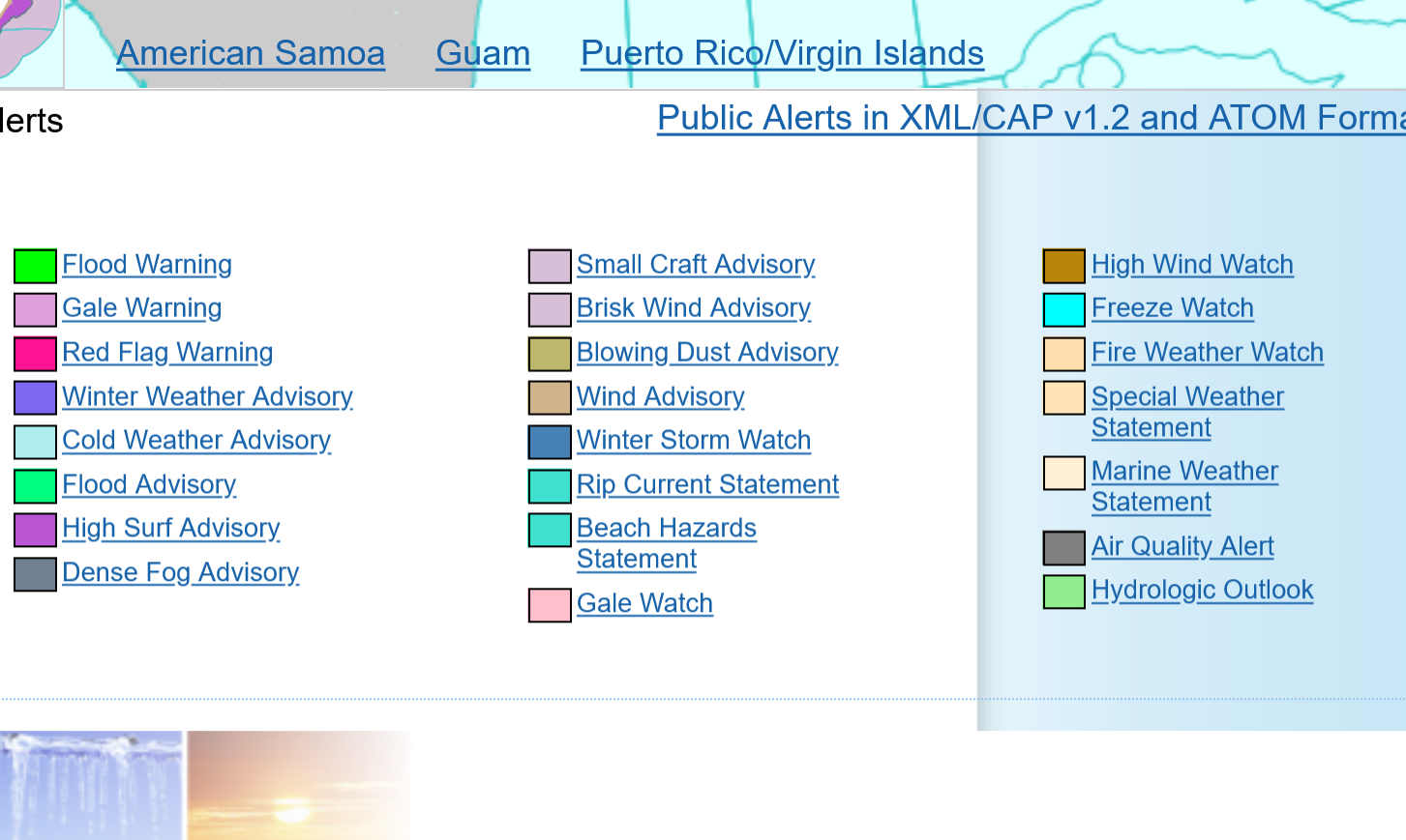
Here's what the colors on the map above stand for:
Why so much pink in the middle of the country(red flag warnings)?
Soilmoisture anomaly:
These maps sometimes take a day to catch up to incorporate the latest data(the bottom map is only updated once a week).
https://www.cpc.ncep.noaa.gov/products/Soilmst_Monitoring/US/Soilmst/Soilmst.shtml#
![]()

++++++++++++++++++++++++++++
Updated daily below:
https://mrcc.purdue.edu/cliwatch/watch.htm#curMonths
Support for all MRCC-hosted products and services is currently suspended as of April 17, 2025, due to a lapse in federal funding from the Department of Commerce through NOAA.

NEW LINK:
https://www.drought.gov/current-conditions
Thru February 10, 2026
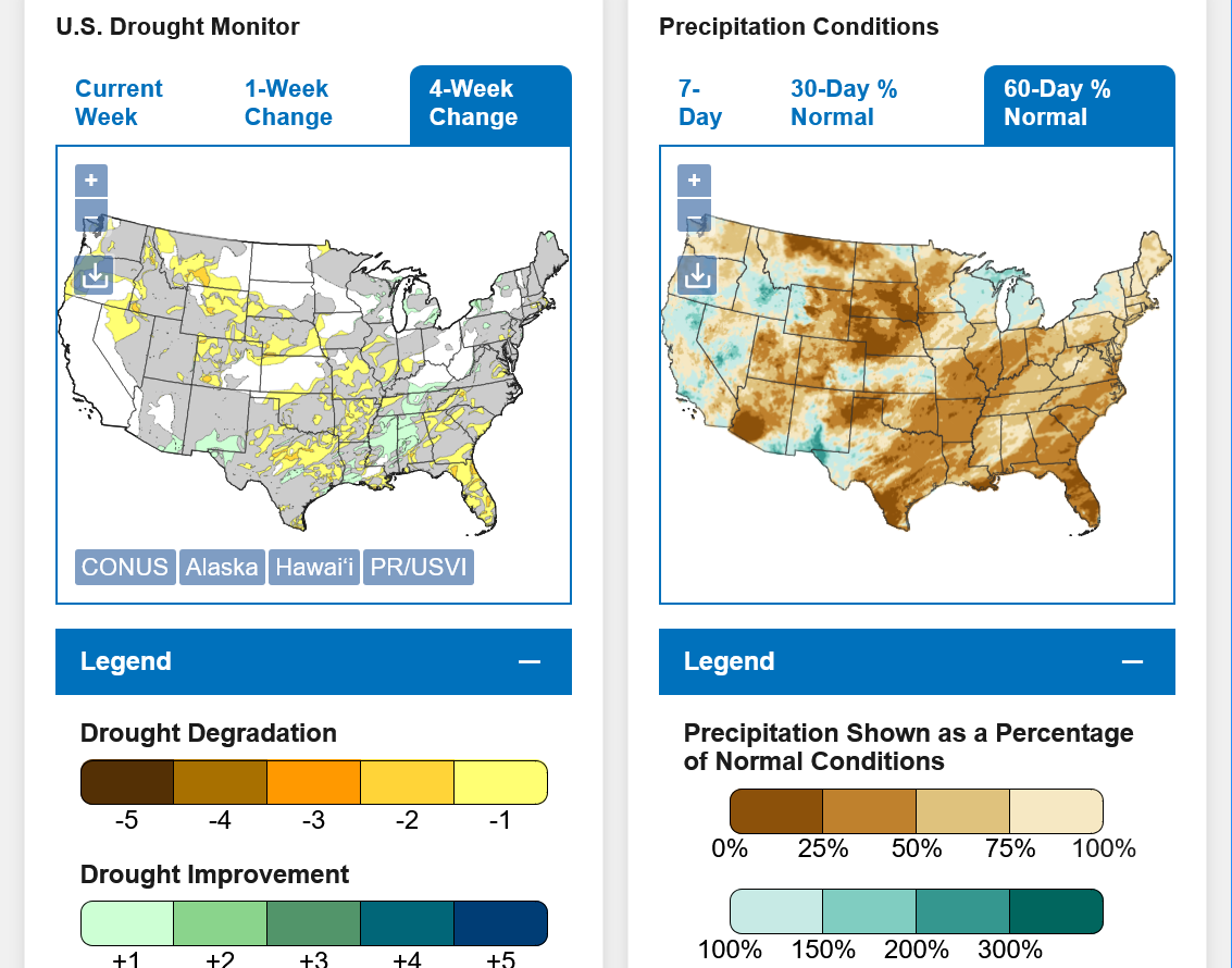
DROUGHT MONITOR
https://droughtmonitor.unl.edu/
Drought expanded this Winter from Southern Plains, northeastward.
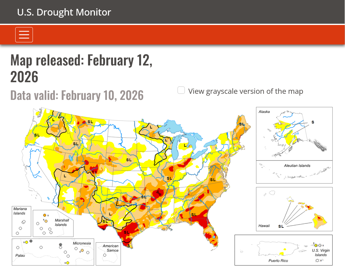
We could use some rain to replenish soil moisture in many areas right now even though the growing season is still 2 months away. The rapidly developing El Nino will increase the chances of that!
2-17-26 El Nino, here we come-FAST!
Started by metmike - Feb. 17, 2026, 11:54 a.m.
https://www.marketforum.com/forum/topic/117969/
This is usually good news for crop production but not all El Nino's are the same.
Like with all storms, we'll have a decent jet stream aloft at 30,000+ feet above the ground. This is the forecast late Thursday.
https://mag.ncep.noaa.gov/Image.php
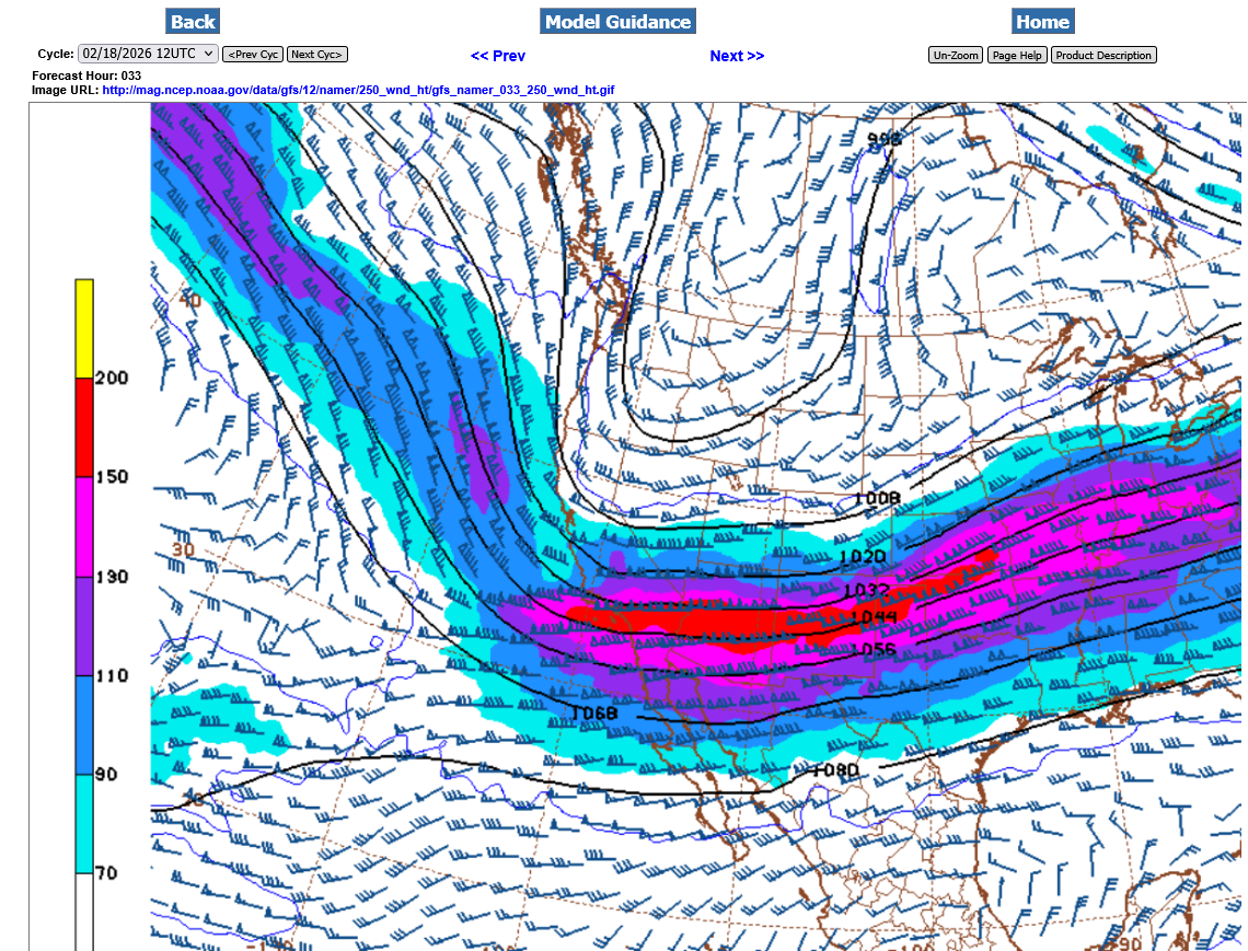
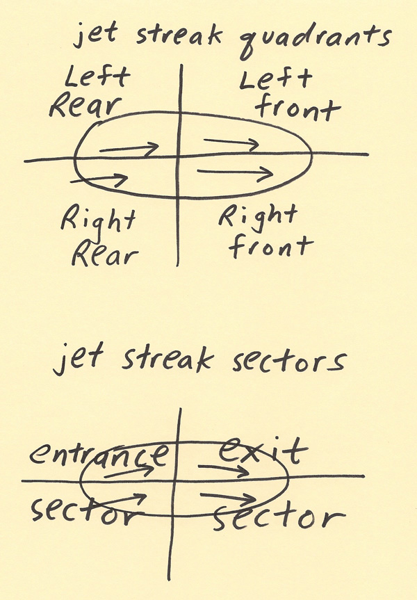
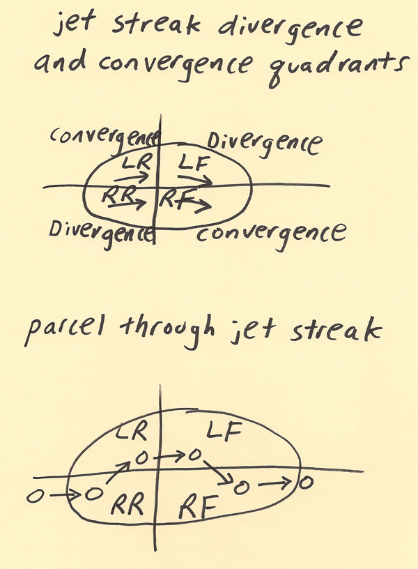
Strong jet streams like this cause tremendous divergence aloft which sucks the air up from below like a vacuum cleaner, adding to lift/instability. The jet stream will be increasing as the day goes on Thursday.
Our position with respect to the jet streak of highest winds is on the right/front quadrant side. This results in a bit more convergence aloft which reduces lift and instability.
Compared to the LEFT front quadrant that ADDS additional divergence aloft and maximizes the lift.
This means that the highest risk, that includes tornadoes will be NORTHWEST of the Ohio River and Evansville, in In/IL with a lower risk in KY.
https://www.theweatherprediction.com/habyhints2/601/
| HABY'S WEATHER FORECASTING HINTS |

As indicated from the previous post yesterday evening, the highest risk for severe storms, especially tornadoes will be NORTH of the Ohio River. Now that the event is extremely close, the Storm Prediction Center today feels confident enough to add an enhanced, level 3 out of 5 risk north of the Ohio River to their assessment.
This is especially with regards to TORNADOES. They have just added the potential of EF2 tornadoes which are strong tornadoes. This means we need to take this threat more serious than just a threat of EF0 and EF1 tornadoes.
This is NOT a particularly dangerous situation, however EF2+ tornadoes can kill people, more on the next page.
https://www.spc.noaa.gov/products/outlook/day1otlk.html

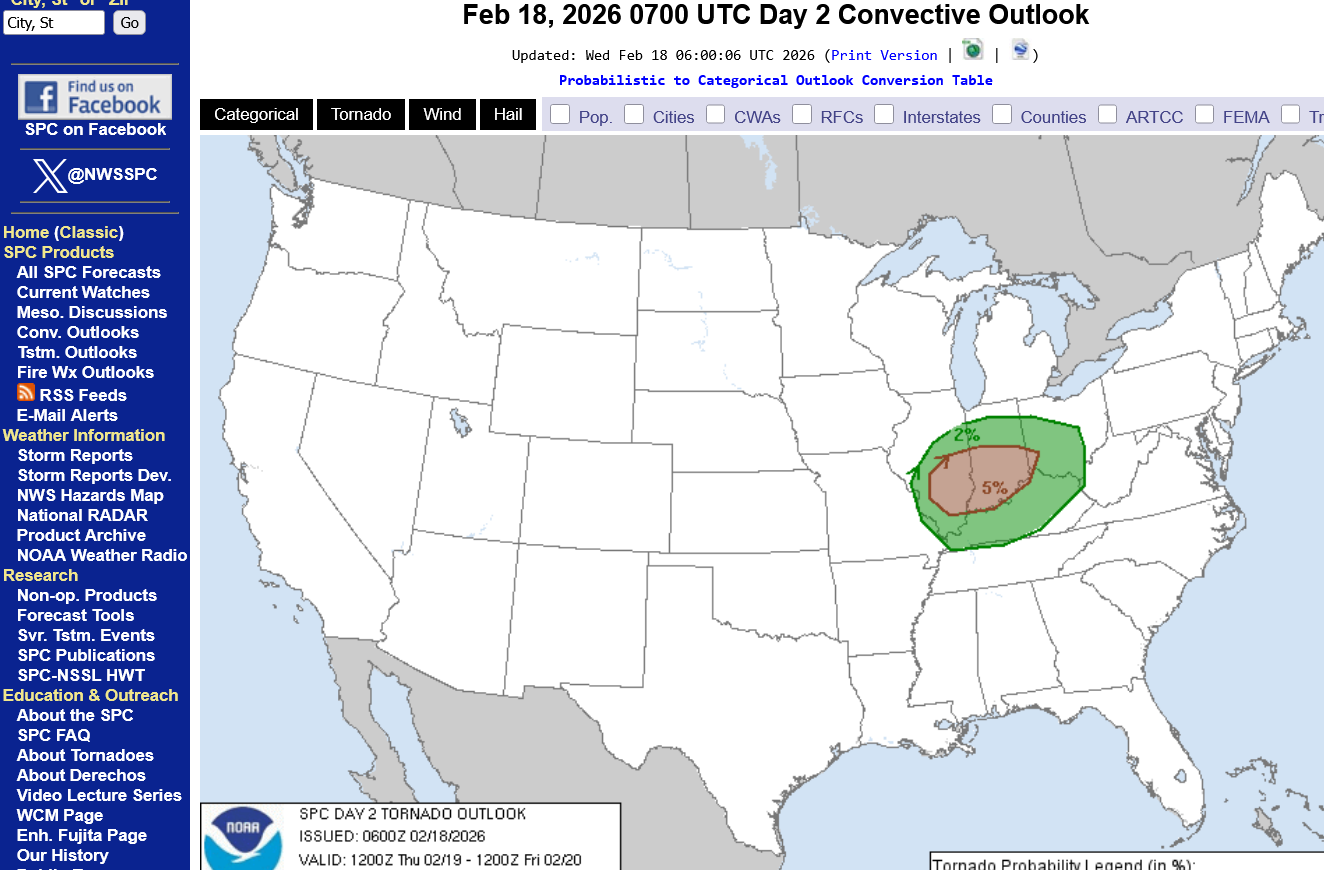
Risk of tornadoes below. The hatched area outlines the zone that is SIGNIFICANT. It's close enough to Evansville for us to treat this risk as a serious one because we can't pinpoint where the worst storms will be with enough accuracy to say that zone won't be 50 miles farther south, which is Evansville. There could be EF2+ tornadoes.
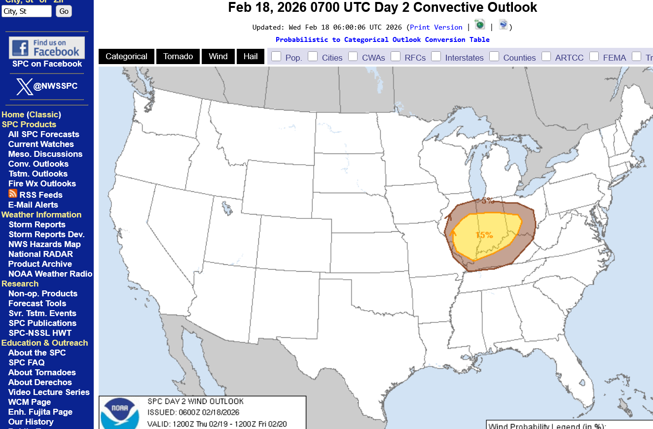
Risk of damaging winds below.
Risk of large hail below
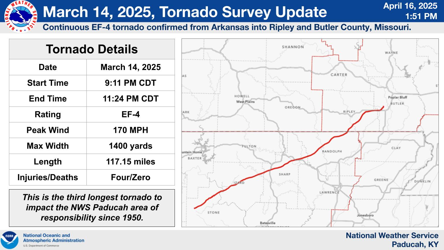
Previous discussion on tornado strength:
Re: Re: Re: Re: 2-16-26 active weather week!
By metmike - Feb. 17, 2026, 1 p.m.
+++++++++++++++++
Lets add to that here:
TORNADO PUBLIC SAFETY
https://www.theweatherprediction.com/wxsafety/tornado/
++++++++++++
The storm prediction center has elevated the risk to include EF2 type tornadoes today. The average person might not think the difference between and EF1 tornado and an EF2 tornado is much, even looking at the information about them.
| EF1 | 86 - 110 mph |
| EF2 | 111 - 135 mph |
Because of the physical laws/physics related to wind damage which goes up exponentially not linearly, the difference in strength and damage between an EF1 and EF2 tornado wind is between 5 to 6 times STRONGER!
An EF2 tornado is possible this afternoon/early evening. I'm not confident on the time frame but will be once we have some development. Cloudy skies will help reduce instability a bit but these storms will not be feeding on a typical heat/humidity fueled severe storm environment that typifies most major outbreaks. This is a cold season severe storm environment.
Mid/upper level (jet stream) dynamics are the prominent driving force.
For the latest from the Storm Prediction Center use this link(which issues WATCHES):
PLEASE NOTE ON THE MAP BELOW THAT THEY JUST EXPANDED THEIR ENHANCED RISK AREA AND ITS ALMOST DOWN TO THE OHIO RIVER NOW. So Evansville, consider yourself in the enhanced area but we already dialed that in with our discussion above, earlier this morning. This just means that an EF2+ tornado is possible. Storm coverage could be very limited but any 1 storm could have a 135+ mph tornado.
This is 5 times more damaging than 110 mph, something like 25 times more damaging than 75 mph and 50 times more damaging than the typical severe thunderstorm wind damage . However the path of an EF2 tornado will be extraordinarily narrow and short compared to a severe thunderstorm wind damage path, which might be 100+ times greater.

+++++++++
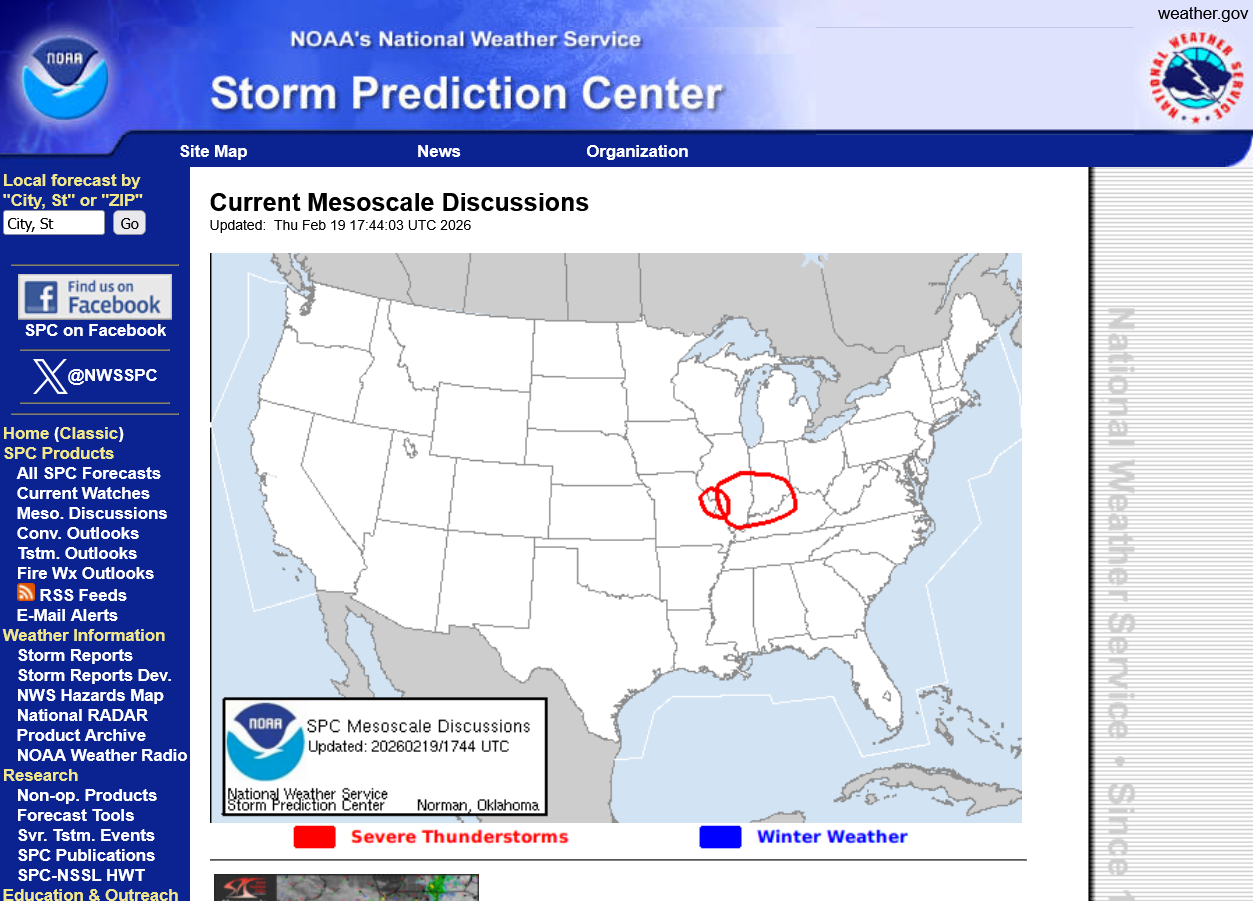
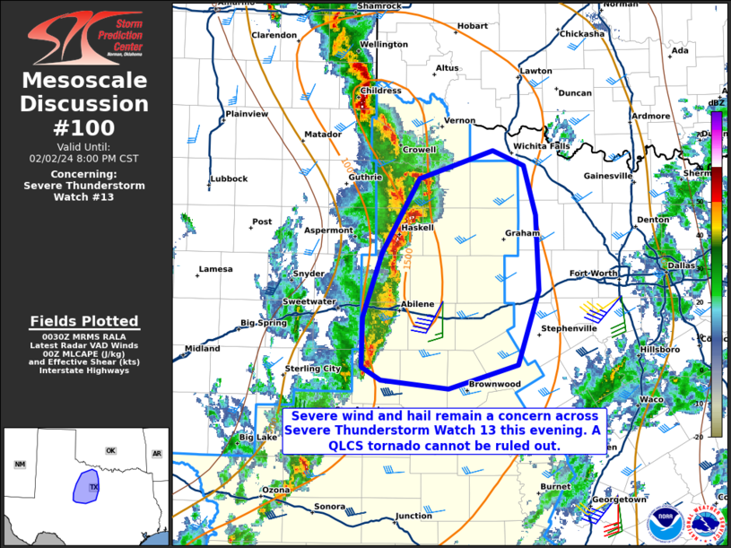
If you want to get a heads up on Storm Prediction Center Watches, you can go to their mesoscale discussion page:
This was the last one:
Current Mesoscale Discussions
Updated: Thu Feb 19 17:11:03 UTC 2026
++++++++++++++
For the latest from the Paducah NWS for this region, us this link(which issues WARNINGS):

Cold season severe thunderstorms do NOT have the same impressive reflectivity signatures that the radar has with warm and humid air thunderstorms(less of the beam is blocked and bouncing back in the drier air). So a discrete tornado producing storm on the radar might not look that impressive!!!
If you want to get a heads up on Storm Prediction Center Watches, you can go to their mesoscale discussion page:
Just out below.
The Storm Prediction Center should be issuing their first TORNADO watch within the next hour or so(early afternoon). It WILL include all of Vanderburgh County.
Freeze frame image at 11:40am below.

https://www.theweatherprediction.com/wxsafety/tornado/
| RATING | Wind Estimate |
| EF0 | 65 - 85 mph |
| EF1 | 86 - 110 mph |
| EF2 | 111 - 135 mph |
| EF3 | 136 - 165 mph |
The difference in damaging power between an EF1 and EF2 is around 5 to 6 times greater.
The difference in damaging power between an EF1 and an EF3 is 30+ times greater.
The good thing is that this will happen in the afternoon, not when we are in bed. By HAPPEN, I'm referring to the RISK, which is all this is right now.
Considering the risk is for an EF3 tornado of 150mph and radar returns are deceptive in cold season severe weather events, DO take any tornado warnings later today very seriously.
TORNADO PUBLIC SAFETY
The Tornado Watch was just issued as expected:
https://www.spc.noaa.gov/products/watch/ww0010.html
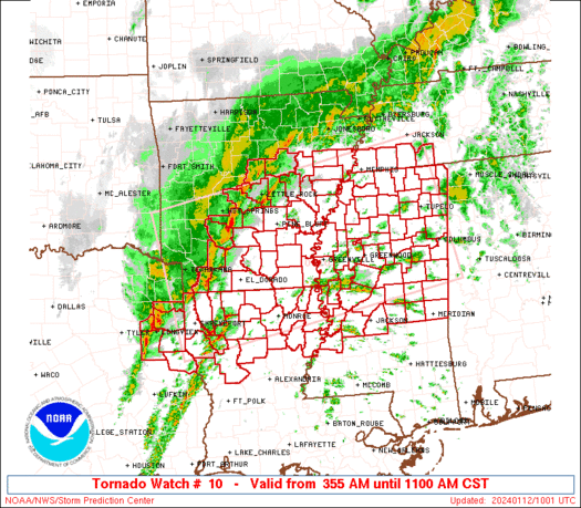
Note the ending time 9pm or 8pm CT. We would USUALLY expect any severe storms to be near the eastern edge of the watch box at 8pm CT, which is almost approaching Cincinnati. Evansville is on the western part of the box and should be having any storms hit early and leave early in the watch box period. ...........but not this time.
However, the actual COLD FRONT is to the west. It's conceivable that a NEW tornado watch box could be issued from a 2nd, independent threat associated with a new perturbation aloft(until the cold front passes thru).
The threat this afternoon is actually associated with a WARM front.
The threat very early this evening will be more from the approaching cold front. Bottom line is that this will be a long lived threat until, maybe 8-9pm?
If you scroll down at the link above, you'll see the most important item of all:
| Probability of 1 or more strong (EF2-EF5) tornadoes | Mod (30%) |
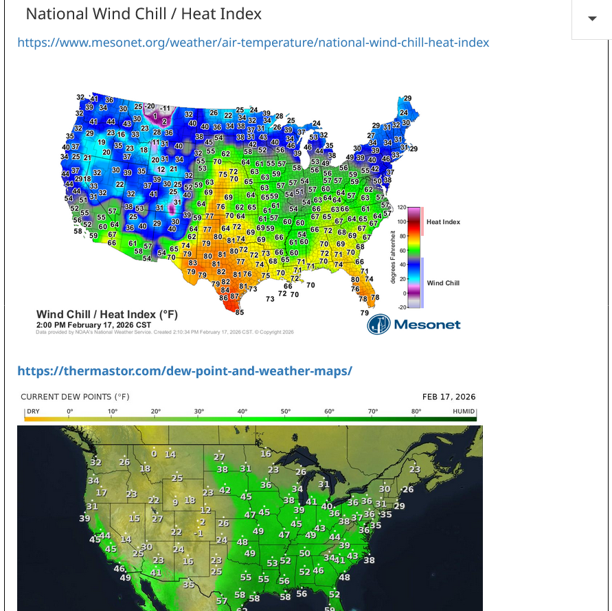
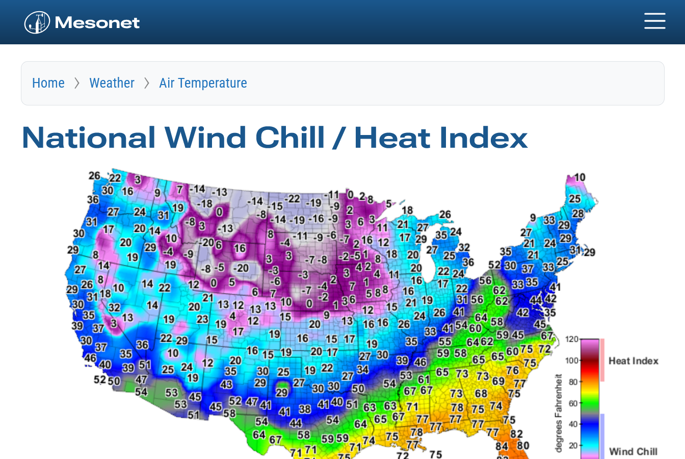
https://www.mesonet.org/weather/air-temperature/national-wind-chill-heat-index

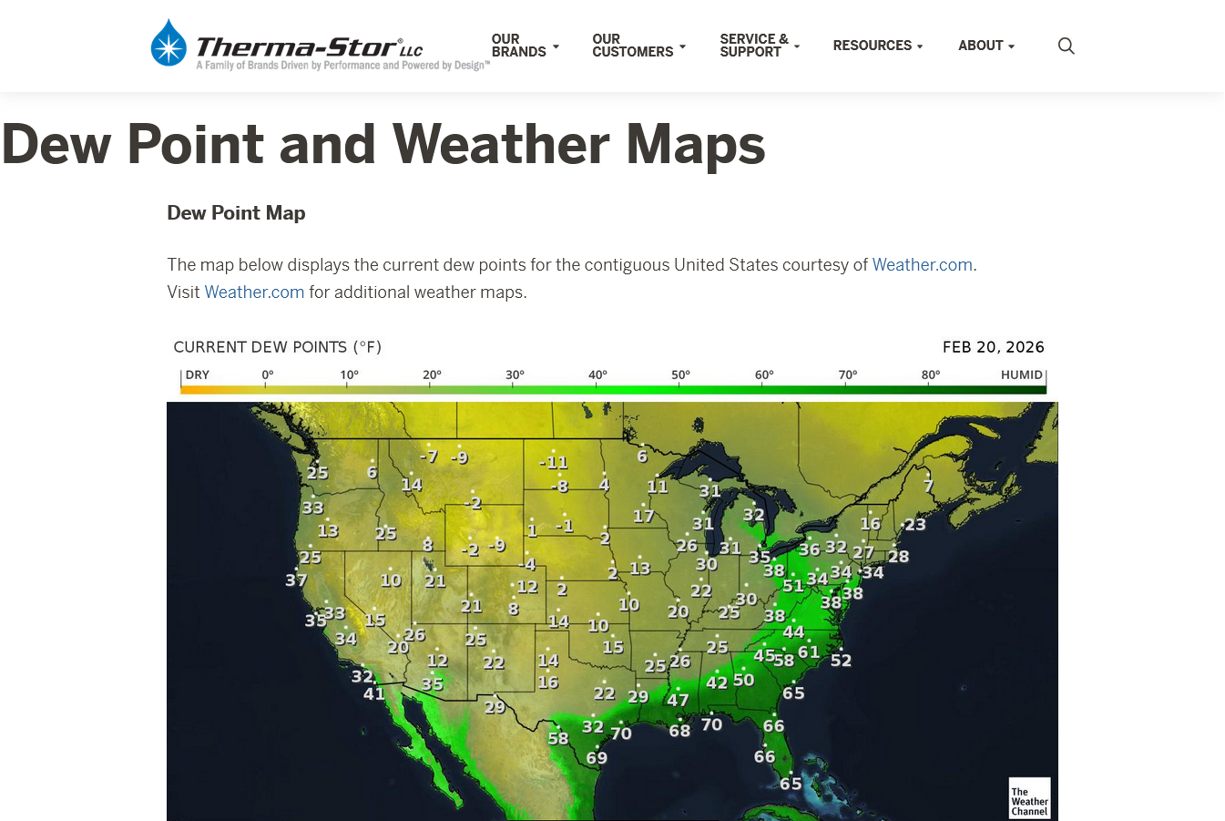
https://thermastor.com/dew-point-and-weather-maps/

Current Conditions below updated every few minutes.
https://www.spc.noaa.gov/exper/mesoanalysis/new/viewsector.php?sector=19

No severe weather to report yet.
I'll be at Oak Hill Elementary for chess for around 2 hours but the thing to do this afternoon is the same as we always do in situations like this during a Tornado Watch that INCLUDES the potential of a 150 mph tornado.
Monitor the local NWS because THEY will issue any and all warnings.
If they issue a severe thunderstorm warning, stay inside a permanent structure and away from windows.
If they issue a tornado warning, go to your safest place(basement or center of the building).
If they issue a tornado warning that includes a reported strong tornado on the ground headed your way, go to the safest place and be prepared to get under a sturdy table or cover your head with a pillow because you can afford to have broken bones/cuts in most places but not on your head so much.
And keep in mind, even with this elevated risk, the chance of any of us being hit directly from a strong tornado this afternoon is still only around 1 in a million.
Because we can identify risks like this in 2026 compared to 100 years ago and go to safer places BEFORE the bad weather hits, look at what technology has done for our lives!!!
Follow the weather closest today at this source below
Warnings will show up on this map:
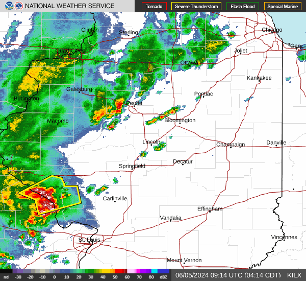
The latest batch of NON severe storms here just after 2:30pm is headed NORTH of Evansville.
I will try to post later this afternoon.
While I was at chess practice at Oak Hill Elementary, the storms moved north as expected. Nothing anywhere close to Evansville. This is actually what we thought with yesterday evening's update using the jet stream dynamics.
The Storm Prediction Center issued this below a couple of hours ago, with their last mesoscale update which is NOT verifying or the NWS previous outlook for the southern part of the area, including Evansville.
Their products are well overdue for an update.
https://www.spc.noaa.gov/products/md/md0100.html
This is from Central IL/IN below:

| Mesoscale Discussion 100 | |
| < Previous MD Next MD > | |
| | |
The Storm Prediction Center trimmed back the tornado watch south of the Ohio River. They are focusing on CENTRAL IN right now.
We could still have an isolated severe storm/tornado for the next several hours in Evansville but the main event is taking shape in CENTRAL IL now into CENTRAL IN.
https://www.spc.noaa.gov/products/md/md0102.html

| Mesoscale Discussion 102 | |
| < Previous MD | |
 c c | |
They trimmed back the tornado watch and shifted everything just north of our area where all the action has been taking place the entire day.
https://www.spc.noaa.gov/products/md/md0102.html
https://www.spc.noaa.gov/products/md/md0103.html

Yesterday's storm has strengthened and moved in to the Great Lakes on Friday, dumping modified Arctic air behind it with gusty winds.
https://www.spc.noaa.gov/exper/mesoanalysis/new/viewsector.php?sector=19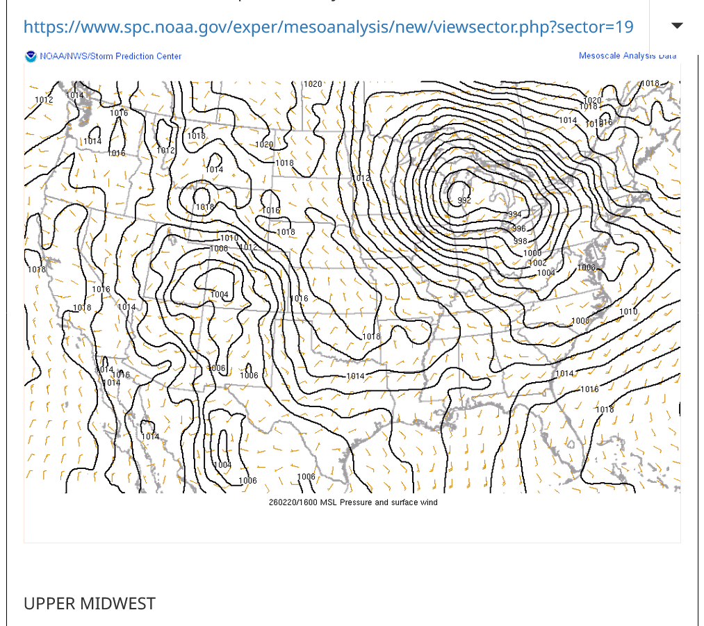
https://www.mesonet.org/weather/air-temperature/national-wind-chill-heat-index
https://thermastor.com/dew-point-and-weather-maps/
Here is a report of the severe weather from last Thursday. All of it just north of Evansville IN.
With regards to the magnitude of severe weather outbreaks, this one didn't go very high up on the intensity or numbers scale and we never expected that.
https://www.spc.noaa.gov/climo/reports/260219_rpts.html

We tried to be very honest about the actual threat in discussions above.
However, there will be times this Spring when we DO have much higher threats that justify being especially vigilant because those times will include the threat of strong/violent tornadoes that are rare but kill the most people. That's when being in a safe place saves lives.
When will those highest risk times be? We will know and identify them WELL BEFORE it happens.
1. When the Storm Prediction Center has at least a moderate, level 4 out of 5 risk. When they have a 5 out of 5 high risk, it's imperative to stay tuned during that type of severe weather outbreak and be ready to act, while still keeping in mind that even during the worst tornado outbreaks, what we are doing is REDUCING the risk of being killed by a tornado from a very small number to a MUCH SMALLER number by taking actions.
2. The Storm Prediction Center will use this verbiage: "This is a particularly dangerous situation".
We know what conditions cause those type of tornadoes with high confidence days in advance but will NEVER be able to predict them with pinpoint accuracy until the storms causing them are in progress,
All tornadoes are absolutely NOT CREATED EQUAL!!!
The total lives lost from 1,000 EF0 tornadoes might not add up to the lives lost from just 1 really bad EF5 tornado!
A 150 mph EF3 wind has 256 times more damaging power than a 75 mph EFO wind!
A 225 mph EF5 wind has 256 X 256 times more damaging power than a 75 mph EFO wind!!!!
65,000 times more damaging power in a strong EF5 tornado compared to an EF0 tornado!!!. That's not a mistake or typo in the math.
That's based on physical laws and tens of thousands of surveys of tornado damage which were used to contruct the Enhanced Fujita tornado scale.
Mike Simon Tornado Damage Intensity; Enhanced Fujita Scale
https://www.youtube.com/watch?v=p-653tSCB68
++++++++++++
Understanding this in 2026 and having the technology to warn people long before the life threatening weather makes it a much, MUCH safer world compared to 100 years ago. People in that age found out about the strong tornadoes or other extreme weather events...............when they were actually getting clobbered by them!
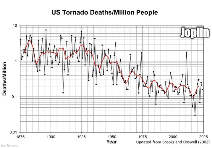
Despite this, there are still limitations based on the worst EF5 tornadoes like the one that struck Joplin, MO in May 2011!
https://en.wikipedia.org/wiki/Joplin_tornado
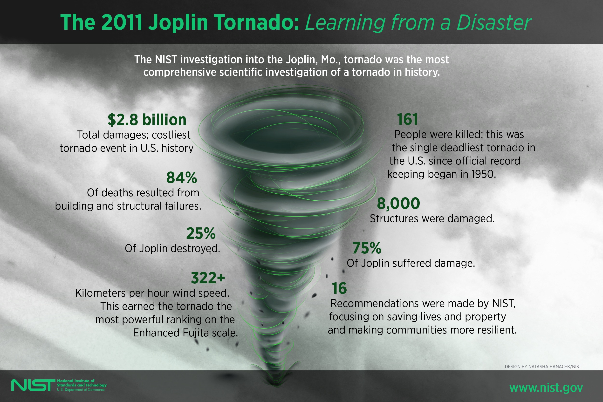
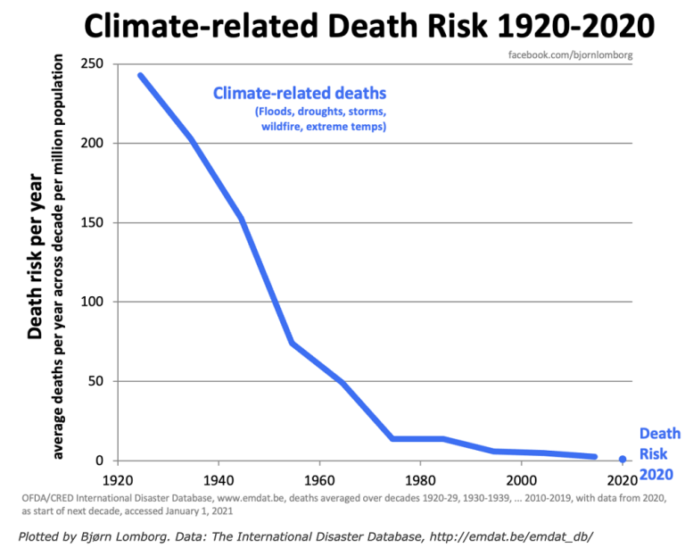
We should note that the scale below is LOGARITHMIC in order to keep the data manageable because of the tremendous drop in values.
The highest numbers on the left top/left that are approaching 10 deaths/million are actually 100+ times greater than the lowest numbers on the right that are LESS THAN .1 deaths/million!
The Joplin tornado in May 2011 caused the huge spike higher and 1 outlying year since the 1970's.
++++++++++++++++++=
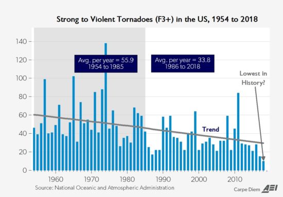
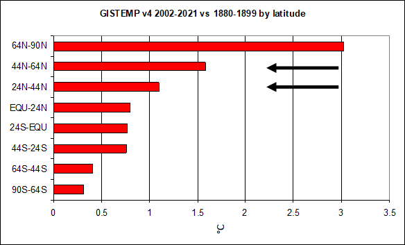
Climate change has been helping too by warming the highest latitudes the most and weakening cold fronts and jet streams! This has reduced the number of the strongest tornadoes by around 50%!
This thread is about TORNADOES not about other impacts from climate change.
May 29th, 2019 by Roy W. Spencer, Ph. D.
Weather becomes LESS extreme in several realms when you reduce the planets temperature contrast with latitude!
Hard freezes coming deep into the SE US early this week, possibly threatening some records, after near alltime record Feb highs just 2-3 days before!
Thanks, very much Larry!
By metmike - Feb. 22, 2026, 11:55 a.m.
++++++++++++
6pm:
Nor'Easter
Started by mikempt - Feb. 22, 2026, 12:53 p.m.
NYC (Central Park)essentially up to 20” snow on 1.75” liquid equivalent as of 1PM! Biggest since Jan of 2016!
Thanks, Larry!
I was getting ready to post this on the NTR forum and I got a call from a chess coach friend that I'd not spoken with for years and was on the phone for 2 hours before sending it out.
https://www.marketforum.com/forum/topic/118086/#118132
++++++++++++++++
Comprehensive snow totals:
By metmike - Feb. 23, 2026, 2:31 p.m.
No threat this week or in the foreseeable future!
This is the best video/visual and data/fact presentation of a tornado I've ever seen. Deserves an award!!!
Mayfield - The Deadliest Tornado Of The Decade
https://www.youtube.com/watch?v=LWZh0fKD5Ww

This was in December 2021. A time of year when violent tornadoes don't usually happen.
 Weather Map