Get all the comprehensive weather here:
https://www.marketforum.com/forum/topic/83844/
Previous threads:
2-27-26: Excessive rains early/mid March
22 responses |
Started by metmike - Feb. 27, 2026, 11:19 a.m.
https://www.marketforum.com/forum/topic/118228/
++++++++++++++++
2-16-26 active weather week!
28 responses |
Started by metmike - Feb. 16, 2026, 7:04 p.m.
https://www.marketforum.com/forum/topic/117950/
The Storm Prediction Center has just elevated their risk to moderate, level 4 of 5 in a small area just south of Chicago.
Their technical forecast philosophy discussion mentions the potential for EF3+ violent tornadoes in that area and possibly the surrounding enhanced, level 3 area.
++++++++++++
https://www.wunderground.com/maps/radar/current

Recent rain amounts:
weathernet.com/total-rainfall-map-24-hours-to-72-hours
+++++++++++++++
Current Hazards at the link below.
For your NWS and county, go to the link below.
Then you can hit any spot on the map, including where you live and it will go to that NWS with all the comprehensive local weather information for that/your county.

New radar product below
Go to: "Select View" then "Local Radar"
Hit the purple circle to see that local radar site
+++++++++++++++++++++++
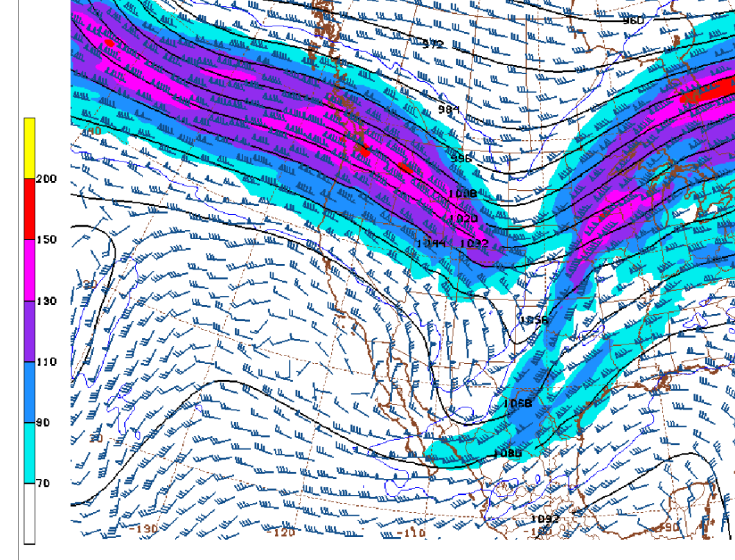
This link below provides some great data. After going to the link, hit "Mesoanalysis" then, the center of any box for the area that you want, then go to observation on the far left, then surface observations to get constantly updated surface observations or hit another of the dozens of choices.

Technical discussion of forecast philosophy here as well as other products to stay on top of today's significant severe storm/tornado threat.:
https://www.spc.noaa.gov/products/outlook/day1otlk.html
++++++++
This threat is MUCH less farther south, tapering to just level 1 by the time we get to the Ohio River.
The higher risk zones are getting clipped by the southeastern part of a jet streak in the Upper Midwest that will greatly enhance the lift, sheer and potential spin.
See the explanations below:
https://www.weather.gov/media/ewx/iwt/SPC_WPC_Differences.pdf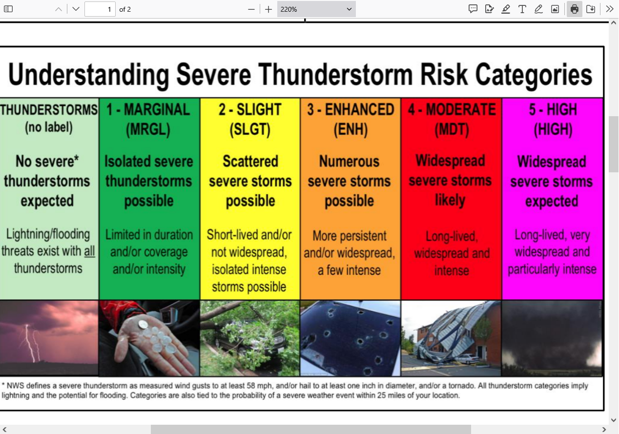
+++++++++++++++++
The type of tornado possible late today/tonight in the moderate risk zone is an EF3+. This means 165 mph+.
Personally, I am not AS impressed with the dynamics as they are but The Storm Prediction Center is better than me at forecasting severe weather!.
Enhanced Fuita scale
https://en.wikipedia.org/wiki/Enhanced_Fujita_scale
| EFU | Unknown | No surveyable damage |
|---|---|---|
| EF0 | 65–85 mph | Light damage |
| EF1 | 86–110 mph | Moderate damage |
| EF2 | 111–135 mph | Considerable damage |
| EF3 | 136–165 mph | Severe damage |
| EF4 | 166–200 mph | Devastating damage |
| EF5 | >200 mph | Incredible damage |
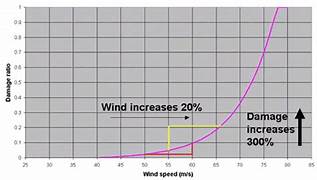
Here's the deal on wind and damage.
As wind increases the damage massively increases on an exponential scale. This applies to ALL wind.
Severe storms and hurricanes and especially tornadoes that have the strongest winds of all, which means the tornadoes with winds over 150 mph have incredible damage.
+++++++++++
+++++++++++++++++++++
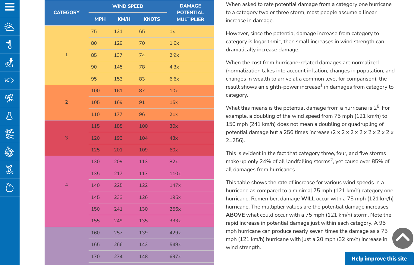
A 150 mph wind does 256X more damage than a 75 mph wind. Let's repeat that. A 150 mph wind does 256x more damage than a 75 mph wind!
Hurricane Damage Potential
https://www.noaa.gov/jetstream/tc-potential
++++++++++++
Less than 1% of tornadoes are F4 or F5 but they kill 67% of the people!
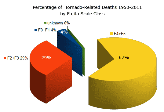
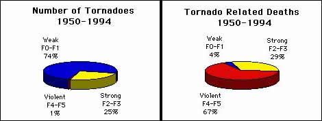
Note that the majority of tornadoes, F0 and F1= 74%(on the old scale) only killed 4% of people and they were probably outside or in a mobile home.
The F4 and F5's were just 1% but caused 67% of deaths.
+++++++++++++++++++
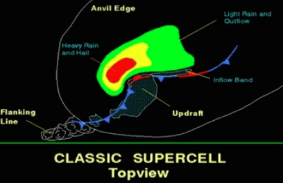
https://www.weather.gov/ama/supercell
++++++++++++
Excellent presentation at this link below that describes the different types of tornadoes and the damage they cause. Keep in mind that the EF4 and EF5 tornadoes are extremely rare. Less than 1% of tornadoes are this strong.
The EF4 and EF5 tornadoes will usually have the HIGH, level 5 risk earlier that day.
Mike Simon Tornado Damage Intensity; Enhanced Fujita Scale
https://www.youtube.com/watch?v=p-653tSCB68
80''s almost as far north as Chicago right now.
The 30's in eastern WI are from the cold water along the western shore of Lake Michigan.
Below freezing wind chill in the Upper Midwest.
https://www.mesonet.org/weather/air-temperature/national-wind-chill-heat-index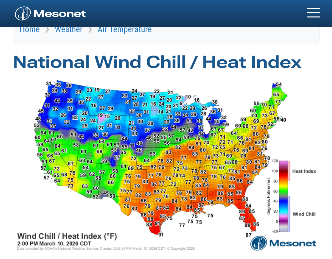
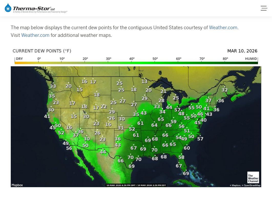
Pretty high dew points for the month of March!
Current Conditions below updated every few minutes.
https://www.spc.noaa.gov/exper/mesoanalysis/new/viewsector.php?sector=19

Map at 2pm below: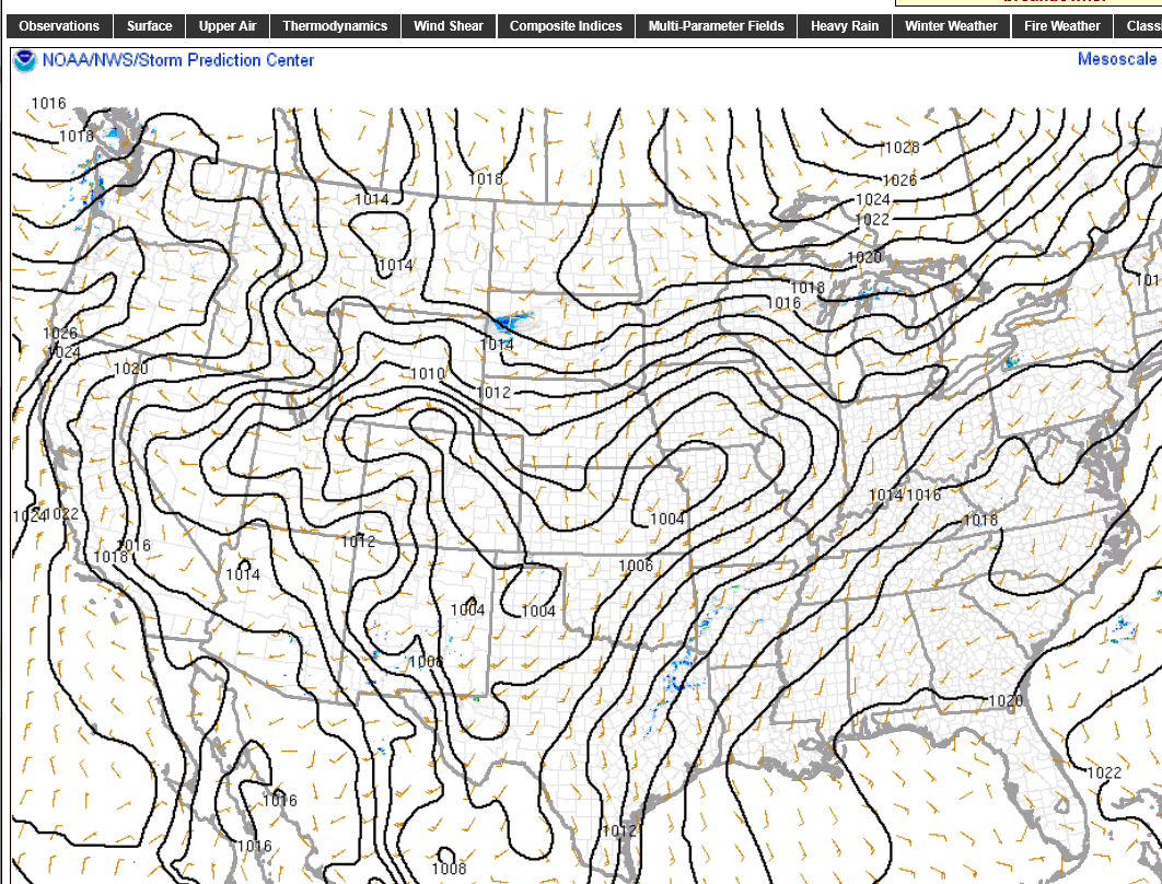
Regardless of the current risk, we should all be tremendously grateful for the technology of this age that is saving countless lives by our ability to predict the risks well in advance and warn people BEFORE the life threatening weather hits so that we can go to safer places.
Re: Re: Re: Re: Re: Re: Re: Re: : 2-16-26 active weather week!
By metmike - Feb. 21, 2026, 10:58 a.m.
Here is a report of the severe weather from last Thursday. All of it just north of Evansville IN.
With regards to the magnitude of severe weather outbreaks, this one didn't go very high up on the intensity or numbers scale and we never expected that.
https://www.spc.noaa.gov/climo/reports/260219_rpts.html

We tried to be very honest about the actual threat in discussions above.
However, there will be times this Spring when we DO have much higher threats that justify being especially vigilant because those times will include the threat of strong/violent tornadoes that are rare but kill the most people. That's when being in a safe place saves lives.
When will those highest risk times be? We will know and identify them WELL BEFORE it happens.
1. When the Storm Prediction Center has at least a moderate, level 4 out of 5 risk. When they have a 5 out of 5 high risk, it's imperative to stay tuned during that type of severe weather outbreak and be ready to act, while still keeping in mind that even during the worst tornado outbreaks, what we are doing is REDUCING the risk of being killed by a tornado from a very small number to a MUCH SMALLER number by taking actions.
2. The Storm Prediction Center will use this verbiage: "This is a particularly dangerous situation".
We know what conditions cause those type of tornadoes with high confidence days in advance but will NEVER be able to predict them with pinpoint accuracy until the storms causing them are in progress,
All tornadoes are absolutely NOT CREATED EQUAL!!!
The total lives lost from 1,000 EF0 tornadoes might not add up to the lives lost from just 1 really bad EF5 tornado!
A 150 mph EF3 wind has 256 times more damaging power than a 75 mph EFO wind!
A 225 mph EF5 wind has 256 X 256 times more damaging power than a 75 mph EFO wind!!!!
65,000 times more damaging power in a strong EF5 tornado compared to an EF0 tornado!!!. That's not a mistake or typo in the math.
That's based on physical laws and tens of thousands of surveys of tornado damage which were used to contruct the Enhanced Fujita tornado scale.
Mike Simon Tornado Damage Intensity; Enhanced Fujita Scale
https://www.youtube.com/watch?v=p-653tSCB68
++++++++++++
Understanding this in 2026 and having the technology to warn people long before the life threatening weather makes it a much, MUCH safer world compared to 100 years ago. People in that age found out about the strong tornadoes or other extreme weather events...............when they were actually getting clobbered by them!
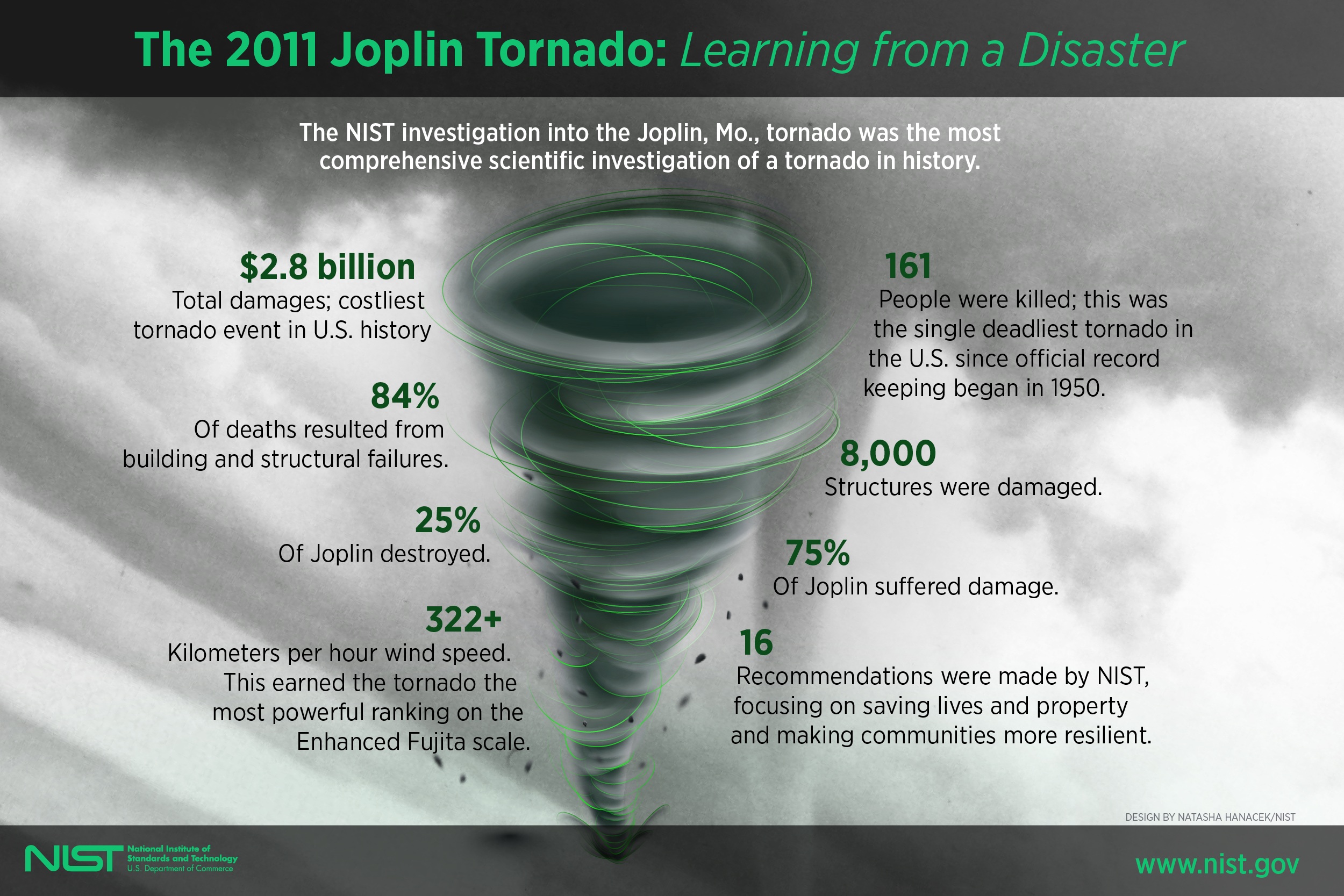
Despite this, there are still limitations based on the worst EF5 tornadoes like the one that struck Joplin, MO in May 2011!
https://en.wikipedia.org/wiki/Joplin_tornado
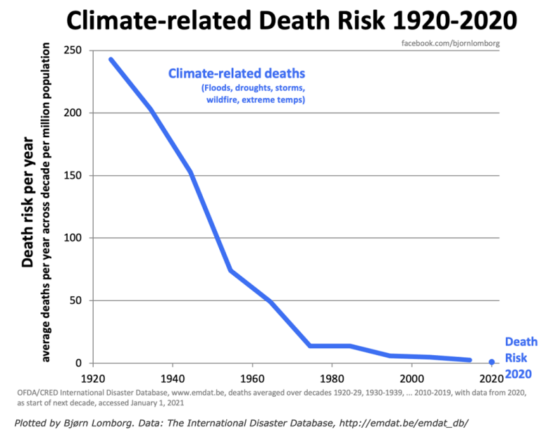
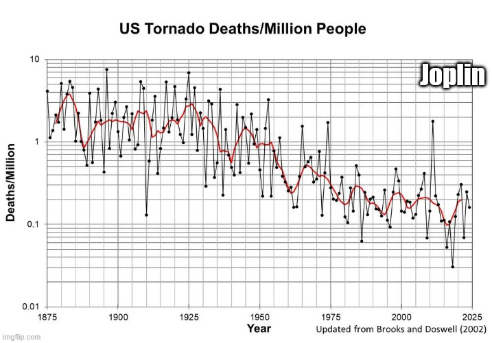
We should note that the scale below is LOGARITHMIC in order to keep the data manageable because of the tremendous drop in values.
The highest numbers on the left top/left that are approaching 10 deaths/million are actually 100+ times greater than the lowest numbers on the right that are LESS THAN .1 deaths/million!
The Joplin tornado in May 2011 caused the huge spike higher and 1 outlying year since the 1970's.
++++++++++++++++++=
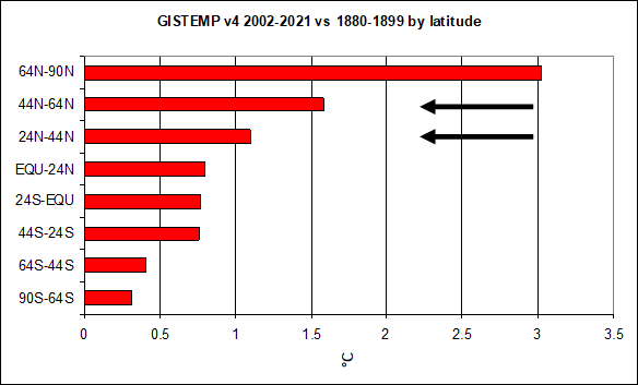
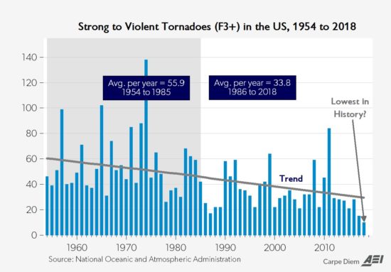
Climate change has been helping too by warming the highest latitudes the most and weakening cold fronts and jet streams! This has reduced the number of the strongest tornadoes by around 50%!
This thread is about TORNADOES not about other impacts from climate change.
May 29th, 2019 by Roy W. Spencer, Ph. D.
Weather becomes LESS extreme in several realms when you reduce the planets temperature contrast with latitude!