Thanks joj!
This is part of a many months long weather pattern with the storm track and jet stream coming out of the Pacific and aimed at the mid section of the country. The weak El Nino in the tropical Pacific is adding some energy/moisture.
2018 was the 3rd wettest year on record in the US and you'll note that the area on the map below in light purple shade across N. IA was THE wettest year ever in 2018, so soils have been saturated and rivers high in that area. :
https://www.ncdc.noaa.gov/sotc/national/201813/supplemental/page-6/
| Rank by Area | Year | Extent |
|---|---|---|
| Largest | 1941 | 10.5% |
| 2nd | 1983 | 7.7% |
| 3rd | 2018 | 6.4% |
| 4th | 2011 | 4.6% |
| 5th | 1915 | 3.8% |
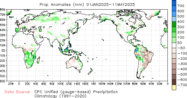
Since then, much of this same area has continued to experience above average rainfall. The map below is global precip vs average for 2019.

The map below is precip % average from the past 2 months for the US.

As a result, soil moisture has remained high in a large area of the Midwest with pockets of soil moisture being saturated, including the area thats experiencing the flooding in the story.

So last weeks heavy rains in that area(4+ inches), on top of saturated ground resulted in excessive runoff into the already high Mississippi River.
7 day rainfall totals below.

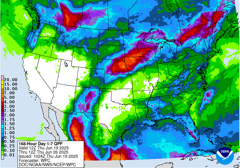
The bad news is that there is more rain on the way next week:
7 Day Total precipitation below:
http://www.wpc.ncep.noaa.govcdx /qpf/p168i.gif?1530796126

The good news this morning is that weather models show a shift southward of the heavy rains in week 2 and this would allow for some welcome drier weather for many areas of the Midwest.

well, until it shifts back north again MM. We were a 20% chance today. It has now set in to be the all day type of rain you die for in August
One thing to note, since its been a frequent topic here every time there is extreme weather, the amount of moisture added to the atmosphere with a 1 deg. C increase in the global temperature is around 6%.
Not 600% or even 60% more moisture but 6% more moisture. This increases the amount of rains, especially in heavy downpours and adds to amounts from weather events like this..........and this is a weather event.
A discussion this week about whether this is the new normal, maybe did not make that clear. Rainfall has increased slightly because of climate change but this current WEATHER pattern is NOT the new normal. It still represents the upper boundary of extreme from both the old climate and new climate both of which rarely occur.
Rains with the new climate, will be heavier in that upper boundary.
In 2012, when we had our first major drought in 24 years.........a record for longest ever without a drought, we had similar concerns about droughts and climate change.
This is human nature and the nature of today's access to information. When extreme weather is happening it always seems more extreme as we witness and read about it.
It's still close to the wettest since records have been kept in several locations around the Midwest because of this current weather pattern. I can assure you, with absolute confidence, that once the El Nino weakens/and this weather pattern shifts, like it has every other time in the past, things will dry out and we will go back closer to our "average" b like we always did before. It may be later this month, or it might be later this Summer and before then, more waves of heavy rains set new records.
However, it will be extraordinarily difficult to break the Summer 1993 rainfall records in the Midwest. I give it a 10% chance of something like that repeating.
One should note that our "average" has always included a bunch of extremes with much above and much below average. What would be most extraordinary with climate is if it did not continue to feature the expected anomalous weather.
Additional discussion here:
Related discussions:
What if this weather is the new normal ?
Started by mcfarmer - April 30, 2019, 8:40 p.m.
https://www.marketforum.com/forum/topic/28957/
Excess rain
Started by cliff-e - May 3, 2019, 6:55 a.m.
https://www.marketforum.com/forum/topic/29183/
Worst floods in World History/US rain records
Started by metmike - May 4, 2019, 11:56 p.m.
https://www.marketforum.com/forum/topic/29362/
Grains/Corn May 2, 2019
https://www.marketforum.com/forum/topic/29118/
I decided to look back on records to see when the greatest flooding on the Mississippi occurred. Turns out that the worst flooding in this countries history occurred 92 years ago (glad that the internet gives us access to weather records).
https://www.weather.gov/media/jan/JAN/Hydro/Flood_History_MS.pdf
"The Great Mississippi Flood of 1927 was the most destructive flood in United States history. This flood extended across Illinois, Indiana, Missouri, Kentucky, Texas, Oklahoma, Kansas, Tennessee, Arkansas, Mississippi, and Louisiana. At one point the river was approximately 80 miles wide near Vicksburg, MS. The flooding was a result of persistent heavy rainfall across the Central U.S. starting in August 1926 and continuing through the spring of 1927. As unprecedented amounts of run-off from the different tributaries combined, extreme water levels churned by wind overwhelmed the levees protecting the Mississippi Valley floodplains, breaching the flood defenses as the water traveled southward. It was not until August 1927 that the last of the floodwaters had flowed into the Gulf of Mexico.For Mississippi, the most significant flooding"
This is the link that goes back the farthest with regards to flooding on the lower Mississippi:
The worst flooding, by far was in 1927, followed by 1973, then 1937.
https://www.weather.gov/lix/ms_flood_history
| 1927 | January-May | The greatest flood in modern history on the Lower MS River! |
I'm looking for Upper Mississippi records now.
Here a good link with information regarding flooding along the entire Mississippi River.
https://en.wikipedia.org/wiki/Mississippi_River_floods
Main article: Great Mississippi and Missouri Rivers Flood of 1993
The flood occurred on the Mississippi and Missouri rivers and their tributaries between April to October 1993. The flooded area totaled around 30,000 square miles (80,000 km²)[14] and was the worst since the Great Mississippi Flood of 1927 as measured by duration, square miles inundated, persons displaced, crop and property damage and number of record river levels.
On further review, we DID find a worse flood than 1993 on the Upper Mississippi:
https://en.wikipedia.org/wiki/Mississippi_River_floods#Flood_of_1788
Main article: Great Flood of 1844
The largest flood ever recorded on the Missouri River and Upper Mississippi River in terms of discharge. The adjusted economic impact was not as great as subsequent floods because of the small population in the region at the time.This flood was particularly devastating since the region had few if any levees at the time. Among the hardest hit were the Wyandot who lost 100 people in the diseases that occurred after the flood. The flood also is the highest recorded for the Mississippi River at St. Louis. After the flood, Congress in 1849 passed the Swamp Act providing land grants to build stronger levees
So to review:
https://en.wikipedia.org/wiki/Mississippi_River_floods#Flood_of_1788
Worst flooding in USA history, looking at all rivers--1927
Worst flooding for the lower Mississippi River.
1. 1927
2. 1973
3. 1937
4. 2011
Worst flooding for the Upper Mississippi River using actual discharge/levels
1. 1844
2. 1993
So although recent rains have been excessive and the most in over 2 decades for the Midwest and rains HAVE increased from climate change and an atmosphere that can hold 6% more moisture, we have not exceeded records in the past.........other than at isolated locations, which is not unusual for extreme weather events.