The American Storm@BigJoeBastardi
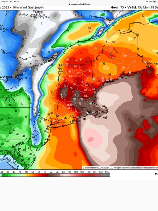
3km nam with 80-100 mph wind gusts Sunday pm and night
I know it’s the NAM. And most likely a bit overdone. But here’s the max winds it’s showing for storm Sunday night/Monday Am. Ceiling def higher than last storm…and more widespread.
Hum Dinger of a storm system! This is almost all RAIN except on the western side, some minor accumulations.
Current Hazards at the link below.
Go to the link below, hit hazards box in the top right hand corner(it will also define all the color codes), if its not already in the hazards mode when you load the link.
Then you can hit any spot on the map, including where you live and it will go to that NWS with all the comprehensive local weather information for that/your county.

This link below provides some great data. After going to the link, hit "Mesoanalysis" then, the center of any box for the area that you want, then go to observation on the far left, then surface observations to get constantly updated surface observations or hit another of the dozens of choices.
 |
Snowfall Probability Forecasts
https://www.wpc.ncep.noaa.gov/wwd/winter_wx.shtml
The following charts depict the probability of snowfall reaching or exceeding the specified amount.
|
Current issuance cycle: 12Z (updated 0939Z, December 18, 2023)
| Day 1 | Day 2 | Day 3 |
≥ 4 inches | ≥ 4 inches | ≥ 4 inches |
≥ 8 inches | ≥ 8 inches | ≥ 8 inches |
≥ 12 inches | ≥ 12 inches | ≥ 12 inches |
+++++++++++++++++++++++
Day 4-7 Outlook
Current issuance cycle: 12Z (updated 0338Z, December 18, 2023)
|