
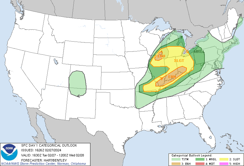
Enhanced risk area late today, Tuesday into early Wednesday.
https://www.spc.noaa.gov/products/outlook/day1otlk.html
Local NWS from Paducah area of responsibility, including southern Indiana:


Tracking the storm:
Current Hazards at the link below.
Go to the link below, hit hazards box in the top right hand corner(it will also define all the color codes), if its not already in the hazards mode when you load the link.
Then you can hit any spot on the map, including where you live and it will go to that NWS with all the comprehensive local weather information for that/your county.

New radar product below
Go to: "Select View" then "Local Radar"
Hit the purple circle to see that local radar site
+++++++++++++++++++++++
This link below provides some great data. After going to the link, hit "Mesoanalysis" then, the center of any box for the area that you want, then go to observation on the far left, then surface observations to get constantly updated surface observations or hit another of the dozens of choices.
 |
Tracking the weather:
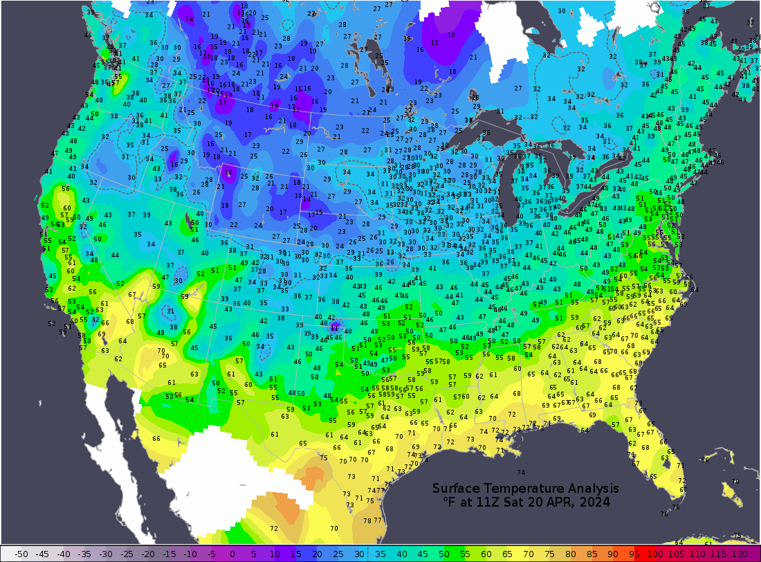
Current temperatures:
https://thermastor.com/dew-point-and-weather-maps/

Current Conditions below updated every few minutes.
UPPER MIDWEST
https://www.spc.noaa.gov/exper/mesoanalysis/new/viewsector.php?sector=13#


https://www.spc.noaa.gov/exper/mesoanalysis/new/viewsector.php?sector=13#

LOWER MIDWEST
https://www.spc.noaa.gov/exper/mesoanalysis/new/viewsector.php?sector=20

https://www.spc.noaa.gov/exper/mesoanalysis/new/viewsector.php?sector=20#

https://www.spc.noaa.gov/exper/mesoanalysis/new/viewsector.php?sector=20# 
SOUTHCENTRAL
https://www.spc.noaa.gov/exper/mesoanalysis/new/viewsector.php?sector=15#
SOUTHEAST
https://www.spc.noaa.gov/exper/mesoanalysis/new/viewsector.php?sector=18#


https://www.spc.noaa.gov/products/md/

https://www.spc.noaa.gov/products/md/md0167.html

TORNADO WATCH to be issued for this area above in the next couple of hours(before Midnight).
That would include all the areas surrounding Evansville, IN.
Scroll up for previous posts
As expected, they just issued the tornado watch......until 5am but the threat will be over BEFORE then.
Nothing for at least a couple of hours and keep in mind that we see this type of threat at least a dozen times every year and this is NOT one of the highest threats.
Above this is a MODERATE risk and above that is a HIGH risk.
We see those EVEN HIGHER RISK categories several times/year.
This one has people freaking out because they'll be in bed.
You can monitor the weather overnight. Look at local radar images.
If there are storms that start blossoming and generate WARNINGS to your west, it's time to be ready to go to a safe place if a TORNADO WARNING is issued for your county.
Know that, even when we have an enhanced risk event like tonight, the chance of you being injured or killed in a car accident on your way to work tomorrow is MUCH higher than this risk tonight........by many thousands of times.
However, we can identify the highest risks tonight. You go to the safe spot in your home if your area is being targeted by a violent tornado(violent tornadoes are extremely rare).........and reduce the potential harm EVEN MORE!
80%+ of tornadoes WILL NOT HURT YOU IN YOUR HOUSE.
The top strongest 5% and especially top 2% are the killers. Those are extraordinarily rare and not likely this time.
https://en.wikipedia.org/wiki/Tornado_intensity


A key element with STRONG and VIOLENT tornadoes is a powerful jet stream.
The sliver of yellow is at the top of the color bar and represents 200 KNOTS/hour at the 250 mb level on the GFS model.
This is around 230+ mph!
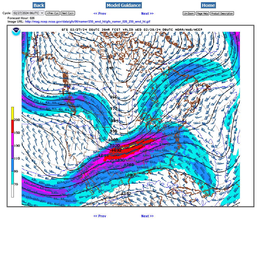
How high up is 250 mb??? Around 34,000 feet, which is around 6.5 miles above the ground.
https://www.boqueteweather.com/millibars_altitude.htm
| Level | Standard Height | |
| 1000 MB | 364 ft | 111 m |
| 925 MB | 2498 ft | 762 m |
| 850 MB | 4781 ft | 1458 m |
| 700 MB | 9882 ft | 3013 m |
| 500 MB | 18289 ft | 5576 m |
| 400 MB | 23574 ft | 7187 m |
| 300 MB | 30065 ft | 9166 m |
| 250 MB | 33999 ft | 10366 m |
| 200 MB | 38662 ft | 11787 m |
| [Boqueteweather.com] | ||
| Copyright © 2007 Boqueteweather.com | ||
++++++++++++++++++
https://oceanservice.noaa.gov/facts/nautical-mile-knot.html
Nautical miles are used to measure the distance traveled through the water. A nautical mile is slightly longer than a mile on land, equaling 1.1508 land-measured (or statute) miles. The nautical mile is based on the Earth’s longitude and latitude coordinates, with one nautical mile equaling one minute of latitude.
+++++++++++++
https://www.maximum-inc.com/learning-center/what-is-knot-speed/
++++++++++++++++++
https://www.thoughtco.com/measuring-wind-speed-in-knots-3444011
| Unit of Measure | |
|---|---|
| Surface winds | mph |
| Tornadoes | mph |
| Hurricanes | kts (mph in public forecasts) |
| Station Plots (on weather maps) | kts |
| Marine forecasts | kts |
+++++++++++++++++++
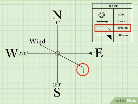
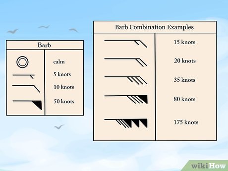
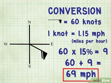
https://www.wikihow.com/Read-Wind-Barbs
Here at 1:10am CST, Storms just started to erupt quickly in the last 40 minutes, along the IL/KY border.
Heading E/NE, maybe staying south of Evansville.
Another mostly isolated strong storm in IL, aiming towards Vincennes.
Additional smaller cells in IL. Any one of which could amplify quickly.
Looks we're going to see several discrete small lines of storms forming initially. Possibly coalescing/congealing into 1 long bowing line before dawn And AFTER the cold front and threat has passed east of Evansville!
Go to this link for the latest radar images and warnings:

The threat for severe weather is east and southeast of Evansville here, just after 4am.


This was the new tornado watch issued over an hour ago:
https://www.spc.noaa.gov/products/watch/ww0028.html

++++++++++++++
Not very many storm reports for the Evansville area and no tornadoes close to us as of 5am CST. …..with the threat now over. As mentioned previously, we have HIGHER risk assessments than what this was on several occasions in the year but this one seemed scarier because it’s February and a nocturnal event.
This map is updated thru early today at 5am, I believe
https://www.spc.noaa.gov/climo/reports/today.html

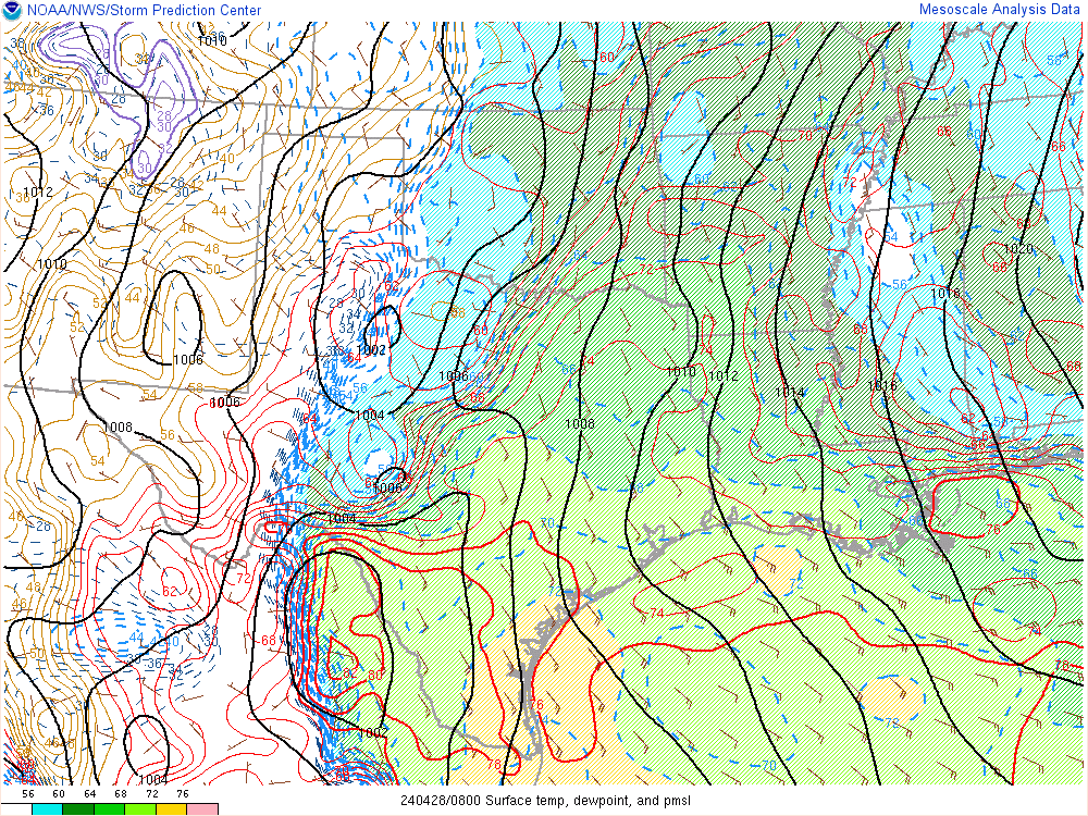
Look at what happened to the temperature/wind when the cold front went thru 2+ hours ago.
Mid =72 Deg. SW wind 16 G-30mph
1am =71 Deg. SW wind 20 G-28mph
2am =72 Deg. SW wind 20 G-33mph
3am =51 Deg. NW wind 18 G-41mph
4am =44 Deg. NW wind 16 G-32mph
https://w1.weather.gov/data/obhistory/KEVV.html
| Evansville, Evansville Regional Airport |
| Enter Your "City, ST" or zip code |
| metric |
| Max. | Min. | ||||||||||||||||
|---|---|---|---|---|---|---|---|---|---|---|---|---|---|---|---|---|---|
| Air | Dwpt | 6 hour | altimeter (in) | sea level (mb) | 1 hr | 3 hr | 6 hr | ||||||||||
| D a t e | Time (cst) | Wind (mph) | Vis. (mi.) | Weather | Sky Cond. | Temperature (ºF) | Relative Humidity | Wind Chill (°F) | Heat Index (°F) | Pressure | Precipitation (in.) | ||||||
| 28 | 03:54 | NW 16 G 32 | 10.00 | Mostly Cloudy | SCT036 BKN100 | 44 | 36 | 73% | 37 | NA | 29.61 | 1002.6 | |||||
| 28 | 02:54 | NW 18 G 41 | 8.00 | Light Rain | FEW038 SCT065 OVC085 | 51 | 45 | 80% | NA | NA | 29.55 | 1000.3 | |||||
| 28 | 01:54 | SW 20 G 33 | 10.00 | Mostly Cloudy | BKN050 | 72 | 58 | 61% | NA | NA | 29.45 | 996.8 | |||||
| 28 | 00:54 | SW 20 G 28 | 10.00 | Partly Cloudy | SCT044 | 71 | 58 | 63% | NA | NA | 29.46 | 997.4 | |||||
| 27 | 23:54 | SW 16 G 30 | 10.00 | A Few Clouds | FEW046 | 72 | 58 | 73 | 71 | 61% | NA | NA | 29.45 | 997.0 | |||
The maps on this page above are constantly updated and show the colder air pouring in as well as the distinct kink in the isobars/pressure pattern from the cold front having passed well to our east now: