Severe Storm Risk......updated daily(days 1 and 2 twice daily).
https://www.spc.noaa.gov/products/outlook/
Current Day 1 Outlook | |
Current Day 2 Outlook | |
Current Day 3 Outlook | |
Current Day 4-8 Outlook |
Excessive rain threat.
https://www.wpc.ncep.noaa.gov/qpf/excess_rain.shtml
Current Day 1 Forecast
Day 1 Threat Area in Text Format
Current Day 2 Forecast |
Day 3 outlook

Jean's favorite guy:
You can scroll down and get almost the entire comprehensive weather picture updated constantly here.
Current Hazards at the link below.
Go to the link below, hit hazards box in the top right hand corner(it will also define all the color codes), if its not already in the hazards mode when you load the link.
Then you can hit any spot on the map, including where you live and it will go to that NWS with all the comprehensive local weather information for that/your county.

New radar product below
Go to: "Select View" then "Local Radar"
Hit the purple circle to see that local radar site
+++++++++++++++++++++++
This link below provides some great data. After going to the link, hit "Mesoanalysis" then, the center of any box for the area that you want, then go to observation on the far left, then surface observations to get constantly updated surface observations or hit another of the dozens of choices.
 |
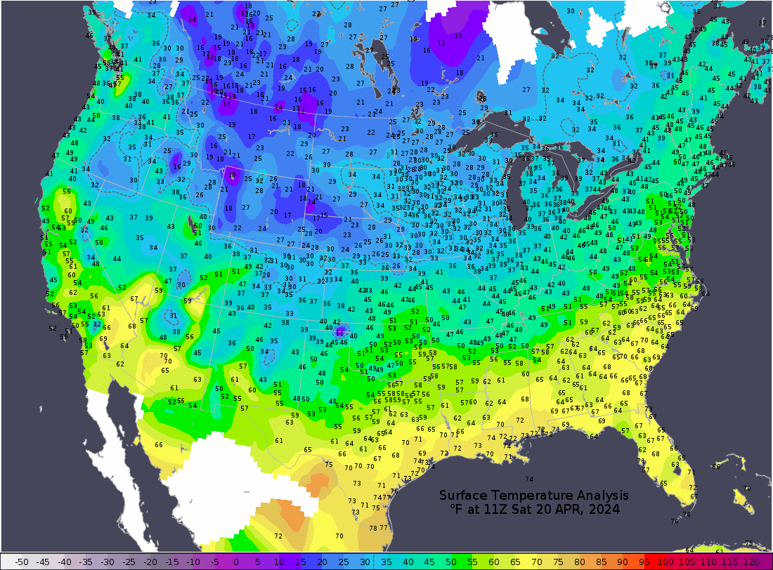
Current temperatures:
https://thermastor.com/dew-point-and-weather-maps/

Current Conditions below updated every few minutes.
UPPER MIDWEST
https://www.spc.noaa.gov/exper/mesoanalysis/new/viewsector.php?sector=13#


https://www.spc.noaa.gov/exper/mesoanalysis/new/viewsector.php?sector=13#

LOWER MIDWEST
https://www.spc.noaa.gov/exper/mesoanalysis/new/viewsector.php?sector=20

https://www.spc.noaa.gov/exper/mesoanalysis/new/viewsector.php?sector=20#

https://www.spc.noaa.gov/exper/mesoanalysis/new/viewsector.php?sector=20# 
SOUTHCENTRAL
https://www.spc.noaa.gov/exper/mesoanalysis/new/viewsector.php?sector=15#
SOUTHEAST
https://www.spc.noaa.gov/exper/mesoanalysis/new/viewsector.php?sector=18#

History of severe weather with this system:
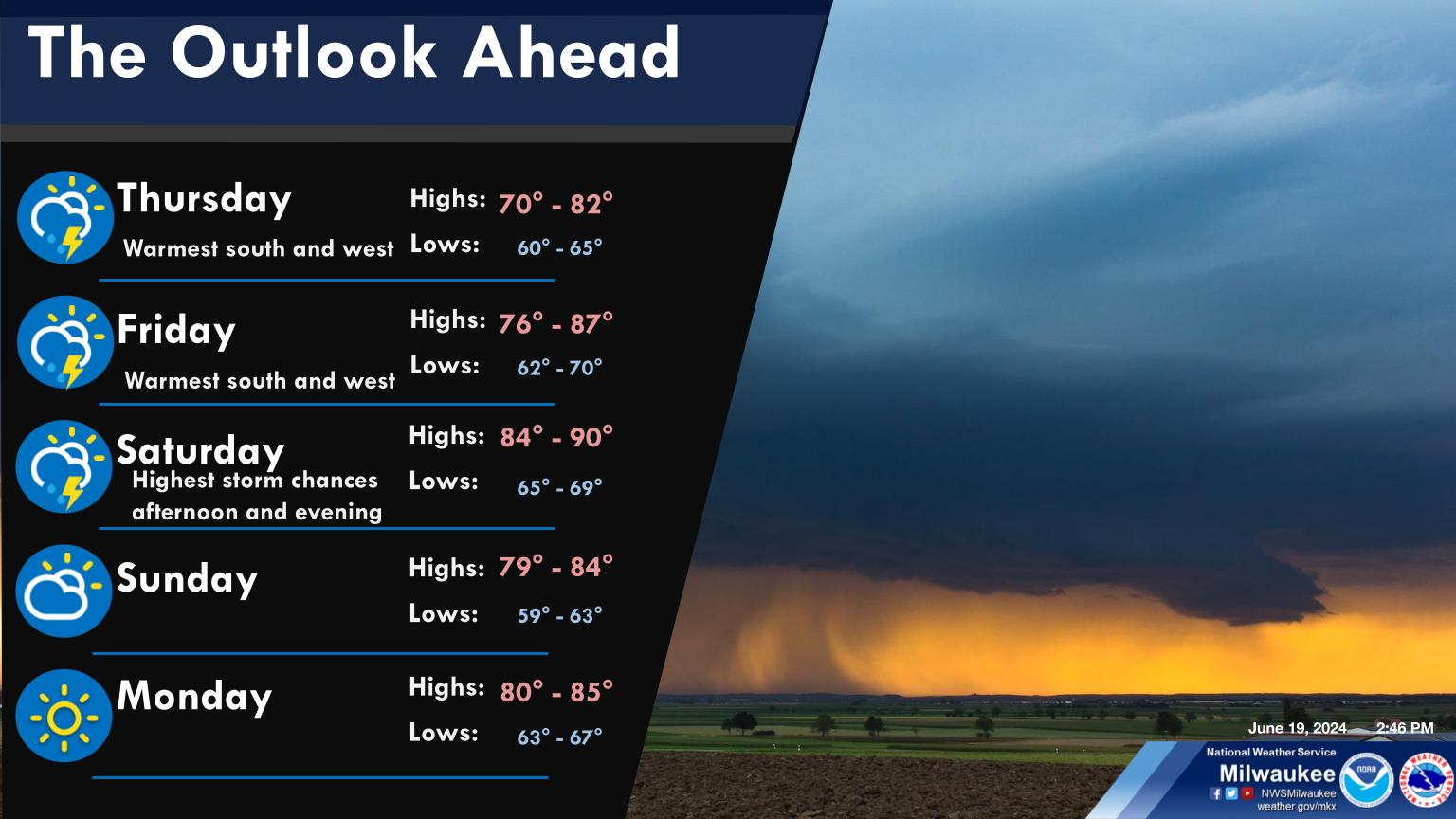
Thursday:

Friday: 83 tornadoes

Late afternoon Saturday, so far:

250 mb Jet stream later today:

How high up is 250 mb??? Around 34,000 feet, which is around 6.5 miles above the ground.
https://www.boqueteweather.com/millibars_altitude.htm
| Level | Standard Height | |
| 1000 MB | 364 ft | 111 m |
| 925 MB | 2498 ft | 762 m |
| 850 MB | 4781 ft | 1458 m |
| 700 MB | 9882 ft | 3013 m |
| 500 MB | 18289 ft | 5576 m |
| 400 MB | 23574 ft | 7187 m |
| 300 MB | 30065 ft | 9166 m |
| 250 MB | 33999 ft | 10366 m |
| 200 MB | 38662 ft | 11787 m |
| [Boqueteweather.com] | ||
| Copyright © 2007 Boqueteweather.com | ||
++++++++++++++++++
https://oceanservice.noaa.gov/facts/nautical-mile-knot.html
Nautical miles are used to measure the distance traveled through the water. A nautical mile is slightly longer than a mile on land, equaling 1.1508 land-measured (or statute) miles. The nautical mile is based on the Earth’s longitude and latitude coordinates, with one nautical mile equaling one minute of latitude.
+++++++++++++
https://www.maximum-inc.com/learning-center/what-is-knot-speed/
++++++++++++++++++
https://www.thoughtco.com/measuring-wind-speed-in-knots-3444011
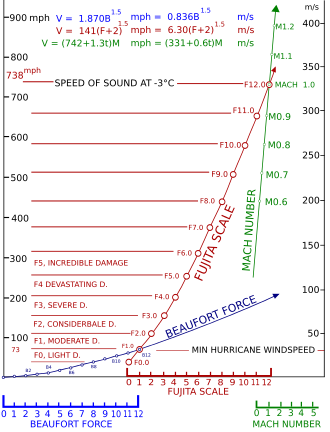
| Unit of Measure | |
|---|---|
| Surface winds | mph |
| Tornadoes | mph |
| Hurricanes | kts (mph in public forecasts) |
| Station Plots (on weather maps) | kts |
| Marine forecasts | kts |
+++++++++++++++++++
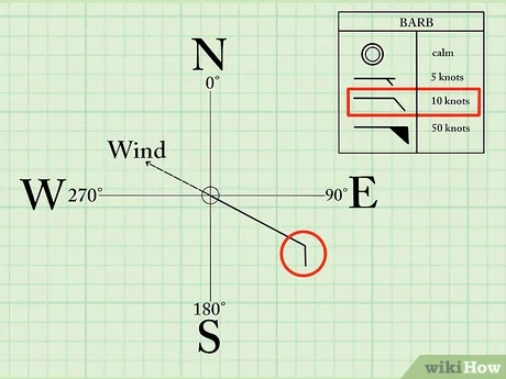
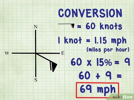
https://www.wikihow.com/Read-Wind-Barbs

Regional/local NWS offices:
https://www.nws.noaa.gov/organization.php
This system will not be high impact for Indiana!

Texas: https://www.weather.gov/maf/


+++++++++++++++++++++++
TX/Oklahoma


++++++++++++++++++
Kansas/MO

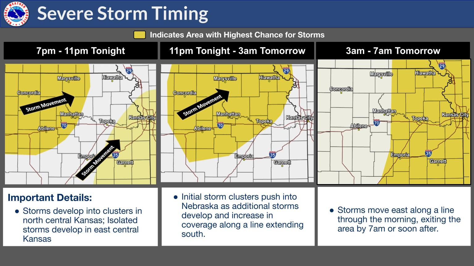
++++++++++++++++++++++++++
KS/MO/IA


MO/IA/IL/WI

+++++++++++
WI/MN/IL/IA


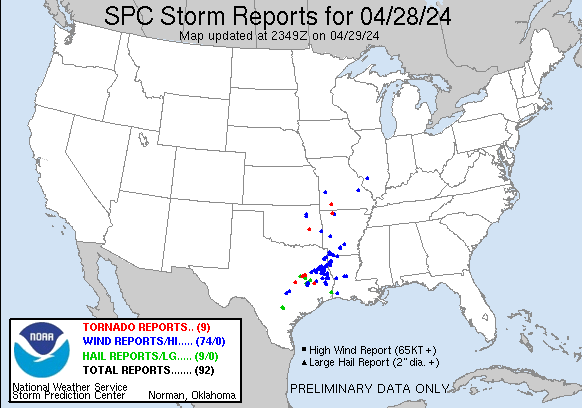
Storm reports from Saturday/Saturday Night:
https://www.spc.noaa.gov/climo/reports/yesterday.html

Friday/Friday Night below. Extremely unusual for tornadoes to be more than double the severe thunderstorm wind reports!!!!! It's likely happened before but I don't remember seeing it.
A totally freaky situation in NE/IA that led to this where almost 100 tornadoes occurred in a small region!!

Additional Storm reports for 4-28-24
A tornado forms from a large thunderstorm. Inside thunderclouds, warm, humid air rises, while cool air falls--along with rain or hail. These conditions can cause spinning air currents inside the cloud. Although the spinning currents start out horizontal, they can turn vertical and drop down from the cloud--becoming a tornado.

https://en.wikipedia.org/wiki/Tornado
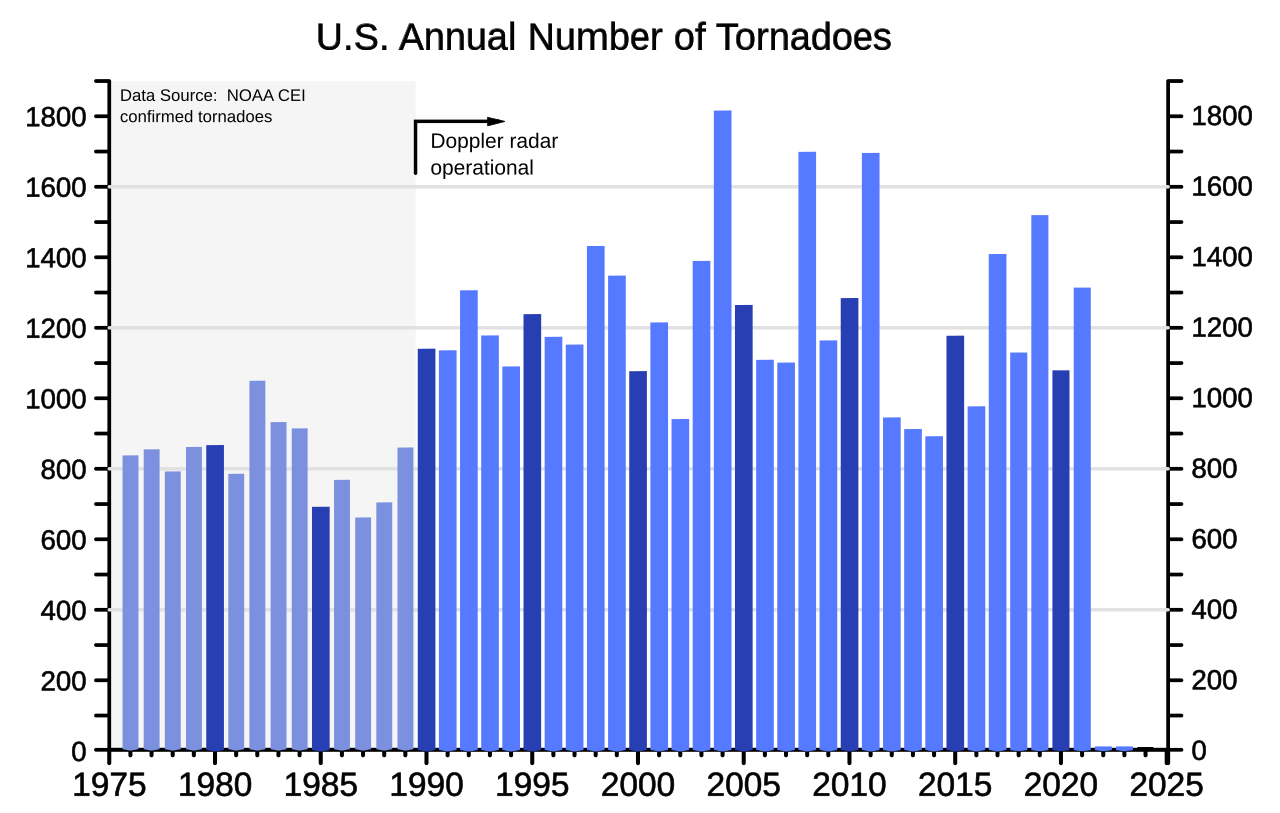
Doppler weather radar systems can detect mesocyclones within a supercell thunderstorm. This allows meteorologists to predict tornado formations throughout thunderstorms.[106]

++++++++++++++++++++++++
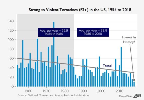
Global warming reduces the meridional temperature gradient(by warming the coldest places/higher latitudes) the most. This has cause a REDUCTION in the most violent tornadoes.
May 29th, 2019 by Roy W. Spencer, Ph. D.
https://www.drroyspencer.com/2019/05/recent-tornadoes-are-due-to-unusually-cold-weather/
+++++++++++++++++
https://inside.nssl.noaa.gov/nsslnews/2009/03/us-annual-tornado-death-tolls-1875-present/
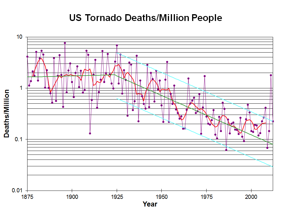
The graph above is only thru 2012.
Great Tri State Tornado 99 years ago
Started by metmike - March 18, 2024, 2:38 p.m.
https://www.marketforum.com/forum/topic/102699/
++++++++++++++++
https://en.wikipedia.org/wiki/List_of_tornadoes_causing_100_or_more_deaths
++++++++
https://gitnux.org/tornado-statistics/
++++++++++
Tornadoes come from mainly two types of thunderstorms: supercell and non-supercell.
https://www.nssl.noaa.gov/education/svrwx101/tornadoes/types/
QLCS tornadoes are associated with lines of strong thunderstorms, and frequently occur during late night and early morning hours. [+]
Why did so many strong tornadoes strike Nebraska and Iowa?
https://www.3newsnow.com/weather/weather-blog/the-science-behind-last-fridays-tornado-outbreak
https://www.youtube.com/watch?v=Ky44IKvNFjg
https://www.ketv.com/article/nebraska-tornado-video-interstate/60621455
We had more severe weather earlier today in some of the same places that got hit hard recently. Mostly large hail this time.
You can scroll down from the top to see the latest weather in this area.
https://www.marketforum.com/forum/topic/103567/