Below average because of the El Nino!
More on Friday.
https://www.noaa.gov/news-release/noaa-predicts-below-normal-2026-atlantic-hurricane-season
+++++++++++++
It's mostly based on the rapidly developing El Nino which increases the chance for downstream wind sheer aloft that tears apart tropical systems which thrive on low speed upper level winds that allow the lower level developmental processes to be less hindered as they rise to higher levels. (for the ocean, lower level and upper level to stay more coupled as opposed to the upper level connection being ripped apart from a jet stream).
In the Mid Latitudes, jet streams ENHANCE LIFT which makes weather systems even stronger as they get their energy from temperature and pressure gradients(and the Coriolis force/spin of the earth).
In the tropics, hurricanes act as massive, natural heat engines that convert thermal energy from warm ocean waters into the mechanical energy of wind. They are fueled by a continuous cycle of evaporation, condensation, and pressure. Strong upper level winds disrupt this.

Thank you very much for starting and posting in this thread!
*This post specifically addresses only the CONUS*
——————————
It only takes one to possibly be a bad year and unfortunately even some strong+ El Niño seasons (where we’re likely headed) have had bad hits on the CONUS. Keep in mind that just a TS hit or even just a TD can cause devastating freshwater floods if slow moving.
I just looked at the 13 strong+ El Niño seasons.
High impact storms in Conus during strong+ Nino (per RONI for 1950+)(2023 excluded since RONI peak only +1.49; so I didn’t count Idalia): I found 12
July 1997: H Danny (extreme rains Mobile area)
August 1991: H Bob (NC OB to E NE) though Nino not strong til later
June 1972: H Agnes in FL due to tornadoes and in PA as TS due to extreme rains though Nino not strong til later
Sept 1965: MH Betsy (one of New Orleans’ worst)
June 1957: MH Audrey (near TX/LA border) although Nino not strong til later
June 1902: TS storm #2 flooding rains TX although Nino not strong til later
July 1896: H storm #1 Pensacola though Nino not strong til later
Sept 1896: MH storm #4 NW FL and major damage well up into E US although not strong Nino til later
August 1888: MH/H storm #3 S FL/New Orleans although Nino not strong til later
Oct 1888: H storm #7 NW FL with TS winds up E coast to NE
Sept 1877: H storm #2 entire US Gulf coast
Oct 1877: MH storm #4 NW FL with TS/ET wind/rain damage well up E US
——————
- Per best tracks, all TCGs of these 12 high impact storms were W of 50W with most W of 70W.
-Only 5 of these 12 high impact Conus storms hit when Nino was already strong. So, early season could be the riskiest portion, which is pretty intuitive. Then again, MH Betsy (1965) and MH (storm #4) in 1877 hit when Nino already very strong. So, these are just good guidelines since nothing’s set in stone.
-These 12 hit during 9 of the 13 seasons that were strong+ Nino seasons. So, only 2015, 1987, 1982, and 1930 of these 13 had no Conus high impact storm. So, whereas there’s legit hope the Conus will be largely unscathed with the upcoming very strong Nino, I unfortunately wouldn’t bet against one ruining things somewhere even if isn’t a MH as was the case 7 of the 12 times.
Despite the above, the good news is that there’s a very good chance for a quieter than average season overall for the Conus. Thus, the chance of a multiple storm high impact year like 2024, 2020, 2018, 2017, 2008, 2005, 2004, 1999, 1998, 1996, and 1985 among others is lower than average despite 2 storms with high impact hits in 1896, 1888, and 1877.
Extremely fascinating, Larry!
I waited to comment because I wanted to let this sink in more.
You pretty well covered the significance with regards to what we should take away from it.
Sort of interesting that 7 of the 13 occurred between just 1877-1902. That could just be random variation rather than related to climate change. I'm not suggesting that climate change is reducing major hurricanes because warmer oceans can increase rapid intensification... the opposite. Just that maybe a warmer tropical Pacific and El Nino might have increased wind shear MORE than they did before the global warming of around 2 deg. F.
That's wild speculation. More importantly, its easy to forget how poor the technology, tracking and records are for the era.
Added: As you've done, you're comparing apples to apples which is LAND FALLING hurricanes because we were completely blind to most of the oceans during those past years before acquiring good detecting technology. Something like 30-40% of Atlantic hurricanes make landfall. That means the majority curve north and east of the US and Caribbean. There had to be some major hurricanes out to sea that we could never possibly have data on.
Until we started with Hurricane Hunters ( I actually joined the National Hurricane Center meteorologists, flying into Hurricane Gloria in September 1985) we had very little idea of what was going on over the vast oceans.
The Satellite era is when we really got the biggest boost in information!!
Hurricane Hunting started on a dare in the middle of World War II, when Lt Col Joe Duckworth took an AT-6 Texan training aircraft into the eye of a hurricane. Our squadron traces its heritage back over 50 years, to the 3rd Weather Reconnaissance Squadron, Air Route, Medium on August 7, 1944.
++++++++++++++++++=
https://en.wikipedia.org/wiki/Hurricane_hunters
+++++++++++++++++++++++
++++++++++++++++++++++
https://airandspace.si.edu/stories/editorial/how-satellites-track-storms-space
++++++++++++++++++
By metmike - June 30, 2023, 1:51 p.m.
++++++++++++
Some great posts on nature and conversation with Jean also at that thread!!
My ‘26 season Atlantic tropics prediction:
8/4/1 and ACE of 52
Anyone else?
Also, EPS has nearly 50% of its members with a TCG in S Gulf/NW Car late next week with most of those then heading to the U.S. Gulf coast the following week.
Hey, wxfollower! Are you the Larrywx who posts at Storm2k?
I'm strictly a reader there. Too many people who seem to know what they're talking about, they don't need my silliness.
Hey Patrick,
Yes I am. All are welcomed to post regardless of knowledge level. I wouldn’t sweat it, especially if you want to post occasionally to mainly ask questions, a great way to learn from the answers. You can still post “smartly”, especially if you don’t overdo it. But of course sticking to reading, which numerous folks do, is fine, too. Way more people read w/o posting than those who post at most boards.
Cool!
I already post too much. Mostly about newspaper comics and the state of the world.
Been posting as Downpuppy for 25 or so years. Haven't got into major trouble. Yet.
 David Schlotthauer@Weatherunited1
Well, looks like CSU is trending much lower to my hurricane seasonal forecast. I'm predicting 5-8 named storms, 1-3 hurricanes, and 1-2 major hurricanes. With my forecast ACE at 45-60
CSU reduces forecast for 2026 Atlantic #hurricane season and now calls for well below-normal activity: 9 named storms, 4 hurricanes & 1 major hurricane. High likelihood of strong #ElNino and associated increase in vertical wind shear the primary factor: https://tropical.colostate.edu/Forecast/2026-07.pdf
Experts at Colorado State University led by
just lowered their predictions for the Atlantic hurricane season for the second time this year. If their forecast pans out, it would be one of the least active seasons in 30 years. More https://michaelrlowry.substack.com/p/forecasters-
Wind shear in the bellwether Caribbean so far this July resembles the type of shear we'd see in mid December, not mid July. Almost 60 knots of shear averaged through the Craibbean yesterday. Good luck getting tropical development out of the deep tropics with that!
Gulf TD appears to be imminent as the 0Z Euro had it as a borderline TS and the UKMET has had it as a TS for 5 full runs:
Tropical Weather Outlook
NWS National Hurricane Center Miami FL
800 AM EDT Sun Jul 19 2026
For the North Atlantic...Caribbean Sea and the Gulf of America:
Northern Gulf of America and near Florida (AL91):
An area of low pressure located over the northeastern Gulf of
America continues to become better defined and the associated shower
and thunderstorm activity is gradually increasing. Continued
gradual development is expected, and a tropical depression is likely
to form later today or on Monday as the system moves slowly
northward or northwestward. Interests along the northern Gulf coast
from Florida, Alabama, Mississippi, and Louisiana should monitor
the progress of this system, as tropical storm watches or warnings
could be required for portions of the area later today. In
addition, this system is expected to bring heavy rains to portions
of the northern Gulf coast during the next several days. An Air
Force Reserve reconnaissance aircraft is scheduled to investigate
the low pressure area later today.
* Formation chance through 48 hours...high...80 percent.
* Formation chance through 7 days...high...80 percent.
$$
Forecaster Cangialosi
Thanks very much, Larry!
Will Bertha be Birth soon? Sound Here’s the #science behind the forecast challenge! For days it seemed the jet stream may tug and shear the system north into land before development. But now it seems it will be left behind, sitting in the hot Northern #Gulf for enough time to
https://x.com/WeatherProf/status/2078829483247956416/video/1
+++++++++++
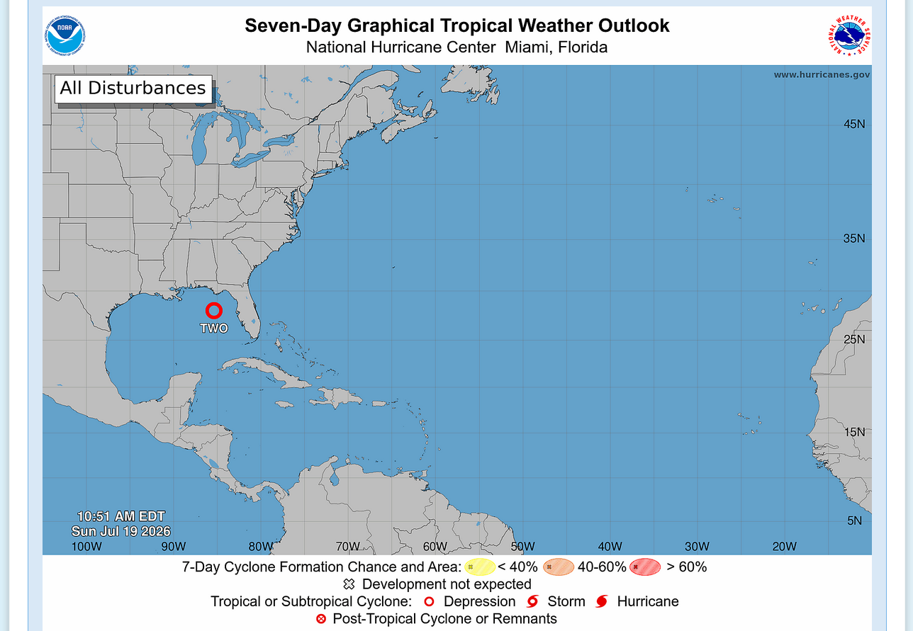
It’s now TS Bertha:
Tropical Storm Bertha Advisory Number 7
NWS National Hurricane Center Miami FL AL022026
1000 PM CDT Mon Jul 20 2026
...TROPICAL STORM WARNING ISSUED FOR A PORTION OF THE NORTHERN
GULF COAST...
SUMMARY OF 1000 PM CDT...0300 UTC...INFORMATION
-----------------------------------------------
LOCATION...28.2N 85.9W
ABOUT 140 MI...225 KM S OF PANAMA CITY FLORIDA
ABOUT 215 MI...350 KM SE OF MOBILE ALABAMA
MAXIMUM SUSTAINED WINDS...40 MPH...65 KM/H
PRESENT MOVEMENT...STATIONARY
MINIMUM CENTRAL PRESSURE...999 MB...29.50 INCHES
FORECAST POSITIONS AND MAX WINDS
INIT 21/0300Z 28.2N 85.9W 35 KT 40 MPH
12H 21/1200Z 28.8N 86.6W 40 KT 45 MPH
24H 22/0000Z 29.1N 87.3W 45 KT 50 MPH
36H 22/1200Z 29.3N 88.1W 45 KT 50 MPH
48H 23/0000Z 29.3N 89.4W 40 KT 45 MPH...INLAND
60H 23/1200Z 29.3N 90.7W 35 KT 40 MPH...INLAND
72H 24/0000Z 29.3N 92.1W 30 KT 35 MPH...OVER WATER
96H 25/0000Z 29.3N 94.6W 25 KT 30 MPH...OVER WATER
120H 26/0000Z 29.3N 97.0W 20 KT 25 MPH...POST-TROPICAL
$$
Forecaster Pasch
Thanks, Larry!
Temperatures are very warm in the Gulf right now, but hurricanes need more than just warm water. The wind shear right now (winds changing with height) is preventing this storm. Tropical systems generate energy from rapidly rising air parcels that maintain an almost straight up trajectory, above their surface origin. Winds that veer/change with height will cause those parcels to deviate from straight up.
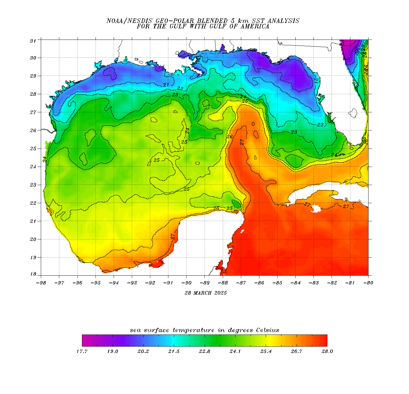
The 30 deg. C isotherm below is 86+ deg. F everywhere inside of that. We need ~79 deg. F for a tropical storm. All things equal, when conditions are near perfect, the warmer the water, the better the opportunity for rapid intensification.
Wind sheer like we have now defeats the heat machine dynamic described above. The current El Nino is greatly contributing to the wind shear and is the reason for Hurricane forecasts in the Atlantic Basin to have BELOW average activity, despite plenty of very warm water.
https://www.ospo.noaa.gov/products/ocean/sst/contour/#ocean-27
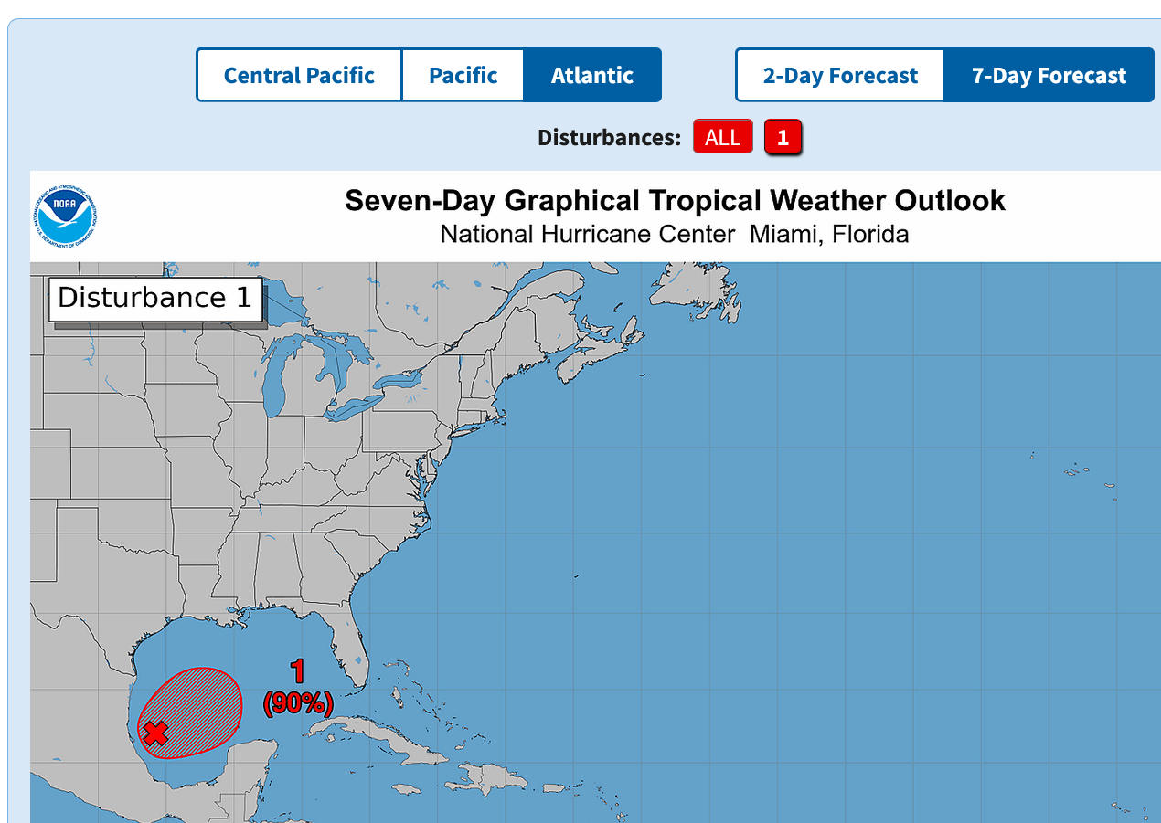
The models are making some noise suggesting the possibility of a TD forming in the SW Gulf later this week. NHC has a 20% chance of genesis
Thanks very much, Larry!
I'm especially glad that you pulled up this thread from earlier in the Summer to give us that very early perspective............before morphing into the weakest hurricane season in a century that none of us anticipated!
Hurricanes in the Pacific +Atlantic Basin-record low!
13 responses |
Started by metmike - Sept. 7, 2026, 4:57 p.m.
https://www.marketforum.com/forum/topic/122634/
++++++++++++
Either thread is fine to use or, if we finally get a hurricane in the Atlantic, starting a new thread or if something else about hurricanes that doesn't fit OR if the thread is getting too long(which happens a lot because I very much like having the entire discussion on 1 thread as long as possible for people reading it for the first time vs starting a new thread from scratch with a link to the old one)
++++++++++
Your analysis here, also deserved to be repeated for great perspective! The hurricane season is not over yet.
Regardless, this will be 1 for the record books and extremely valuable for us to learn things about something that has never happened before.
When things have happened 10+ times before, we have useful analogs and a well defined range at the extreme ends(that defines expectations). Each year is different though.
When it's unprecedented like right now, we have more speculation than usual to go with the science. Along with that comes speculation for something that never happened before but with extreme uncertainty of the path that will take.
Re: 2026 Atlantic Hurricane Forecast
By WxFollower - May 31, 2026, 2:34 p.m.
+++++++
I really enjoyed reading that post again this morning!
Thanks, Mike.
The potential is growing rapidly as it looks almost certain that a TD will form soon. A hurricane coming out of this is quite possible as of now. Oil and NG traders take note:
Tropical Weather Outlook
NWS National Hurricane Center Miami FL
800 PM EDT Mon Oct 5 2026

For the North Atlantic...Caribbean Sea and the Gulf of America:

1. Southwestern Gulf of America (AL92):
A trough of low pressure over the southwestern Gulf of America is
producing disorganized showers and thunderstorms. Although
environmental conditions appear to be only marginally conducive,
gradual development is becoming more likely, and a tropical
depression is expected to form during the middle portion of the
week. This system is expected to drift east-northeastward over the
next couple of days, before it turns northward.  It is too early to
determine the specific impacts to the northern Gulf Coast, but
interests there should closely monitor the progress of this system.
* Formation chance through 48 hours...high...70 percent.
* Formation chance through 7 days...high...80 percent.


Forecaster Pasch
Thanks very much, Larry!
Who would have thought a storm like this would get so much attention?
Answer: When it's October and there still hasn't been a hurricane yet in the Atlantic basin!!!
++++++++++++++++++=
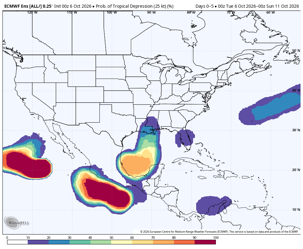
This is from the last 0z European Ensemble model. Odds of this becoming a depression are high but development beyond that, to become our first hurricane appear pretty low.
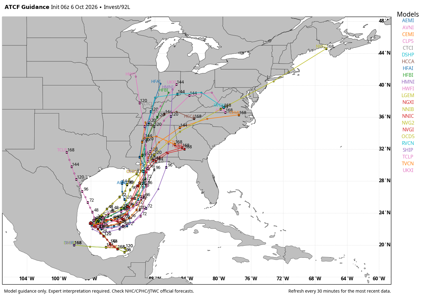
Below includes the tracks of any remnants. I sure hope the unlikely northern tracks happen to bring needed rains here in southwest IN!!!
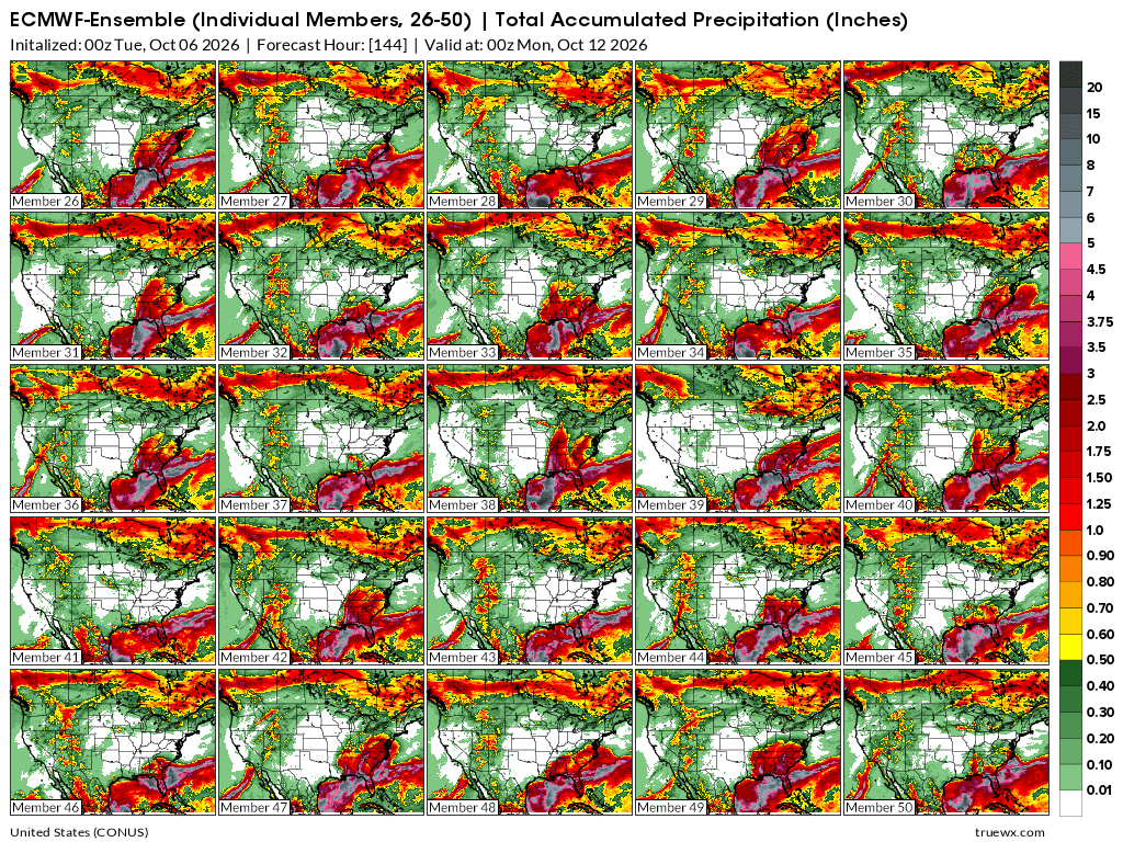
Total rains thru Sunday from the last 0z European Ensembles individual members. Remnants of this system could load that atmosphere.
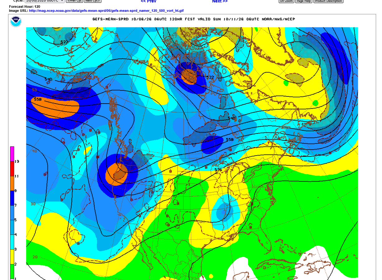
This was the last 500 mb solution of the last 6z GEFS. This is the ensemble MEAN (average) of ALL the ensembles. The blue colors(centered just northwest of Memphis, TN are a reflection of numerous members capturing the remnants in their solution and transporting them northward.
This is around 18,000 feet above the ground in the atmosphere which is around the midpoint of the atmosphere based on it's weight/mass. The air becomes lighter and lighter(less dense) the higher up we go.
So the bottom half, distance-wise might be 18,000 feet but the top half is many times that in actual distance because the air is so much lighter.
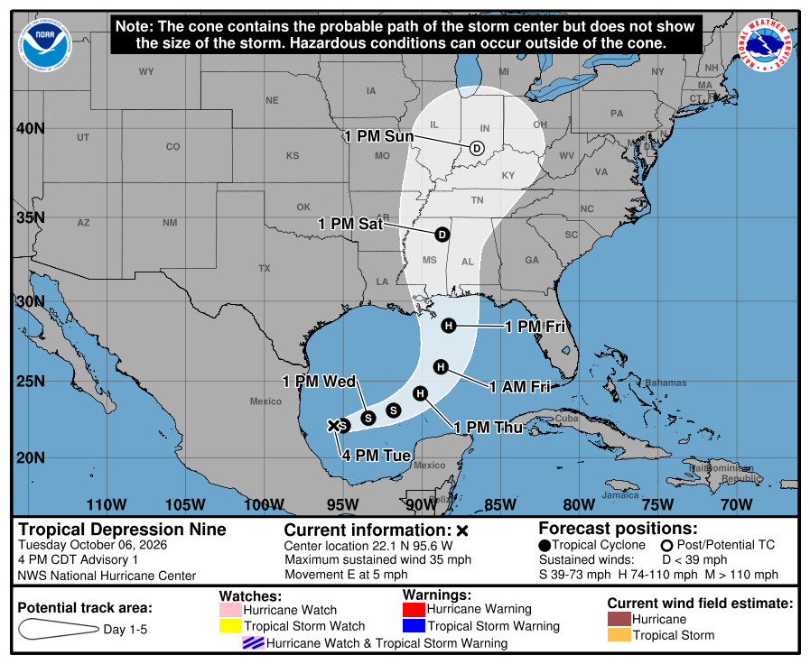
Thanks, Mike! This is now TD9: