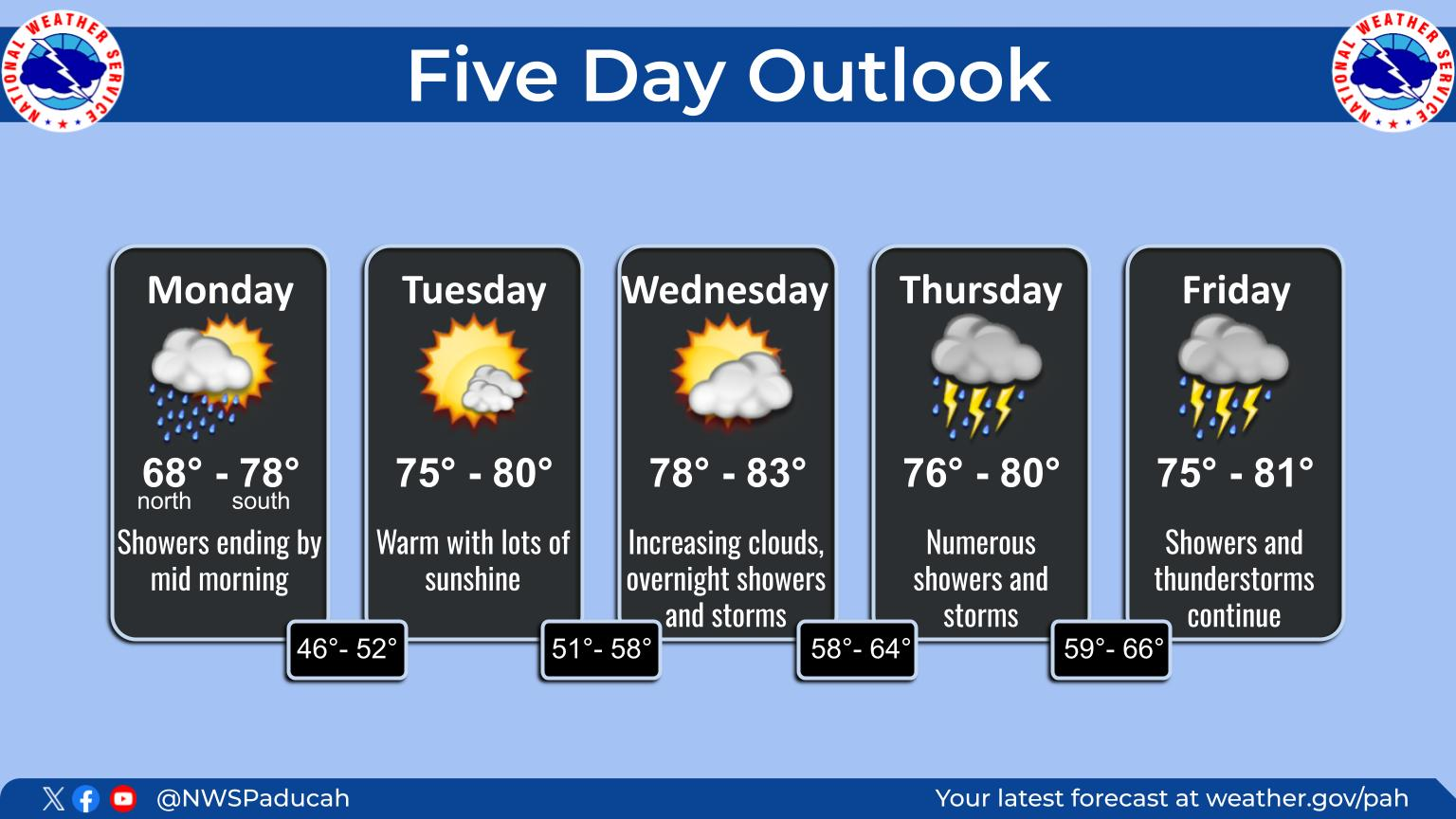
 Weather Map
Get all the comprehensive weather here:
https://www.marketforum.com/forum/topic/83844/
+++++++++++++
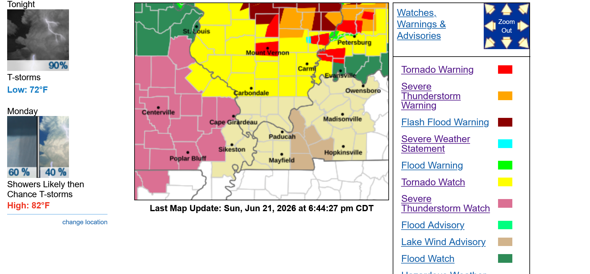
Since it's getting pretty stormy in the Evansville area, I started a new thread.
The map below has around 10 colors on it!!!!
I did a freeze frame to save it too. 2nd image. All the action is just north of Evansville, barely and moving due east. 1st image should be updating constantly.
Current Hazards at the link below.
For your NWS and county, go to the link below.
Then you can hit any spot on the map, including where you live and it will go to that NWS with all the comprehensive local weather information for that/your county.

New radar product below
Go to: "Select View" then "Local Radar"
Hit the purple circle to see that local radar site
+++++++++++++++++++++++
This link below provides some great data. After going to the link, hit "Mesoanalysis" then, the center of any box for the area that you want, then go to observation on the far left, then surface observations to get constantly updated surface observations or hit another of the dozens of choices.

Updated mesoscale discussion from the Storm Prediction Center.
Several tornadoes ARE happening right now in this area.
Tornado winds up to 125 mph. Not a violent tornado but still very dangerous and we need to go to our safe place if one of these tornadoes is headed towards your neighborhood.
Staying 1 county north of Evansville right now.
https://www.spc.noaa.gov/products/md/md1237.html

Always a great idea to have your electronics charged up in case of losing power.
Storms still staying north of Evansville.
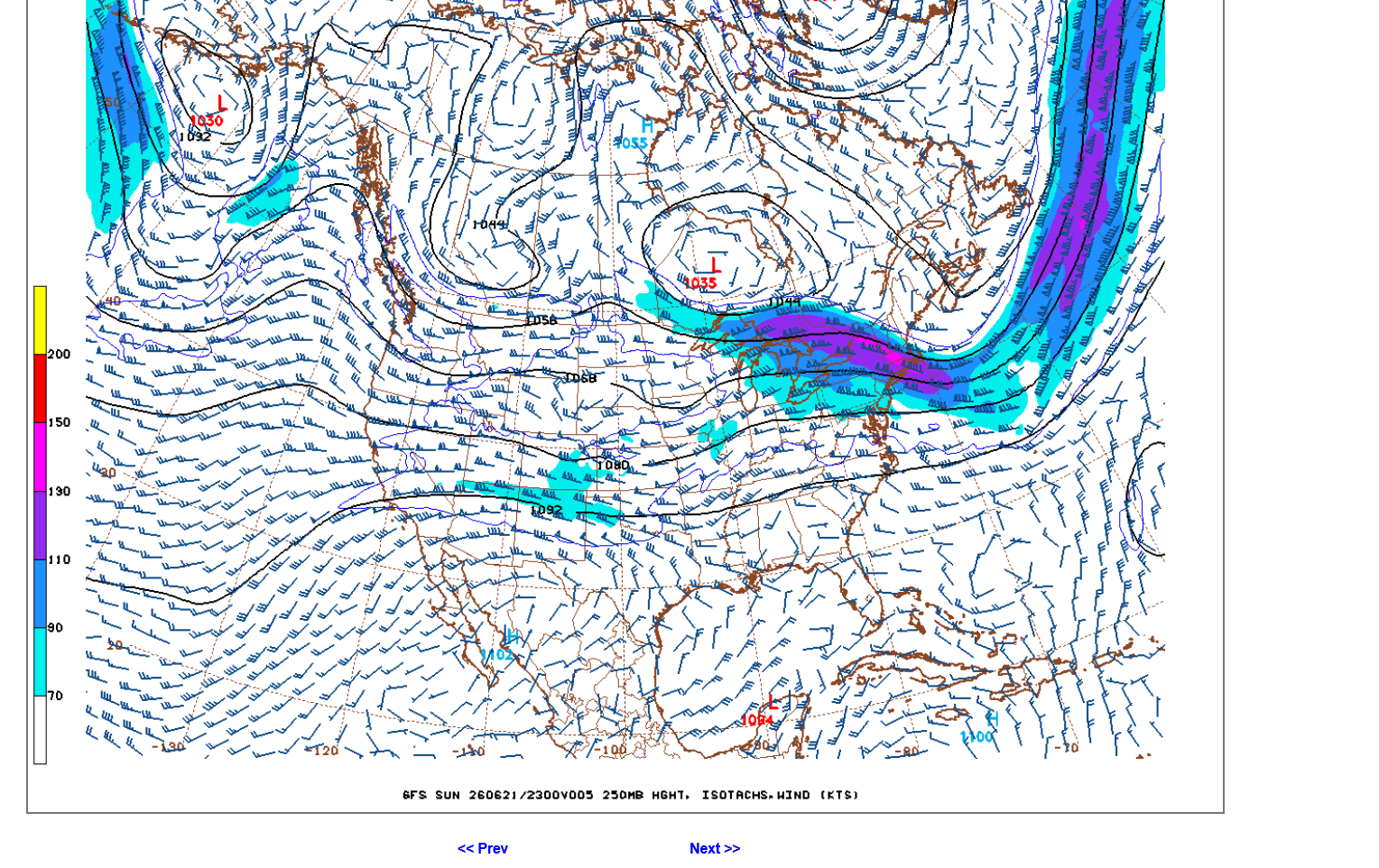
The amount of tornadic activity has been shocking considering there was only a slight risk of severe weather today and the jet stream below is not very impressive!!!
This is the jet stream at just above 30,000 feet.
Winds UNDER 100 mph right now. I can't remember a tornado outbreak without a jet stream MUCH stronger than this.
30 tornadoes so far today, most of them in southern IL/IN. Almost as many as severe thunderstorms.
I can't ever remember that happening! More tornadoes, sure but not normally we see 5-10 times the number of high winds as tornadoes.
https://www.spc.noaa.gov/climo/reports/today.html

Sirens going off for Vanderburgh County for a storm that is northeast of Evansville and no threat for us on the north side.
9:04 pm OK, brand NEW warning for V county for a strong storm but likely not tornadic that will impact areas east of 41 North.
Not worried about this one!!!
9:14 pm: That storm is east of us!
To see how much rain fell at your house the last 24 hours or any other place in the country, go here. Scroll to any place in the country or put your zip code in.
It's updated within minutes of the rainfall. I think it uses NWS automated rain gauges that are are numerous in every county.
9: 40pm New tornado warning with the far southern part of it impacting the far north side of Evansville until 10:30 pm.
No tornadoes reported with this storm yet.
Potentially dangerous storm but it doesn't look too dangerous to me.
New severe thunderstorm warning out for the eastern part of V county to Warrick County. Not to worry for folks except along the Warrick County line and Warrick County.
I've been doing this professionally as a meteorologist since 1982. In the 1980's/early 1990's, we didn't have nearly the data, technology and outlooks so I won't compare yesterday's tornado outbreak to those years.
However, this tornado outbreak was the biggest surprise since the mid 1990's!
Even with the 1980's tornado outbreaks, we had powerful, well measured jet streams ahead of time that gave us a strong clue.
Yesterday, however we had very localized tornado outbreak WITHOUT a strong jet stream. Clearly, there was something unique that greatly amplified the spin and rotation of the air in these strong thunderstorms that spawned dozens of tornadoes in a very small area, seen below.
Part of this extreme anomaly is the fact that we had almost as many tornadoes-red as we did to severe thunderstorm winds-blue and NO hail-green.
That NEVER happens! The pattern for severe weather in the Plains yesterday was more typical. 5-10 times more severe storm winds than tornadoes.
Maybe this happened before in a far away state and I wasn't paying attention to it that day???
Regardless, because this happened where we live and I was following it closely yesterday(even earlier in the day when I was convinced it wouldn't be that bad), like I've been doing with our weather since 1982(after being hired as the chief meteorologist for WEHT-TV in Evansville, IN), I can say with absolute confidence that the tornado outbreak of Fathers Day 2026, June 21st is the most unique of the last 44 years.
Stronger tornadoes in this area in the past? Yes
This many tornadoes in a tightly clustered pattern with a very weak jet stream and not that many severe thunderstorms?
NEVER!!! Not even close!!!
