Cotton up sharply today because of Michael.
These links have weather/hurricane info that will effect cotton:
https://www.marketforum.com/forum/topic/14678/
Hurricane Michael:
There is a threat to the cotton crop from heavy rains produced by Michael. Nothing like Florence probably more like 8 inches and mostly in S.Georgia....a high production area.
However, there is also the threat of wind damage.
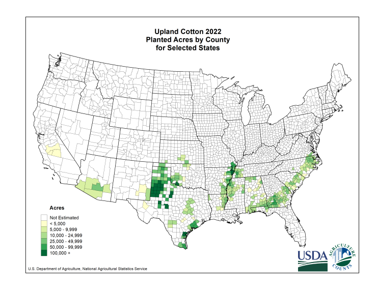
Below is a map of where cotton is grown and below that are the total rains for the next 7 days.
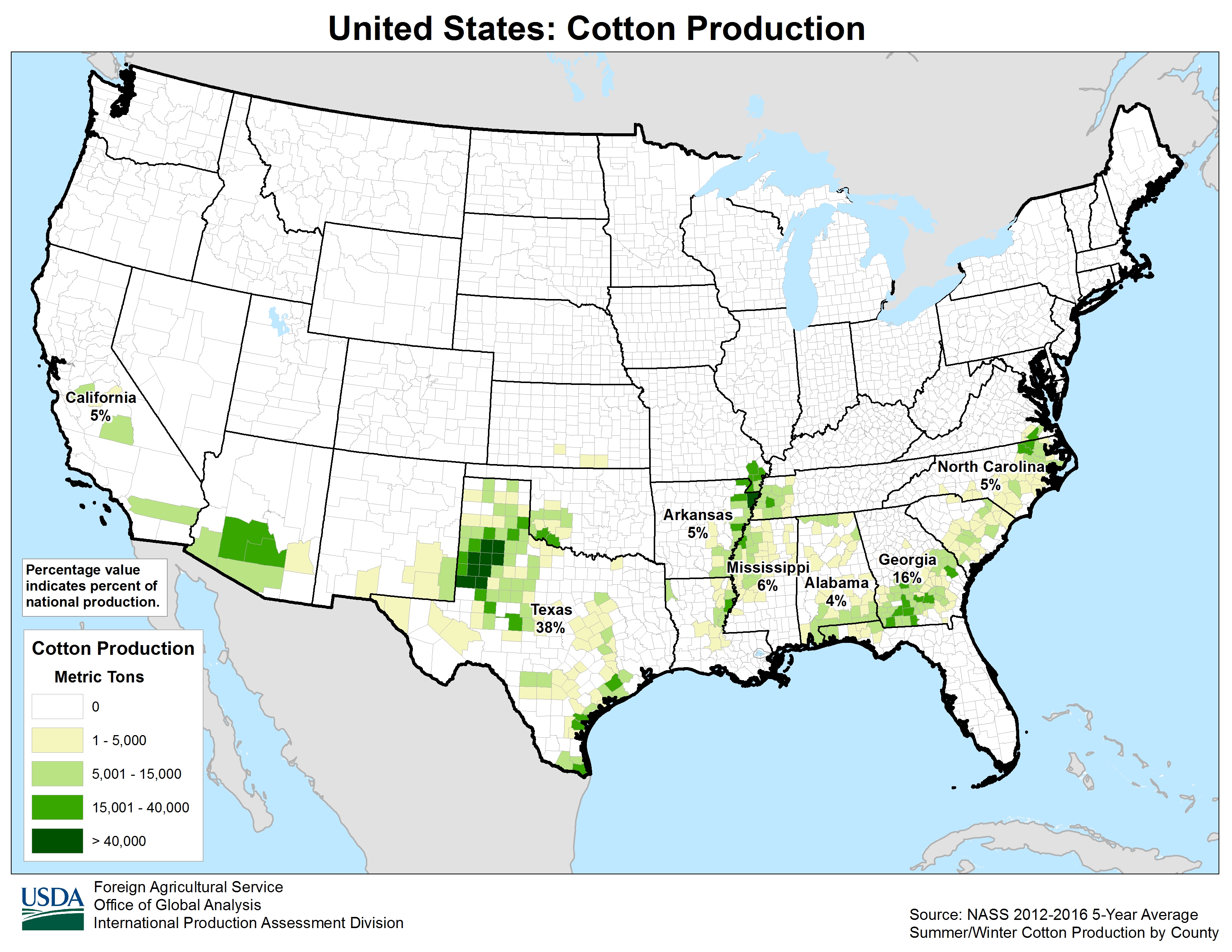
Here is another production map for cotton. This one shows the % production by state. The state at most risk is Georgia which produces a whopping 16% of the cotton crop, 2nd to only Texas.
Historical price perspective on cotton. Charts below.
3 month-major top in June!!
| |
| |
| |
| |
Mike,
Not to trivialize the GA crop, which is 2nd largest of any state, but isn't the rather heavy rain falling today and again tomorrow over NW TX potentially as much of a factor? There's not the widespread wind threat there that GA has and probably not as heavy rain overall, but it is widespread rain and potential acreage affected is much larger...what, twice as large? I wasn't sure whether or not you overlooked the TX rains.
From WSJ news: "Texas appears to be receiving some unwanted rain. Currently a front is
producing widespread rains from southern West Texas, up into Oklahoma and
beyond."
Edit: Furthermore, there are additional significant rains forecasted this weekend. This can't be good for harvest there.
Actually, I did overlook those rains, so thanks for reminding me/bringing it up. Mainly because it looks like LESS rain there from the current system than was in the forecast last week.......and the heavier rains will be northeast of cotton country.
As you mentioned though, there will be more rains there this weekend but those rains don't look especially heavy, though they are unwanted and come at a bad time of year.
Current radar below.

Go to: Most Recent Image
7 day total rains from NWS forecast below:

10 day rains from 12z GFS below

... wishin' I still had the phone number for my favorite cotton customer, first and hardest job on the cotton pit floor 89'.... Trip O. Lee .... man that guy was a piss ripper...
..." Michael " Jordan Cotton Hanes Ready For The BUY" Dec - Red Dec Spread " ...
.....Slamma Jamma Ding Dong,,,, AND GO TO BED
Mike,
There's actually a second batch of widespread rain now falling over prime TX cotton. It shows on that radar you posted since it is updated to reflect the present. Did you expect this 2nd batch? Then as we both know H Sergio's remnants may lead to more widespread rains this weekend.
Just travelled through north Alabama, west Tennessee, and Arkansas last week. Most cotton fields were done and begging to be picked. A few were still green, and not yet ready. It seemed to be a strange conflict that may have been caused by rain during the planting times. But overall, most of the cotton should have been out of the field by now.
The threat to cotton is not much different today but Michael will be moving fast enough so that the heavy rains will be brief.
Winds will be an issue to S. Georgia but I don't know enough about cotton to guess on what sort of winds are needed for major damage.
Mike said: "Winds will be an issue to S. Georgia but I don't know enough about cotton to guess on what sort of winds are needed for major damage. "
----------------------------------------------------------------------
Irma had 40 mph sustained with gusts to 50 mph and that was enough to do significant damage of apparently 20%+ in many areas of GA from what I've read. Elsewhere I read something that suggested that 50 mph winds can easily cause 50%+ damage. The rare instances of hurricane force (~75 mph) have been enough to cause near 100% damage. We're facing a much stronger wind threat than Irma, which was already downgraded to a TS once it entered GA. Michael could easily produce 75ish+ mph for highest winds in much of the heart of cotton country in SW GA. Furthermore, open bolls are ~90% with only a small part harvested vs a much smaller 51% during Irma. And this isn't even taking into account 4-8" of rains. Translation: this is likely going to mean major damage in GA as well as in SE AL and NW FL. I don't think I could draw a more potentially devastating path than the current NHC forecast. I'd like to do some more research but the potential loss of the GA and SE AL crops is likely as high as from any other storm of at least the last few decades.
I had said: "Irma had 40 mph sustained with gusts to 50 mph and that was enough to do significant damage of apparently 20%+ in many areas of GA from what I've read."
and
"I don't think I could draw a more potentially devastating path than the current NHC forecast. I'd like to do some more research but the potential loss of the GA and SE AL crops is likely as high as from any other storm of at least the last few decades."
--------------------------------------------------------------------------------------------
I looked at the USDA report before Irma for GA and compared it to the final number for GA. Its crop dropped from 2.7 MB to 2.3 MB or a drop of 15% due pretty much all to Irma. this was from just 40 mph sustained/gusts to 50 and was when bolls were only 51% open:
In contrast, we have a cat 3+ that will very likely still be a cat 1 H in at least far SW GA with high end TS winds of 55-70 likely well into GA along the path afterward. Also, bolls are 88% open. Translation: a much higher than 15% loss is liable to occur...perhaps 33% or more of the 2.8 MB crop meaning 1 MB could very well be at risk. And that's not including SE AL/NWFL, which have ~0.4MB bales crop right now.
When was the last time a storm, before CT harvest, anywhere near this strength took this kind of track from FL through SW GA? Believe it or not, way back in 1894 (storm #5 in October):
http://weather.unisys.com/sites/default/files/mnt/webdata/hurricane/atlantic/1894/5/track.gif
Kate of 1985 was almost as strong but this was in late November or way after harvest:
http://weather.unisys.com/sites/default/files/mnt/webdata/hurricane/atlantic/1985/KATE/track.gif
#7 of 1898 came from the Atlantic side and did a lot of CT damage per what I've read: http://dublinlaurenscountygeorgia.blogspot.com/2016/10/hurricanes-in-middle-georgia.html
http://weather.unisys.com/sites/default/files/mnt/webdata/hurricane/atlantic/1898/7/track.gif
#4 of 1877 also had a similar path to Michael's forecast/strength:
http://weather.unisys.com/sites/default/files/mnt/webdata/hurricane/atlantic/1877/4/track.gif
#5 of 1852 also had a similar path to Michael's forecast though it wasn't nearly as strong in the Gulf:
http://weather.unisys.com/sites/default/files/mnt/webdata/hurricane/atlantic/1852/5/track.gif
#4 of 1851 had a similar path to Michael's forecast/strength though it likely occurred well before most bolls would have been open:
http://weather.unisys.com/sites/default/files/mnt/webdata/hurricane/atlantic/1851/4/track.gif
---------------------------------------------------------------------------------------------------------
In summary, Michael has a good chance to be the most damaging by a large margin to GA CT in percentage terms since 1898.
Wow Larry, Great work!
I'm wondering why the market is not paying more attention to this. Maybe the USDA report out tomorrow?
The right side of the hurricane, when it goes thru GA with a speed of maybe 15-20 mph is going to have the speed of the entity added to the speed of the winds circulating around it on the right side.
GA only has 12% of the crop harvested:
http://usda.mannlib.cornell.edu/usda/current/CropProg/CropProg-10-09-2018.txt
Mike, thanks.
Yeah, CT mkt is obviously not worried about Michael at least yet despite it being one of the strongest hurricanes on record and it threatening such a large part of the SE US crop. Perhaps, although it is a futures market, it is waiting for the damage to occur first and then assess. Also, as you implied, perhaps it is expecting a bearish USDA tomorrow.
I just looked at projected highest wind gusts for S GA, SE AL, and NW FL. I conservatively estimate that 0.75 MB would be affected by hurricane force gusts. Based on history, the vast majority of that CT would likely be damaged or even destroyed if those winds verify. I’ll conservatively call it 75%. The remainder of the 2.5 MB for the 3 states are projected to get tropical storm force gusts as high as 70 mph. Conservatively, 25% of that could be lost. Adding that up gives me potential losses of 1.2 MB and that’s being conservative. And I’m not even taking into account possible additional damage from heavy rain. Also, I’m not even taking into account possible losses in the Carolinas and VA.
So, it appears to me that the SE US crop has a good chance for 1MB+ being lost (or 5%+ of the US crop) from Michael and that’s being conservative. In looking back at past hurricanes, I don’t know that I can find a single hurricane doing anywhere near that much damage to the US crop in recent decades largely because there hasn’t been anything even close to this potential level impact on the GA crop since 1898 and because the GA crop is so large this year. Usually hurricanes are more of a scare than reality as far as big losses are concerned. Michael appears to be a different animal.
Based upon cycle analysist, cotton 'should' have put in a daily and weekly low October 1, 24 days from its last daily cycle and 26 weeks from its previous weekly cycle.
IF the cycle is confirmed. one would expect multiple weeks of higher highs before a weekly crest is formed.
The December contract has a recent 20 point range, 95 to 75. Looking at the chart, there are 'old' lows in the 81.25 area or roughly the 32 fib. Half way back is 85.
Cycle work suggests long positions into this report as the technical precedes the NEWS. Oh, less I omit, RSI 32 with multiple %R buys.
Based on reports I've been watching tonight, the worst fears for SW GA are already being realized in many areas. It is likely that these are the worst widespread winds in SW GA since the 1800s. There are definitely going to end up being very big CT losses (I'm educatedly guessing 1 MB++ from GA, alone, but we'll see). Numerous trees are down. Power outages are widespread and increasing per this:
http://outagemap.georgiapower.com/external/default.html
The NHC STILL had Michael as a 90 mph hurricane as of 8 PM EDT just WSW of Albany, which is over 100 miles inland from the Gulf!
Flash flood warnings are out in and near Albany for 3-4" that has already fallen.
Here are the last 2 hourly reports from Albany (7 and 8 PM EDT):
ALBANY HVY RAIN 78 75 90 E51G69 29.02F
ALBANY HVY RAIN 77 75 93 E51G70 28.96F
Thanks Larry,
Those are some strong winds but much lower than they should be if you go by the NHC.
Am not believing the sustained winds the NHC has been giving us.........at least the past day.
Since the hurricane has come ashore, all the reporting station winds have been a great deal lower that the NHC.
Their last report was 90mph sustained. I believe the criteria is that the wind must stay at that level for 1 minute. I can't find a station that even has a gust anywhere close to that and since the hurricane is tracking northeast at 17 mph, that would be adding to the wind on the right side.
We should be getting some gusts to 100 mph if that NHC wind was accurate.
Thanks tj!
The cotton market finally paid attention to the damage which likely occurred in GA over 24 hours ago.
A bit odd that it would take so long to react. Maybe the stock market plunge and crude falling kept it down.
Prices opened a tad higher yesterday evening and climbed to a high of 78.88 at 8am............still holding most of those gains late this morning.
Thanks Mike and tj. It looks really bleak for SW GA, far SE AL, and NW FL CT farmers. Also, while not as bad, south central GA still had lots lost or damaged. All told, I’m still educatedly guessing 1 MB+ lost in just those 3 states though we’ll have to wait. The market was up sharply on big losses although I doubt it is yet guessing losses that high as that would be pretty historic from just one storm and the worst by far for SW GA since at least 1898.
Also, though nothing like S GA and nearby, I suspect NE NC had nontrivial losses late yesterday. Keep in mind that a lot fewer bolls were open when Florence did its damage and also that further SE NC was likely more affected by her than NE NC and SE VA on a % basis since SE NC had much heavier rain and stronger winds from Florence. TS Michael was still rather potent as it was exiting NE NC and SE VA late yesterday. It wouldn’t be shocking if they lost 100K or so bales.