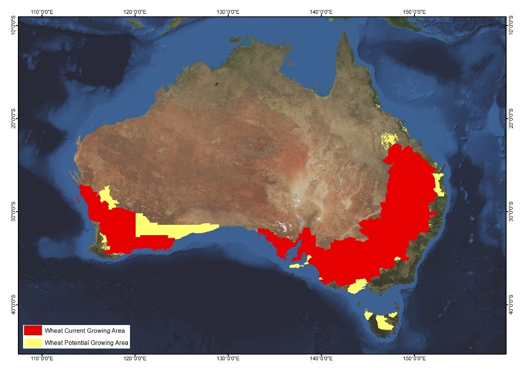
Wheat
2 responses | 0 likes
Started by metmike - April 4, 2019, 3:42 p.m.

The drought in Australia was helped by recent rains in the East but is worse in the West.


https://www.cpc.ncep.noaa.gov/products/Precip_Monitoring/Figures/global/n.30day.figb.gif


https://www.cpc.ncep.noaa.gov/products/Precip_Monitoring/Figures/global/n.90day.figb.gif

Comments
Re: Wheat
0 likes
By metmike - April 4, 2019, 3:44 p.m.
Like Reply

Australia,  is a big global supplier of wheat. This is where they produce wheat.........in the southwest and southeast/east, where there is the most rain. Fortunately, so far the driest areas have been north of wheat country in Australia:


It's getting close to being the time for them to plant their wheat in the Southern Hemisphere and they will need more rains for proper germination and early establishment. Ideal planting time begins in April and ends in early June.............so there is time to alleviate the drought conditions.

https://www.usda.gov/oce/weather/pubs/Other/MWCACP/Graphs/aus/AusWheat.pdf


https://www.agrifutures.com.au/farm-diversity/wheat/


Production status

The main producing areas are in Western Australia, New South Wales, South Australia, Victoria and Queensland.

The Australian Bureau of Agricultural and Resource Economics and Sciences reports production area for the states as follows:

  • Western Australia – 5 million hectares
  • New South Wales – 3.1 million hectares
  • South Australia – 1.9 million hectares
  • Victoria – 1.5 million hectares
  • Queensland – 610 thousand hectares
  • Tasmania – 7 thousand hectares
  - image


Image result for australia wheat  maps

Re: Re: Wheat
0 likes
By metmike - April 4, 2019, 3:46 p.m.
Like Reply


Here are the latest 2 week rain forecasts. Drying out in the eastern parts of wheat country............but some needed rain in the west. HOT almost everywhere!!!

gfs_spac_372_precip_ptot.gif


http://wxmaps.org/outlooks.php


Select a Parameter:    

Select a Parameter: