Mike, do you have anything to share about the potential for early frost this fall ?
Much of this year’s crop production will be dependent on the frost date.
I agree that the latest planted crop in history will be at risk for an early freeze. Damaging freezes happen around once every 20 years, so 5% chance on average.
The areas that always get the first frost/freeze are in the Upper Midwest and planting delays up there were not that severe. The Eastern Cornbelt usually has their first freeze something like 10 days later.........just from guessing. I'll look up the stats. It's the ECB crop thats getting in latest and southern cornbelt, where the rains were heaviest.
So this years crop is more vulnerable to a freeze but the locations most behind help offset some of that. Those areas south will also accumulate more growing units/heating degree days.
If we have a very cool Summer, that will put the corn behind even more. Heat can help catch things up.
Beans will not catch up, regardless of the weather.
I will have a first guess of a 10% chance of a damaging freeze, double the historical average.
Another item. If soils stay wet, it lessens the chance for a freeze as air masses traveling over wet soils can have dew points be 5 to even 10 degrees higher than an air mass from the same origin in N.Canada that travels over bone dry soils(like we had in 1995 that gave us the last widespread damaging freeze in mid Sept after very late planting).
The Summer was pretty hot and helped the corn to catch up but the early freeze took 200 mil bushes off the bean crop, which was alot back then. Temps got into the mid 20s all the way down to S. IL where the beans were all still very green..........same here in sw. IN.
2 mornings in a row, the NWS station 5 miles south reported a low of 39 but the water in my hose outside was completely frozen. Outlying areas were 15 degrees colder!
It was that dry air over bone dry soils(that Summer was very dry after the wet Spring). Also, the NWS instruments are 5 feet above the ground. Clear skies, calm wind and dry air can radiate heat fast and temps can be 10+ degrees colder near the ground and especially in low lying areas vs 5 feet above the ground.
The low lying areas are where the growing season ended for the beans with that event.
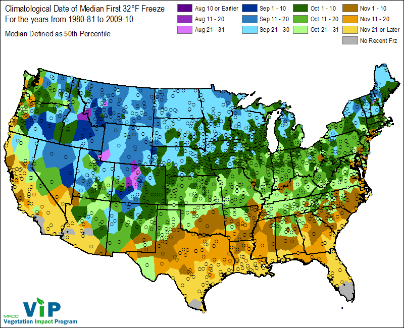
Note that the first freeze in the Upper Midwest averages the last week in September. With a warm Summer, this will not do alot of damage.
The first freeze dates in the Eastern Cornbelt are 10+ days later. Early October in the colder spots, mid October in much of the rest of those locations. This will not do alot of damage with a warm Summer.
If we have freeze dates more than 2 weeks early, then it will do some damage.
Old timers are aware of the Great Labor Day freezes in the Midwest in the early 1970's(either 73 or 74) I'll look back in the records to try to find them.
https://www.weather.gov/iwx/fallfrostinfo
I remember the Father’s day freeze.
I think it got down to 40 or something. Knee high corn froze to the ground, six inch tall beans didn’t.
Folks who cultivated the day before didn’t have their crops freeze. One neighbor cultivated his corn in strips. Every other six rows froze.
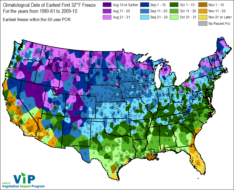
Here are the earliest freeze dates every.
A very rare freeze has happened before along the Canadian border as early as late August. This would be mainly Hard Red Spring wheat country. The HRS crop was actually planted on time this year.
I'm thinking this map may be off for the first freeze dates that occurred in the first few days of September in 1974? in some places in the Upper Midwest, which should have the dark/navy blue shade instead of the medium blue, which is Sept 11-20.
Very rare first freezes have happened in the Eastern cornbelt in the coldest places in mid Sept with most spots having late Sept. The 1995 Sept HARD freezes that went down to the Ohio River were actually around Sept. 23/24 I think. That would hurt the beans for sure and possibly the corn if its cool this Summer.
Again, these are rare events, maybe once every 20 years to get close to that cold so early.
MM, I was wondering about the more direct threat of severe flooding starting Sat thru next week which seems to be centered over the areas that have pounded again again
mcfarm,
There will be alot of unwelcome rains for areas that have not planted yet and some flooding is possible with heavier events but not the extreme rains that occurred in May.
Eric Snodgrass in his forecast today gives a look at historic warm years and the growing degree days needed to Black layer a very late planted crop: (it starts at about the 13:50 point)
https://www.youtube.com/watch?v=qnG9jTCAuGQ
Corn Growing Degree Day (GDD) decision support tool
Thanks much Cutworm!
Great weather presentation and link!
I agree that this corn crop will have a tough time completely maturing before the first freeze................if the first freeze is a couple of weeks early in the Eastern Cornbelt or if we have a very cool Summer.
The good thing is that first freeze dates are 10-14 days later in the Eastern Cornbelt than they are in the Plains and Midwest as early cold blasts from Canada will moderate tracking from that region to the ECB.
If soils remain wet, this will moderate those air masses even more but 3 months from now, who knows what top soil moisture will be like.
In 1995, the last time was had a major damaging freeze because of a late planted crop and early freeze, that Summer was hot and dry and the surface moisture was bone dry when that blast of chilly, very dry air plunged southward.
Instead of moderating, it actually dried out the air mass even more, so when winds dropped to 0 under clear skies, the bottom fell out into the mid 20's in the outlying areas down to the S.IL/IN..........more than 5 degrees lower than the dew points with that air mass.
That cold air pooled into low lying spots overnight. The NWS 5 miles away never got close to freezing on the instrument 5 feet high. Out in the country, in a low spot the water in my garden hose was completely frozen.
I had a huge long position on that weekend based on the freeze and looking at NWS temps staying above freezing all night, I figured beans would open LOWER on Monday.
Then I went to water the vegetables in our garden and the water wouldn't work. I thought the well had gone dry until realizing the water in the garden hose was frozen. Outlying areas reported the same thing.......and the bean fields in the low spots turned sort of a blackish color a few days later, while the high ground stayed green and got an extra 2 weeks to finish.
Beans opened higher that next Monday morning.