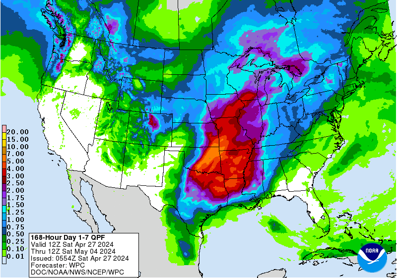
Next 7 days of rain:
http://www.wpc.ncep.noaa.gov/qpf/fill_94qwbg.gif?1526306199054
http://www.wpc.ncep.noaa.gov/qpf/day2.shtml
http://www.wpc.ncep.noaa.gov/qpf/day3.shtml
http://www.wpc.ncep.noaa.gov/qpf/95ep48iwbg_fill.gif?1526306162
http://www.wpc.ncep.noaa.gov/qpf/97ep48iwbg_fill.gif?1526306162
Total accumulation
http://www.wpc.ncep.noaa.gov/qpf/p168i.gif?1526397762
have to tell you metmike if that forecast turns out like last couple of weeks it ain't going to rain. We have had nothing but 40-50-60-70-% chances nearly every day and even that "likely" thing several times and have gotten not a drop. Starting to really show as with those high chances nobody was willing to sock the seed 3 inches deep looking for moisture. Well as it turns out now that seed is laying in dry dirt and acre after acre will not germinate without help
I agree mcfarm,
These rainfall totals keep getting less and less with each forecast. We went from having excessive rains in many places to excessive in a few spots but lots of rain everywhere to maybe completely missing the rains in some places.
7 day total below:

Severe storm risk the next few days....mainly in the Plains......except this
afternoon a moderate risk in the Northeast:
http://www.spc.noaa.gov/products/outlook/
Current Day 1 Outlook | Forecaster: Grams/Coniglio Issued: 15/1613Z Valid: 15/1630Z - 16/1200Z Forecast Risk of Severe Storms: Moderate Risk |
Current Day 2 Outlook | Forecaster: Picca Issued: 15/1720Z Valid: 16/1200Z - 17/1200Z Forecast Risk of Severe Storms: Marginal Risk |
Current Day 3 Outlook | Forecaster: Kerr Issued: 15/0727Z Valid: 17/1200Z - 18/1200Z Forecast Risk of Severe Storms: Slight Risk |
Current Day 4-8 Outlook | Forecaster: Kerr Issued: 15/0856Z Valid: 18/1200Z - 22/1200Z Note: A severe weather area depicted in the Day 4-8 period indicates a 15%, 30% or higher probability for severe thunderstorms (e.g. a 15%, 30% chance that a severe th |
Lastest National Radar Loop:
https://radar.weather.gov/Conus/index_loop.php

Go to: Most Recent Image
This is the area getting clobbered:

Go to: Most Recent Image
...THERE IS A MODERATE RISK OF SEVERE THUNDERSTORMS NORTHEAST PA...FAR NORTHERN NJ...SOUTHERN NY...NORTHWEST CT...SOUTHWEST MA... ...THERE IS A SLIGHT RISK OF SEVERE THUNDERSTORMS SOUTHERN HIGH PLAINS... ...SUMMARY... Widespread damaging winds, a few tornadoes, and scattered large hail is expected across parts of the Northeast States this afternoon into early evening. ...Northeast States... Convective evolution will be tied to an MCV and small convective cluster currently ongoing near the OH/PA border. Robust diabatic heating is underway ahead of this feature with trailing outflow from a lead convective cluster currently crossing the Hudson Valley. 12Z Pittsburgh sounding sampled a favorable environment for destabilization with an EML yielding steep mid-level lapse rates. Warm-sector buoyancy of 1000-2000 J/kg will become common by peak heating. This sounding also sampled the southern periphery of strong 700-500 mb winds. As the OH/PA cluster evolves east and becomes surface-based, convection will organize into a fast-moving QLCS with embedded bowing structures given the strong mid-level westerlies nearly orthogonal to the line. Widespread strong to scattered severe wind gusts appear likely which may yield a derecho, and thus damaging wind coverage probabilities have been increased this outlook. A few cells should form ahead of the developing QLCS, most likely across parts of southern NY/Hudson Valley vicinity into western New England. Supercell wind profiles will support a tornado and large hail risk maximized across this region, with this activity becoming absorbed within the broader QLCS. The severe threat will quickly wane near the Atlantic Coast once the QLCS impinges on the stable marine layer.
NWS week 2 forecast still very warm but above normal rains:
http://www.cpc.ncep.noaa.gov/products/predictions/814day/index.php
| 8 to 14 Day Outlooks | |
| Valid: May 23 to 29, 2018 Updated: 15 May 2018 | |
| Click below for information about how to read 8-14 day outlook maps Temperature Precipitation | |
| Click below for archives of past outlooks (data & graphics), historical analogs to todays forecast, and other formats of the 8-14 day outlooks ArchivesAnalogsLines-Only FormatGIS Data | |
Temperature Probability | |
Precipitation Probability | |
Tornado watch here in Valley Forge Pa. The air is like soup