Who remembers these freezes?
After the record warm March in 2007, mother nature tricked all the plants into coming out of dormancy several weeks early.
Then we got hit with record cold in early April.
It obliterated the apple and peach crops in a dozen states, as well as the Winter Wheat.
It lasted for 4 days, which just kept adding to the damage during that period.
I'll have more on this as the week goes on.
https://www.ncdc.noaa.gov/news/month-climate-history-april-2007-easter-freeze
"Unseasonably warm weather in March 2007 over the eastern half of the United States prompted early growth of many agricultural and horticultural crops, ranging from wheat in the Central Plains to fruit trees and pastures across the Southeast and parts of the Midwest. March monthly temperatures averaged between 2°F and 10°F above average in these areas, contributing to the second warmest March on record for the entire United States at the time.
The March warmth didn’t last long, however. Arctic cold followed in early April with over 1,500 weather stations breaking or matching daily record low temperatures. Low temperatures in the teens occurred throughout the eastern half of the country, and freezing temperatures lasted almost a week in some areas. The duration of the cold combined with strong winds hindered efforts to take freeze protection measures for high-value horticultural crops.
With temperatures well below 25°F in many locations, agricultural officials estimated farmers lost about 90% of their crops. And, many farmers lost nearly all of their crops. The widespread freeze extensively damaged agriculture in Alabama, Arkansas, Georgia, Illinois, Indiana, Iowa, Kansas, Kentucky, Mississippi, Missouri, Nebraska, North Carolina, Ohio, Oklahoma, South Carolina, Tennessee, Virginia, and West Virginia, resulting in over $2 billion in losses"
I remember the event but foggy on how it played out.I recall a suspicion of extensive damage but didnt the market
mostly wait to discount that until it was physically evident later?
Or maybe I just dreamed that.
Thanks mm for jogging my memory.
John
I refer to the wheat crop with this scenario.
The fruit sure was beat up!
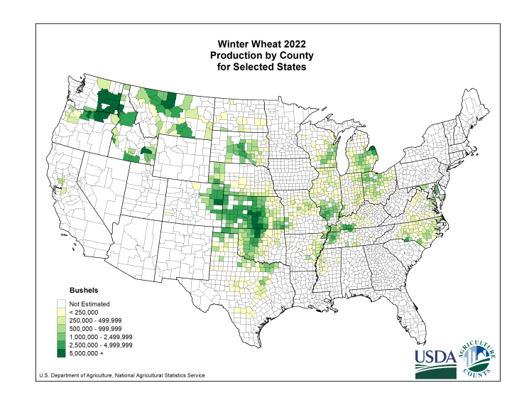
The reason that I brought this up last week is that we have a major freeze event coming up early in the coming wheat for the Hard Red Winter Wheat crop in the Southern Plains.
This is the area of production. Note the concentrated area in #1 Kansas, especially central and western locations, that extends down to OK and N.TX.
This is all HRW wheat. The wheat farther east, starting in MO, is all Soft Red Winter Weather.
https://www.nass.usda.gov/Charts_and_Maps/Crops_County/ww-pr.php
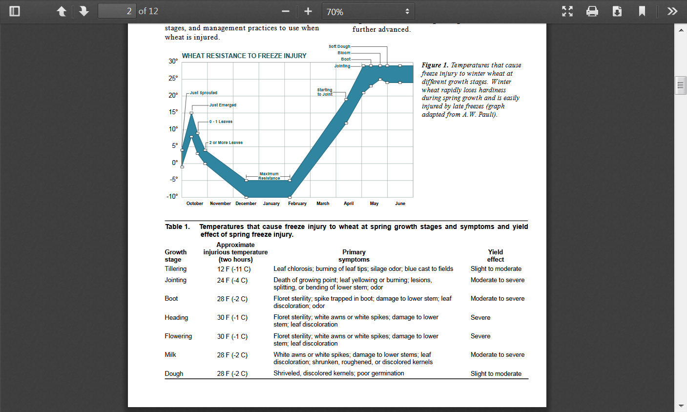
This is a an excellent report/analysis of what Spring freeze damage will occur on a crop that has come out of dormancy, based on the temperatures and what growth stage the wheat is in:
AGRICULTURAL EXPERIMENT STATION AND COOPERATIVE EXTENSION SERVICE KANSAS STATE UNIVERSITY • MANHATTAN SPRING FREEZE INJURY TO KANSAS WHEAT
https://bookstore.ksre.ksu.edu/pubs/c646.pdf
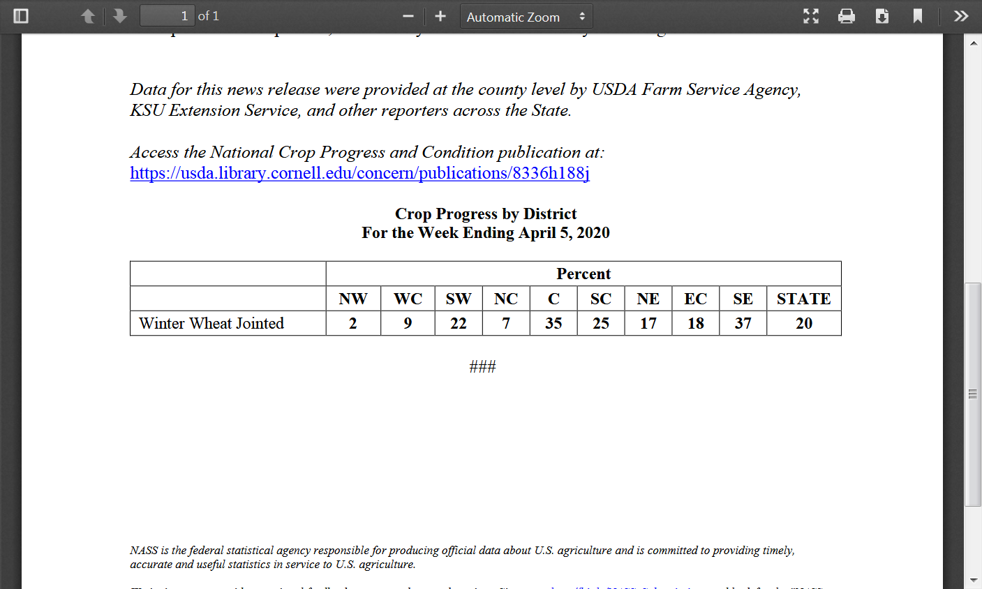
So what stage is the wheat crop in right now in the S.Plains(how vulnerable is it)?
This was the Kansas wheat crop report from conditions that represented a week prior to the freezes coming up.
Looks like the SW/C/SC/SE parts of the state could see some damage with temperatures below 28 but especially if it got down to around 20 deg. F in areas that started jointing 2 weeks ago. Keep in mind that the crop is a week farther along than the numbers below indicate. They state "jointed" but probably its all in the early jointing stage.
The majority of the Oklahoma crop was jointing a week ago.
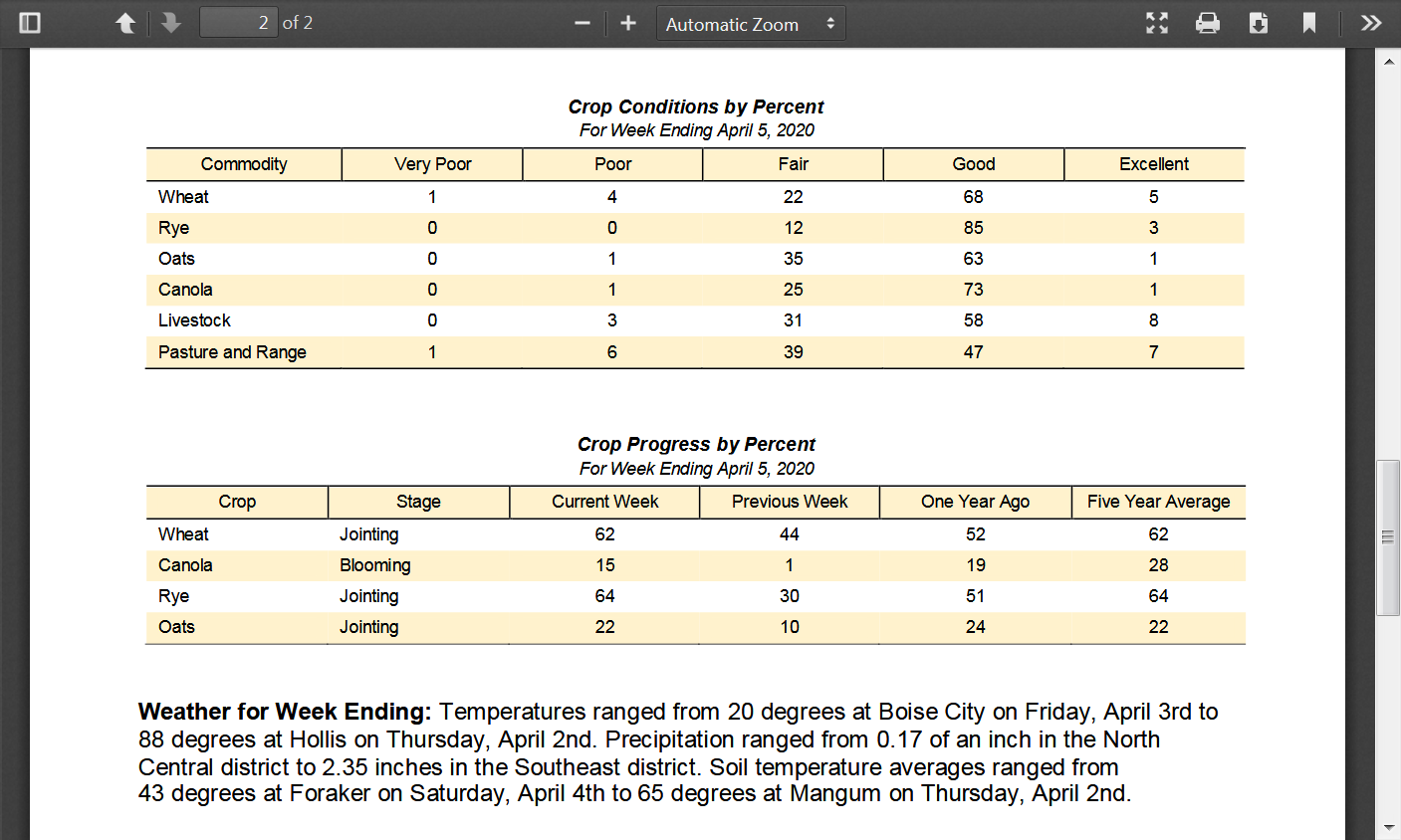
Texas only gives us heading wheat, which is much more advanced and would be hurt with temperatures below 30. 29% of the WW headed is pretty advanced for early April. However, one assumes that the wheat in the panhandle is the least developed(but still more advanced than average) and much of it may not be headed yet but still, temperatures dropping below 30 degrees in the Panhandle may damage some wheat and down to something like 25 degrees may cause serious damage there.
.png)
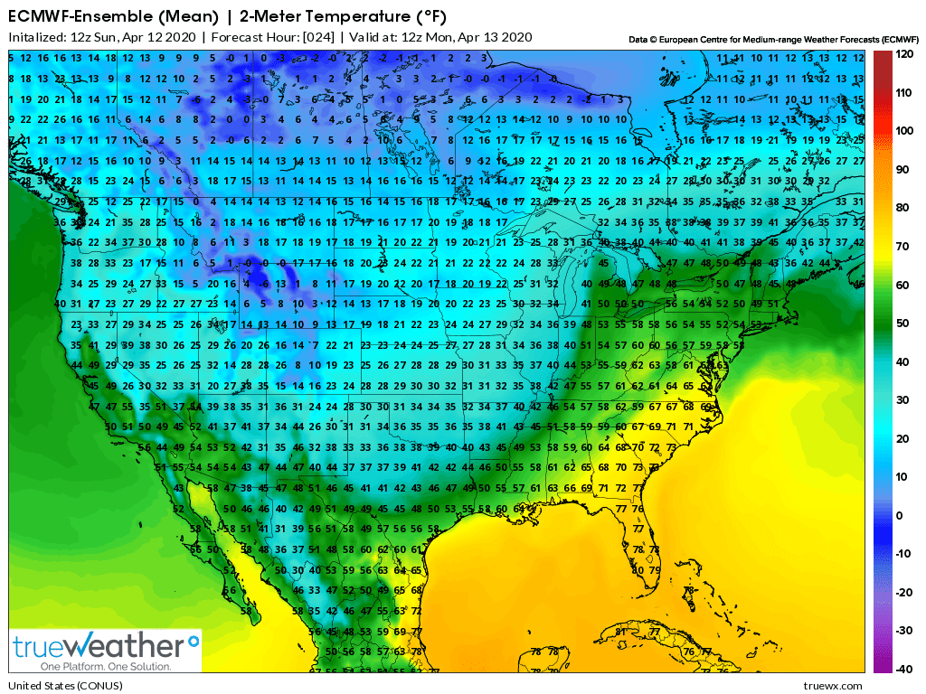
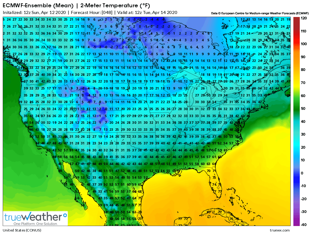
How cold will temperatures get?
These are the computer forecast lows for Monday Morning. They are actually 3-6 degrees warmer than 48 hours ago because of additional clouds that this model thinks will keep it warmer.
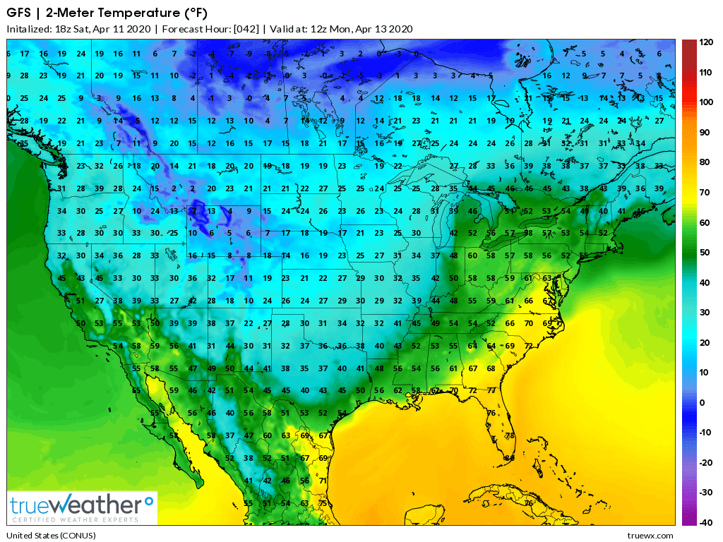
Tuesday morning lows will be almost as cold with less clouds, which will
1. Add to any damage from Monday morning.
2. Increases the chance that 1 of those morning could get much colder than expected and cause significant damage.
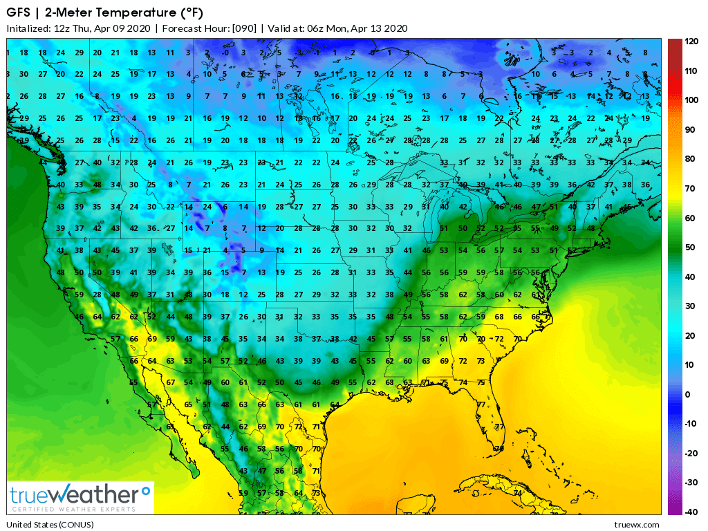
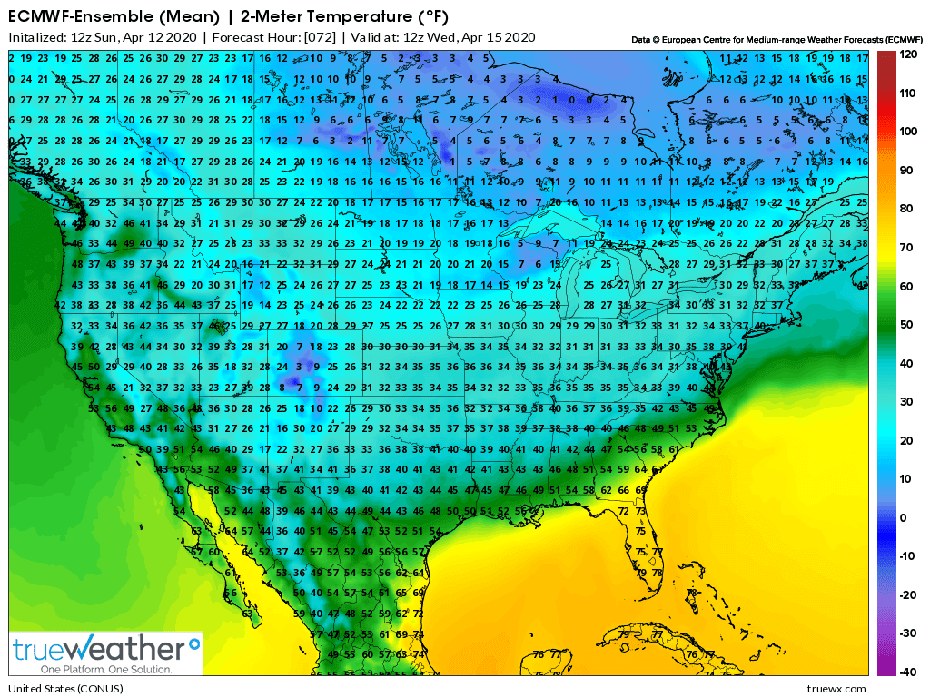
These are lows Wednesday morning. Not quite as cold(especially N.Kansas where the wheat is not as vulnerable) but now we have 3 sub freezing nights/early mornings and some additional damage.
The DDC NWS is MUCH MORE BULLISH with their forecast for the cold, with temperatures down to 20 deg. all the way to the OK border.
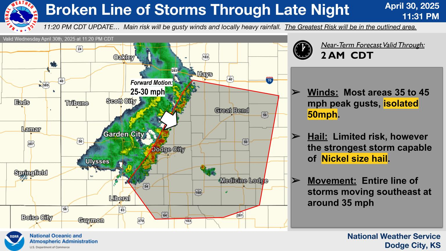
A widespread hard freeze is expected Monday morning, with air temperatures falling into the teens and 20s. Wind chill factors will fall to the 5-15 degree range.
Click a location below for detailed forecast.
From the Texas Panhandle:
They don't have a graphic yet but they take temps into the LOW 20's into the Panhandle. This would do some serious damage to the wheat, especially if there were additional freezes on Tue and Wed.
Winds will be strong on Sunday with sustained winds of 30-40 mph and gusts topping out at 55 mph. Winds will cause issues on east-west roads such as I-40 so take precautions.
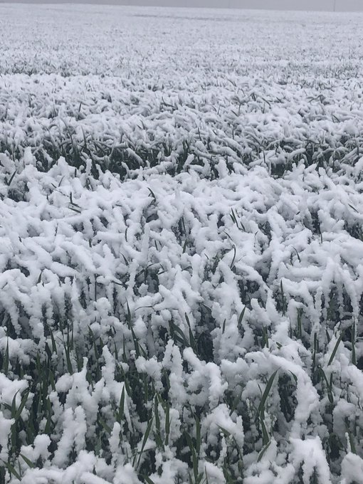
Snow may accumulate Monday night and cause slick roads. Temps are dropping into the 20s so bundle up if outside and protect your plants and pets. Snow looks to start late Monday afternoon and should end around noon on Tuesday.
There are some other things that will likely damage the wheat
One big concern is the wind. If the wheat has any top growth which it does in Texas and possibly else where, the wind could lay the wheat down flat. The wheat will suffer damage to wind. How much we don't know but high winds, will damage wheat when in advanced growth stage
The other damage which nobody has said much about, except the wheat growers is hail. Hail is more localized and a terrible loss for those affected but not so much in the bigger picture
Finally, when crops are damaged, usually the market takes a wait and see attitude. After the 1st spike upward in price, then price levels off or even go down a bit until the market finds out how much damage occurred and then what is the demand for the wheat that is harvested. Or the risk may be priced before the damage even occurs thus not much movement in price. Markets are funny. as Yogi Bear might say. You never know what will happen until it happens Our loss may not hardly register in the larger world demand
And finally, if the wheat is damaged enough to affect grain production, then some acres may be grazed off and not harvested for grain
Thanks Wayne!
Maybe some remember the historic very late Spring heavy snow event in Kansas 3 years ago.
https://www.ksre.k-state.edu/news/stories/2017/05/wheat-snow.html
Assessing the damage: 40 percent of Kansas wheat crop hit by spring snow
Wheat specialist says it will take time to assess damage from wind and below-freezing temperatures

MANHATTAN, Kan. – As usual, Mother Nature will take her time when it comes to revealing the extent of damage to the wheat crop from the spring blizzard that hit western Kansas at the end of April. The storm dumped as much as 21 inches of snow in some areas. Other regions received lesser amounts but were still subjected to below-freezing temperatures and high winds for extended periods, according to the Kansas Weather Data Library.
That combination is a problem for the crop in the stage of development
MANHATTAN, Kan. – As usual, Mother Nature will take her time when it comes to revealing the extent of damage to the wheat crop from the spring blizzard that hit western Kansas at the end of April. The storm dumped as much as 21 inches of snow in some areas. Other regions received lesser amounts but were still subjected to below-freezing temperatures and high winds for extended periods, according to the Kansas Weather Data Library.
That combination is a problem for the crop in the stage of development much of the wheat was in, said Kansas State University assistant agronomy professor Romulo Lollato.
The models are 2-4 degrees warmer than they were at the end of last week for these freeze events. The NWS has not changed and is MUCH colder than even the coldest guidance late last week.
The temperatures below for the next 3 nights would do some damage, especially since its 3 nights in a row vs just 1 night but not nearly as much as temps that were forecast previously by the models.
Looks like clouds and snow will keep the temperature from dropping much more from SW Kansas, southward tonight. The NWS has it going down to 20, all the way down to the OK border in the west. Thinking it may not drop much less than 25 there.
This is the midnight temp below
 https://radar.weather.gov/Conus/uppermissvly_loop.php

Go to: Most Recent Image
Re: Re: Re: Re: Re: Re: Re: Re: Wheat---fade or buy higher open?
0 likes
By metmike - April 14, 2020, 11:29 a.m.
KE wheat got back up to 496 just after midnight on the subfreezing temps but couldn't push over that, then weakened during the early morning hours as the cold event played out more(about as expected).
The regular open saw a huge spike down, with most of the event behind us "buy the rumor sell the fact action"
The coldest temps for KS are over but tonight should be the coldest for TX and will do more damage there as well as another lighter freeze for KS which is not what the already damaged wheat needs.
How much damage was there?
That's a question that only gets answered by monitoring the wheat for a couple of weeks afterward. Winter Wheat is a very hardy crop, so much of it will recover. However, we will have had 3 nights of temps in the 20's in some locations, not just 1 and the locations have moved around.
In many freezes, a big determining factor is the length of time that temps were below the damage threshold or below freezing. If it's less than 4 hours, the wheat often comes out pretty good.
In this instance, the duration of sub freezing temps was unusually long, so one would expect more damage from that element......time below the damage threshold.
We may be hearing reports later this week from that area. It's likely that the crop report next Monday will show a drop in the WW rating for KS/OK/TX and then of course the following week. It might not be that great when seen from the national crop perspective.........maybe just a few % increase in the p/vp?
However, permanent damage may not show up that quickly. Damaged wheat can produce new tillers and the main stem can be completely lost with new tillers compensating for some to most of the damage. How this plays out will not be known for a long time
In the devastating 2007 freeze, I think the main stem was lost from sustained cold over 3-4 days but additional tillers developed or at least survived the freeze and it was speculated, because this was WHEAT, the invincible crop that can't be killed, that those tillers would make up for it. Nope. Too much damage and not enough energy or plant tissue left to bring the plant back to a state which compensated enough, for in many cases worth harvesting.
Tillers that developed after the freeze didn't produce squat.
Here a site that provides current temperatures.......clearly, tonight is not going to be as cold as the last 2 nights, even in TX, unless the bottom falls out with calm winds and clear skies.....looks unlikely.
Joe Baumgardner@BaumgardnerJoe
·
This should be interesting. Don’t remember ever having snow on headed wheat.

On the Ag forum I am reading of concern that dry soil may not let the tillers produce much if any grain
Plus concern about the wheat that is heading out or close
Most think two weeks will be needed to assess damage
P.S. We accumulated approx. 2" of snow this afternoon in about 3 hrs
This morning the soil was dry enough to demonstrate a new field cultivator. This afternoon snow
Even though the air is cold, the soil is warm enough to melt the snow so that in the next hr the snow is almost gone
I think SRW in the area should escape cold temps. Snow won't do any damage. Did not stay for any length of time unless we get more over night, but temps should warm up tomorrow.
Thanks Wayne,
Soil moisture in W.KS/OK/TX is often very low most of the year in most years(which is why they grow wheat/cotton and not much corn out there) but its around average.........but is somewhat dry when you get to the Colorado border into Colorado.
Precip the next 2 weeks look pretty good though, which will help.
![]()

By metmike - April 14, 2020, 8 p.m.
Drought Monitor maps:
Latest: The first map below is the latest. The 2nd one is from last week.
April 8: No drought anywhere in the Midwest. 0% drought there.
The maps below are updated on Thursdays.
https://droughtmonitor.unl.edu/