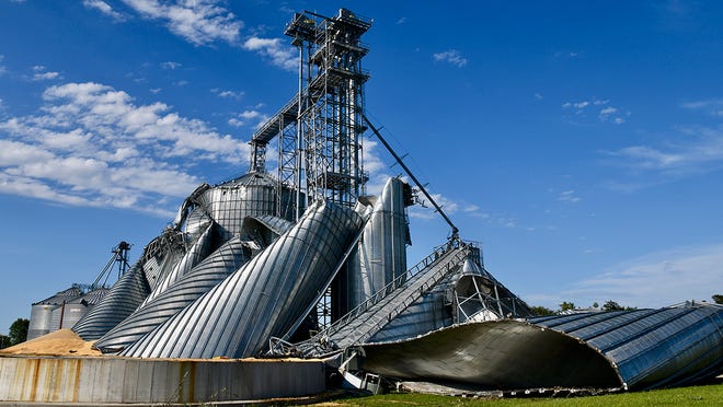
Power out all over Iowa, Illinois. Major bin/elevator damage
Thanks for bringing this up tjc and mcfarm!
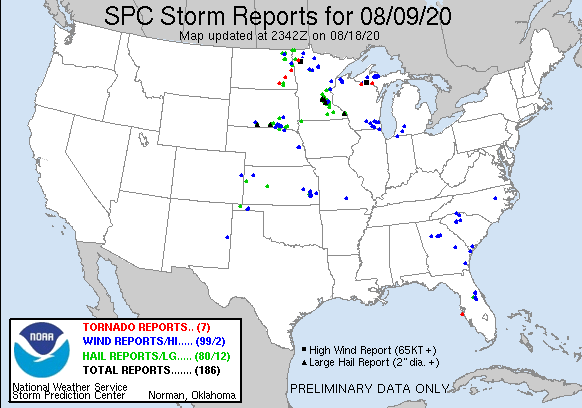
There were 847 reports of winds of 58 mph or greater yesterday, most of them associated with this event.
For perspective, I provided the exact same map from the previous day below....89 reports from the same system.
9-13-21: The updated map from the Severe Storms forecast center is below. The previous day was also updated by the SSFC previously.


A derecho – a dangerous, ferocious wall of wind that's like an inland hurricane – lashed 700 miles across the Midwest on Monday, flipping cars, downing trees, causing widespread property damage and knocking out power to hundreds of thousands.
The derecho lasted several hours, traveling through Nebraska, Iowa, Illinois, Indiana, Wisconsin and Michigan. In Fort Wayne, Indiana, a woman died at a hospital after firefighters pulled her from debris inside her mobile home after high winds rolled it onto its side Monday night.
So far, dozens of injuries but no other fatalities have been reported.
As of Tuesday morning, over 1 million customers were without power, according to Poweroutage.us. Most of the outages were in Illinois and Iowa.
Derechoes are often referred to as inland hurricanes due to their hurricane-like conditions.
“People should take these storms seriously,” National Weather Service meteorologist Brian Barjenbruch said. “These winds are incredibly strong.”
Northern Illinois University meteorology professor Victor Gensini called the derecho one of the worst weather events in the U.S. in 2020. "This is our version of a hurricane," he added.
In order to be classified as a derecho, the storm must include wind gusts of at least 58 mph and its wind damage swath must extend from 250 to 400 miles. The term "straight-line wind damage" sometimes is used to describe derecho damage.
“They are basically self-sustaining amoebas of thunderstorms,” Gensini said. “Once they get going like they did across Iowa, it’s really hard to stop these suckers.”
In all, the National Weather Service's Storm Prediction Center said there were over 500 severe-weather reports across the Midwest on Monday. This included a gust of wind in Midway, Iowa, that measured 112 mph.
The storm hit Chicago in the early afternoon, prompting the National Weather Service to warn that travel plans be altered and loose objects be secured.
The storm brought winds of 92 mph near Dixon, about 100 miles west of Chicago, the National Weather Service reported, as it ripped through buildings, power lines and trees.
Downed branches and trees, flooding, car crashes, and road blockages were reported throughout Chicago and most of Illinois. Trees around 70 to 80 years old were torn to shreds by the high winds in River Grove, ABC Chicago reported
A derecho (/dəˈreɪtʃoʊ/, from Spanish: derecho [deˈɾetʃo], "straight") is a widespread, long-lived, straight-line wind storm that is associated with a fast-moving group of severe thunderstorms known as a mesoscale convective system.[1]

Development of derechos

Composite radar image of the June 2012 North American derecho (a progressive derecho) as it moved from Indiana to Virginia

A typical multi-bow serial derecho

A typical progressive derecho
Derecho comes from the Spanish word in adjective form for "straight" (or "direct"), in contrast with a tornado which is a "twisted" wind.[3] The word was first used in the American Meteorological Journal in 1888 by Gustavus Detlef Hinrichs in a paper describing the phenomenon and based on a significant derecho event that crossed Iowa on 31 July 1877.[4]
Organized areas of thunderstorm activity reinforce pre-existing frontal zones, and can outrun cold fronts. The resultant mesoscale convective system (MCS) often forms at the point of the strongest divergence of the upper-level flow in the area of greatest low-level inflow and convergence.[clarification needed][5] The convection tends to move east or toward the equator, roughly parallel to low-level thickness lines and usually somewhat to the right of the mean tropospheric flow. When the convection is strongly linear or slightly curved, the MCS is called a squall line, with the strongest winds typically occurring just behind the leading edge of the significant wind shift and pressure rise.[6]
Classic derechos occur with squall lines that contain bow- or spearhead-shaped features as seen by weather radar that are known as bow echoes or spearhead echoes. Squall lines typically "bow out" due to the formation of a mesoscale high pressure system which forms within the stratiform rain area behind the initial convective line. This high pressure area is formed due to strong descending air currents behind the squall line, and could come in the form of a downburst.[7] The size of the bow may vary, and the storms associated with the bow may die and redevelop.
During the cool season within the Northern Hemisphere, derechos generally develop within a pattern of mid-tropospheric southwesterly winds, in an environment of low to moderate atmospheric instability (caused by relative warmth and moisture near ground level, with cooler air aloft, as measured by convective available potential energy), and high values of vertical wind shear (20 m/s [72 km/h; 39 kn; 45 mph]) within the lowest 5 km [16,000 feet] of the atmosphere).
Warm season derechos in the Northern Hemisphere most often form in west to northwesterly flow at mid-levels of the troposphere, with moderate to high levels of thermodynamic instability. As previously mentioned, derechos favor environments of low-level warm advection and significant low-level moisture.[8]
A common definition is a thunderstorm complex that produces a damaging wind swath of at at least 400 km (250 miles),[9] featuring a concentrated area of convectively-induced wind gusts exceeding 30 m/s (90 km/h; 50 kn; 60 mph).[1] According to the National Weather Service (NWS) criterion, a derecho is classified as a band of storms that have winds of at least 30 m/s (90 km/h; 50 kn; 60 mph) along the entire span of the storm front, maintained over a time span of at least six hours. Some studies add a requirement that no more than two or three hours separate any two successive wind reports.[10] A more recent, more physically-based definition of "derecho" proposes that the term be reserved for use with convective systems that not only contain unique radar-observed features such as bow echoes and mesovortices, but also for events that produce damage swaths at least 100 km (60 miles) wide and 650 km (400 miles) long.
I witnessed one of the most intense DERECHO's in history, in July 1980 before the term was more widely used while in my last year at the University of Michigan, studying meteorology.
I was lifting weights in the basement of the Ann Arbor YMCA very early in the morning, before going to my Summer job as a dietary supervisor at the University of Michigan Hospital.
We had no internet or electronic devises to track such things, so it was the flickering lights that sent me upstairs and outside to see the first green skies and cumulo nimbus mammatus clouds in my life.
Below is an example of what those kind of clouds look like. On that day, it was very early in the day and the sky was pea green.

We got lucky in my location and had almost no damage.
However, a couple of days later, I made a trip home to Detroit, traveling eastbound on I-94 for around 35 miles and was dumbfounded. The majority of trees, many thousands over a section of more than a dozen miles had been completely flattened.
Turns out that there were winds gusts as high as 150 mph reported.............double the intensity of a minimal hurricane.
Here's is the detailed analysis of that historic event done years later.
Weather Forecast Office
Weather.gov > Detroit/Pontiac, MI > The July 16th, 1980, Derecho
https://www.weather.gov/dtx/1980derecho
While the sky was relatively bright at sunrise over Southeast Lower Michigan, a band of foreboding clouds advanced in quickly from the west, covering the celestial dome. As the forceful storms and associated hurricane force winds approached the area, several observers remarked about the horrid dark green color the sky took on as the squall moved overhead. In fact, numerous people over the years have commented about the "dark pea green sky" that accompanied the July 16th 1980 storm. The green color in the sky may have been reflective of the low sun angle at the time (the derecho moved through region between 730 and 930 AM EDT) and abundance of moisture in the low clouds. It got so dark that many street lights were triggered and popped on over portions of the region. Severe thunderstorm warnings were issued over the region though some remarked: "it happened so quickly and early in the day, it caught us off guard".
The hardest hit regions across Southeast Lower Michigan were Washtenaw and Wayne counties, extending mainly from the Ann Arbor area east into southern sections of Detroit (or south of the Ford Road /M-153/ corridor). While the wind officially gusted to 71 mph at Detroit Metro Airport, much higher winds were reported in other areas (see storm report below) in the strongest core of the derecho.
As one person who witnessed the swath of damage across southern portions of Washtenaw and Wayne counties, the following excerpts from storm data relay the incredible outcome of the storm. In the storm data below, the derecho is referred to as a downburst. In addition, the derecho was accompanied by a small tornado as it exited extreme Southeast Lower Michigan. Tornadoes can occur in isolated thunderstorm supercells ahead of the derecho producing squall line or they may be associated with the squall line itself.
| STORM DATA | ||
| Counties in SE Mich | Date 7/16/80 | Time 830-920AM EDT |
| Washtenaw Wayne Monroe | "Intense downburst developed just west of Ann Arbor. Path of the most intense damage across southern Ann Arbor then eastward through the Downriver suburbs of Detroit. Winds estimated up to 100 mph in Washtenaw county, up to 150 mph in Wayne County. Innumerable buildings, vehicles and trees destroyed in eastern Washtenaw, central and southern Wayne, and northeastern Monroe counties. Several boats were swamped on the Detroit River. Power off in some areas up to ten days." | |
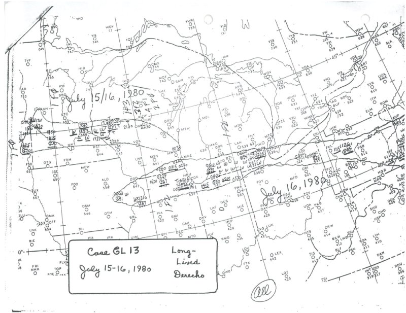
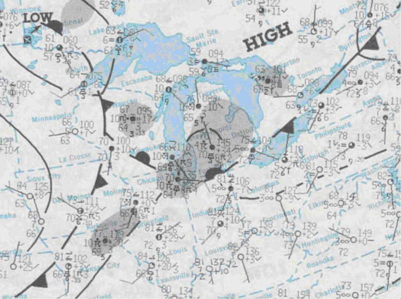 A low pressure area with attending warm and cold fronts (map-2) pushing through the Upper Midwest was responsible in igniting the derecho at the surface late on the 15th. Thunderstorms developing over extreme Eastern Iowa and Northern Illinois during the very early morning hours of the 16th, intensified and formed into a squall line that pushed through Northern Illinois between 3 AM and 5 AM EDT. The storms were spawned out ahead of the frontal system as it approached northern Illinois, mainly ahead of the triple point juncture and nearly perpendicular to the warm front. At the same time, a potent mid level short wave (map-3) and wind max (approx 60-70 knots) surged east across the Upper Midwest toward the Southern Great Lakes.
tjc,
I am not able to ascertain the amount of damage just from severe weather reports at this time.
These events are not that common in the Cornbelt and this year, coming in the 2nd week of August, MIGHT do more damage to the more mature corn crop than a similar event would have done earlier in the Summer(when they are more common but still rare).
A Derecho that happens before pollination, for instance will hit corn plants that don't have some heavy ears of corn making them more top heavy and easier to blow down or snap.
However, the stalks may be weaker early in the season.
https://en.wikipedia.org/wiki/List_of_derecho_events
Here are some articles that discuss wind damage.
There is tremendous uncertainty expressed in the articles, especially with regards to the outcome of flattened corn.
Much of it can straighten up enough so that yields losses are not as great as one would think(according to the articles)
Obviously, if plants experienced "green snap" they are toast, especially considering the the fact that heavy ears on the plants right now, would cause the breakage point to be BELOW the ears. So even if the plant was still alive but just cut shorter, the ears are gone.
What are the reports saying?
Producers, when discussing damage to their crop are sort of like CNN discussing Trump(-:
Things are always described as much worse than they really are. Pictures from the worst part of the field and pictures from the worst fields are the ones that flood the internet.............even if they only represent a small fraction of the crop.
Nobody sends pictures of good looking corn after a damaging weather event.
Crop Watch: Corn plants are more vulnerable early and late in the season.
https://www.farmprogress.com/story-wind-damage-hits-matters-corn-9-144224
Typically, if plants are left leaning after a storm, they will straighten back up. Some plants may snap off. Often that's called "green snap," Nanda says. Obviously, if plants snap off with the growing point aboveground, which is typically the case, those plants are done.
This is a great article but applies mainly to plants earlier this year that were hit by damaging winds.
Institute of Agriculture and Natural Resources
Wind-Damage to Corn July 16, 2020
Just read an update on Monday storm
37 million acres affected in Mid West
14 million of corn and beans in Iowa
Many acres of severely damaged fields will not recover
Policy holders are asked to report crop claims as soon as possible
Additional damage to storage bins, houses, equipment storage, hydro poles, trees etc
We were on southern edge of storm. 50 mph winds. Crops had minimal damage and didn't lose power ! 50 miles north at the Quad Cities, many still without power 5 days later. What a mess !
Glad that you just missed the major damage bowyer!
Sort of like getting reverse harley-ed with wind from storms.........instead of the beneficial rains from a huge rain system.... drying up as they approach your farm during a dry period, this was damaging winds from a huge Derecho, weakening to sub damaging winds as they approached your farm!
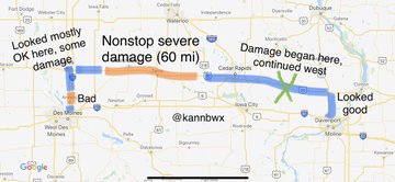
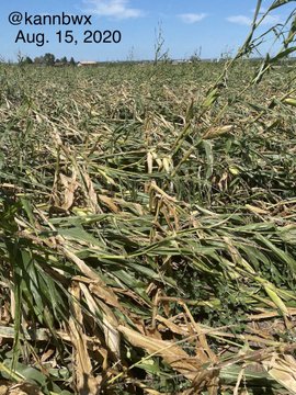
Mini trip report through some of the Iowa damage. Route was Davenport to Des Moines, through Cedar Rapids & Ames on U.S. 30. Damage could be seen most of the way, but almost everything was catastrophic in a 60 mile stretch east of Ames. #Corn flattened, bins & buildings shredded.
Since Biden made reference to the Derecho event last year(they don't call them tornadoes anymore), I just went in an updated the severe weather reports for that date 8-10-20, which is also our wedding anniversary.
https://www.marketforum.com/forum/topic/57424/#57433
It was noteworthy enough to still be of interest here, over a year later.