The current tropics thread was getting loo long to scroll. So, here's a new one and it starts off with a bang/no rest for the weary:
ZCZC MIATWOAT ALL TTAA00 KNHC DDHHMM
Tropical Weather Outlook NWS National Hurricane Center Miami FL 800 PM EDT Thu Oct 29 2020
For the North Atlantic...Caribbean Sea and the Gulf of Mexico:
The National Hurricane Center has issued the last advisory on Post-Tropical Cyclone Zeta, located over the western Atlantic Ocean off of the coast of the Mid-Atlantic states.
1. A large area of disturbed weather in the vicinity of the Lesser Antilles is associated with a tropical wave.  Upper-level winds are expected to become more conducive for development of this disturbance during the next few days, and a tropical depression is likely to form by the time the system reaches the western Caribbean Sea early next week. * Formation chance through 48 hours...low...30 percent. * Formation chance through 5 days...high...70 percent.
Forecaster Beven
This has just been designated as Invest 96L! I, like many, am exhausted!
Thank you very much Larry!
Here's the link to the NHC
Link to the previous tropical weather thread:
https://www.marketforum.com/forum/topic/59336/
TD 29 was declared at 5 PM EDT today, is forecasted to become a hurricane (Eta) tomorrow night, and is forecasted to make landfall in N Nicaragua Tue afternoon. Related to this, below is the very ominous 12Z Euro 7 day rainfall projection, which would be quite historic by any measure should it verify closely. Many of these 7 day amounts are easily several months worth of the normal rainfall, especially in Honduras, NW Nicaragua, east central Guatemala, and SE costa Rica, where 8-24" is on this map:

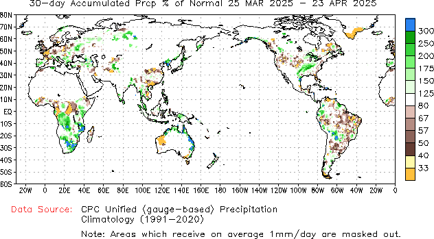
What makes this more ominous is that the rainfall in recent months over these areas has been much heavier than normal. Here is the October rainfall, which is 150%-200%+ of normal in the areas most at risk (you have to enlarge this to see that most of C America is green or blue):

That map updates daily and is from here:
https://www.cpc.ncep.noaa.gov/products/Precip_Monitoring/Figures/global/n.30day.figb.gif
Looking further back, the maps for 90 and 180 days are similarly wet.
I found this NHC snippet addressing the likelihood of torrential rainfall over portions of Central America to be the most alarming and is why I started monitoring this carefully a few days ago in the coffee thread:
"Through Thursday afternoon, the depression is expected to cause 5 to 10 inches of rain, with local 15-inch amounts, across Jamaica, the Cayman Islands, and possibly the southern coast of Hispaniola. Across portions of Central America, 10 to 15 inches of rain, with local amounts to 25 inches are expected. This rainfall should lead to flash flooding and river flooding, and could cause landslides in areas of higher terrain."
What makes this more ominous is that the rainfall in recent months over these areas has been much heavier than normal. Here is the October rainfall, which is 150%-200%+ of normal in the areas most at risk (you have to enlarge this to see that most of C America is green or blue):
Looking further back, the maps for 90 and 180 days are similarly wet.
From NHC's initial advisory:
Great stuff Larry!
ETA to become a minimal hurricane before hitting Central America this week:
In November, we usually see the hurricane activity shift south as temperatures cool in the Northern Hemisphere.
Some changes to the ETA forecast this morning!
Becoming a major hurricane before hitting Nicaragua, then weakening quickly:
https://www.nhc.noaa.gov/graphics_at4.shtml?start#contents
![[Key Messages]](https://www.nhc.noaa.gov/storm_graphics/AT29/refresh/AL292020_key_messages+png/174959_key_messages_sm.png)
Eta up to 150 mph going to 160 before hitting the East Coast of Nicaragua tomorrow.
https://www.nhc.noaa.gov/graphics_at4.shtml?start#contents
Far eastern and Northeastern Nicaragua is going to be obliterated.
Eta weakened a bit overnight down to 145 mph and is losing strength.
Will be making landfall on the Nicaragua coast today, then weakening quickly because of the mountains.
Still dumping torrential rains though with slow movement.
https://www.nhc.noaa.gov/graphics_at4.shtml?start#contents
https://weather.com/storms/hurricane/news/2020-11-02-hurricane-eta-mitch-1998-thousands-killed
Eta down to a TS and rapidly weakening.
Looks like Eta will be tracking too fast for us to see Mitch like rains(Mitch tracked MUCH slower).
.png)
https://www.nhc.noaa.gov/graphics_at4.shtml?start#contents
![[Key Messages]](https://www.nhc.noaa.gov/storm_graphics/AT29/refresh/AL292020_key_messages+png/174817_key_messages_sm.png)
Remember Eta?
Sorry for not updating the last few days but it's still out there and now, has worked north to the eastern Gulf of Mexico!
https://www.nhc.noaa.gov/graphics_at4.shtml?start#contents
![[Key Messages]](https://www.nhc.noaa.gov/storm_graphics/AT29/refresh/AL292020_key_messages+png/145539_key_messages_sm.png)
+++++++++++++++++++++++++++++++++++++++++++
Nov. 9th, afternoon update:
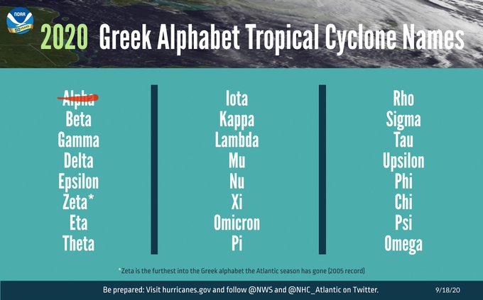
The next potentially named system is forming in the Atlantic and will be called Theta, if it gets strong enough(no threat). The one after that, would be called Iota. I love that Greek name........also used in the English language to mean a very tiny amount.
November 10 update:
Potential Iota on the map now in the Caribbean.
|
Lets track Eta for the rest of the week for you below.
I will keep this graphic at the bottom of our updates and make updates this week ABOVE this.


Go to: Most Recent Image
We continue to track TS Eta above.
https://www.nhc.noaa.gov/graphics_at4.shtml?start#contents
Maybe a TS most of the time.........potential for minimal hurricane the rest of the week and very slow north/notheast movement in the Eastern GOM, aimed at northern Florida.
Potential storm Iota showing up in the Caribbean!
We continue to track TS Eta above.
https://www.nhc.noaa.gov/graphics_at4.shtml?start#contents
Theta was named and that's #29 for this year..............a new record.
Potential storm Iota showing up in the Caribbean will be #30.
More on the hurricane season here:
Relevant Radio show
Almost Iota to become a cat. 2 hurricane in the Caribbean then hit C.America.
https://www.nhc.noaa.gov/refresh/graphics_at1+shtml/155412.shtml?3-daynl

the system has the potential to produce 20 to 30 inches of rain with a focus across northern Nicaragua and Honduras.
Iota has roared up to a 160 mph major hurricane and is going to clobber some of the same areas that were hit by Eta just over 2 weeks ago.
Nicaragua and Honduras WILL BE hit especially hard.
https://www.nhc.noaa.gov/refresh/graphics_at1+shtml/155412.shtml?3-daynl
Iota is making landfall on the Northeast Coast of Nicaragua right now.
Iota now rapidly weakening to a TStorm today, then depression but still dumping massive rains.
