Most weather maps on MarketForum are updated constantly, from radar images every few minutes to daily precip/models.This causes my descriptions of some of the maps(which only comes out with the initial post) to be outdated later on or the next day. Every day, we just start over again with new descriptions and new maps. Please enjoy the comprehensive coverage of your weather here!
Note: Main feature: Stationary front below.
https://weather.com/maps/currentusweather

Here is the latest radar image. You can see the rains along that front.

Rains the past 24 hours......heaviest in Plains, Western Cornbelt, south of Ohio River.![]()
Most importantly........forecast rains.
Rains the next 7 days ......... Still like a broken record....dumping on much of the country............... rain makes grain still but this pattern is going to change...........things will be shifting.
Day 1:
http://www.wpc.ncep.noaa.gov/qpf/fill_94qwbg.gif?1526306199054
Day 2:
http://www.wpc.ncep.noaa.gov/qpf/fill_98qwbg.gif?1528293750112
Day 3:
http://www.wpc.ncep.noaa.gov/qpf/fill_99qwbg.gif?1528293842764
Days 4-5:
http://www.wpc.ncep.noaa.gov/qpf/95ep48iwbg_fill.gif?1526306162
Days 6-7:
http://www.wpc.ncep.noaa.gov/qpf/97ep48iwbg_fill.gif?1526306162
Total accumulation
http://www.wpc.ncep.noaa.gov/qpf/p168i.gif?1526397762

Some areas have a threat for excessive rains.......moving back north then east as the heat ridge builds. Hit the map for full screen.
http://www.wpc.ncep.noaa.gov/qpf/excess_rain.shtml
Current Day 1 Forecast Valid 15Z 06/11/18 - 12Z 06/12/18 |
Day 1 Threat Area in Text Format
| Day 2 and Day 3 Forecasts |
Current Day 2 Forecast Valid 12Z 06/12/18 - 12Z 06/13/18 |
Day 2 Threat Area in Text Format
Current Day 3 Forecast |
Severe Storm Risk. Push your cursor on the map for full screen.
https://www.spc.noaa.gov/products/outlook/
Current Day 1 Outlook | Forecaster: Hart/Kerr Issued: 18/1240Z Valid: 18/1300Z - 19/1200Z Forecast Risk of Severe Storms: Slight Risk |
Current Day 2 Outlook | Forecaster: Bunting Issued: 18/0600Z Valid: 19/1200Z - 20/1200Z Forecast Risk of Severe Storms: Marginal Risk |
Current Day 3 Outlook | Forecaster: Bunting Issued: 18/0731Z Valid: 20/1200Z - 21/1200Z Forecast Risk of Severe Storms: Marginal Risk |
Current Day 4-8 Outlook |
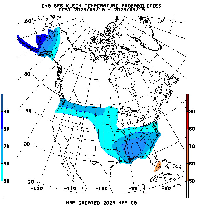
High Temperatures today and Tuesday.......cool Upper Midwest and Northeast......hot south.


Highs days 3-7 shows Blistering heat from C/S Plains to S.Midwest, spreading northeast, eventually Northeast, with near record highs there.


You won't see this too often. A 100% chance of above normal temperatures on NWS 6-10 day guidance for the S. Great Lakes region:
From the GFS ensemble mean products. Temperature anomalies for ts coming weekend:

Temperature anamolies at the end of week 2.....most intense heat shifted west:

Canadian model ensemble mean control at the top, with individual members below. Still much disagreement on where the massive, upper level high pressure heat ridge will be.
384h GZ 500 forecast valid on Jul 11, 2018 00 UTC


Forecasts for the control (GEM 0) and the 20 ensemble members (global model not available)
The Nino 3.4 region of the equatorial Paciifc warmed from +0.2 to +0.4 in today's weekly update. The subsurface also warmed slightly. This tells me that El Nino is looking more and more likely by autumn and continuing into winter though it is still not a lock. More than likely it won't be a strong El Nino if it occurs. So, assuming this to be true, this would not be a strong enough El Nino to likely lead to near nationwide warmth in the E US. A weak to moderate El Nino has in the past in some cases, especially when there was the right mix of ingredients like -NAO and +PDO, lead to some very cold South-central US/SE US/Mid Atlantic winters that sometimes have extended into much of the Midwest and the NE. Examples: 1969-70, 1976-7 & 1977-8.
The June Eurosip ensemble of models recently updated and is a little warmer than the May update with low end weak El Niño (near +0.5 in Niño 3.4) for August/Sept/Oct averaged out with it warming to near +0.6 in Oct. This near +0.5 compares to near +0.35 for ASO in the May update. The exact number isn't important but the point is that trends are warming, which increases the chance for El Nino later this year.
Consistent with this warmer Eurosip in Nino 3.4, the June Eurosip update has even higher averaged pressures in the Atlantic tropics (MDR) for Aug/Sep/Oct from near 30W westward through the Caribbean and the GOM vs the already pretty high pressures shown in the May update. This update now has slightly higher pressure than the June ASO forecast for 2014. The June forecast for ASO 2015 is still somewhat higher with the pressures and is the only June forecast showing higher ASO pressures vs 2018. The message is clearly to expect a pretty quiet season in the MDR through the GOM overall with perhaps near normal north of 30-35N east of the CONUS to possibly up to near the NE US/SE Canada assuming this forecast has a decent clue.
Have you noticed that we must farm in an arid climate
We are 70 miles from Detroit on the Canadian side of Lake Erie
At least not as many days of heat coming as some areas but our heat is usually not until mid July
Rather early to have high temps in the southern Great Lakes
What will July and Aug temps bring for pollination and kernel fill???
We look to miss most of the rain except for one small chance
Re: Your maps
No have had no measurable rain since Mid May until past week end
Crops were suffering bigly
A small cell opened up and gave us 2" on most of our farms
this past weekend
Hope that small chance of rain develops, this coming week
We really need more rain, but we need orange for rain
Our rain fall has changed over the yrs.
We used to be wet all summer
I remember being stuck in the mud on tiled ground harvesting SRW in July
"A small cell opened up and gave us 2" on most of our farms
this past weekend"
Glad to hear that Wayne!
Maybe you can get another one like that on Wednesday:

Thanks Larry!
When the trend is in this direction during the growing season, it increases odds of wet weather in the Cornbelt.
I realize that your post discusses the forecast for later this year but the SST anamolies in that region climbing the last couple of months have increased chances of wet weather in the Cornbelt for the J-J-A period.
We've had a significant increase since early this year as seen below:

This is also why La Nina's elevate drought chances in the Cornbelt and El Nino's decrease drought chances. We are neutral right now but the direction of change is also a factor.............increasing =+rain chances decreasing =-rain chances.
Agree of course on the potential effect of this come Winter 2018/19.
The other story...too much rain on the Plain makes raising grain a pain. And the rainfall totals have increased thru out SE. SD. NW Ia. and the lower third of Mn.
http://www.keloland.com/news/article/weather/rain-totals-across-the-state
Thanks Cliff!
Yes, there has been too much rain in some areas. Maybe enough loss of nitrogen in the soils there too to effect yields.
Crops ratings still say the overall crop is up there in potential record yeild territory.
https://talk.newagtalk.com/forums/thread-view.asp?tid=790526&mid=6834302#M6834302 despite the record rains in northern Iowa and S Minn and many crops hurting this is an estimate of crop yield to date....pretty fancy numbers
https://talk.newagtalk.com/forums/thread-view.asp?tid=790526&mid=6834302#M6834302 despite the record rains in northern Iowa and S Minn and many crops hurting this is an estimate of crop yield to date....pretty fancy numbers
Farm Progress is living in a world of BS and fantasy if they think Mn. will achieve those yield numbers. We have entirely too much water standing in fields in places and many acres of both corn and soybeans have yet to be sprayed. On June 19 we saw some "dicamba desperation" spraying of soybeans in misty,drizzly conditions that will cause that effort to fail. Prior to that we saw it being sprayed "off label" in too hot and/or windy conditions But dicamba use was very limited as too many were afraid to use use it even though they paid for the seed to do so and/or spraying conditions prohibited it. And as of June 20 dicamba's not legal to use on soybeans so those who haven't sprayed will be using chemicals that will burn and stunt the soybean plants. Fortunately those of us who planted Liberty soybeans have some time yet to spray Liberty herbicide to control weeds.
