
Most maps below are constantly updated
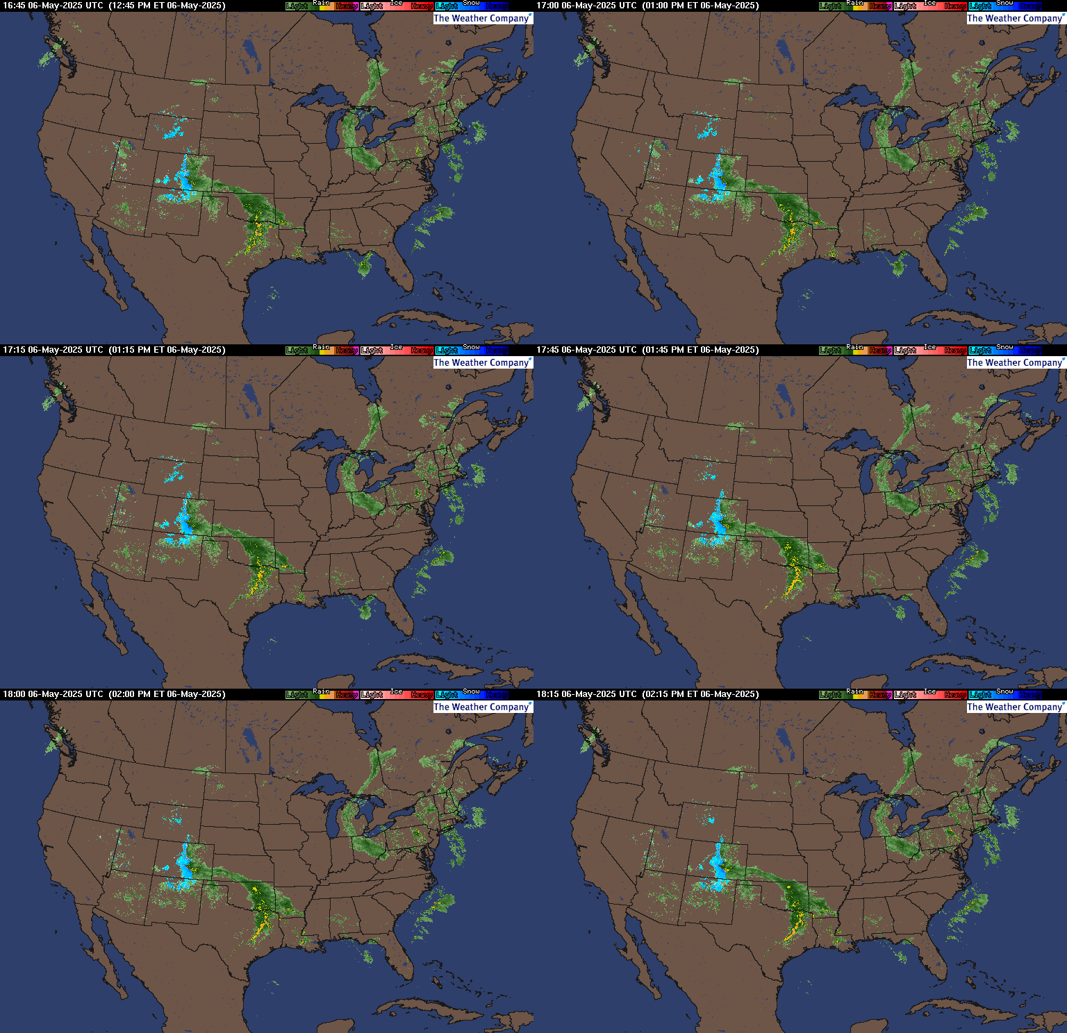
Latest National radar images
https://www.wunderground.com/maps/radar/current
This link below provides some great data. Hit the center of the box below for the area that you want, then go to observation on the far left, then surface observations to get constantly updated surface observations.
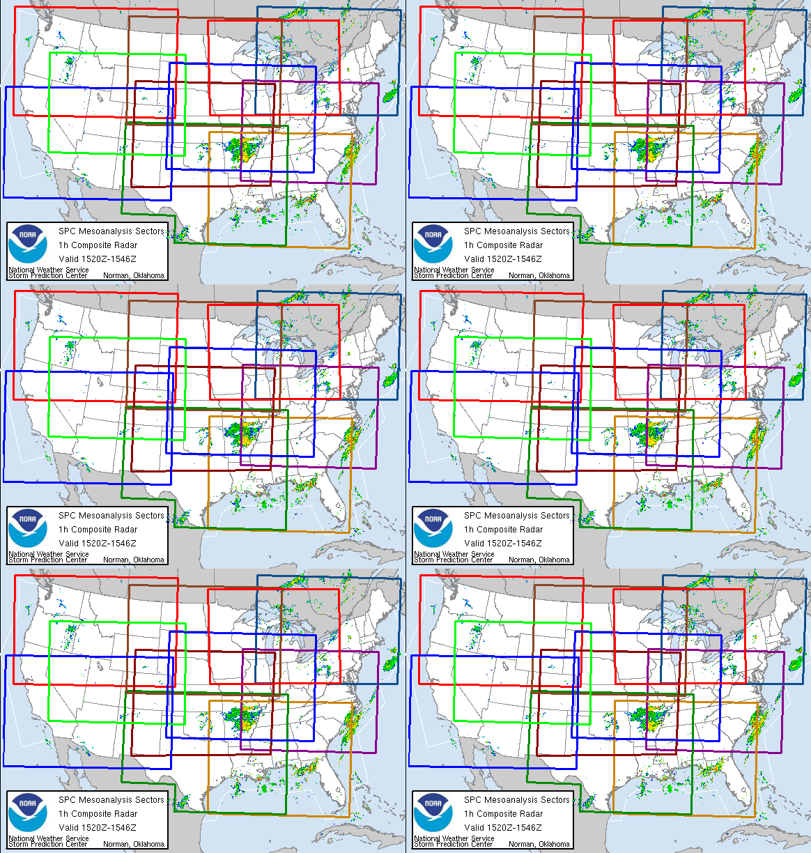 |
Current Conditions below updated every few minutes.
https://www.spc.noaa.gov/exper/mesoanalysis/new/viewsector.php?sector=13#


https://www.spc.noaa.gov/exper/mesoanalysis/new/viewsector.php?sector=20


Surface moisture in the air:

The latest precip forecasts are below.
Day 1 below:
http://www.wpc.ncep.noaa.gov/qpf/fill_94qwbg.gif?1526306199054

Day 2 below:
http://www.wpc.ncep.noaa.gov/qpf/fill_98qwbg.gif?1528293750112

Day 3 below:
http://www.wpc.ncep.noaa.gov/qpf/fill_99qwbg.gif?1528293842764

Days 4-5 below:
http://www.wpc.ncep.noaa.gov/qpf/95ep48iwbg_fill.gif?1526306162

Days 6-7 below:
http://www.wpc.ncep.noaa.gov/qpf/97ep48iwbg_fill.gif?1526306162

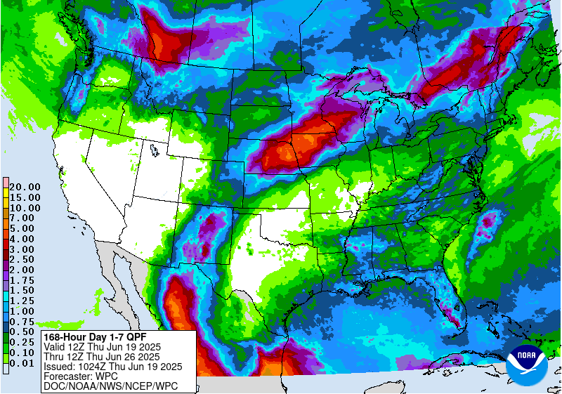
7 Day Total precipitation below:
http://www.wpc.ncep.noaa.govcdx /qpf/p168i.gif?1530796126
https://www.wpc.ncep.noaa.gov/qpf/excess_rain.shtml
Day 1 Threat Area in Text Format
Current Day 2 Forecast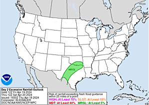 |
Severe Storm Risk......updated constantly.
https://www.spc.noaa.gov/products/outlook/
Current Day 1 Outlook | |
Current Day 2 Outlook | |
Current Day 3 Outlook | |
Current Day 4-8 Outlook |
https://weatherstreet.com/weather-forecast/Snow-Depth-US.htm
National Snow Analyses
https://www.nohrsc.noaa.gov/nsa/
Current Snow Depth
https://www.wunderground.com/maps/snow/snow-cover
Winter weather link from the NWS experts:
https://www.wpc.ncep.noaa.gov/wwd/winter_wx.shtml

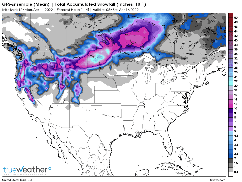
Snowfall this week
Freezing rain/ice the next 3 days:
https://www.wpc.ncep.noaa.gov/wwd/winter_wx.shtml
Extended weather.
https://www.cpc.ncep.noaa.gov/products/predictions/610day/ | |||||||||
| 6 to 10 day outlooks | |||||||||
| Click below for information about how to read 6-10 day outlook maps Temperature Precipitation | |||||||||
| Click below for archives of past outlooks (data & graphics), historical analogs to todays forecast, and other formats of the 6-10 day outlooks ArchivesAnalogsLines-Only FormatGIS Data | |||||||||
Temperature Probability | |||||||||
Precipitation Probability | |||||||||
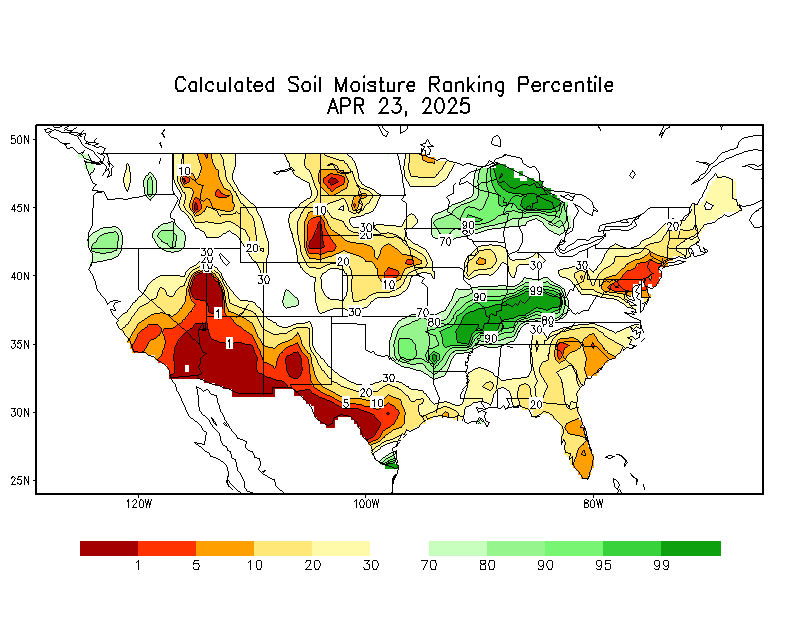
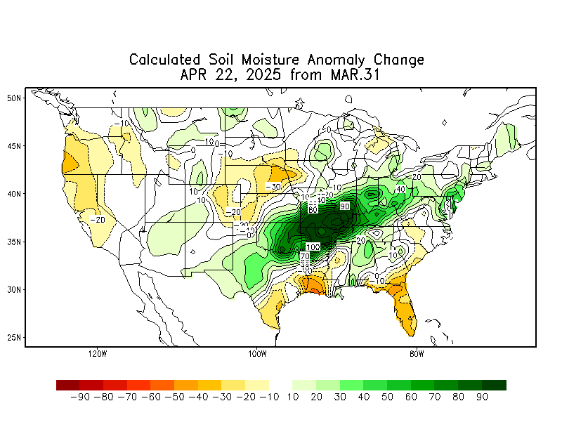
Soilmoisture anomaly:
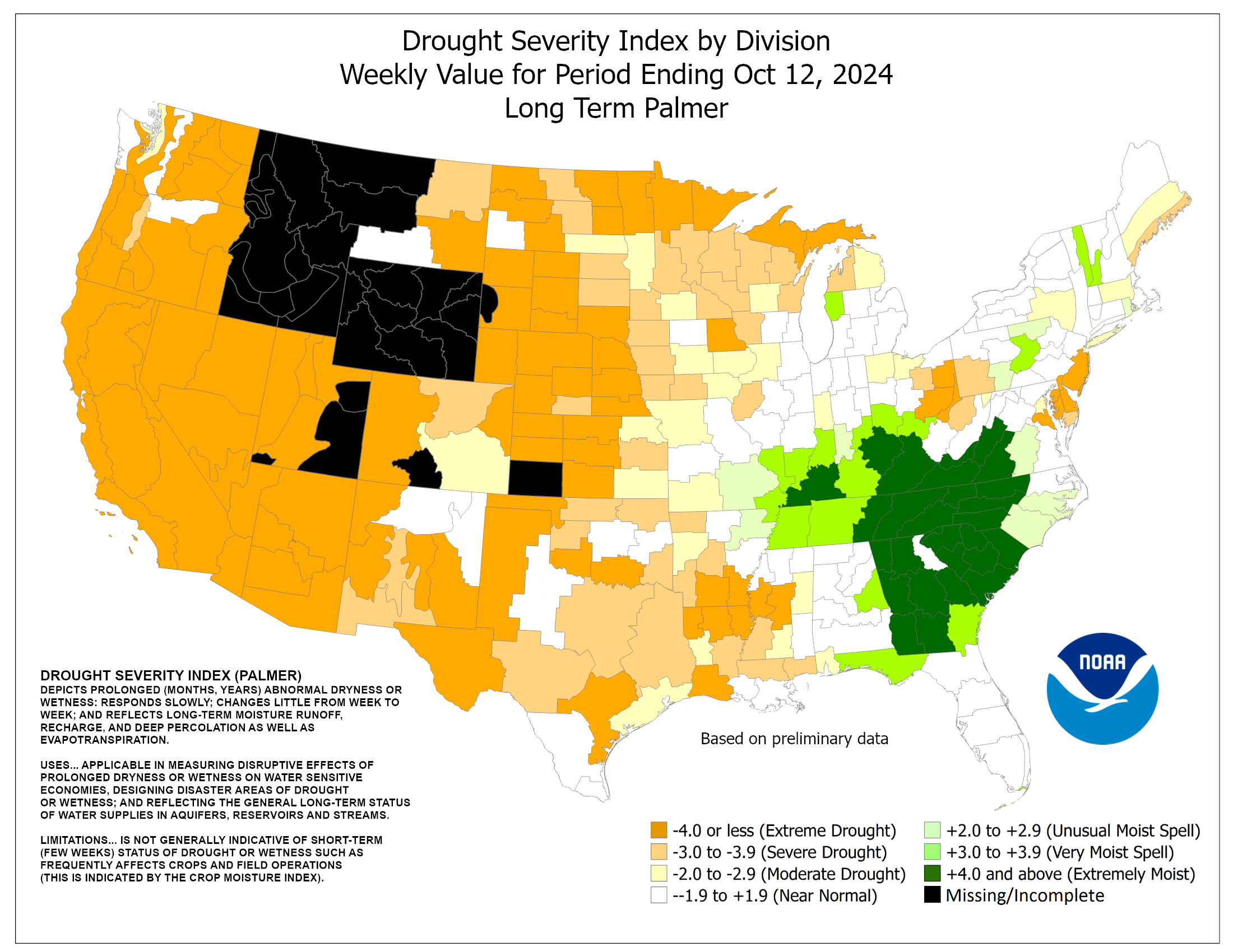
These maps sometimes take a day to catch up to incorporate the latest data(the bottom map is only updated once a week).
https://www.cpc.ncep.noaa.gov/products/Soilmst_Monitoring/US/Soilmst/Soilmst.shtml#

U.S. Drought Monitor
https://droughtmonitor.unl.edu/Maps/CompareTwoWeeks.aspx
TOP Map is Sept 7. Bottom map is the last one, March 29, 2022.
Drought Improves in the Upper Midwest, N.Plains and West.
Drought expands in S.Plains!!
Wet in the Eastern Cornbelt!!!

MARCH 29, 2022 BELOW

december 17: Just updated weeks 3-4 forecast that goes out to Janurary 14th......extremely mild in the south, cold North and West.
https://www.cpc.ncep.noaa.gov/products/predictions/WK34/


EXTENDED WEATHER DISCUSSIONS BELOW
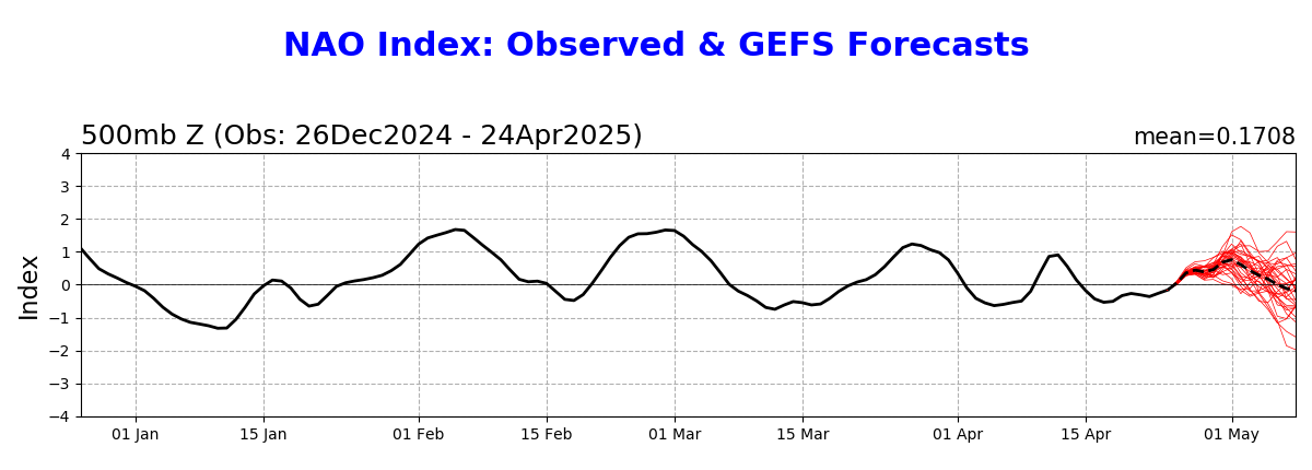
12-19-21: The NAO and AO crash to solidly negative(with alot of spread/uncertainty-PNA heads towards 0 late in the period) which is favorable for cold air to move from north to south from higher latitudes to the middle latitudes.
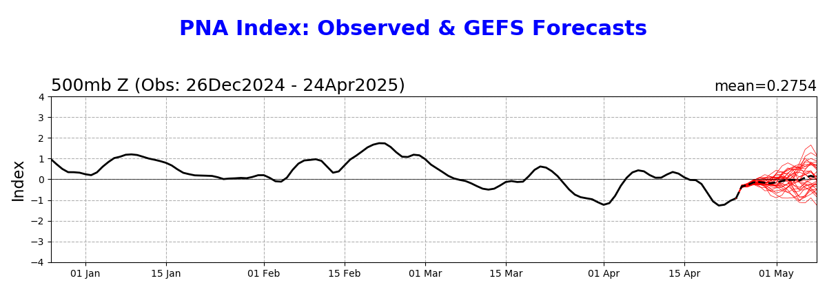
12-22-21: Every day for the past 3-4 days has seen a HIGHER AO and HIGHER NAO. Now, they both go to 0, which is neutral. In fact, the NAO does NOT take the huge dive into negative territory, it stays near 0. The AO has a very wide spread. The PNA stays solidly negative which extremely favors the cold in the West(not the East).
12-23-21: No changes. Not as cold as 4-5 days ago.
12-26-21: Extreme cold NorthCentral to Northwest. Very mild Southeast.
Solidly negative AO brings frigid air from Canada south. Near 0 NAO makes it hard for it to penetrate to the Southeast US.....we need a -NAO for that. -PNA favors cold in the West but it increases at the end of the period, suggesting the cold could push farther southeast.
12-30-21: Huge changes in the indices. AO has numerous positive members that would make it unfavorable for cold to move from high to mid latitudes.......but a wide spread with some still negative and favorable for cold. NAO is positive but dips to 0 briefly. This will make it tough for cold to penetrate deeply into the Southeast. The biggest change is the long lived solidly negative PNA gets back to 0, with moderate confidence. This will cause the West to warm up from the recent extreme cold.
12-31-21: Very similar to yesterday. WARMING WEST! Farther east very uncertain.
1-3-22: Happy New Year. Indices are still not very favorable for sustained extreme cold air in the Midwest/East. But there is uncertainty because of the potential PNA pattern change.
1-4-22: Indices at the end take a turn towards being slightly more favorable for sustained cold but are still only near 0 and thats at the very uncertain end.
1-5-21: AO and NAO now drop below 0 at the end of 2 weeks. More favorable for cold now.
1-6-21: Exact same, outlook as 1-5. AO/NAO moving colder. Some graphs/maps below did not update today.
1-11-12: indices lean cold with wide spread on AO
1-14-22: Almost off the charts spread in AO. NAO close to 0(neutral). PNA is positive. Late week 2 has been looking LESS cold the last 2 days but still COLD.
1-15-22: Indices still favor cold. AO colder today mainly because not as many +AO members as yesterday. Still a wide spread. NAO close to 0 with wide spread. Solidly +PNA drops to 0 at the end......might try to oppose cold farther east?
1-19-22: Indices have shifted to taking out cold risks. Both AO and NAO now go solidly positive with good agreement. PNA drops to negative which shifts cold risks farther west and helps warm the east/downstream.
1-20-22: Same as yesterday with a very wide spread for the AO.
1-22-22: AO spread is huge and added some extreme negatives(cold). NAO drifts lower late in the period, potentially colder than yesterday. PNA dropping, favoring the cold in the West.
1-31-22: AO and NAO are positive and not favorable for widespread extreme cold. NAO dropping a bit late. +PNA morphs to near 0.
2-2-22: AO has the most extreme spread possible.......a couple of solutions ++++AO, 1 solution -----AO. NAO also a wide spread.
2-7-22: +++AO reduces that the chance of cold air moving from high latitudes to the mid latitudes to extremely low. +NAO reduces the chance of cold penetrating very far south in the eastern US to minimal. PNA drops to near 0.
2-8-22: ++AO and +NAO make sustained major cold unlikely.
2-11-22: Not much change. AO and NAO drift a bit lower late......but that doesn't seem significant right now.
2-13-22: Same as previous
2-15-22: Still not favorable for widespread, sustained cold movement from high to mid latitudes. But the anomalies below these indices HAVE turned MUCH colder.
2-21-22: Interesting that these indices(AO/NAO) have never turned very cold(though dropping a bit towards the end of the period) but the anomalies below show a very strong cold air couplet for the US!
2-27-22: Indices (AO/NAO) morph towards 0/neutral. PNA is dropping to negative.......favors cold in the West to Plains.
2-28-22: Indices a more positive/milder today(AO/NAO). PNA solidly negative favors cold/West, warm/East.
3-2-22: Indices not that cold but the pattern pattern is.......see below.
3-3-22: AO: extremely wide spread. NAO: wide spread, slightly positive. PNA: solidly negative. Favors cold in the West but the actual pattern below likes the cold farther east.
3-6-22: AO: Wide spread, morphs positive late. NAO: a bit positive(mild). PNA: Solidly negative means favors cold in the West.
3-7-22: Similar to 3-6-22!
3-28-22: AO and NAO INCREASING in week 2 suggesting milder weather.
++++++++++++++++++++++++++++++++++++++++++++++++++++
https://www.cpc.ncep.noaa.gov/products/precip/CWlink/daily_ao_index/ao.shtml
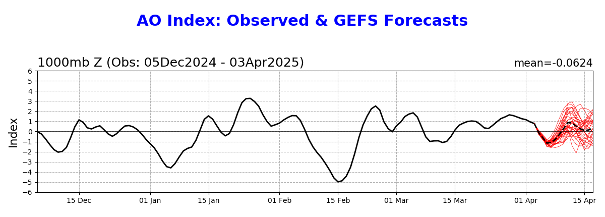
https://www.cpc.ncep.noaa.gov/products/precip/CWlink/pna/nao.shtml
https://www.cpc.ncep.noaa.gov/products/precip/CWlink/pna/pna.shtml
++++++++++++++++++++++++++++++++++++++++++++
https://www.psl.noaa.gov/map/images/ens/t850anom_nh_alltimes.html
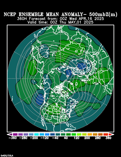
12-19-21: This is the 500mb anomaly below at the end of the period....15 days.... from the GFS ensemble mean. All the anomalies and teleconnections are favorable for cold air delivery into the US.
12-22-21: COLD WEST with extremely high confidence. Very mild Southeast with moderate confidence.
12-=23-21: No changes.
12-26-21: Cold may get a bit better low level push southeast but the positive heights in the Southeast will try to resist.......with the resistance weakening in week 2.
12-30-21: Tremendous change in the anomalies out West. Going from the very strong/deep negative anomaly to a positive anomaly. Lots of change and movement and uncertainty in the East.
12-31-21: Anomalies NOT favorable for cold air to move from high latitudes to low latitudes............but amplification of the Western ridge/positive anomaly could change that. Warmest temps shift to the WEST........high confidence!
https://www.marketforum.com/forum/topic/78991/#79687
1-3-22: The anomalies at 360 hours have been moving around so much recently that I wouldn't put much weighting on today's model guess!
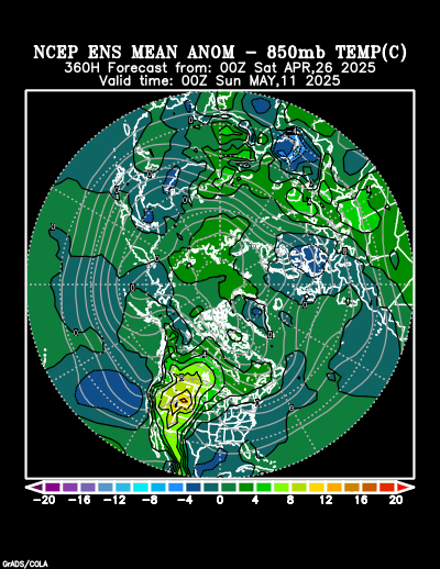
1-4-22: This is the solution from the 0Z run of the GFS ensemble. The anomalies look favorable on this run for some major cold to hit the high population areas of the US. The European model was actually MILDER on the same run. Much uncertainty.
1-5-22: Ridge Alaska/Trough near N.Plains is a nice POTENTIAL cold air delivery couplet. Uncertainty is high.
1-6-22: Favorable ridge/positive anomaly/Alaska, trough downstream along the Canadian border for cold delivery.
1-14-22: Still favorable ridge/positive anomaly/Alaska/western North America to Siberia and trough/negative anomaly downstream in eastern North America..favorable for cold air delivery that is!
1-15-22: Very similar to previous week+. One new element recently is that half of the ensembles are trying to fill in the upper level trough in the East and create more zonal flow. Those solutions looked more impressive on Thursday, which is maybe why ng gave back all the gains from the previous day.
1-19-22: Large scale pattern and anomalies are retrograding(moving west). Cold that had been targeting the Midwest/East........"backs up" and is targeting the West with the East warming up.
1-20-22: Really warming up in the East and cooling off in the West. Back to the December pattern.
1-21-22: Some extreme cold...coldest on the planet in West/Central Canada. Target looks like the northwestern 1/3 to 1/2 of US while it stay mild in the southwestern 1/2 of the US. Very similar to December and what a typical La Nina causes.
1-31-22: Positive anomaly off the West Coast of North America and negative anomaly in Eastern Canada to the Upper Lakes is very favorable for Midwest to Northeast cold, especially along the Canadian border.
2-2-22: POWERFUL couplet! Positive anomaly off the coast of North America and strong negative anomaly downstream into the Midwest...perfect for frigid air transport from Canada.....especially into the Midwest.
2-7-22: Anomalies have greatly shifted the last 5 days. Positive anomaly in the West favors warmth there and also Southeast. Negative anomaly in Northeast Canada is pretty far away but could allow brief intrusions of cold in the Northeast(+NAO is against that, however)
2-8-22: Big shift in the anomalies. Positive across most of the US means widespread mild temps later this month.
2-11-22: Same solution all week. Extremely mild.
2-13-22: Exact same as previous
2-15-22: Anomalies above on 500 mb map/jet stream map have shifted to colder! Positive in northwestern North America with downstream negative in eastern Canada with a 500 mb trough well in the Midwest has cold air delivery potential!
2-21-22: This very strong cold air couplet has remained now for the past week, as indicated on the 2-15-22 update above. Very Powerful Positive anomaly from the far Northeast Pacific to Alaska, across Northwest Canada extending to the North Pole and N.Siberia with a negative anomaly downstream from E.Canada, across the N.USA.
2-22-22: Upper level positive in the Southeast is more pronounced today.........LESS cold.
2-27-22: Positive in the Southeast. Decent cold air couplet in the high latitudes. Positive Northeast Pacific to Alaska. Strong negative downstream in Eastern Canada extending to Upper Midwest. Some of that cold should push south of the US border.
2-28-22: Positive in the Southeast has expanded. Negative in Eastern Canada has strengthened BUT SHIFTED FARTHER EAST/MOVED AWAY (breaking it away from the stronger couplet flow connection/relationship from the upstream positive back in the Northeast Pacific/Alaska) but still has a trough back to the US border.
3-2-22: Trough in Eastern Canada deepens in Midwest/East sending down cold from high latitudes.
3-3-22: Deep negative/trough in Eastern Canada with positive just west of Alaska and cross polar flow in between this couplet will drive frigid air thru Canada, aimed at the Northern USA. Positive/ridge trying to build in the Southern US, trying to resist that.
3-28-22: Positive anomalies growing stronger in the South! and expanding.
https://www.psl.noaa.gov/map/images/ens/z500anom_nh_alltimes.html
Models and indices are even milder at the end of 2 weeks today!
+AO, +NAO and -PNA very unfavorable for cold air delivery into the US at the end of the period!
12z models this morning were COLDER.
Very mild outlook for week 2!
Still very mild for December the next 2 weeks. Precip chances increasing in week 2.
Still extremely mild in week 2!
Some of the frigid weather in Canada sneaks south of the border!
As you and the ensemble means keep showing, it continues to look quite mild out two weeks while the MJO allows for the zonal flow to continue. The question continues to be when the MJO will finally shift enough left in the diagram to allow what models have been showing to be a pretty large area of the coldest on the globe persisting in W Canada next week to later bodily come down into the US. The ante is very high on the potential for a very sharp change from quite mild to potentially frigid cokd to dominate starting in about two weeks central US and about 3 weeks E US and then going at least for several weeks. The CFS (essentially an extension of GETS) is a model with very low credibility as I like to say since it looks out so far, but unfortunately one has to look out that far for any possible hints of potential cold to actually plunge well down into a good portion of the US. Fwiw, it has been suggesting that possibility on some runs.
Agree Larry!
There looks to be a pretty good chance for turning colder at the end of the 2 week period and Canada will be loaded with frigid air as you mentioned.
So any model runs that update showing a strong cold front from Canada penetrating deeply south vs previous runs will add double digit HDD's and be pretty bullish at that time.
However, the bottom will be in, not from a model run suddenly showing an individual cold shot thats much colder but from the shift in the configuration of the large scale features that allows more sustained cold coming south from Canada.
That might start with an individual stronger cold front.
Also, cold dense air moving south out of Canada is often not handled well by the models. It frequently is able to undercut warmer air aloft and an upper level pattern that looks warm but the shallow very cold air near the surface goes hundreds of miles farther south than the models thought that it would.
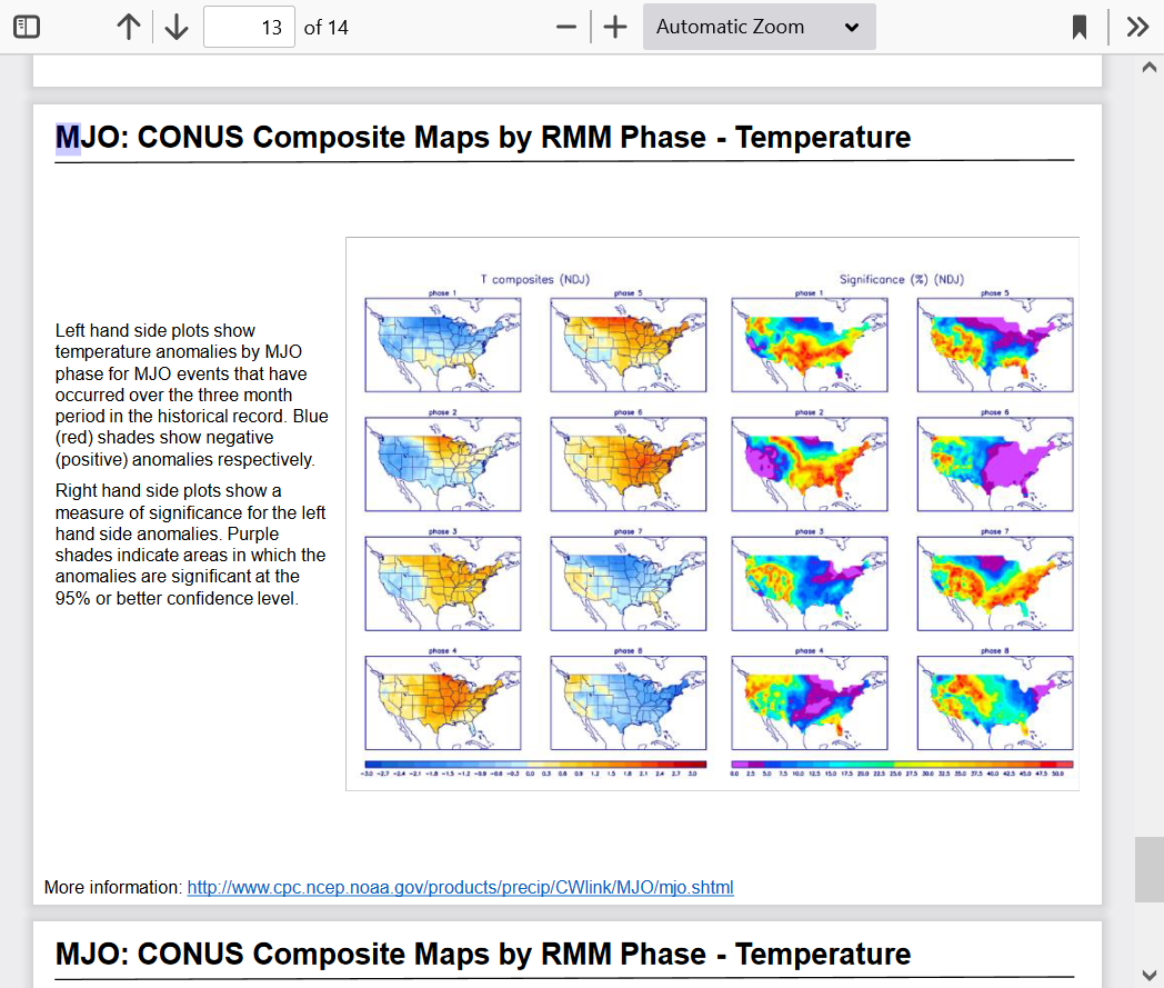
Latest MJO forecasts continue to suggest high potential to go from the current phase 6(which historically has WARM analogs for much of the US) to phase 7 in around 2 weeks.........which flips to cold analogs, especially in the middle of the country. A continuation to phase 8 by early January would push the cold even farther east.
Madden-Julian Oscillation: Recent Evolution, Current Status and
Predictions
Update prepared by the Climate Prediction CenterClimate Prediction Center / NCEP
6 December 2021
https://www.cpc.ncep.noaa.gov/products/precip/CWlink/MJO/mjoupdate.pdf
Weather models, today outside of the potential MJO influence show no signs of the current mild weather regime changing at 2 weeks.
The weather headline on Thursday is the enhanced potential for severe storms late Friday/Friday Night that included rotating storms that turn into strong tornadoes!
More on this later today!
New weather thread updating on developing severe weather outbreak threat:
https://www.marketforum.com/forum/topic/78838/
Weather update post on extended forecast for natural gas traders:
Some pretty good precip coming up for drought areas of the West Coast:
Severe storms with the current system in the upper Midwest with with surface low, jet stream and upper level dynamics shifted around 800 miles farther northwest of the one late last week.
Severe weather is unlikely when this system comes thru as a cold front in the areas hit by the tornadoes last week.
https://www.marketforum.com/forum/topic/78385/#78390
+++++++++++
Look how deep the low pressure storm is!
https://www.spc.noaa.gov/exper/mesoanalysis/new/viewsector.php?sector=13#

See the latest extended wx discussion on the MJO here:
The pattern is setting up to turn into a cold northern US, warm southern US regime as the month goes with tremendous uncertainty on how far south the cold will go.
A slight shift north or south will mean a huge difference in temperatures for areas in the tightest part of the temperature gradient.
Confidence in major cold along with the polar vortex shifting pretty far south at the end of december And intensifying in early January is going way up!
Stay tumed.
Early January is shaping up to be extremely cold in the US!
6Z and 12Z Sunday models were all much milder than the previous runs after being colder for several solutions.
Same basic pattern,
except the temperature bands all shift north 100+ miles and the temp gradient is so tight with this pattern, that it makes a difference of 10 HDD's.
All the weather is here........warm week coming up for the southern 2/3rds. No White Christmas this year!
Then, turning sharply colder.......but how cold in early January?
https://www.marketforum.com/forum/topic/78385/#78399
Latest MJO discussion.
Signal appears to be weakening.
https://www.cpc.ncep.noaa.gov/products/precip/CWlink/MJO/mjoupdate.pdf
Latest week 2 analysis here:
Just Updated the key factors for week 2 weather here for you:
Latest update for 12-26-21
https://www.marketforum.com/forum/topic/78385/#78399
Frigid air Northwest to NorthCentral this week.......very mild Southeast but the low level cold bleeds farther and farther south,....and east....especially in week 2.
Latest MJO discussion:
https://www.cpc.ncep.noaa.gov/products/precip/CWlink/MJO/mjoupdate.pdf
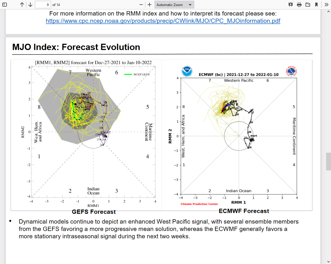
• Both velocity potential based MJO and RMM indices indicate an active West Pacific MJO event with little continued eastward propagation in recent weeks.
• There is disagreement among the dynamical models regarding the predicted evolution of the MJO, leading to continued uncertainty in the outlook.
• Tropical cyclone formation is favored over the southern Pacific where any coherence of the MJO is more likely to manifest itself during the next two weeks.
• While West Pacific MJO events typically favor colder than normal conditions across the CONUS, extended range model guidance continues to mimic more of an amplified negative Pacific North American pattern, suggestive of La Niña dominating the extratropical response over North America.
Updated the snow forecast:
Week 1 features the frigid air in West to the Plains shifting eastward but moderating a great deal in the process.
Week 2 is a continuation of that shift but with a pattern change that starts a massive warm up out West and the brand of cold hitting the East being modest.
https://www.marketforum.com/forum/topic/78385/#78399
Same forecast philosophy today! https://www.marketforum.com/forum/topic/78385/#78399
Most of the other maps above are updated constantly.
Will start a new weather thread this week.
This one is still being updated.
Frigid temps currently. Latest longer term outlook at this link: https://www.marketforum.com/forum/topic/78385/#78399
Current snow event along and south of Ohio River.
Snow to water equivalent
Started by metmike - Jan. 5, 2022, 11:51 p.m.
The upcoming snow here in Evansville IN and just south is going to be unusually dry because the temperature will be around 20 deg. F (and colder air holds much less moisture). https://www.marketforum.com/forum/topic/79941/
Lastest MJO discussion. It SHOULD be causing cold in the US the next several weeks under normal circumstances.
https://www.cpc.ncep.noaa.gov/products/precip/CWlink/MJO/mjoupdate.pdf
• MJO propagation has stalled near the Date Line, likely due to the destructive interference with La
Niña.
• Dynamical models exhibit large spread regarding the evolution of the MJO over the next 2 weeks,
with a meandering intraseasonal signal depicted in the GEFS and ECMWF ensembles.

The MJO is in and going to a state that historically causes the greatest cold influence in the US......phase 7 going to phase 8.
I just talked to a meteorologist at CPC about the lack of teleconnection indices the last two days. Here is an email I sent him for documentation (he asked me to do this) and which summarizes the problem:
“Thanks for calling me back. I'm sending you this email as documentation of what I called you about. The normally daily updated PNA, AO, NAO, and MJO have not updated the last two days. I monitor these daily and was calling to find out the problem. I don't recall ever seeing two days in a row of no updates. You told me that it was based on an NCEP system issue and that it should be resolved by Sunday or Monday.
I'm not a meteorologist but have learned a lot and do follow weather every day as a hobby.
If you have any further updates, please feel free to email me.”
Larry, no where else could I/we receive extremely useful information like that.
I very grateful to you. Was wondering the exact same thing and noted the absence of that data on my updates yesterday(which is likely why you pointed this out for us).
Thanks a ton! You're the best!
Even BETTER than most meteorologists when it comes to tracking weather and how it affects natural gas, cotton, coffee and hurricances!!!
Not saying that just to make you feel good.........it's a rock solid fact!
Weathermen
Please begin a new "gas" post sunday afternoon.
I bought a feb call based upon my cycle work which was reinforced by your combined "colder" forecasts winning out over warming posts.
Wednesday I had hope, Thursday I was disappointed, but today optimistic.
MetMike, you have noted to the Forum that I approach highly speculative WEATHER trades with options. YES, I pay premium, but loss is defined AND the contemplated reward seems justified. One win usually pays for 3 attempts.
Again, frustrating wipsaw week---draw down
i hear you tjc...very frustrating spikes up and down this week but the trend has been up/colder late week 2.
Just added this snow graphic/info:
Still looking pretty cold the next 2 weeks, especially Midwest to northeast.
0z European model was especially cold overnight.
Snow event coming up
Started by metmike - Jan. 13, 2022, 2:17 a.m
Updated extended large scale anomalies/indices.
Updated extended discussion/maps:
Updated Winter Storm:
Updated Extended analysis:
Latest MJO discussion from earlier in the week:
https://www.cpc.ncep.noaa.gov/products/precip/CWlink/MJO/mjoupdate.pdf
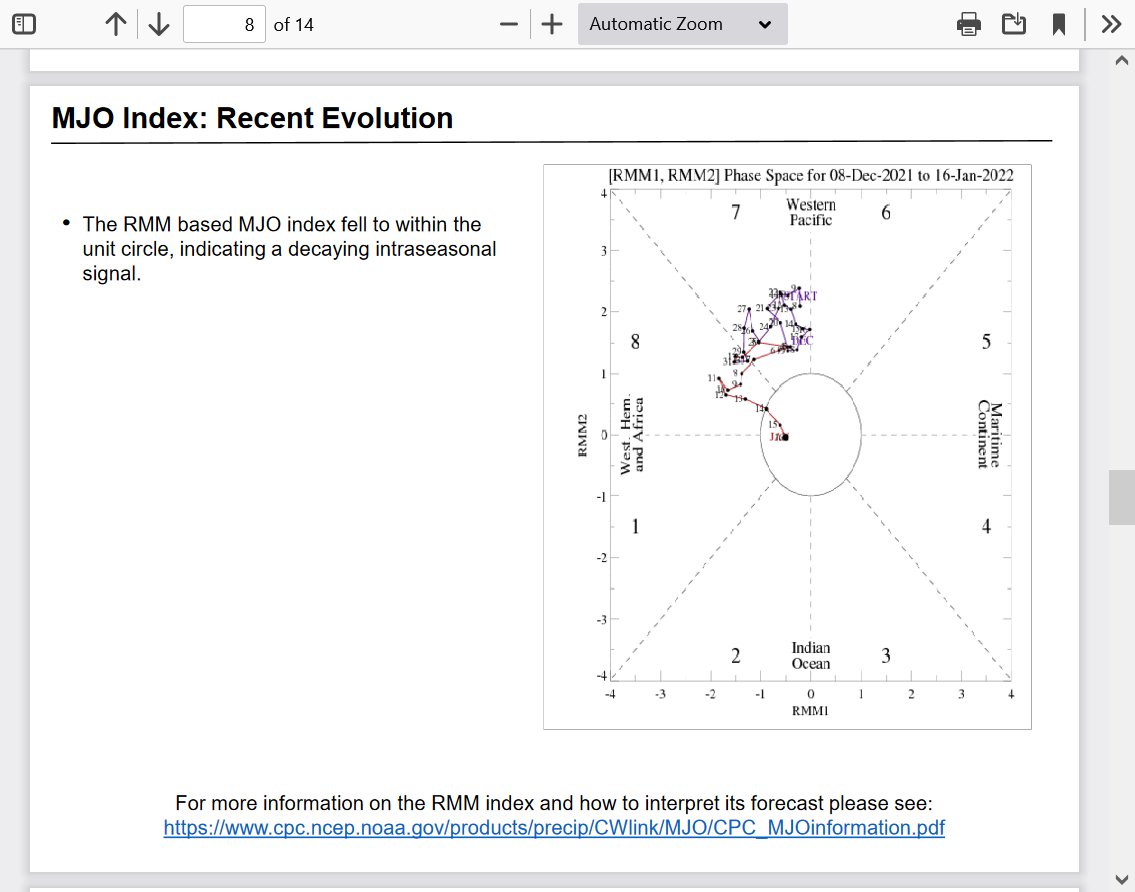
• Following a period of renewed eastward propagation earlier in January, the RMM index indicates
the MJO has lost much of its amplitude, falling within the unit circle during the last week.
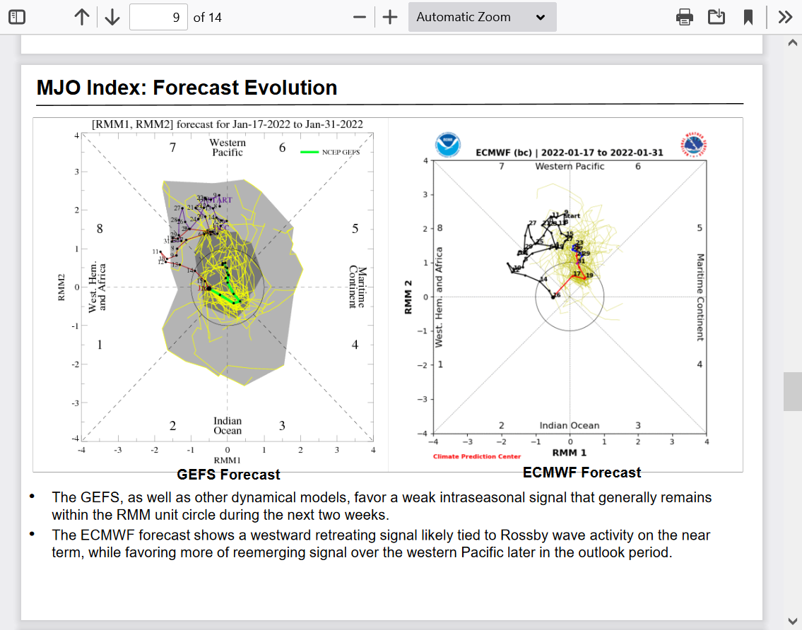
• Dynamical models generally show the MJO remaining weak and incoherent as other modes of
tropical variability are favored to prevail over the Indian Ocean and Pacific through the end of
January.
Confidence in the extended(week 2 part of the forecast) is about as low as it gets right now!
https://www.marketforum.com/forum/topic/78385/#78398
https://www.marketforum.com/forum/topic/78385/#78399
NWS forecast philosophy/reasoning. They are confidence as a 1 out of 5!
https://www.cpc.ncep.noaa.gov/products/predictions/610day/fxus06.html
Following the close call OJ freeze thanks to hayman:
Huge snow amounts left in the Northeast!
https://www.marketforum.com/forum/topic/81027/
New big snow next week: MO/IL/IN/OH/se MI:
https://www.marketforum.com/forum/topic/78385/#78391
1-30-22 Huge Snow/ICE coming this week!
9 responses |
Started by metmike - Jan. 30, 2022, 2:01 p.m.
Updated extended guidance analysis of tools:
Updated extended:
Updated extended.....even milder today!
Extended the same as the last week:
https://www.marketforum.com/forum/topic/78385/#78399
Snowfall map updated:
Extended week 2(500 mb anomalies) is sharply LESS mild Midwest and northeast.
https://www.marketforum.com/forum/topic/78385/#78399
Most of the actual maps are updated constantly above.......with a link provided to go to that source.
Snodgrass latest has some good news for very dry northern plains to get percep. There still is a large blocking high out in then Atlantic.
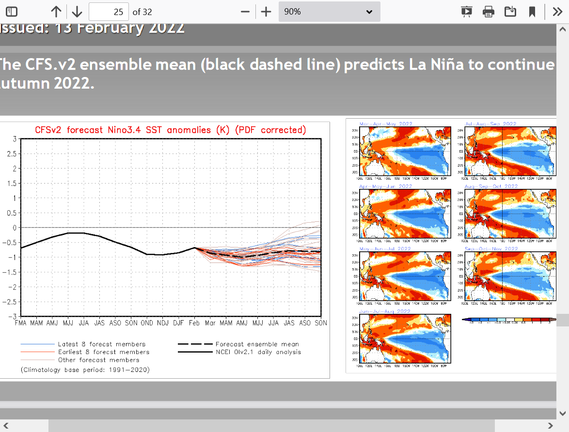
We still have a global cooling La Nina that means elevated chance of the drought getting worse.
Global warming and El Nino's always increase the odds for favorable weather the most.
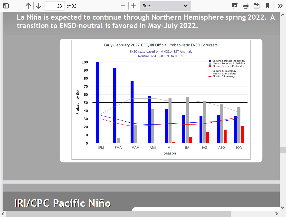
Some models morph the ENSO to neutral, some keep us in La Nina (CFS) thru the growing season. El Nino chances are unlikely thru the rest of the year.
ENSO: Recent Evolution,
Current Status and Predictions
Updated extended.........still very cold:
Extended not nearly as cold the last 24 hours.
https://www.marketforum.com/forum/topic/78385/#78399
Winter weather page updated:
New Winter weather threat 2-23-22
8 responses |
Started by metmike - Feb. 23, 2022, 12:43 p.m.
Updated extended worded description:
https://www.marketforum.com/forum/topic/78385/#78399
Winter weather update:
https://www.marketforum.com/forum/topic/78385/#78391
Most of the other maps update constantly!
Extended still VERY mild for the high population centers in the East and Midwest.
All eyes will be watching the Plains/Midwest for potential drought busting rains.........or drought amplification before the growing season with old crop supplies of all the grains critical and dire need for a HUGE new crop in the US.
Nothing big the next week where we need precip the most!
The first crop rating could be the worst ever for the HRW crop!
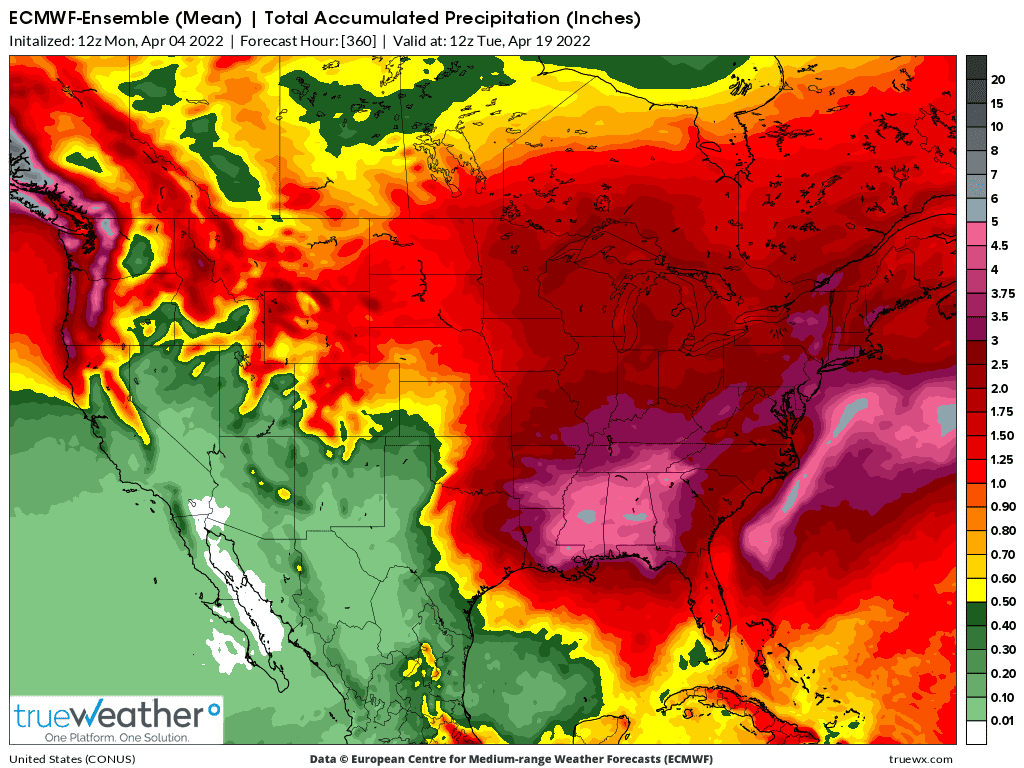
2 week precip forecast from the last European model:
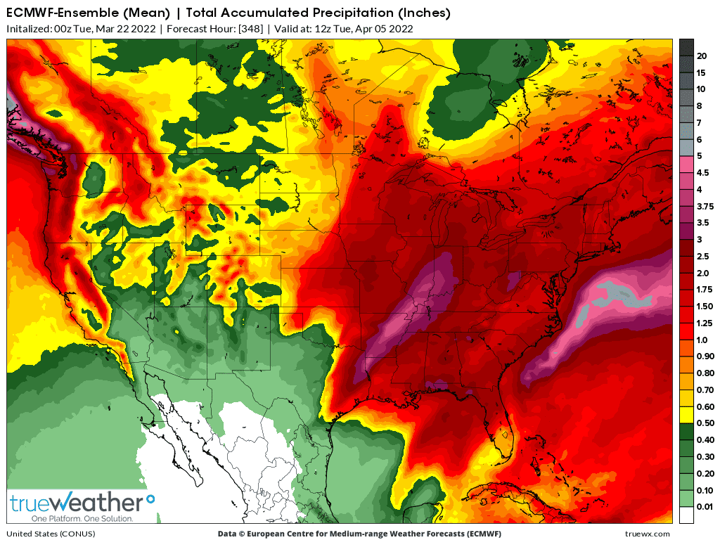
We have the wrong pattern in place to break the drought. Ideally, an upper level ridge along the East Coast to pump in rains and trough WEST of the Plains.
7 day rains:
https://www.marketforum.com/forum/topic/78385/#78388
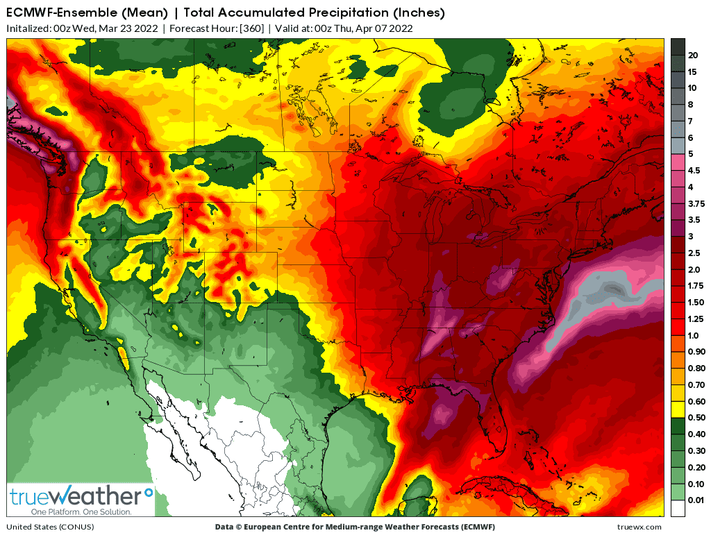
2 week rains:
Latest seasonal forecast(extremely bullish)
Updated extended worded description:
Watching the drought area of the Plains for needed rains for the HRW crop!
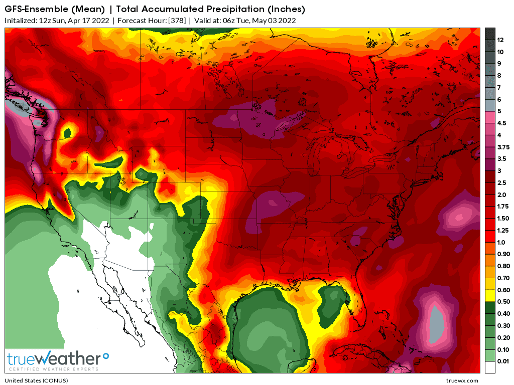
Rains staying east of the driest areas on the latest 2 week, GFS ensemble forecast, European below that
The extreme dry areas are in the Plains!
The ECB to south are MUCH too wet!
Here is IN, I had to use a weed eater to cut large, low lying areas of my lawn with sloshy ground unable to support any sort of mower.
https://www.cpc.ncep.noaa.gov/products/Soilmst_Monitoring/US/Soilmst/Soilmst.shtml#

Below is where the precip will be the next 2 weeks. Driest areas still miss the best precip but some could hit eastern parts of the very dry HRW belt.
Shifting these lower Midwest rains 400 miles west, into NE/KS/OK/TX would take $1 off of wheat in a flash, possibly -$2.
The SRW needs DRY weather!
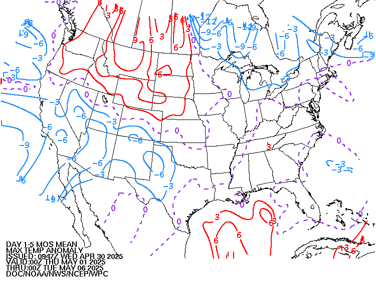
Along with the driest spots missing most of the rain, there is some heat coming there too this week:
https://www.marketforum.com/forum/topic/78385/#78393
Highs for days 3-7:
https://www.wpc.ncep.noaa.gov/medr/medr_max.shtml

The week 2 part of the forecast is also looking bullish there:
https://www.marketforum.com/forum/topic/78385/#78395
| 8 to 14 Day Outlooks | |
| Click below for information about how to read 6-10 day outlook maps Temperature Precipitation | |
| Click below for archives of past outlooks (data & graphics), historical analogs to todays forecast, and other formats of the 8-14 day outlooks ArchivesAnalogsLines-Only FormatGIS Data | |
Temperature Probability | |
Precipitation Probability | |
It's going to be almost impossible to give all the crops good weather for the next month because we have conditions and needs that are exactly the opposite across the cornbelt right now.
Any big rain makers that help the bone dry HRW crop will cause planting delays for corn farther east.
Warm and dry weather needed to get corn planting going, will hurt the HRW crop that needs rain.
If the upcoming pattern for the next month is similar to recent weather (too dry west, too wet east) it will exacerbate the current extreme conditions.
This is the latest 2 week precip forecast from the last 0Z European model.
Too much rain in many places that want to get planting started(temps also chilly). Some of that rain will hit the eastern part of the very dry HRW/S.Plains belt to help the Hard Red Winter Wheat crop.
Latest 2 week precip from the 12z GFS ensemble mean today: