Scroll down for numerous updates the next several days!
Weather map now.
In 24 hours and
In 48 hours.
https://www.wpc.ncep.noaa.gov/#


+++++++++++++++++++++++++++++++++++++++++++++++++++++++++++++++
Though I'm constantly alerting people to upcoming weather changes, which sometimes means the threat of tornadoes(this one has a low threat of violent/killer tornadoes for Indiana ) we should always put it into perspective and not let excessive fear of severe weather cause stress in our lives!
Tornadoes vs drug over dose and suicide deaths and car crashes
Started by metmike - April 21, 2022, 11:26 p.m.
https://www.marketforum.com/forum/topic/83578/
Severe Storm Risk......updated at least once/day!
https://www.spc.noaa.gov/products/outlook/
Current Day 1 Outlook | |
Current Day 2 Outlook | |
Current Day 3 Outlook | |
Current Day 4-8 Outlook |
Excessive rain threat.
https://www.wpc.ncep.noaa.gov/qpf/excess_rain.shtml
Current Day 1 Forecast
Day 1 Threat Area in Text Format
Current Day 2 Forecast |

The latest precip forecasts for the next week are below.
Day 1 below:
http://www.wpc.ncep.noaa.gov/qpf/fill_94qwbg.gif?1526306199054

Day 2 below:
http://www.wpc.ncep.noaa.gov/qpf/fill_98qwbg.gif?1528293750112

Day 3 below:
http://www.wpc.ncep.noaa.gov/qpf/fill_99qwbg.gif?1528293842764

Days 4-5 below:
http://www.wpc.ncep.noaa.gov/qpf/95ep48iwbg_fill.gif?1526306162

Days 6-7 below:
http://www.wpc.ncep.noaa.gov/qpf/97ep48iwbg_fill.gif?1526306162

7 Day Total precipitation below:
http://www.wpc.ncep.noaa.govcdx /qpf/p168i.gif?1530796126

Tracking the storm!
Current Conditions below updated every few minutes.
https://www.spc.noaa.gov/exper/mesoanalysis/new/viewsector.php?sector=13#


https://www.spc.noaa.gov/exper/mesoanalysis/new/viewsector.php?sector=20


https://www.spc.noaa.gov/exper/mesoanalysis/new/viewsector.php?sector=20#

Most maps below are constantly updated
Latest National radar images
https://www.wunderground.com/maps/radar/current

This link below provides some great data. Hit the center of the box below for the area that you want, then go to observation on the far left, then surface observations to get constantly updated surface observations.
 |
Local weather information from the NWS in Paducah that includes the Evansville IN area of responsibility:
Local NWS for Evansville Indiana:

Hourly weather graph:
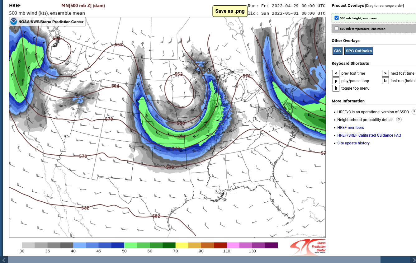
This is the 500 mb forecast(at 18,000 feet/over 3.5 miles) for Saturday Evening(the time of max risk for Indiana):
https://www.spc.noaa.gov/exper/href/
The dark green is an almost 70 knot speed max(~84 mph) jet streak.
Moderately strong but the last severe weather event on April 13th had a jet streak of 150+ mph at 35,000 feet up. This was why strong/violent tornadoes were a very possible threat with that event.
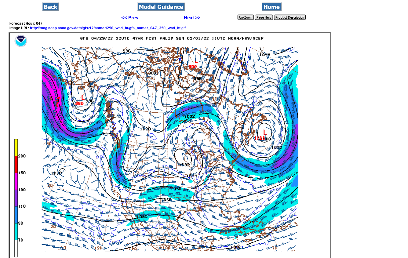
Isolated weaker tornadoes will be a threat this time but more so from severe thunderstorm winds and a slight risk of that.
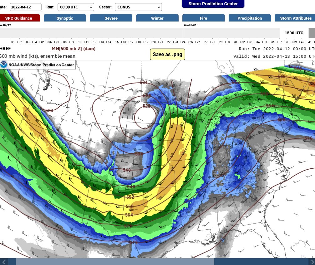
Below is what the 500 mb map looked like from that event on April 13th. Waaaaay more powerful jet stream winds then vs this time!
https://www.spc.noaa.gov/exper/href/
These were the winds even higher up with that event. A jet streak Roaring at 150+ mph in Indiana! This is needed for the most violent tornadoes!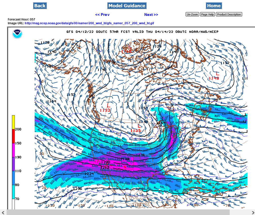
This weekend, a similar map for the upper level jet stream below has around 70 knots/85 mph for Indiana....almost 50% less powerful as April 13th!!! Tornadoes this time are less likely and would probably be weaker tornadoes.
https://www.spc.noaa.gov/products/outlook/day2otlk.html
Threat below for high winds 15%(within 25 miles of any location in that shaded area).
these maps will advance and be outdated

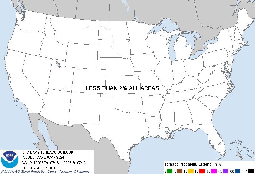
Threat for tornadoes at 2% (within 25 miles of any location in that shaded area)
Threat for hail is 15% within 25 miles of any location.
While we have your weather attention, this is the just updated Summer weather outlook:
NEW: La Nina/-PDO with latest Summer Forecast 4-26-22
23 responses |
Started by metmike - April 26, 2022, 6:59 p.m.
https://www.marketforum.com/forum/topic/83698/
The awesome Severe Storms Forecast Center has updated/fine tuned their assessment for this afternoon based on exact details that are more clear to pinpoint a specific, small area of MODERATE risk. This includes a 45% chance of a severe thunderstorm wind within 25 miles in that area and 15% chance of a tornado.….. in the Plains. While it can't be ruled out, the vertical wind profile is NOT favorable for a violent, 200 mph tornado, the kind that kills the most people.
https://www.spc.noaa.gov/products/outlook/day1otlk.html

They just updated their day 2 product and left most of it the same. The higher risk of severe storms and tornadoes will be towards Chicago in IL and even there, it's not the signature of an outbreak of violent tornadoes.....though we should always take the precautions to maximize safety and minimize REAL threats like this!
Current Hazards at the link below.
Go to the link below, hit hazards box in the top right hand corner(it will also define all the color codes), if its not already in the hazards mode when you load the link.
Then you can hit any spot on the map, including where you live and it will go to that NWS with all the comprehensive local weather information for that/your county.

Since we are discussing a potential tornado threat with this system, here's a rarely stated massive benefit to climate change regarding tornadoes.
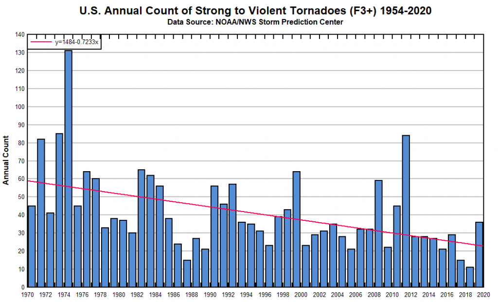
Individual tornadoes each year and each system are just WEATHER. Climate is considered the weather averaged over a period of at least 30 years. Regarding violent tornadoes(200+ mph winds), the ones that kill the vast majority of people......the warming of the coldest places the most (highest latitudes) during the last century has reduced the meridional temperature gradient and reduced the number of killer tornadoes by around 50%.
The highest incidence of violent tornadoes took place in the global cooling years of the 1950s-70's. The spike higher in 2011, was mainly from the La Nina and global cooling affect that year.
https://climateataglance.com/climate-at-a-glance-tornadoes/
Weak tornadoes have increased only because our technology to detect the weak ones that previously were not detected was greatly advanced in the early 1990's from NEXRAD Doppler radars. This, along with an expanded spotter network coverage area.
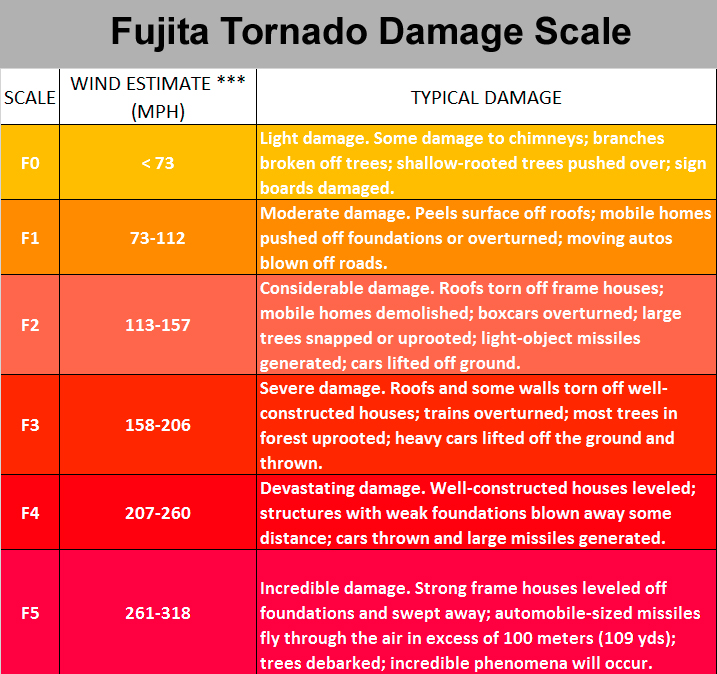
There is no mistaking a violent tornado's path.....technology or no technology!

http://www.tornadoproject.com/cellar/fscale.htm
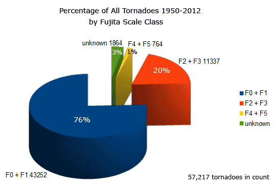
You will note that 76%(most) of tornadoes are "WEAK" tornadoes. They rarely kill people. This is the kind of tornado that is most likely with the current weather situation.
When you get to F2 and F3 tornadoes, they become deadly. This current situation is not likely to produce that kind of tornado.
F4 and F5 tornadoes are very rare (1%) but kill the majority(67%) of people. It would be extraordinarily shocking if we saw this kind of tornado from the current system. We KNOW the conditions that cause them........upper level winds are much too weak right now for an F4 or F5 tornado.
++++++++++++++++++++++++++++++++++++++++++++++++++++++++++++++

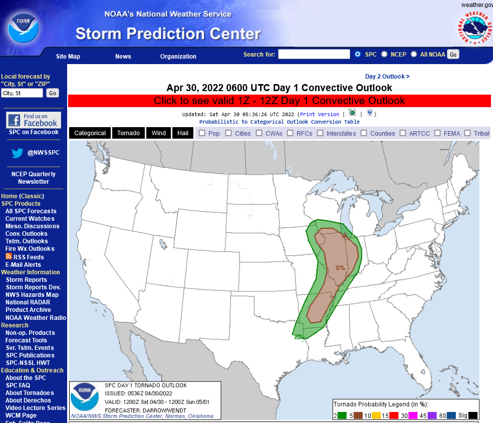
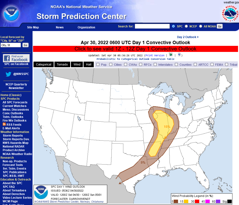
Just updated guidance for Saturday is similar to the previous forecast philosophy but has increased the tornado threat to 5% chance within 25 miles of any location all the way south across the entire slight risk area. 15% chance of a severe storm with 58+ mph winds within 25 miles of any location.
The storms should be weakening well after nightfall on Saturday when they hit Indiana.
https://www.spc.noaa.gov/products/outlook/day1otlk.html
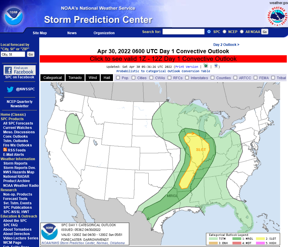
Tornado risk below-5%
Severe Storm risk below-15%
We should one again uderstand the REAL level of risk each time and not treat the risk for mainly F1 or F0 tornadoes, with 100mph winds, like this one...... the same as for F2 or stronger tornadoes with winds of 150+ mph winds.....like the last one was over 2 weeks ago.
We’re smart enough and have the technology to measure and predict the type of tornadoes vs just using the word tornado for every tornado risk and expect people to behave the same way.
What does that actually mean?
It means downplaying risk with weaker events.
it still means going to a safe,place during all tornado warnings but with this current event risk of weak tornadoes, it does NOT mean staying up, hours after bedtime waiting for the event to see if you need to go to the basement.
You should be ok in your upstairs bedroom sleeping if an F0 tornado hits, even if it knocks a tree down and damages your roof.
The biggest exception is mobile homes! You don’t even want to be in there for very strong severe thunderstorm winds as well as weak tornadoes.
However, even in a mobile home park, the honest reality is that the risk of death with an event like this one is minuscule. If you live in a mobile home, the fact is.......YOU LIVE IN A MOBILE HOME and accept the additional risk. That's life.
Staying in a mobile home, even with a high risk of violent tornadoes is sort,of like driving down the highway with nobody in the car wearing a seat belt.
Really, what are the chances of you getting into a high speed car crash on that day?
Minuscule.
But if you do it every day of every year, the number of risk events add up to being significant and you have no idea which day is going to be your UNlucky one because most people eventually experience a car crash. So always have the seat belt on no matter what.
Almost nobody will be hit by a tornado and if it’s a weak tornado threat, or severe thunderstorm threat like this one, you should be ok in your house if you stay away from windows and outside walls If it hits you.
Which is a much, much better outcome than for most people in high speed car crashes….even if they’re wearing a seat belt.
Just updated Storm Prediction Centers afternoon outlook for the rest of the day. Very similar to previous outlooks. Still just the slight risk of severe weather and any tornadoes would likely be weak, F0 or F1 tornadoes.
You can read their forecast philosophy too at the link below by scrolling down:
https://www.spc.noaa.gov/products/outlook/day1otlk.html
NWS Storm Prediction Center Norman OK 1210 PM CDT Sat Apr 30 2022 Valid 301630Z - 011200Z ...THERE IS A SLIGHT RISK OF SEVERE THUNDERSTORMS FROM SOUTHERN WISCONSIN SOUTHWARD ACROSS THE MID MISSISSIPPI VALLEY INTO THE ARKLATEX REGION... ..SUMMARY... Scattered severe thunderstorms are anticipated this afternoon and evening across portions of the Mid-Mississippi Valley/Midwest towards the Ark-La-Tex. A few tornadoes, damaging winds, and large hail will be possible. A deep occluded low is present today over IA, with the associated cold front sweeping eastward across MO/AR, and the warm front extending southeastward into parts of northern IL, IN, and eastern KY. The warm sector of the low is somewhat moist and marginally unstable with dewpoints in the 50s to lower 60s. Visible satellite shows scattered breaks in the cloud cover, which will help to further warm/destabilize the air mass and lead to multiple bands of thunderstorms along/ahead of the front. ...WI/IL/IN... Backed surface winds will likely be maintained through the afternoon from southern IL northward into southern WI, where forecast soundings show sufficient low/deep layer shear profiles for discrete and semi-discrete convective modes. This would favor the development of a few supercells capable of hail, damaging winds, and a few tornadoes. The main limiting factor for a more significant tornado event appears to be limited moisture/CAPE. These storms will spread quickly northeastward today into a progressively more stable environment, but locally damaging winds may continue to be a threat into western IN this evening.
You can get the actual explanation from the experts on why they issue tornado watch boxes at this link, along with the areal coverage and radar:
https://www.spc.noaa.gov/products/watch/

This is where to get mesoscale discussions. Those will analyze current areas of concern that often includes a heads up on where new watches may go up (or not be issued because of weakening of dynamics expected) ahead of areas that may be threatened later.
https://www.spc.noaa.gov/products/md/
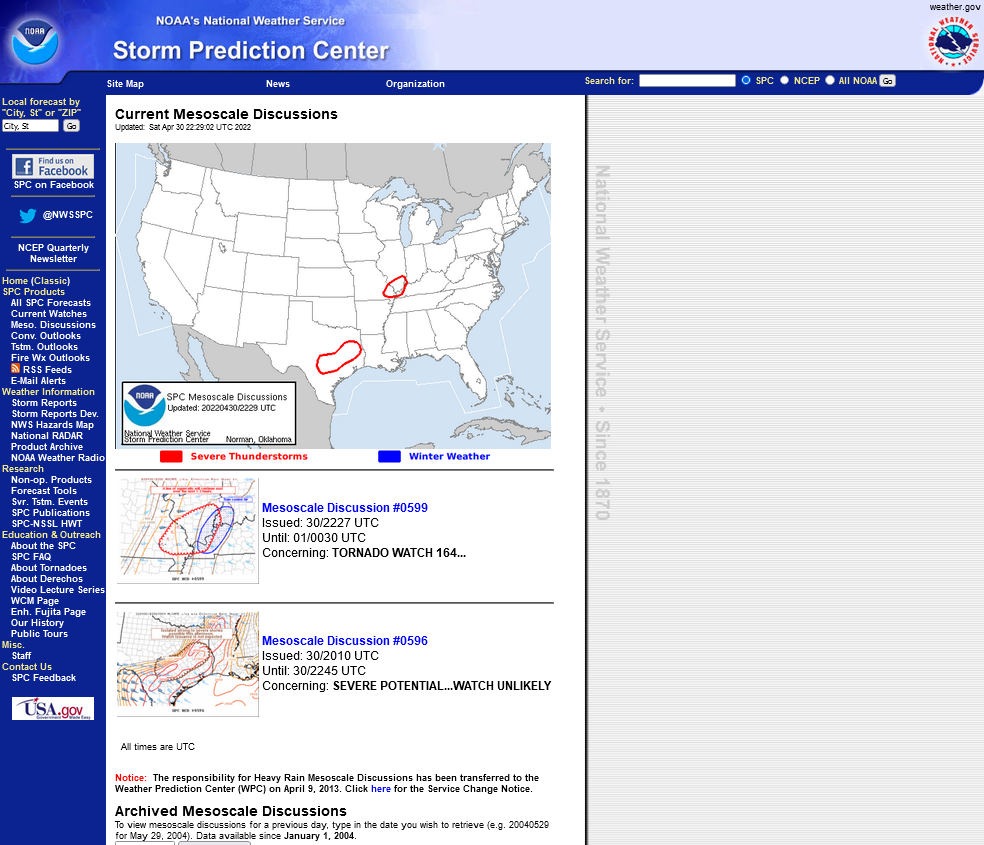
This one was just issued 10 minutes ago:
Their thinking is that the storms will weaken headed east and there will be no need to issue a new watch box east into S.Indiana.
They also added the rain cooled air graphic that's stabilized the air over us.
| Mesoscale Discussion 599 | |
| < Previous MD | |
 | |
Mesoscale Discussion 0599 NWS Storm Prediction Center Norman OK 0527 PM CDT Sat Apr 30 2022 Areas affected...Southeastern Missouri...southern Illinois...far western Kentucky Concerning...Tornado Watch 164... Valid 302227Z - 010030Z The severe weather threat for Tornado Watch 164 continues. SUMMARY...A line of supercells will continue east from southeast Missouri into southern Illinois late this afternoon. The environment appears supportive of all severe hazards for the next 1-3 hours with this activity. The need for a downstream watch appears low, but trends will be monitored. DISCUSSION...A group of four supercells have intensified over the last hour in southeastern Missouri. Regional radar has shown a coincident modest increase in mid-level rotation with these storms. The KPAH VWP shows a modest increase in low-level shear recently. The low-level jet is also expected to increase across southern Illinois this evening. So long as these storms can maintain intensity, large hail, damaging winds, and a tornado or two are possible. Given downstream rain/cloud cover and mid-level ascent shifting northeast with time, storm maintenance with eastward extent remains questionable. Trends will continue to be monitored this evening, but the need for an additional watch appears low currently. ..Wendt.. 04/30/2022 ...Please see www.spc.noaa.gov for graphic product... ATTN...WFO...PAH...ILX...LSX... | |
The threat for any severe storms for the Evansville area would be isolated and minimal the rest of tonight!
Local weather information from the NWS in Paducah that includes the Evansville IN area of responsibility:
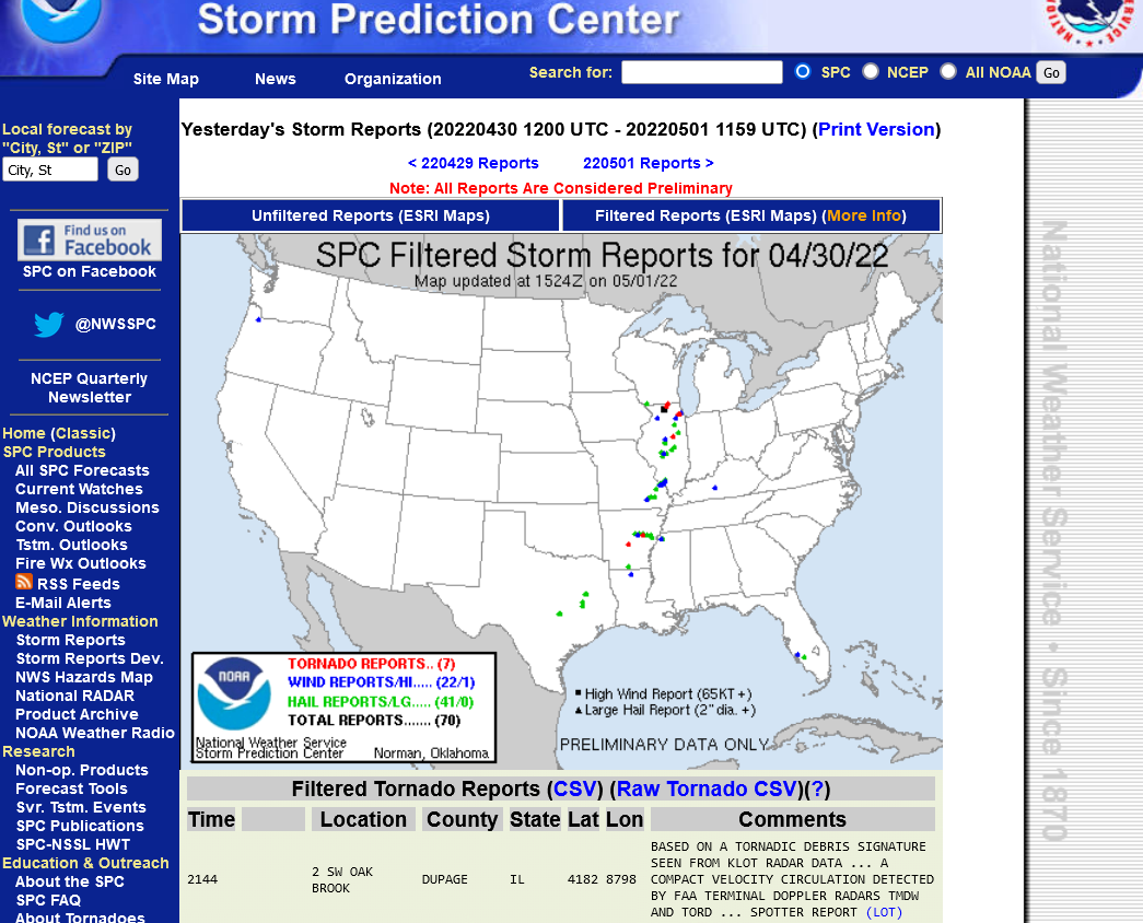
These were the severe weather reports on Saturday from that weather system. As expected, because of the weaker upper level winds(that lift unstable air and give it rotation) the number of reports was MUCH less than the previous outbreak that had a jet stream at double the strength
https://www.spc.noaa.gov/climo/reports/yesterday.html
Previous Storm below

The entire difference was this below
Frozen picture of 500 mb upper level winds THIS TIME:
https://www.spc.noaa.gov/exper/href/

500 mb winds LAST TIME:
https://www.spc.noaa.gov/exper/href/
