A sharp southward plunge of the jet stream will remain in place from eastern Canada through the Midwest and Northeast. This will keep a pipeline of cold air wide open from Canada across the Great Lakes.
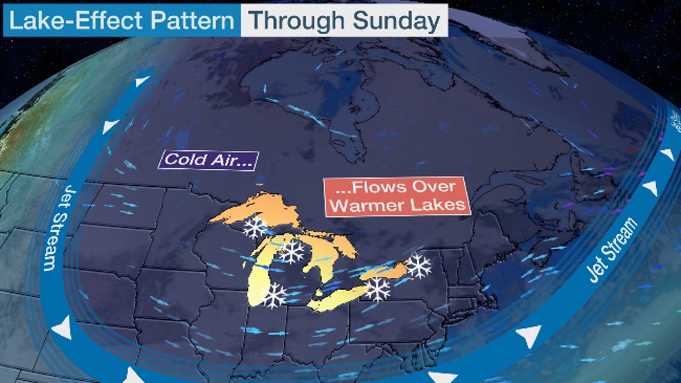
That cold air will flow over the much warmer water of the Great Lakes. This contrast of cold air over warmer lake water will generate bands of lake-effect snow along the downwind shores of the lakes, known as the Great Lakes snowbelts, from western and Upper Michigan to northern Indiana, northeast Ohio, northwest Pennsylvania and in western and upstate New York.
This is a common pattern that usually sets up in late fall and early winter.
(MORE: Five Extreme Winter Weather Patterns To Watch For)
But there are reasons why this will be a more prolific snow event in some places.
First, the Great Lakes are very warm for mid-November, due in large part to one of the warmest starts to November on record. Lake Ontario is the warmest it's been for mid-November in at least 27 years, according to an analysis from NOAA shown below. Lake Erie is at its second warmest for mid-November since the mid-1990s.
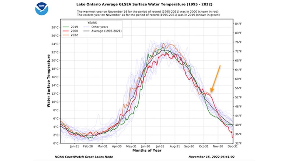
The warmer the water, the more unstable the air is when coupled with the cold air flowing over it. Air can then rise faster into the clouds and generate snowfall more efficiently.
Instability in this case could be so extreme it may manufacture heavy snowbands accompanied with thunder and lightning, at times, producing several inches per hour snowfall rates.
Secondly, winds are expected to line up along the longest axis of both lakes Erie and Ontario.
When this happens, lake-effect snow takes the form of one solid, 100-plus-mile long band of heavy snow as opposed to multiple bands of lighter snow.
Finally, this event will last for several days. That means if the single, long band of heavy snow stalls over a given area, several feet of snow is likely to pile up.

I got an alert on my phone this morning that the Kent State branch in Ashtabula was shut down due to severe weather conditions. It is right in the middle of the snow belt
YOU CAN WATCH, ALL NIGHT ~ IF YA WANNA LOL A STORM CHASER
LIVE ALL NIGHT LAKE EFFECT SNOW EMERGENCY storm chase Buffalo, NY! Historic event
HE'S SAYIN' MAYBE 70+ INCHES. AT 12:39 AM (EST). HE WAS 20 MILES FROM BUFFALO
Hey Jean
Aren't you more NW Ohio than anything else?
And what is your weather status?
John
PS - And Jim M , you're up there too aren't you?
GRRRREAT MEMORY, JOHN!!!
AS I SPEAK, WE'RE AT 28 DEGRESS WITH A REAL FEEL OF 17.... 13 MPH WSW WINDS AND GREEN GRASS ALL AROUND. NO SNOW, EXCEPT FOR A FEW PATCHES
Tracking the snow:
Latest National radar images
https://www.wunderground.com/maps/radar/current

This link below provides some great data. After going to the link, hit "Mesoanalysis" then, the center of any box for the area that you want, then go to observation on the far left, then surface observations to get constantly updated surface observations or hit another of the dozens of choices.
 Found a great new link/site that shows us how much precip fell(from 1 hr to 72 hours) for different periods to share with you. https://www.iweathernet.com/total-rainfall-map-24-hours-to-72-hours Data Update Cycle: The 1-hr mosaic is updated every 5 min (approx). All other mosaics are now updated hourly, including the 48h and 72h maps. The site does not allow me to copy the actual images/data here, as we do with all the other links above..........so just go to the link! |
The wind is especially important with the direction determining where the snow bands line up.

 ++++++++++++++++++
1 mile up below:

Low level lapse rate:

Click a location below for detailed forecast.
Last Map Update: Fri, Nov. 18, 2022 at 10:58:33 am EST
https://www.cnn.com/2022/11/20/weather/buffalo-new-york-great-lakes-snowstorm-sunday/index.html
++++++++++++++++++++++++
As we know, anything and everything that is extreme weather, no matter that it's happened before, no matter that its extreme cold or snow..........WAS CAUSED BY GLOBAL WARMING (even when there hasn't been global warming in 6 years and even when its the opposite of global warming-COLD)
https://www.wsws.org/en/articles/2022/11/19/meuz-n19.html
"As global warming continues, extreme weather events, such as hurricanes, droughts and lake-effect snowstorms(and record cold) will become more frequent, intense and deadly with no serious response from the capitalist ruling elite."

