Time to start a new bean thread!
Old thread here:
https://www.marketforum.com/forum/topic/90664/
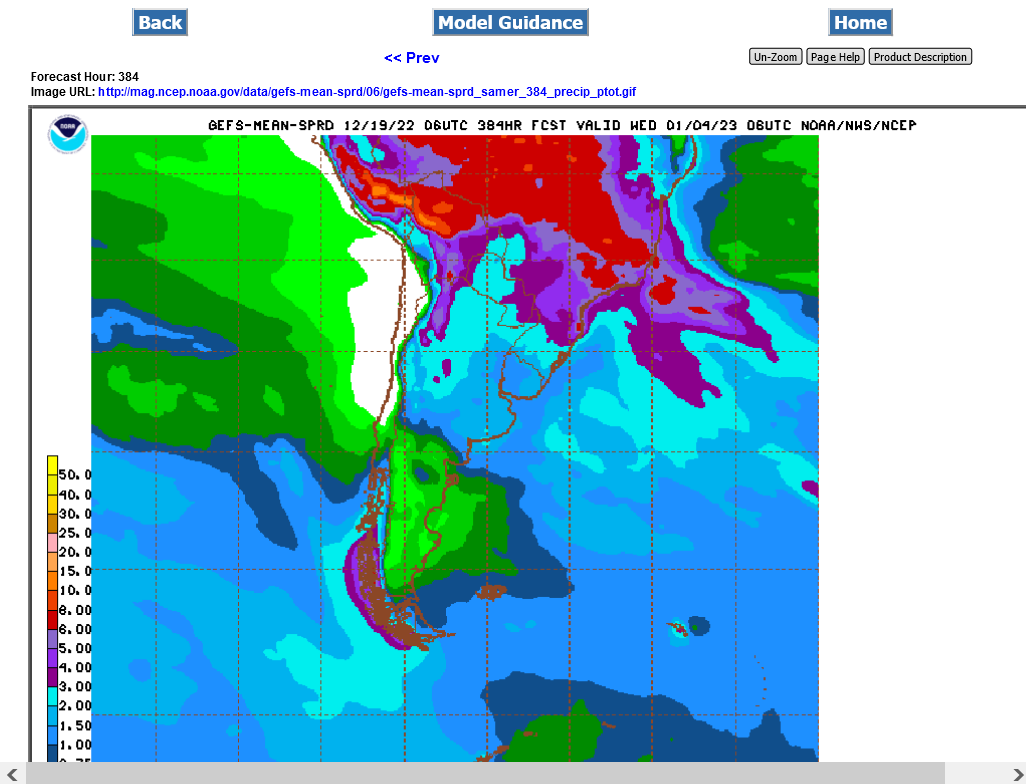
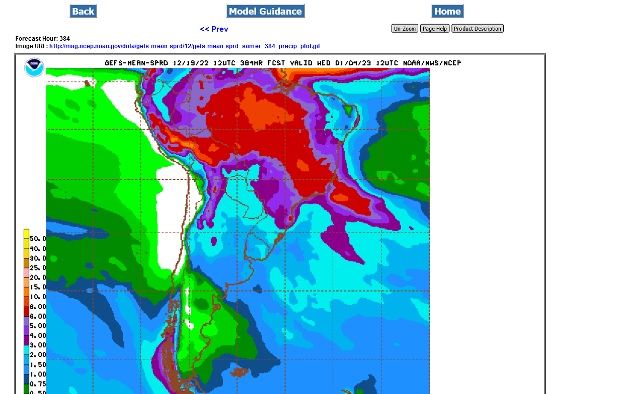
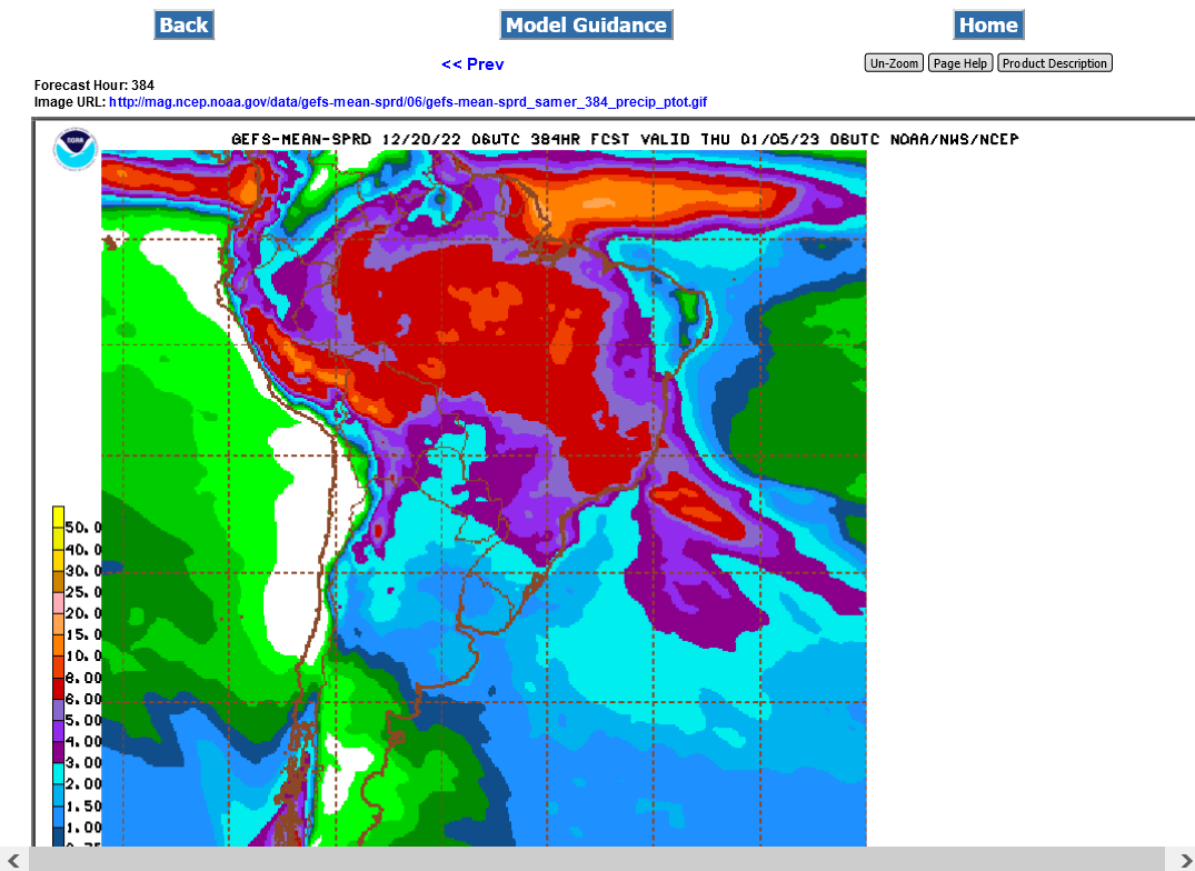
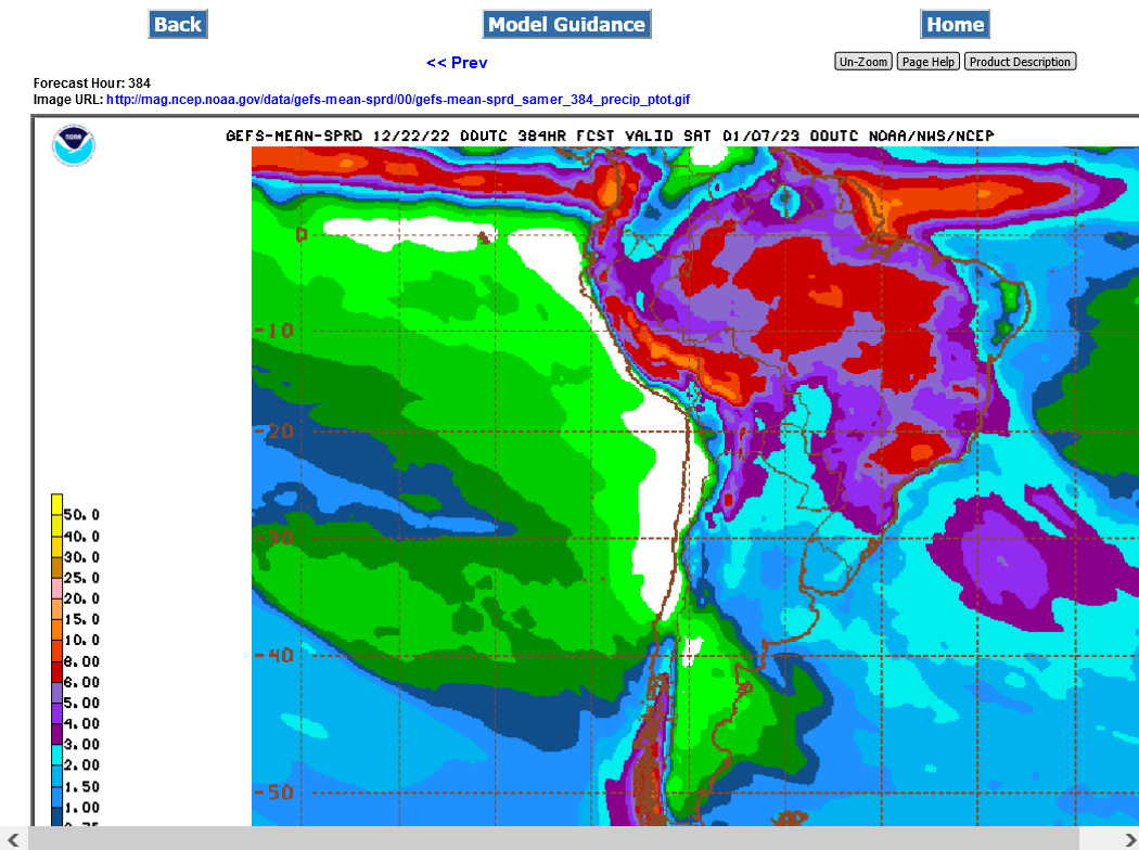
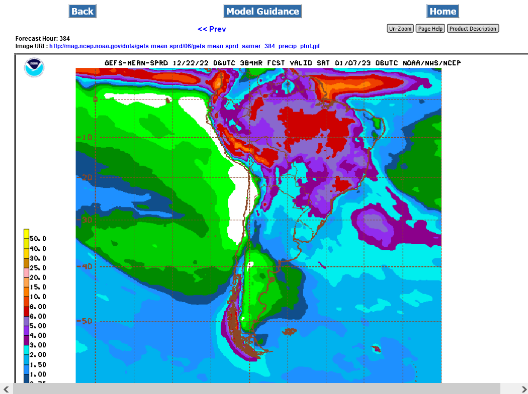
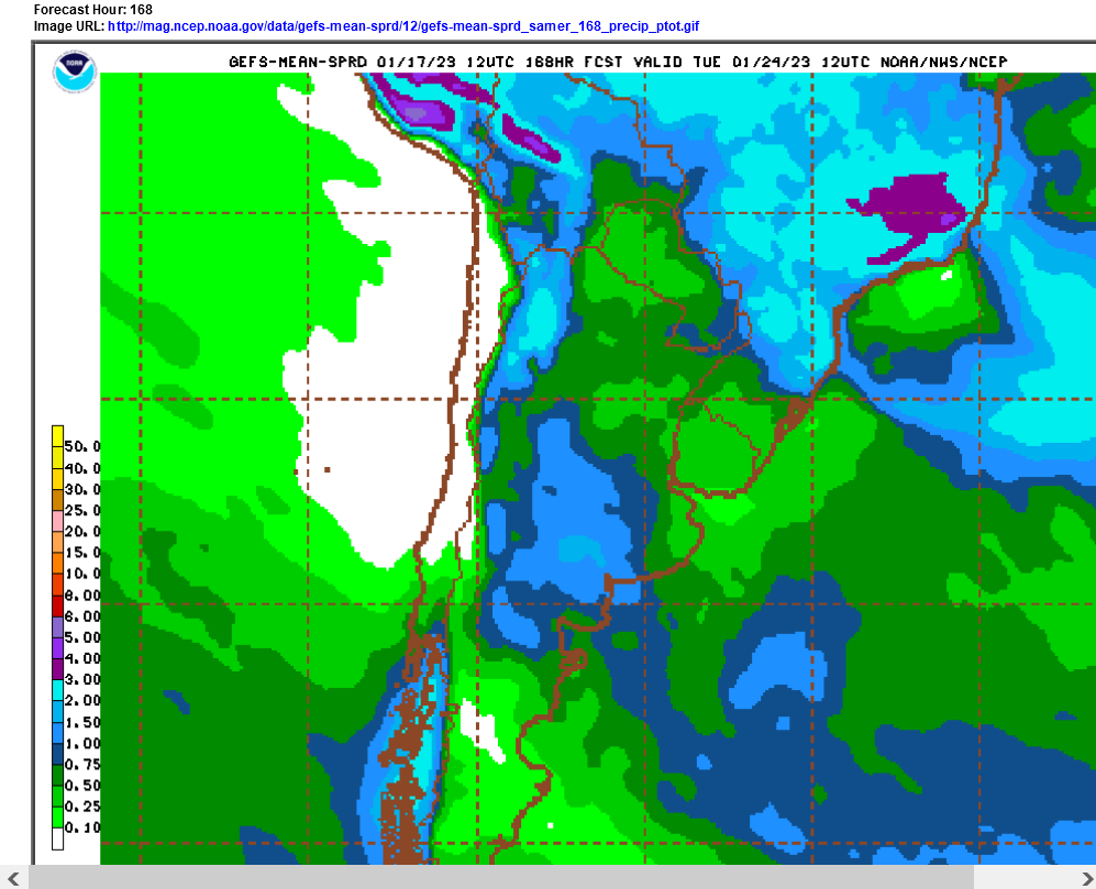
Rain chances have increased this week in Argentina vs last week which is pressuring beans early on in the week.
The 6z GEFS below was slightly drier though.
https://mag.ncep.noaa.gov/Image.php
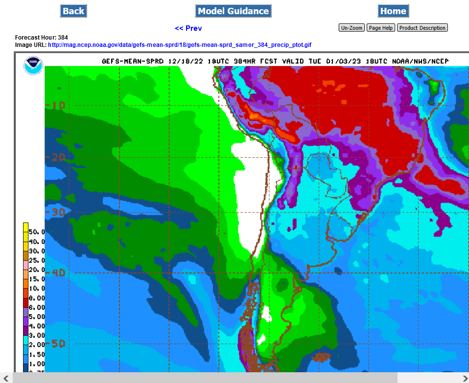
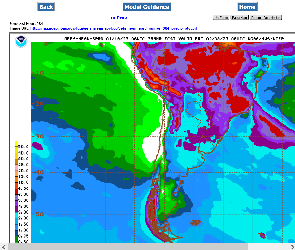
Just out Sunday 18z GFS operational model forecast rains the next 2 weeks:
https://mag.ncep.noaa.gov/Image.php
Last Friday:
https://www.marketforum.com/forum/topic/91473/#91476
By metmike - Dec. 16, 2022, 8:37 p.m.
Thanks Tallpine!
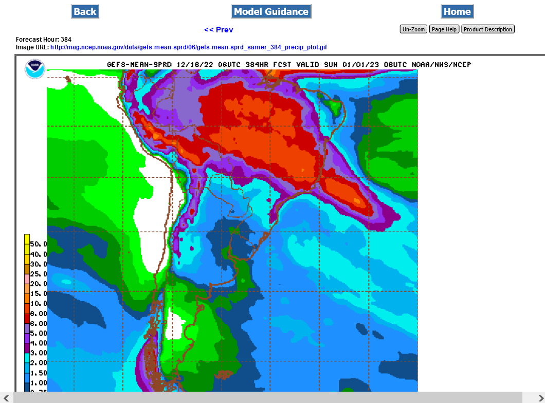
Still below normal rains for most of the Argentina beans and good rains for much of Brazil.........but NOT S.Brazil.
Just out 18z GEFS mean.
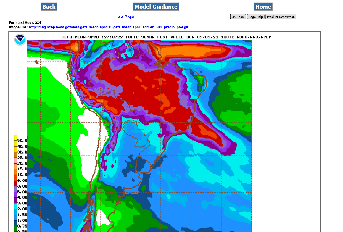
This was the 6z run from 12 hours earlier(on Friday):
https://mag.ncep.noaa.gov/Image.php
https://www.cpc.ncep.noaa.gov/products/Precip_Monitoring/Figures/global/n.90day.figb.gif
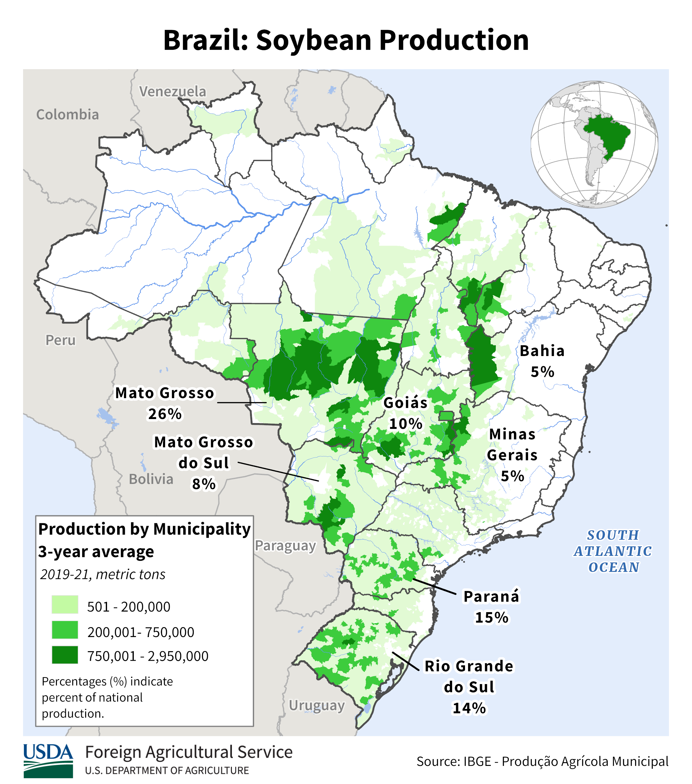
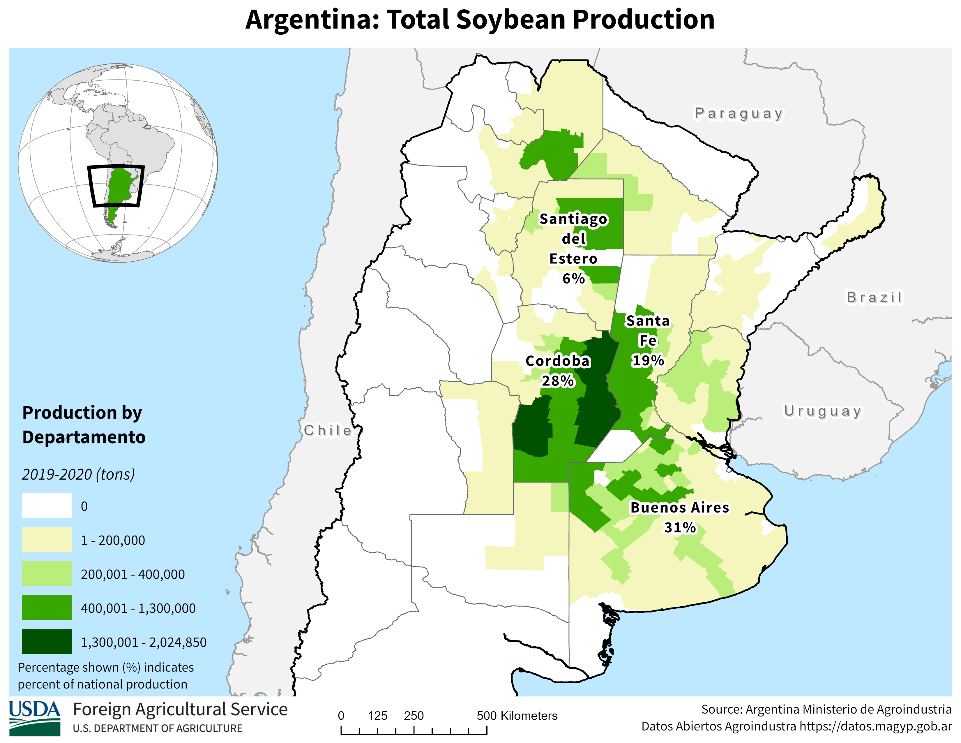
South America soybean production below
https://ipad.fas.usda.gov/rssiws/al/ssa_cropprod.aspx

https://ipad.fas.usda.gov/rssiws/al/crop_production_maps/Brazil/Municipality/Brazil_Soybean.png
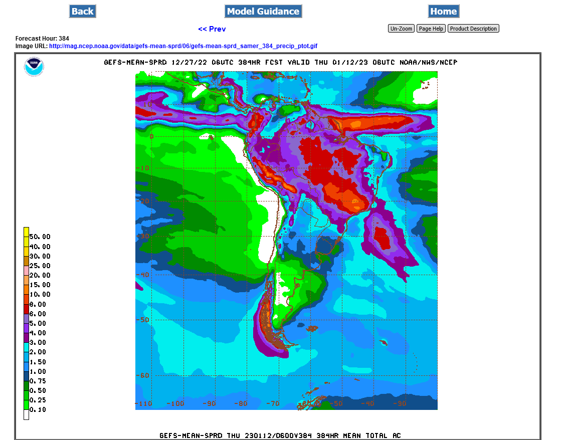
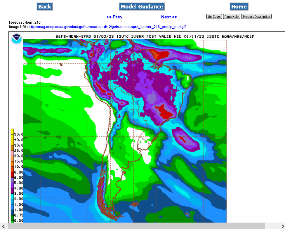
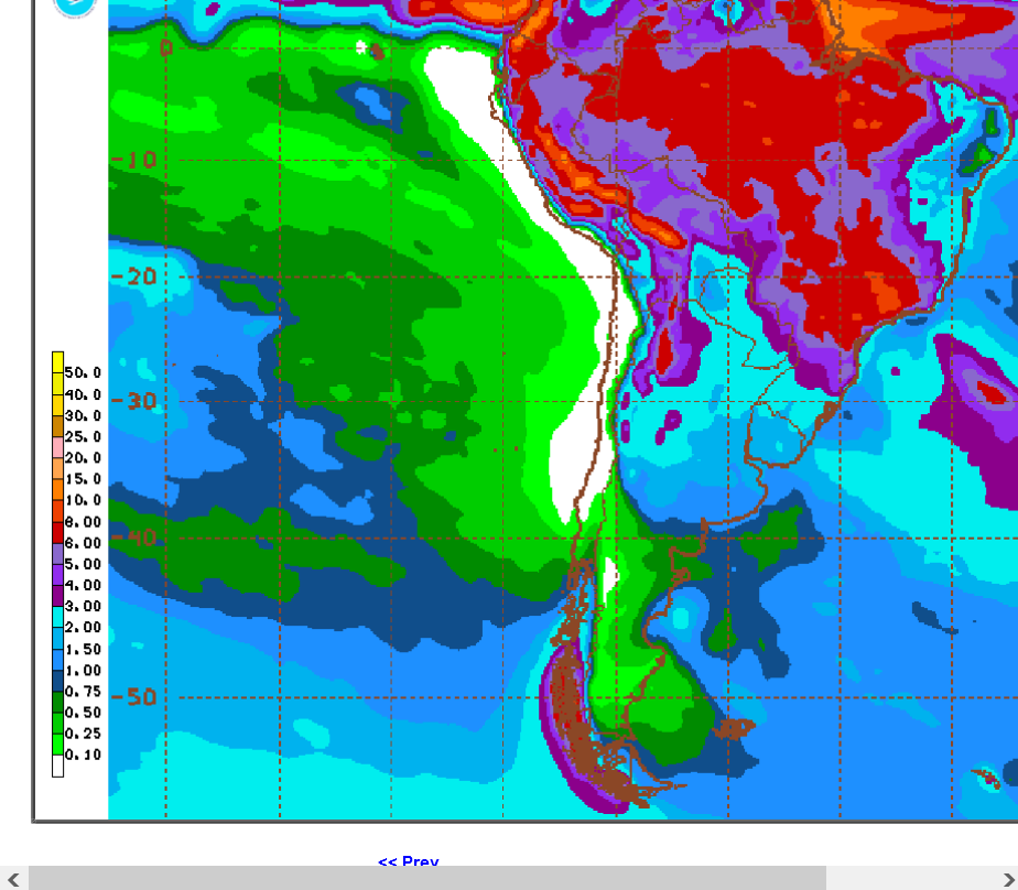
Just out 12z GEFS total 2 week rains for South America.
Amounts continue to be cut back just a smidgen from the previous run in the drought areas of Argentina but still more than last week.
Amounts of rain were cut back a bit more on this last 6z GEFS, 2 week rain forecast.
https://mag.ncep.noaa.gov/Image.php
Last 12z GEFS:

6z GEFS for South America rain. Amounts went up in the southern Argentina growing areas vs the previous runs.

Not much change in rains for Argentina on the 0z GEFS
A bit more rain in the Argentina from the last 6z GEFS:
A tiny bit less rain for Argentina on the last 12z GEFS

2 week Rains continue to be less than early this week in the SOUTHERN growing areas of Argentina that's currently having severe drought from the La Nina (cold water anomalies in the tropical Pacific).
An El Nino (warmer tropical Pacific) and resumption of beneficial warming(that's stalled the past 6 years) will bring the best chance to end their long lived drought and the one in the US!
Soybean thread:
Based on what beans did today and the fact that corn held onto its gains so far today, the market is definitely on edge.
thanks Jim!
I would have posted earlier on this and even tried to buy on the open last night but we were on the road to Detroit and I didn't have my quote program updated with new info on the laptop as well as not following on the Ipad that closely on this little vacation:
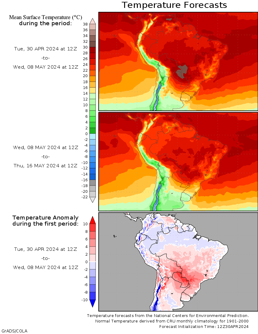
LESS rain in the period that was expecting rain compared to last week but a huge factor is much more HEAT returning in week 2.
Temp anomalies at the end of 2 weeks.
Rains the next 10 days. Southern gorwing areas of drought stricken Argentina very little.

Still looks bullish for beans with regards to lack of good rains in Argentina bean growing areas:

read a lot from a really good met in Uruguay. He has been all over the South American weather this fall. Very accurate so far. He has much more heat and dry coming esp for Argy in January.
Thanks mcfarm, Care to share that with us?
I agree with that because of the La Nina(cold water anomalies in the Pacific) causing this drought.
La Nina's take many months to gradually end and this one will start doing that AFTER the growing season has already ended in Argentina.
Beans breaking out to the upside from the drought continuing in key global producer, Argentina.
2 week rains below from the 6z GEFS.
Brazil weather is outstanding except for the extreme south.
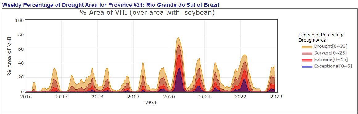
Drought on 30-90 day maps and soybean growing areas of south America:
https://www.marketforum.com/forum/topic/91772/#91776
Heat building back in for Argentina and remaining
https://www.psl.noaa.gov/map/images/ens/t850anom_sh_alltimes.html
http://wxmaps.org/outlooks.php
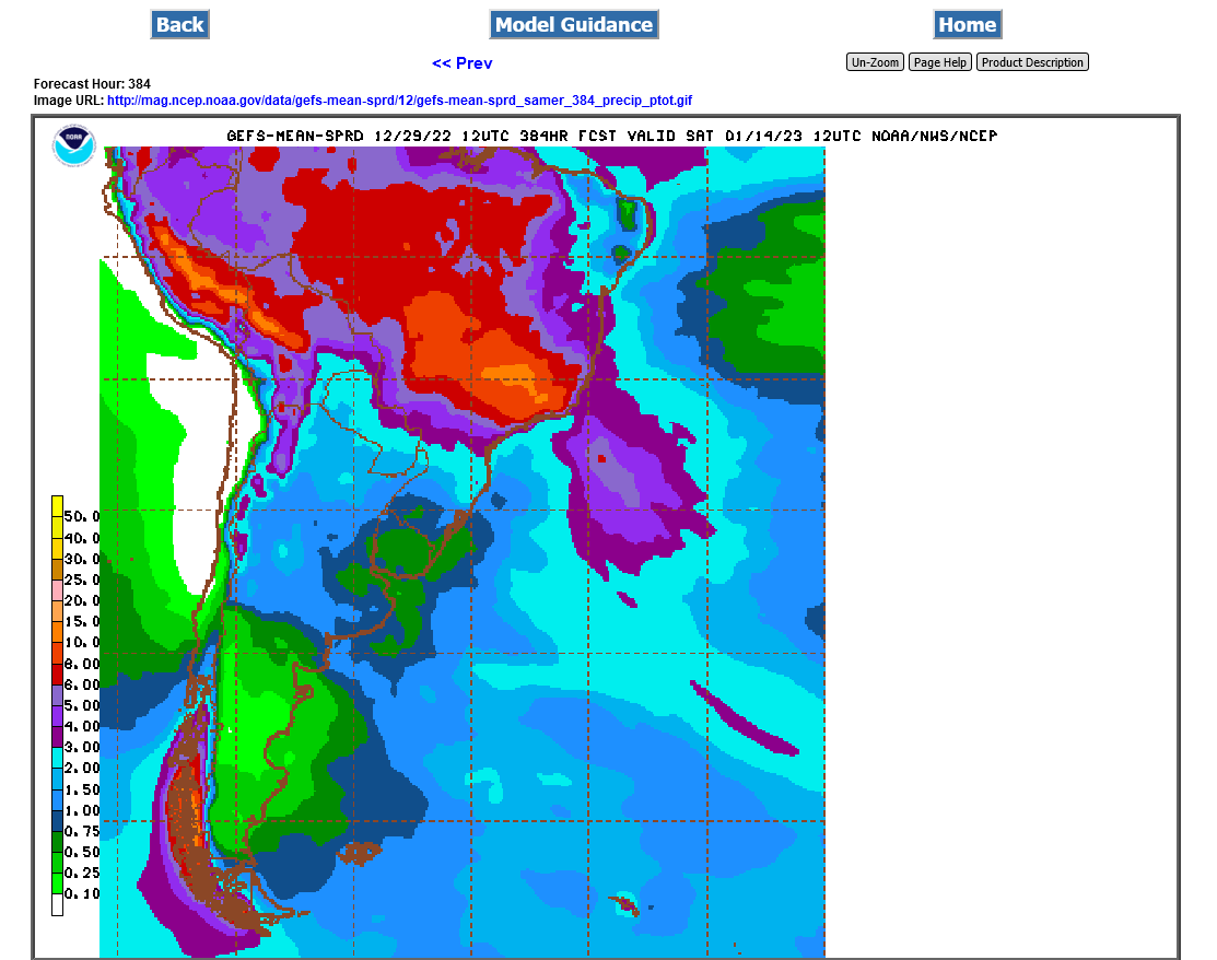
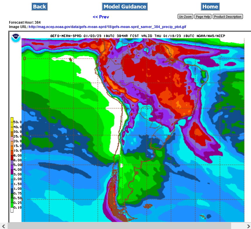
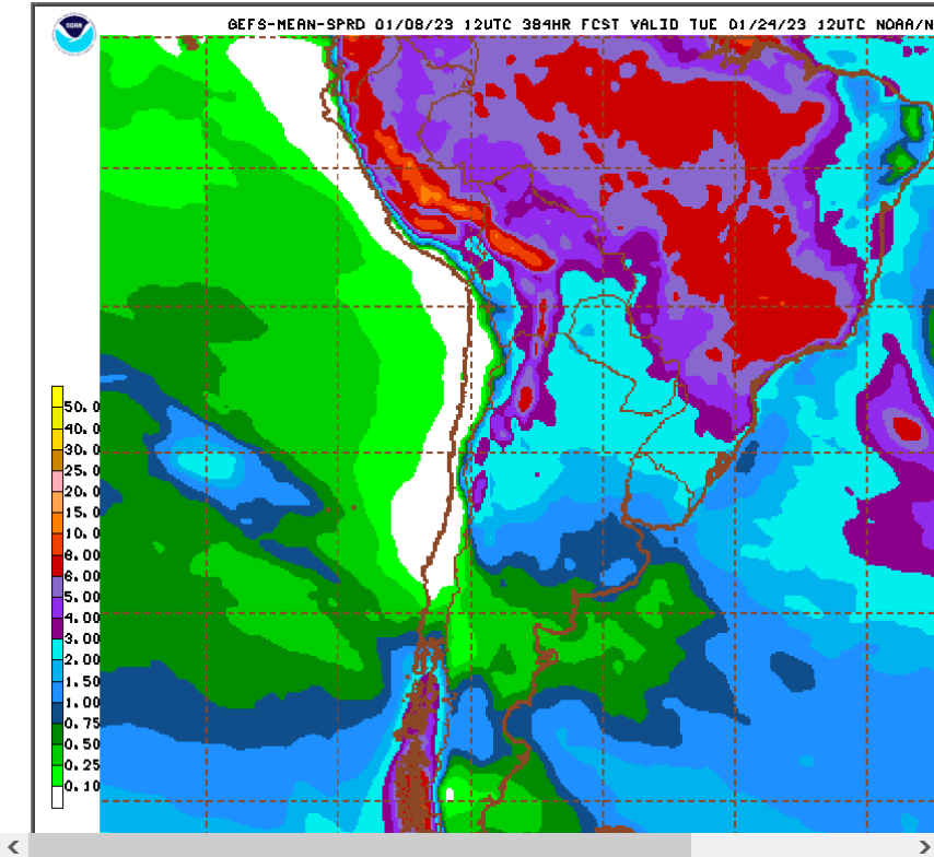
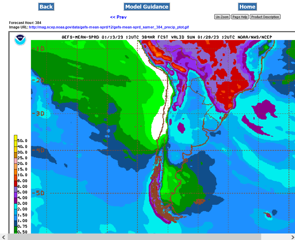
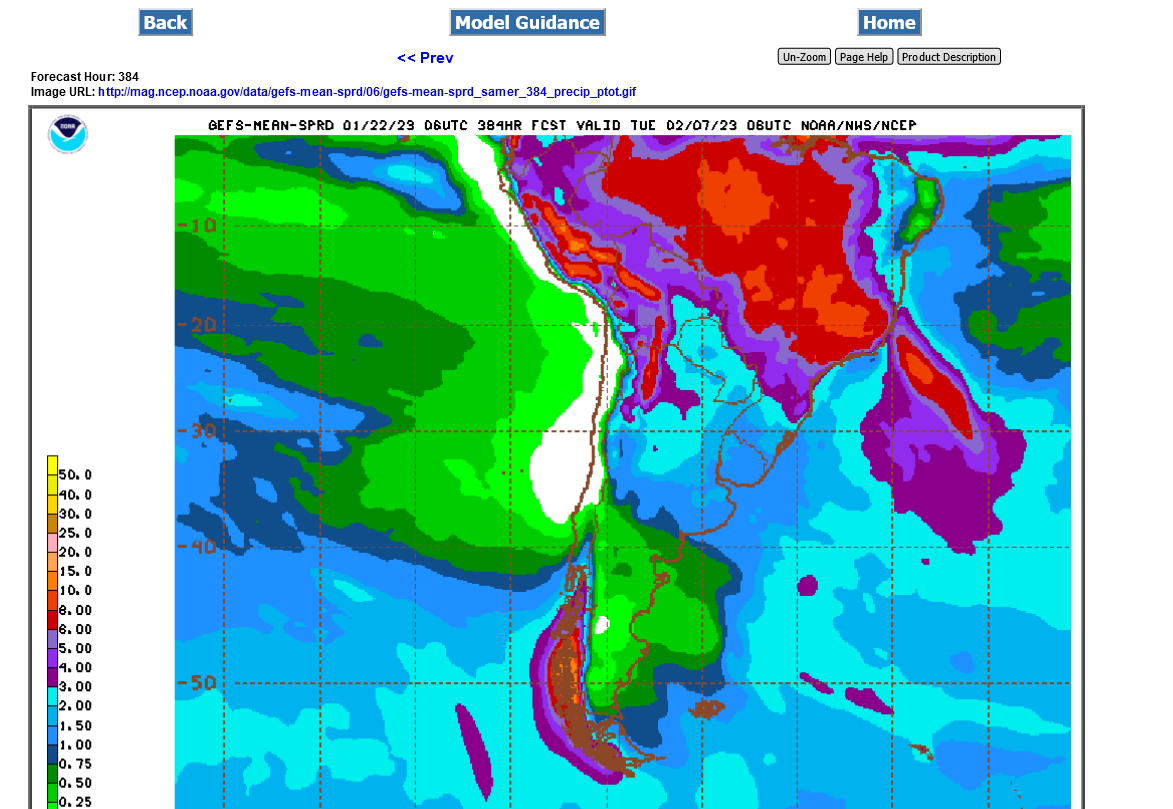
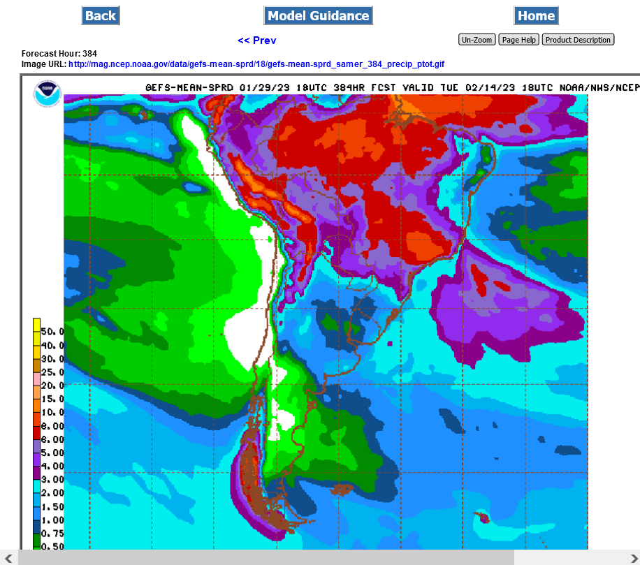
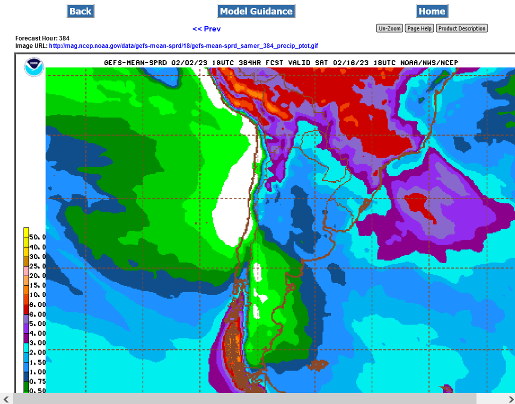
Last 12z GEFS total precip for 384 hours(2+ weeks).
Southeast half of Argentina bean crop has extremely light rains with near record heat (from the current La Nina).
No place in that country has favorable weather.
Brazil has great weather except the far south is affected by the same feature hurting all of Argentina.
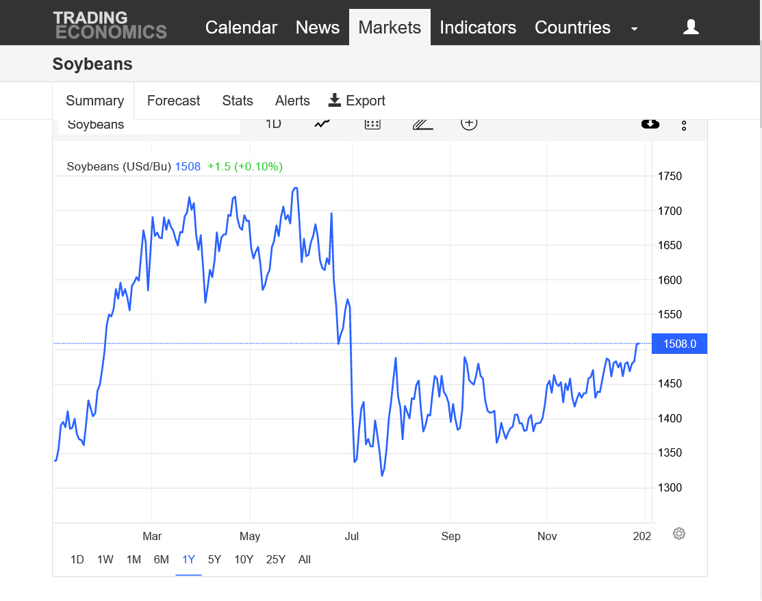
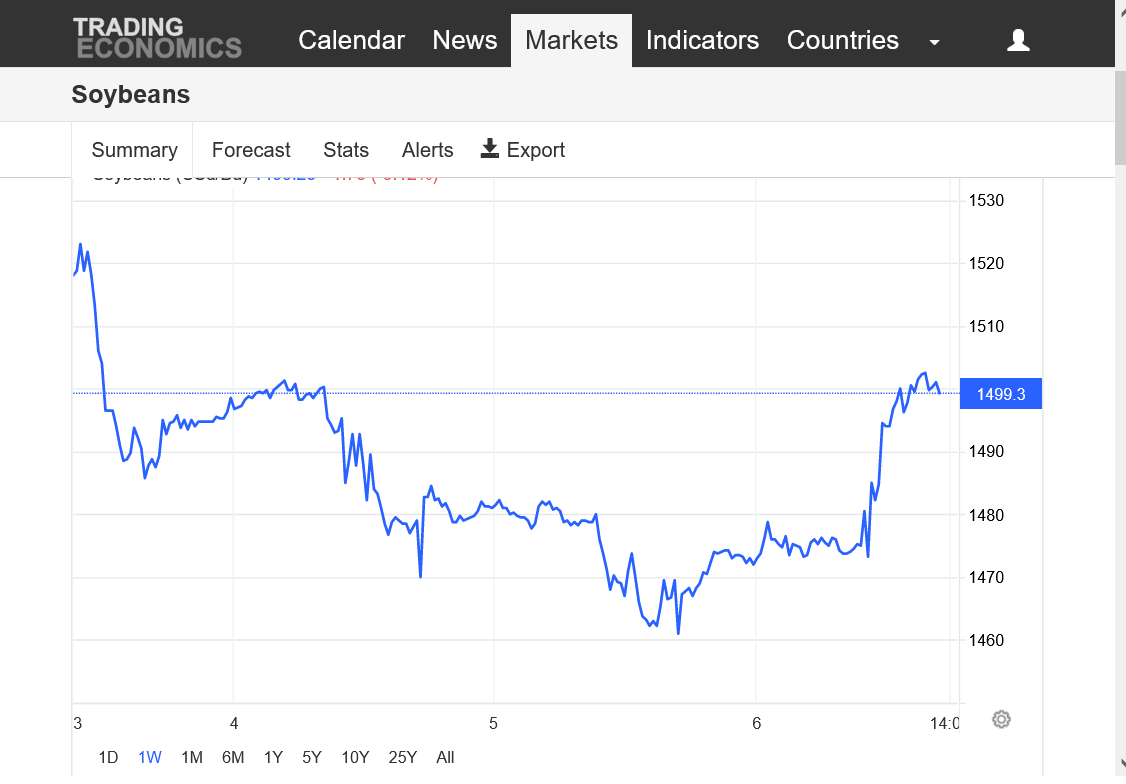
https://tradingeconomics.com/commodity/soybeans
1. 1 year
2. 45 years
Upside break out above resistance:
 !
!
Last 6z GEFS 2 week rains: Hot and below average rain for much of Argentina

Not much change for South America but a bit more rain for Argentina IN WEEK 2!
1st map for the the next 9 days below is extremely bullish-hot/dry.
2nd map is out thru 15 days total rain.
The main change now is that week 2 rain amounts are picking up in drought stricken Argentina!
https://mag.ncep.noaa.gov/Image.php
Rains are still not enough but pick up in week 2 and the La Nina is rapidly dying in the Pacific which will increase chances for drought relief in Argentina later this month.
https://www.marketforum.com/forum/topic/91060/#91893
my SA weather source says next 10 days in Argentina are nothing but high heat. Markets will be spooked until something changes. Continued on about how upset he ways with all the fake el nina talk with lots of cuss words which is rare for him.
Thanks mcfarm,
Soybeans technical picture:
analysis is above each chart.
https://tradingeconomics.com/commodity/soybeans
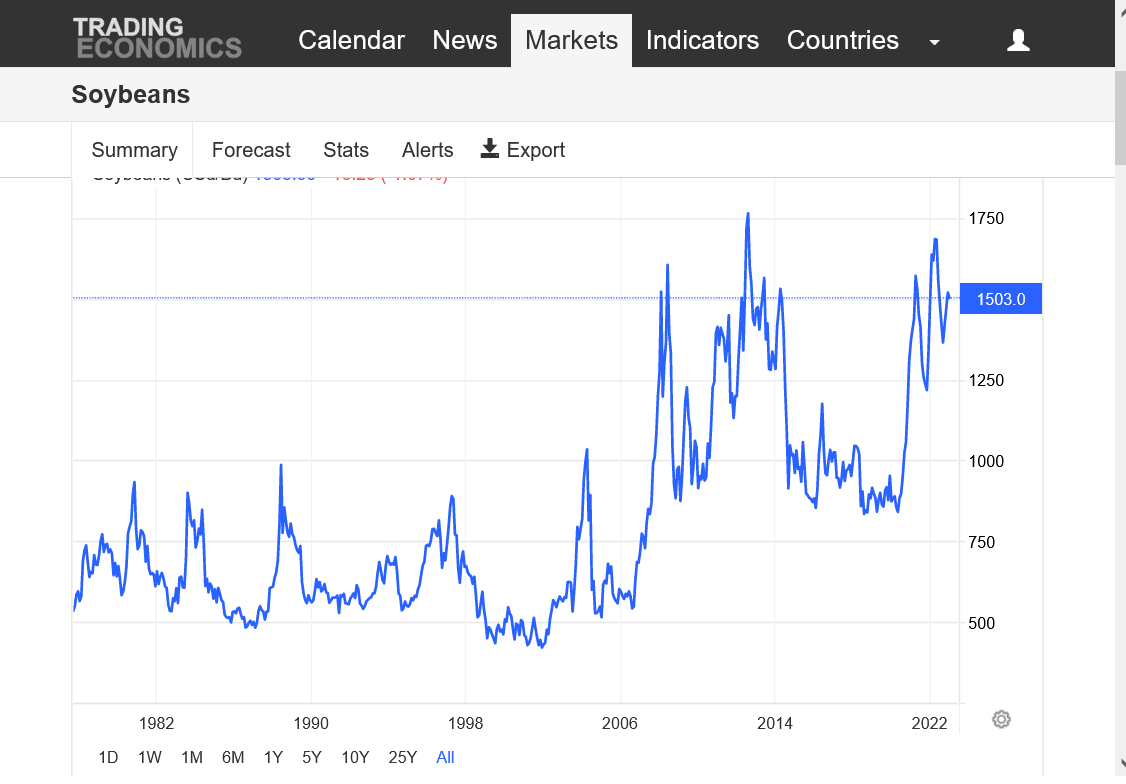
1. 45 years
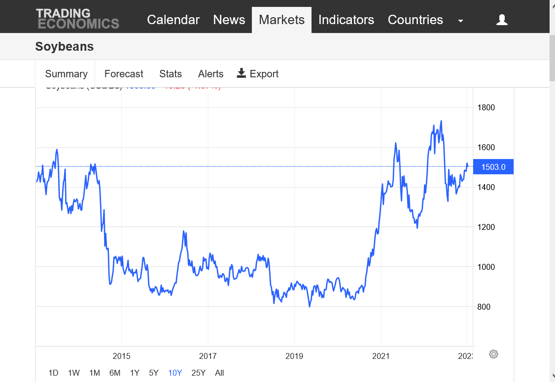
2. 10 years
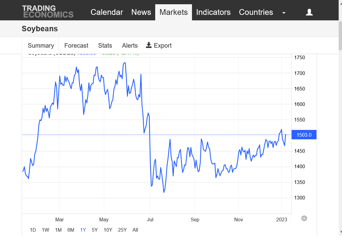
3. 1 year
4. 1 month
5. 1 week
45 years. Triple top? Bull flag/pennant?
10 years= Bull flag, still in an uptrend.
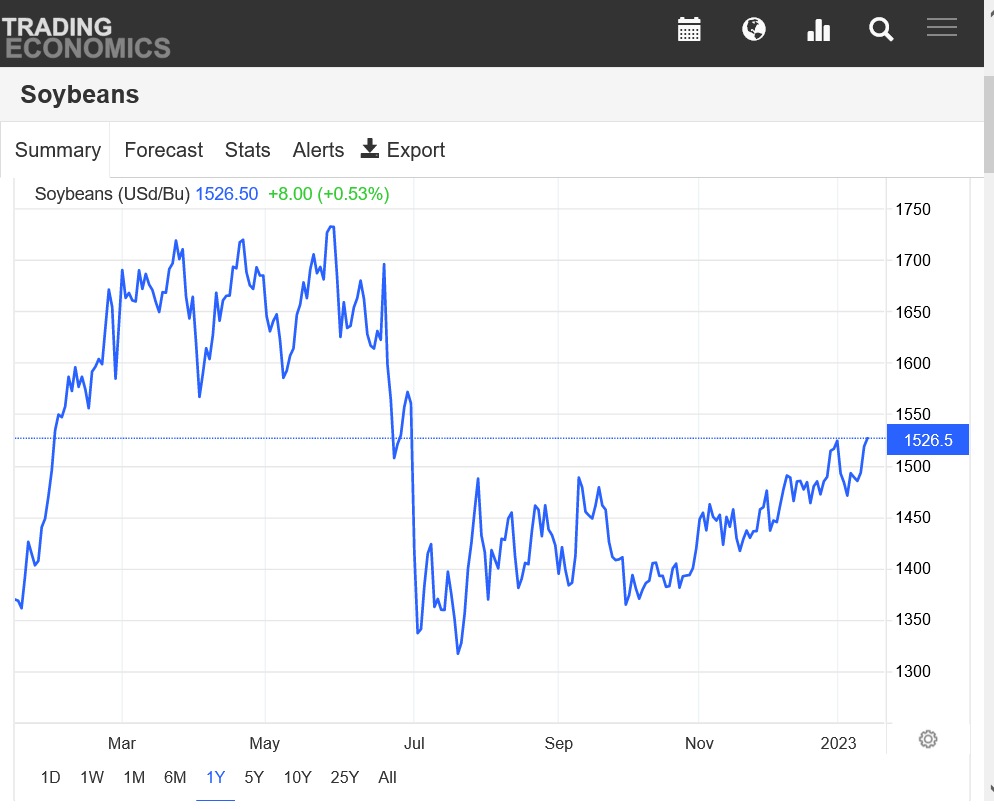
1 year= Triple top last Spring/early Summer. Brief collapse lower June/July, then a steady, solid uptrend with higher lows for 5 months......then an upside break out above 1488-1490 resistance at the end of December(above the Jul-Dec previous highs) that appeared to be failing this week as it dropped below that level.........then, today we reversed back up ABOVE the upside breakout level!
1 month=Sideways trading, then a spike higher at the end of December. A plunge this past week to strong support...........that held and was followed by a huge reversal higher and back above 1490 area resistance.

1 week=dropping lower with 3 waves of selling, each with less momentum. The first one right after the open had huge losses very quickly because the market was closed for the holiday and dialed in weather/price changes from days of no trading in a few hours. Then, 2 waves of buying, the 2nd one today was very impressive and it regained much of the losses. Closing close to 1500 psychological resistance. An inverted head and shoulders bottom signature on the daily chart below would be confirmed with a strong close above the 1500 neckline.
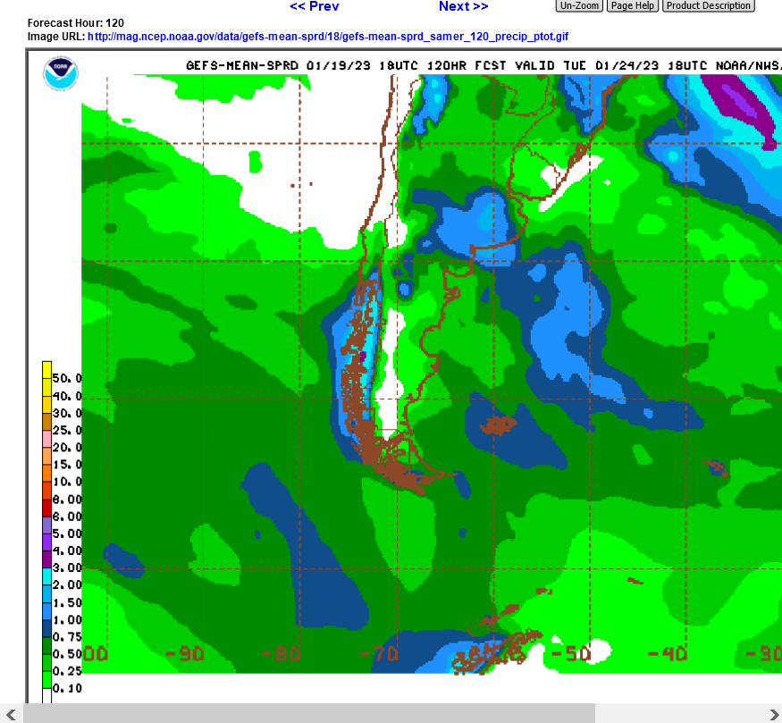
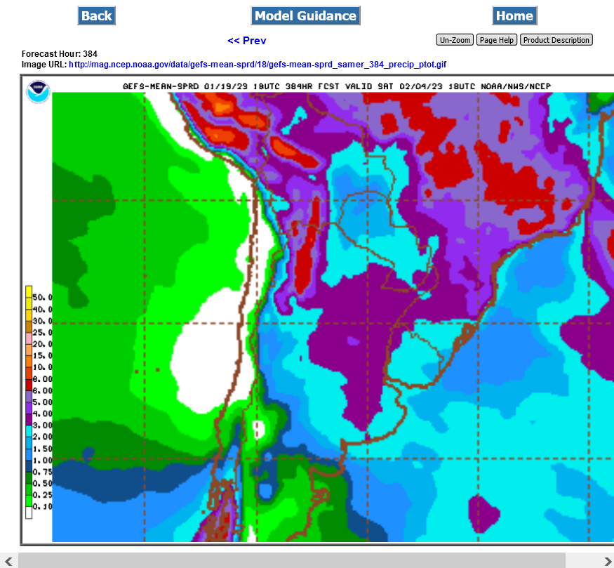
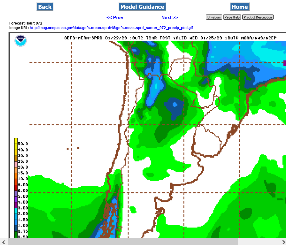
Rains picking up for Argentina AFTER day 4 in the forecast, mainly northern areas. Southern Areas of beans still much too dry.
Latest GEFS 12z total precip
1. 4 day total
2. 16 day total

South America soybean production below
https://ipad.fas.usda.gov/rssiws/al/ssa_cropprod.aspx
https://ipad.fas.usda.gov/rssiws/al/crop_production_maps/Brazil/Municipality/Brazil_Soybean.png
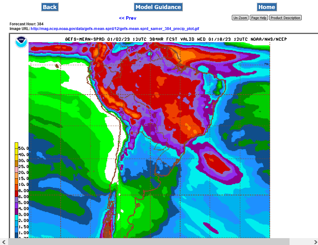
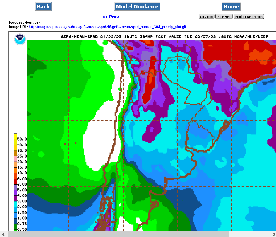
Rains really picking up on this just out 0z GEFS/384 hours, especially N.Argentina(2+ inches):
https://mag.ncep.noaa.gov/Image.php

12z GEFS continues to confirm rains picking up in drought areas of Argentina. Light blue is 2+ inches the next 384 hours.
Rain amounts continue to increase in Argentina's forecast, where drought has dominated for months..........bearish beans.
This was the last 18z GEFS rain forecast out thru 384 hours.
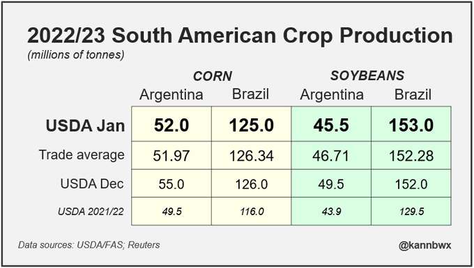
have a contact in Brazil. His new estimate for Mattodosul in now 13.35mmt and the biggest crop in 46 years and for the country of Brazil 153mmt
Thanks mcfarm,
Brazil will have a huge crop but the USDA will make cuts to Argentina's crop on Thursday that are greater than that.
USDA report Jan 12, 2023
Started by metmike - Jan. 9, 2023, 10:14 p.m.
Rain taken out of the forecast for Argentina and big cuts to their crop coming tomorrow-USDA.
Less rain for Argentina on the 12z GEFS run.
Beans continue their upward march, closing just above the Dec 30, 2022 high!
https://tradingeconomics.com/commodity/soybeans
Rains pick up in Argentina, especially late in week 2.
However, the first 4 days of this week will be dry and very hot.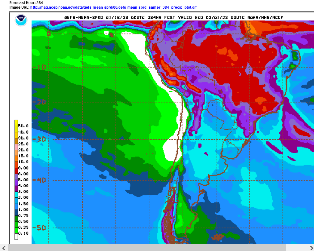
This is really a race between heat, rain and bean growing cycle. I still think the whole SA crop is going to be quite a bit larger than last years.
I still think the whole SA crop is going to be quite a bit larger than last years.
Thaks Jim,
You've been insisting on that for over a month now. It's like saying "water is wet!".
Everybody knew that would be the case BEFORE this growing season because the market already KNEW what last years incredibly poor production was.
In late 2022/early 2023, the market is trading entirely on production THIS year, not on how it compares to last year.
When there are changes in 2022/23 production from weather, they are compared to where that exact same crop was during the previous weeks of the same new crop NOT compared to an entirely different crop a year ago.
That's what's driving price here when it comes to the SUPPLY side. .
Dr Michael Cordinnoir now has 151 and 39 with the next estimates to continue to fall
Thanks mcfarm,
I agree with that. People just don't realize how hot/dry it's been in Argentina this growing season. This last estimate from the USDA is still too high.
added:upcoming rains will help to reverse some of those production losses in argentina but much of it is permanent
2+ inches of rain across most of the ag belt in Argentina, especially in week 2 when the pattern changes to much wetter.
However, the first potentially decent rain event could start this Friday, moving south to north across Argentina on Saturday and Sunday.
the 6z run had a tad less rain withe this 1st event

i think that Jim is going to get paid soon. JMHO
Cutworm,
with beans bumping up to strong resistance and most importantly, the weather pattern changing because of the rapidly dying La Niña and beneficial slight global warming pattern resuming to bring a big increase in rains to Argentina the rest of this month, we could see some major price pressure.
Water is wet! Ha!
Anyway....looking over historical production of SA, it looks like 20/21 was a peak year for SA. Combined, SA produced 184.35 mmt of beans. Using Mcfarms numbers we are currently projected at roughlyt 190 mmt.
Throw in a dying La Nina and more rain and that could climb up to 195mmt very easily.
Beans are grossly over priced.
The last 12z GEFS continued to take out week 1 rains.
Now, almost all the rain is in week 2, so more damage until then.
++++++++++++++++++++++++++++
jim,
mcfarms numbers came from a source that was a mile higher and was agreeing with you over a month ago like everybody else that this years SA crop will be much higher than last years by a huge amount.... but keeps dropping lower and lower from the Argentina drought and not because 2021/22 production changed.
The new crop now will not be AS MUCH bigger than last years crop.......which is what the market is responding too.
+++++++++++++++++
Rains below for week 1 on the last 12z GEFS are pretty skinny(.25 to .5 over key Argentina soybean land.
They started coming out on the run 6 hours ago.
Week 2 rains still look robust.
 .
.
Hey Mike,
Question for you on the weather forecasting models.
They seem to be important tools traders are looking at to help determine the size of the SA crop.
Do the "big" trading firms use these also or do they have their own "proprietary" weather models?
Great question buck.
I don't know everything out there and there are in house models that come out before the main global models but they all originate from the same observations/empirical data/measurements.
This comes from the measurements that each country makes and reports to the global community, which has universal access to it.
Nobody has an edge on anybody else in this key realm because initial observations are what go into every model at the start of each run and those observations are taken at regular intervals that everybody receives simultaneously.
Updated initial data is incredibly important to new model runs and everybody gets it at the same time.
This data is fed into the main global models that come out every 12 or 6 hours. Some models come out much sooner after the data is fed in.
The Canadian model ensembles are always the soonest, the European model ensembles the latest. Most people get this global data at close to the same time but I can often tell that somebody is getting the European model a few minutes before my source by the strong reaction to the market just BEFORE I see the model output.
There are also in house models that I'm not familiar with that probably run in between runs which might give a heads up on the next global model set of solutions.
Funny thing. In the 1990's, before the internet, I had a satellite dish on the roof that was receiving everything the NWS got and sent out instantly and doing my own interpretations.
I turned $2,000 into $600,000, partly on having the data and putting on a position an entire hour before the market reacted during the growing season, in a weather market when the NGM(mid day model) came out different. Those were the days.
Just so you know, I'm not filthy rich. On 10-31-11, Jon Corsine took all my money to make the margin for an over leverage bond trade, then I opened an account at PFG with borrowed money. Then the money that came back from MFG went into the PFG account in 2012 and that guy caused that company to go bankrupt and I lost much of the original money + the borrowed money. 6 figures! And the markets are no longer like the 1990s for me.
Today, my fastest source is online and I often know what the guidance is going to show before it comes out because of the market reaction before I see the data. Somebody else is using the most sophisticated technology available today like I did in the 90's but is beating my source.
That's where they could have some in house models that run the data faster than the NWS computers do. In the old days, you had an entire hour before the data got into the hands of meteorologists who interpreted it and gave the update to the big money trading.
Today, the markets react BEFORE that happens. The big money is eliminating the middle man and has created their own models or sources to get that data and here's another huge deal.............electronic trading.
Previously, you would call your broker and he would place the order with somebody on the floor. You could call first to get the bids/offers...........THEN place the order.
I had a couple of places that filled me while on the phone with huge orders but often, it could take MANY minutes to get your fill.
Now, you can see all the bids/offers and click your mouse and in less than a second.........you're filled.
People with the updated weather info are clicking their mouses the instant that it comes out and a few seconds will frequently mean a huge difference(especially in natural gas)
Did you see this story today? China’s population dropped almost 1 mil last year.
https://www.npr.org/2023/01/17/1149453055/china-records-1st-population-fall-in-decades-as-births-drop
we have had quite a run since harvest. There will be some of my beans sold on this rally
Thanks so much for the explanation. I guess what prompted my question was wondering if the big guys were getting a head start on the info we were seeing. Sounds like they are!
Not that it really effects my trading...I am mostly a trend following type trader...but it seems that a lot of market moves based on weather, USDA reports etc are "forshadowed" by moves in the market shortly before the data is release.
YW buck,
I really don't have all the information about this but its such a great question, that I'd like to know more specifics.
previous Re: INO Evening Market Comments
By metmike - Jan. 18, 2023, 3:33 a.m.
Thanks tallpine!
Rains really pick up but not until week 2 in Argentina.
beans are breaking out to the upside with the highest price since they were crashing lower at the end of June from 17 to 13.50 in 2 weeks.
at some point those rains getting closer, if they don’t .dry up will crash beans. Rains for later this weeks have faded in the guidance the last 2 runs.
+++++++++++++++++++
The big increase in rains in week 2 are finally crushing beans today.
This is one market I would have had my clock cleaned yesterday based on thinking that rain would have kept the pressure on.........they were down, then reversed and went higher, to easily make new highs for the move last night.............BEFORE finally taking a dump today.
The amount of rain has increased from 2+ to 3+ inches of rain, almost all week 2. That's the most rain since...........man, I don't know. Many months.
This was the last 6z GEFS. The 12z run is finishing up now.
Thanks for that great contribution Jim! Fascinating.
Last update here. 3+ inches of rain coming.........AFTER day 5 https://www.marketforum.com/forum/topic/92306/#92307
Weather suggests 'perfect' timing for beans? Equivalent late July for USA crop?
IF, IF the next week has any precip, the bullish scenario is gone?
(BIAS--short meal)
tjc,
If this forecast does not change, I will be surprised if beans are not lower next week.
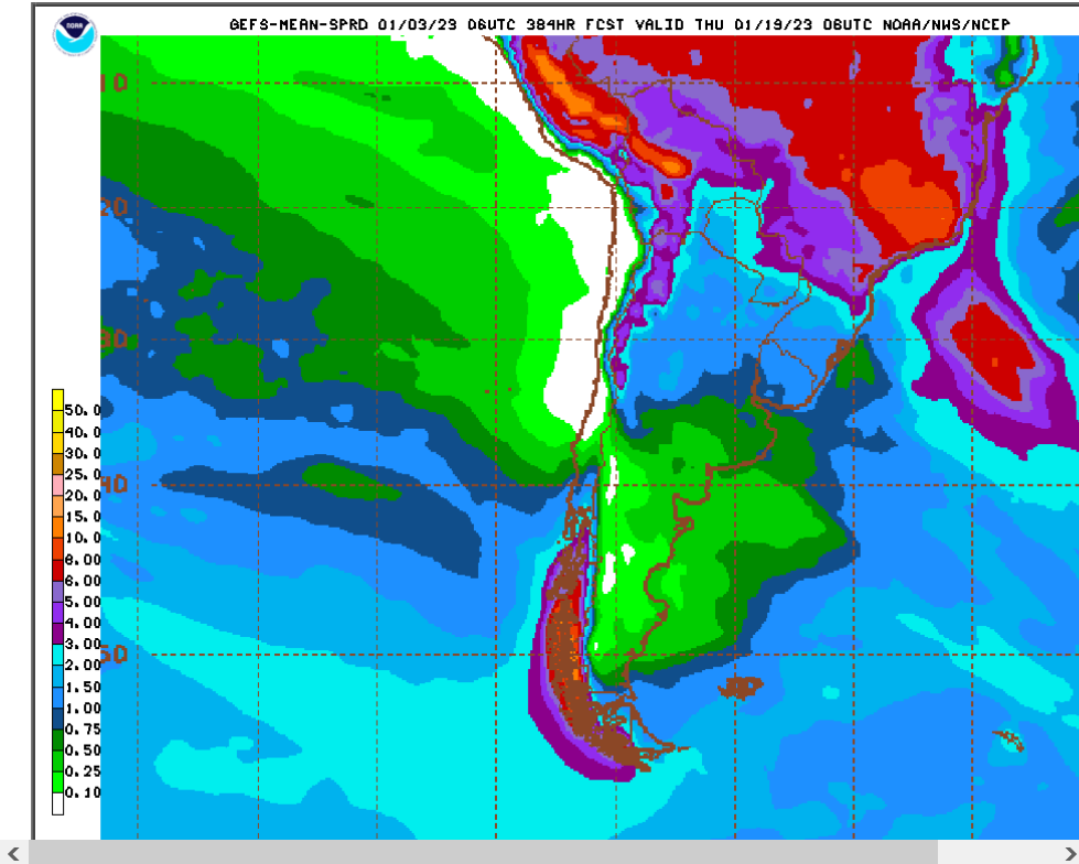
1. Rains the next 5 days...mostly southern areas of Argentina
2. Rains the next 15 days every place gets 3+ inches with some getting 4 inches. Most after 5 days.
Beans should be lower next week:
Another trade I was 'early'. But the wednesday reversal now seems to be fullfilled by the rain, a fundamental
tjc,
The Wednesday reversal was CAUSED BY the forecast for widespread 3+ inches, up to 4 of rain.
When moves happen first, then traders find out about the weather 2nd........it means traders had the weather information BEFORE you that caused the move in a weather market.
The objective of a skilled weather trader is to be 1 step ahead of traders causing the move.
However, in a weather market, when the forecast changes back and forth, the market reaction jerks up and down. It's only good for one trade in one direction when we have A MAJOR PATTERN CHANGE that changes the weather from really bad to good or really good to bad.
It was clearly looking like a major pattern change last week for soybeans grown in Argentina from really, really bad to good...........but rain has been getting taken out of the forecast since Friday. Some of this is because of rains that fell this weekend. We'll have to see how much that was too.
2 week rains from the last 6z GEFS. The highest production areas in Argentina are right on the edge of the 2+ inch rains and slight changes will make a huge difference.
tjc, the source with boots on the ground give the opinion that those crops hurt are hurt beyond repair. Argy beans crop esp. If this thing does sell off hard there is a gap back somewhere around 1270
mcfarm makes a great point and I think that's why beans surprised me early in the week, when rains were increasing, they were dropping, then suddenly they made new highs.....THEN plunged to the lows at the end of the week.
The hot/dry weather in Argentina soybean areas during the first half of this growing season is worse than anything that I remember while tracking their weather the past 2+ decades.
It's probably been worse in a few years in the past........but not while this many beans are growing in Argentina.
McFarm/MetMike
Certainly ENJOY the constant feedback and contributions.
"My" weekend chart review and comments on my charts suggest I take advantage of an "ugly" Monday to capture a profit. Timing suggests cycle low timeframe Mon/Tues. Monday for beans (hopefully a day with no major bounces and a close on/near the low). Tuesday for corn.
Thanks tjc,
I had to zoom in and look real close to see how rains are shaping up for Argentina.
The northern areas will get a bit of rain the next 3 days but the rest of the areas will get it after that. 2+ inches with the western areas getting 3+ inches.
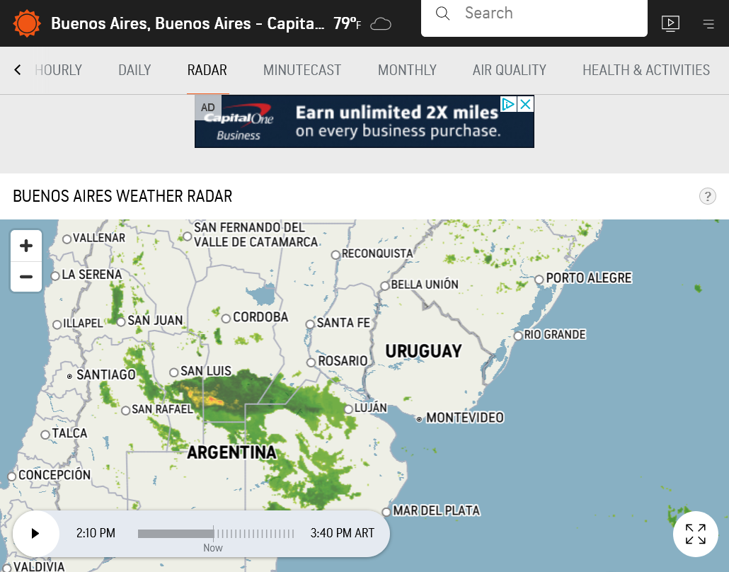
Here's a current radar source for Argentina that seems to be pretty good. You can expand it to see a much larger area by hitting the - on the screen and run a 3 hour loop too.
https://www.accuweather.com/en/ar/buenos-aires/7894/weather-radar/7894
"UPON further review---meal seems much more vulnerable. May hold short beyond Monday
mcfarm,
I never knew that you were bilingual (-:
Care to provide us with a translation?
Rains in Argentina drought areas are being reduced in the forecast:
Just out 18z GEFS 384 hour rains.
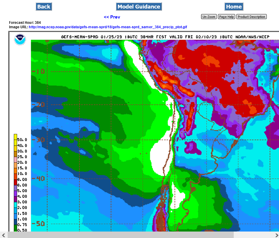
Much of the rain has fallen for Argentina.
Now we go back to the drier than average forecast for the next 2 weeks....bullish beans.
https://www.accuweather.com/en/ar/buenos-aires/7894/weather-radar/7894

Last week/month of rains. Not bad from many spots in Argentina bean-land.
https://www.cpc.ncep.noaa.gov/products/Precip_Monitoring/Figures/global/n.7day.figb.gif
https://www.cpc.ncep.noaa.gov/products/Precip_Monitoring/Figures/global/p.30day.figb.gif
2 week rain forecast from the just out 18z GEFS.
From Friday:
In a break from the overall hot and dry La Nina pattern, Argentina picked up some very good rainfall between Jan. 15-26. Overall, rainfall totals in the heart of the main growing regions were widespread in the 75- to 150-millimeter (roughly 3- to 6-inch) range during that time frame. And there have been isolated cases up and over 200 mm (roughly 8 inches) where rains were even more persistent.
The rains led to significant improvements in crop conditions and soil moisture in Argentina, according to the Buenos Aires Exchange. In its report released on Jan. 27, good-to-excellent ratings for both corn and soybeans rose greatly, while poor ratings fell sharply during the last week. For corn, good-to-excellent ratings rose 10 percentage points to 32%, while poor ratings fell 9 percentage points down to 28%. For soybeans, good-to-excellent ratings rose 8 percentage points to 38% while poor ratings fell a similar 8 percentage points to 19%. For soil moisture, the amount of crop in drought also fell during the last week -- from 44% to 28% in corn areas and from 52% to 36% for soybean areas. There is still some room for improvement, and the drought is not over for everyone, but producers are definitely breathing a sigh of relief about the weather conditions from the last two weeks.
Beans getting clobbered, filling the gap higher Sunday Night.
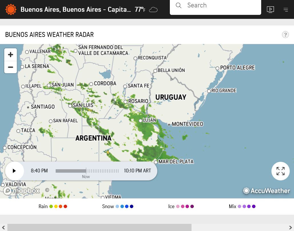
Big rain event in key Argentina growing region.
https://www.accuweather.com/en/ar/buenos-aires/7894/weather-radar/7894
Big rains from earlier are diminishing. The next rain event will be almost 10 days from now.
It's getting late in the season for weather to have a huge impact in most areas.
I read the USDA dropped the size of Argentina's crop to 31mmt.
Thanks much, Jim!
Weather in Argentina is just about played out for this growing season:
