Please scroll down for the latest updates!
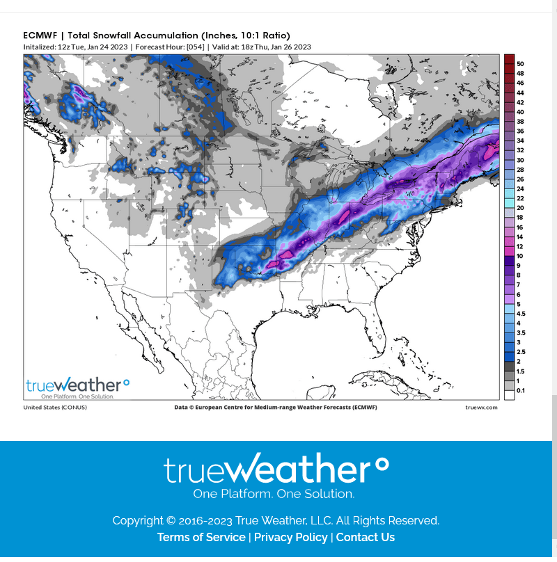
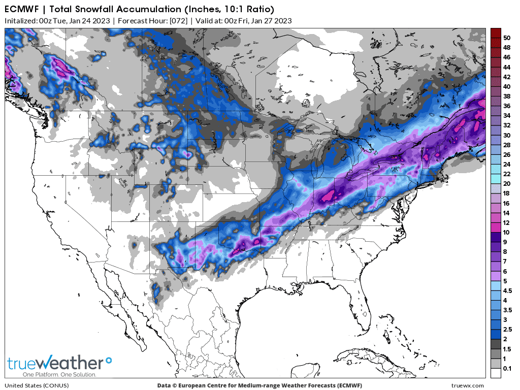
Total snow accumulations the next 2 weeks from the just out 12z European model.
Thank you, MetMike.
NOT what my wife wants to hear.
I will forbid grandma driving from Illinois to Annapolis to visit grandchildren, Snowy roads on I80 way too treacherous in Pennsylvania. Midway to BWI will be just fine!
YW tjc!
CLICK ON THE MAPS BELOW TO SEE FULL SCREEN.
Snowfall Probability Forecasts
The following charts depict the probability of snowfall reaching or exceeding the specified amount.
Current issuance cycle: 12Z (updated 1423Z, January 23, 2023)
All viewing options are available through the links below.
|
| Specific accumulation thresholds for Days 1-3: | All accumulation thresholds for: | |
| ≥ 1 inch | ≥ 8 inches | Day 1 |
| ≥ 2 inches | ≥ 12 inches | Day 2 |
| ≥ 4 inches | ≥ 18 inches | Day 3 |
| ≥ 6 inches | ||
Current issuance cycle: 12Z (updated 0840Z, January 23, 2023)
| Day 1 | Day 2 | Day 3 |
≥ 4 inches | ≥ 4 inches | ≥ 4 inches |
≥ 8 inches | ≥ 8 inches | ≥ 8 inches |
≥ 12 inches | ≥ 12 inches | ≥ 12 inches |
24-, 48-, and 72-Hour Snowfall Percentile Accumulation Forecasts for Days 1-3
Day 4-7 Outlook
Current issuance cycle: 12Z (updated 0505Z, January 23, 2023)
|
Tracking the Winter Storm Tuesday/Wednesday!
Current Hazards at the link below.
Go to the link below, hit hazards box in the top right hand corner(it will also define all the color codes), if its not already in the hazards mode when you load the link.
Then you can hit any spot on the map, including where you live and it will go to that NWS with all the comprehensive local weather information for that/your county.

Latest National radar images
https://www.wunderground.com/maps/radar/current

This link below provides some great data. After going to the link, hit "Mesoanalysis" then, the center of any box for the area that you want, then go to observation on the far left, then surface observations to get constantly updated surface observations or hit another of the dozens of choices.
 |
LOWER MIDWEST
https://www.spc.noaa.gov/exper/mesoanalysis/new/viewsector.php?sector=20

https://www.spc.noaa.gov/exper/mesoanalysis/new/viewsector.php?sector=20#

https://www.spc.noaa.gov/exper/mesoanalysis/new/viewsector.php?sector=20# 
There is disagreement on the area of the heavy snow because of the amount of just above freezing air near the surface that gets entrained with an easterly wind to create a surface temperature in the mid 30s or a tad higher. That's the horizontal temperature profile.......barely warm enough for rain but if its 2-3 degrees colder and its mostly snow.
The vertical temperature profile too is a bit unique.
It will be just cold enough for mostly snow as far south as the Ohio River in sw Indiana but the models have just enough warm air in the last several thousand feet down from that eastern wind to melt it and result in cold rain that far south.
So Evansville is mostly rain ACCORDING TO MOST MODELS.
However, some models have it slightly colder near the surface and see a mostly snow event with 5+ inches getting almost as far south as Evansville.
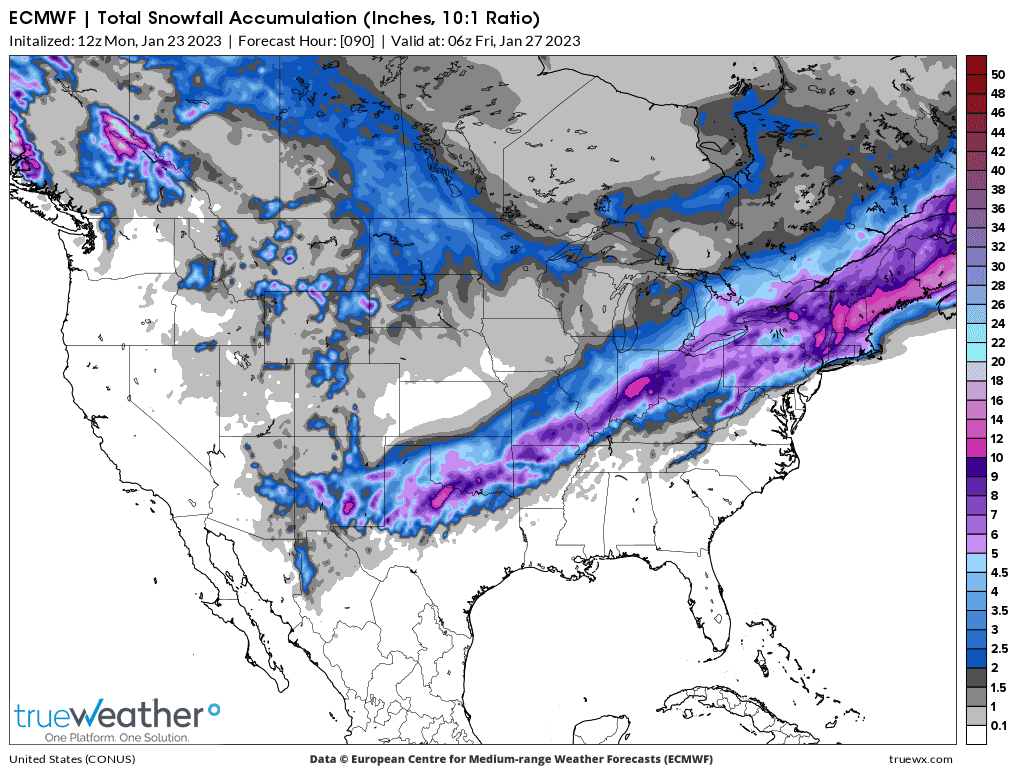
This is one of those models bullish for heavy snow down to Evansville, the last 12z operational European model.
This is the total snow forecast from this Winter Storm, thru Thu.
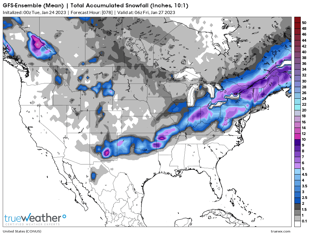
Most models look like this below: The just out 0z GEFS run.
Click a location below for detailed forecast.
The just out 0z operational European model continues to insist on 5+ inches of snow as far south as northern sections of Evansville/N.Vanderburgh county.
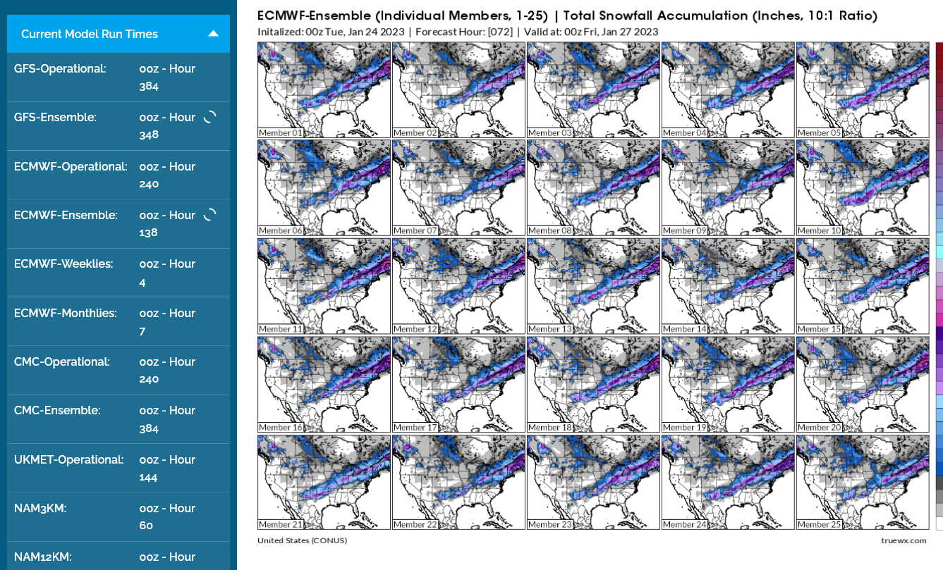
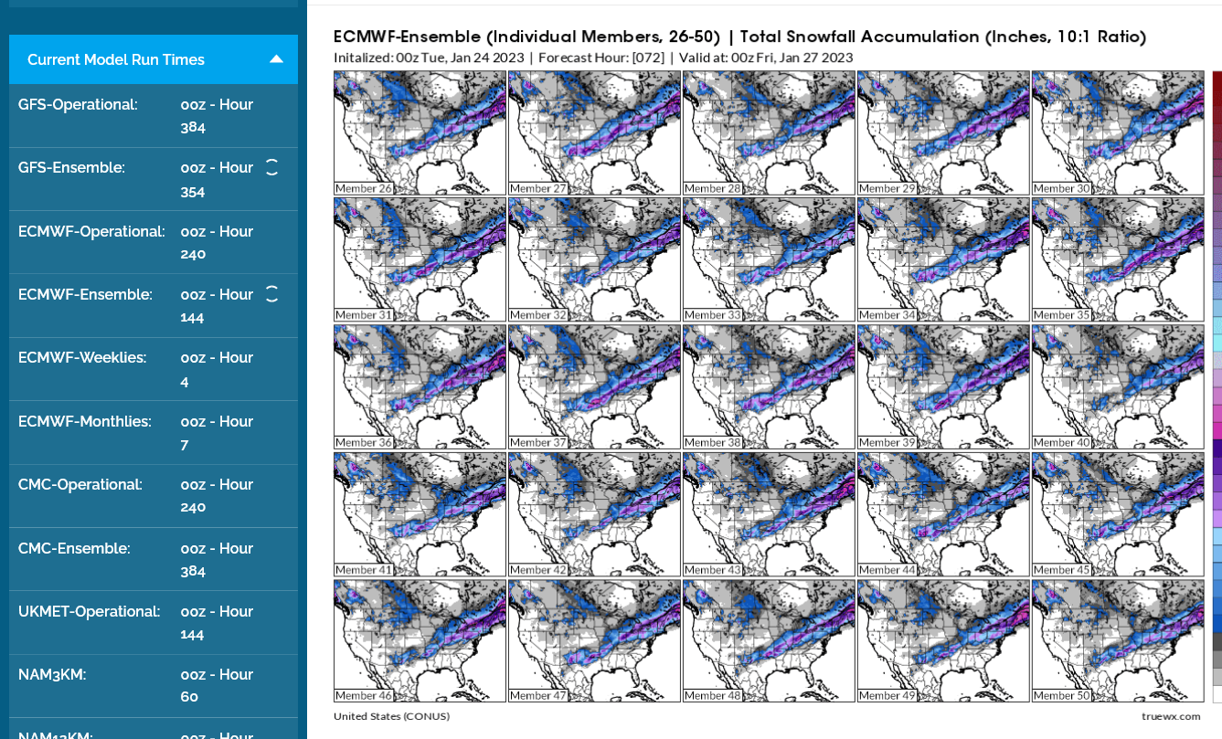
The European model ensemble average is farther north(below) with the 5+ inch pink line.
Where does the European model ensemble average above come from?
From around 50 individual members of the model with a slight variation in the equations representing the physics of the atmosphere. The equations are flawed. Some members do better with certain situations, others do better at different times. Turns out that averaging them together as a mean product is very consistent and is closest more often than any 1 member.........even though individual members will beat the average/mean almost every time.
Here they are from the 0z European ensemble above. Hard to see but even though the ones having 5 inches to northern Evansville are the minority right now, there are enough with that solution and considering the dynamic cooling Quite a few have the pink shade
If this sort of thing is extremely interesting to you, Jeff Haby is for you:
| HABY'S WEATHER FORECASTING HINTS |

The NWS has extended their Winter weather advisory farther south because of the threat of the accumulating snow from numerous ensemble members.......but still NOT the majority.......as described above.
The heavy snow is still 50 miles northwest of us on the MAJORITY of solutions.....but some solutions still have it down to Evansville....enough to MAKE THAT POSSIBLE.
Click on the map or go to the links.
Winter Storm Approaching Region
+++++++++++++++
What do I think?
I think it's a wonderful time in human history that we have the technology to follow all this stuff with guidance that is constantly being updated all day long and is being shared here.
The 12z models are coming out right now with similar solutions but still a minority that like the heavy snow down to Evansville.
Those minority solutions will be right if the surface temperature is 2 degrees colder. Evaporative and dynamic cooling in a storm like this makes that possible. I'll wait for the European operational model to come out after Noon CST, which has been the most bullish for heavy snow, almost to the Ohio River. If it backs off, then I'll back down on the snow potential.
https://www.marketforum.com/forum/topic/92398/#92446
The computer's numerical guidance has boosted it's amount of snow from .2" to .8" with this mornings guidance vs last night for Evansville/EVV. Still waiting another 30 minutes for the European operational model.
As always, everybody wants to know if there will be school tomorrow!
Sometimes it's a no brainer call. In this case, not so and I can't predict what the persons making the call will base their decision on but have some thoughts.
1. If we still have some snow days left on the calendar in the 2nd half of Winter, they may be more inclined to use 1 up, if there might be slick spots for the buses in the morning. They could make the call the evening before with that mentality.
2. Roads will be pretty warm, so unless we get more than an inch pretty fast, the roads should be just wet.
3. They may wait to make the call in the morning in a case like this and have the option for a 2 hour delay in some cases. That's often a bad idea in my opinion because it maximizes disruption and in some cases, trying to fine tune the timing can put the buses in greater harm because they don't always understand the weather enough to fine tune like that.
4. What sort of NWS official warnings/advisories are in effect for that period?
So I can guess, with at least moderate confidence, using the above as guidance, that there's a good chance of no school on Wednesday. Just a Winter Weather Advisory could be enough to justify that.
This was the last NWS snow forecast. Keep in mind that there's a lag of several hours after the guidance comes out(and I update) to when they update their products sent out to the public. I think it might get updated automatically here if not, go to this link:
https://www.weather.gov/pah/winter
The European model has some sort of a problem and is over an hour late, so let's make the forecast without my "go to" model, the one that makes the most sense here to me.
The snowfall gradient will be huge and a difference of 2 degrees near the surface will mean a difference of 4+ inches of snow.
Locations along the Ohio River may only get an inch but 50 miles northwest of there could see 5+ inches.
So, southeastern Vanderburgh County could get 1" of snow and northwestern Vanderburgh County could get 3-4 inches.
If everything shifts 25 miles southeastward, not unusual with a system like this......then most of Vanderburgh county gets 4"+. A shift northwest and it's an inch or less in most places.
What is most likely is that this will be a combination of rain and snow hitting the ground with a surface temperature ABOVE freezing the entire time NEAR THE GROUND.
It will ALL BE FALLING as snow in the clouds but encounter slightly warmer air as it falls to just above freezing near the surface and start to melt on the way down.
It will basically just be a race to see whether the snow all melts before it reaches the ground and turns to rain..........or whether it manages to barely stay as snow before reaching the ground.
I would bet that we see alot of shifting back and forth between rain to snow to rain to snow and a mixture many times. Roads are warm enough so that minor accumulations will melt and salt/chemicals are most efficient when temps are this warm.
Wednesday Night will be just slightly below freezing, so all treated roads should be ok on Thursday.
The European model did finally come out earlier, a couple hours late:
In the far southwest corner of Indiana, you can see how the forecast snow amounts go from very little to 5"(pink shade) in just a very short distance:
https://www.weather.gov/pah/weatherstory

This radar image won't help because the snow and rain look the same.

This one should help!
https://www.wunderground.com/maps/radar/current
If watching this image during the evening, you'll note the snow actually coming up from the south and replacing rain to the north, which seems extremely odd and counter intuitive.
This is the dynamic cooling taking place from the deepening storm thats appoaching from the south from the increasing vertical lift of the air.......which rapidly cools it above the surface.
Snow can fall under these conditions, even with the surface temp in the mid-30's(it doesn't hage time to melt on the way down).........which will be the case this time on the southeastern edge of the heavy snow shield.
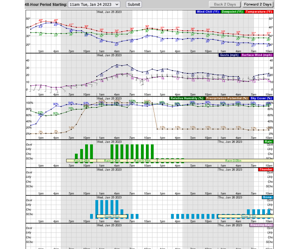
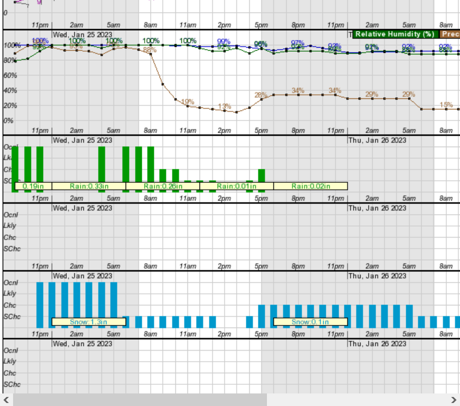
The computers numerical snow forecast number that went from .2" yesterday to .8" this morning(which I felt was too low) is up to 1.3" for Evansville now.............which I think is a better forecast.
Some of this may melt and rain may fall after it to melt it but with high confidence, the farther north and west you go from the city, the more snow there will be.
I don't think they will have school on Wednesday but they could keep everybody waiting until early morning and make the call then.
The worse things to happen in this order:
1. Have school and a bus slides off a snow covered rural road or has an accident because of the road conditions.
2. Distant #2. Cancel school the night before and then there's no snow that day because the meteorologists were wrong again (-:
3. Wait until the last minute in the morning and make a call that alot of people disagree with or think should have been made the night before, so they could all plan then..........if it's to cancel, for instance.
I wouldn't want to be the person making the call.
I grew up in Michigan in the 60's/70's and had ZERO snow days, despite numerous big snow storms and cars had rear wheel drive in those days!
We were tougher back then (-:
We have an extremely long and steep asphalt driveway.
No way to use it, with any slick spots. You'll careen off into the woods and have to be towed out.
So chemicals first as a pre treatment, then shoveling, then more chemicals are the name of the game.
But it's raining pretty hard out there now. All the chemicals would have been washed off the drive.
Some of them are being washed off the pre treated roads in the area too. However, surface temps above freezing this entire event means that we WON'T have the snow in contact with the pavement freeze up or ice up.
This is a huge deal. It means SLUSHY ROADS NOT ICY ROADS in many cases. Compacted snow can get slippery but with these warm temps, we should be more SLUSH and less slippery.
The NWS has the snow starting here between 10pm-Midnight but I'll guess midnight+ based on current conditions.
The later the start, the more that falls as rain and the less snow we get.
++++++++++++++++++++++++++++++++
In thinking more about how warm the roads are right now and how much of it will melt on the roads quickly after it falls and above freezing surface temps........I'll have to adjust my earlier position on leaning towards schools being cancelled on Wednesday.
I would lean towards having school at this point but am unsure.
The snow started shortly after 11pm, an hour before I thought but closer to the NWS time frame.
The grassy areas are covered and pavement is getting slushy.
That was a quick 2 inches of snow in just under 2 hours!
It may start tapering off here shortly.
The streets and pavement is all completely snow covered. Will be interesting to see how much of it melts on roads before its time to make the call about having school.
The snow all melted on the roads which in retrospect, considering the warm road temperatures should have been more obvious to me Earlier on.
the heavier amounts and currently falling snow is also northwest of this area.
WE'RE STILL SITTIN' ON 33 DEGREES... THE SNOW SHOULD STOP BY 5:00 PM. WE'LL BE LUCKY IF WE GET 4"
THE SNOW IS SO WET, IT WEIGHS ITSELF DOWN BY 1/2" EVERY HOUR ~ PRETTY HARD TO GET ACCURATE MEASUREMENTS, LOL
NO WIND, JUST LIGHT BREEZES
Thanks Jean!
I got 2 inches very early this morning at my house just north of Evansville but the model that I like the best, the European model got obliterated with a huge bust with the Indiana parts of the forecast.
https://www.weather.gov/pah/January24_2023Snow
.png)
Operational European model forecast below less than 12 hours before the event(close enough to usually get it right):
Pinks in Southwest Indiana in the forecast are 5-7 inches. While the highest amount above was barely 3 inches.
The warm temps/ground and change to rain also melted most of that away by the end of today.
It only remained on the roads for several hours before dawn.