This is an especially tricky one!
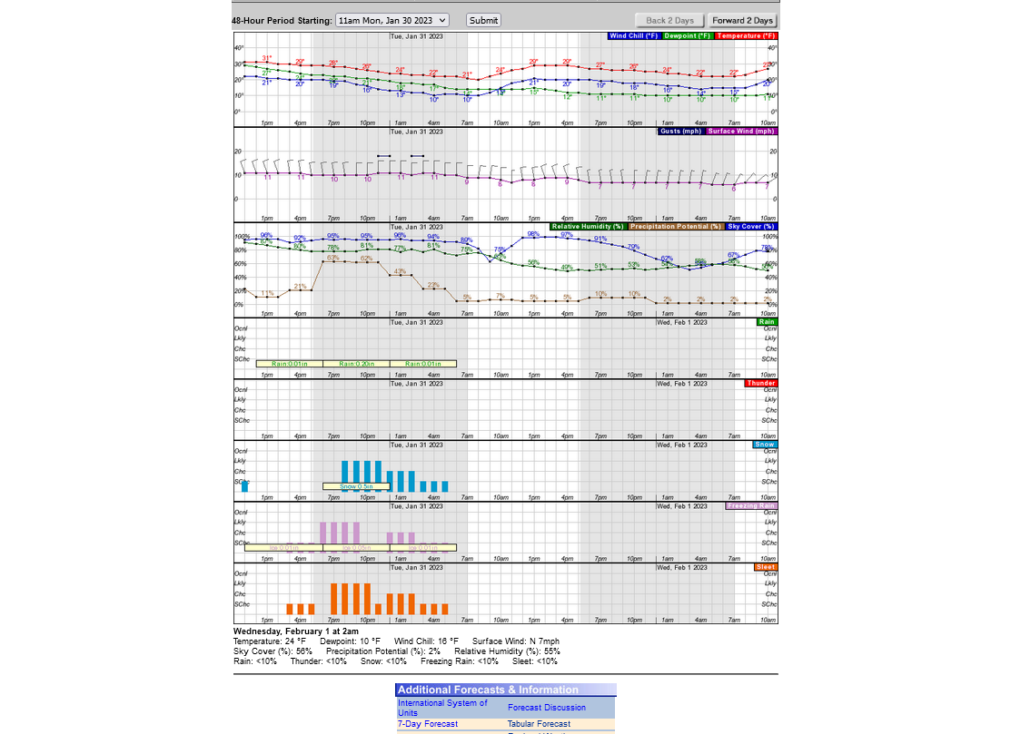
There's not going to be much moisture to work with and with AIR wtemperatures in the 50's yesterday, then 40's today, the roads should take numerous hours to drop below freezing. So we should be ok on Monday with the very light drizzle that may freeze up on elevated surfaces after awhile.
Being so light, it should be not be a problem for trees/power lines that get lightly coated.
However, Monday Night may be a problem, unless everything shifts much farther south (which could happen).
With the air aloft having a slight south to north component, there may be another round of precip.
On Monday night, the temps close to the ground will have fallen below freezing, so it may start as freezing drizzle, then as the below freezing air expands higher, it should freeze on the way down and become sleet, then maybe be cold enough from the ground to the clouds to be all snow if anything Monday Night.
Amounts will be light on Monday Night but untreated roads in places that have frozen precip, with the surface temperature dropping into the 20's, will be slick and dangerous for drivers and buses on Tuesday Morning.
However, we could get lucky and have everything shift far enough south that Kentucky has the problem with slick roads on Tuesday morning and we are dry.
Mike
Current Hazards at the link below.
Go to the link below, hit hazards box in the top right hand corner(it will also define all the color codes), if its not already in the hazards mode when you load the link.
Then you can hit any spot on the map, including where you live and it will go to that NWS with all the comprehensive local weather information for that/your county.

Latest National radar images
https://www.wunderground.com/maps/radar/current

This link below provides some great data. After going to the link, hit "Mesoanalysis" then, the center of any box for the area that you want, then go to observation on the far left, then surface observations to get constantly updated surface observations or hit another of the dozens of choices.
 |
NWS forecast office in Paducah is below, that has an area of responsibility that includes Evansville, IN. The purple shaded counties right now are those included in a weather advisory for freezing rain until 9am on Monday. As mentioned earlier, initially warm road temps should prevent serious icy road conditions early on Monday. Monday Night will be a different deal.
Here's the NWS link for forecasting freezing rain.
There's not going to be enough snow to really make a snow forecast with this one, with amounts likely to be less than an inch.
WPC Probabilistic Winter Precipitation Guidance
https://origin.wpc.ncep.noaa.gov/pwpf/wwd_accum_probs.php?ftype=probabilities&fpd=24&ptype=icez
Here's the snow...........not much at all"
You can track current conditions with the observations on these maps updated every few minutes.
LOWER MIDWEST
https://www.spc.noaa.gov/exper/mesoanalysis/new/viewsector.php?sector=20

https://www.spc.noaa.gov/exper/mesoanalysis/new/viewsector.php?sector=20#

https://www.spc.noaa.gov/exper/mesoanalysis/new/viewsector.php?sector=20# 
SOUTHCENTRAL


As expected last night(Sunday), the MAIN event is still going to be Monday night/tonight.
The worst conditions with high confidence will be SOUTH of the Ohio River, although this time around, surface temperatures will be BELOW freezing area wide so even light amounts of frozen precip could cause some travel problems on untreated roads in Indiana with temperatures dropping well down into the 20's.
Everybody always wants to know my call on school the next day.
With temps dropping well down into the 20's Monday Night, moisture on untreated roads will freeze up or stay frozen.
So no school with moderate confidence.
The main thing that will change that is if everything makes a shift south and almost no precip falls in Vanderburgh CO.
We should remember that Vanderburgh CO extends down to the Ohio River, so slick roads in the southern part of the county might mean no school for the entire county. Even though untreated roads will likely be slippery farther north too with the current scenario.
The temperature has now fallen to 32 deg. F, the low of the day at Noon and it's going to keep dropping between now and Tuesday morning.
Road temps will stay above freezing for several hours after the air temps drop colder than that but there's no stopping the huge cold air mass pouring in and its inevitable impact on roads, starting, as early as this evening.
The cold air mass coming in with north winds should dry it out enough to shift most of the moisture far enough south to keep the frozen precip light, north of the Ohio River.
It wouldn't be shocking for it to be so dry that we hardly get anything.
The temperature is down to 29 and will be dropping thru the 20's tonight, so precip on untreated roads will likely cause slippery driving.
We'll have to see if enough moisture makes it north of the Ohio River to do that. It should be starting early this evening.

Roads in Vanderburgh County are REALLY BAD right now. Numerous cars off the roads, according to my 34 year old son that was out driving. Untreated roads will only be getting worse with the current temp of 27 deg. F and falling.
I would say a near 100% chance of NO SCHOOL ON TUESDAY for the EVSC with them likely making the call shortly.
They just upgraded the weather advisory to a WINTER STORM WARNING for Vanderburgh County.
My 11th grade grand daughter that goes to NHS just told us that they called school on Tuesday.
At the higher than expected rate this sleet has been falling, we have to wonder if school could get cancelled on Wednesday too?
I would say that it will be determined by 2 elements.
1. How much falls tonight.
2. How much sun we get on Tuesday afternoon, even though temps will stay below freezing and moisture that thaws from the sun will refreeze after sunset.
We have freezing drizzle and 20 deg. F at 3am.
thats the coldest freezing drizzle I remember. The depth of this cold must be extremely shallow At the surface.
the accumulating precip only lasted for several hours, most of it over in Evansville by shortly after 9pm, so even though roads are treacherous, amounts are not that heavy.
Hey Mike,
Did you/do you know Lloyd Lindsay Young? In what year did you move to Evansville?
Larry,
I moved here in September, 1982. This was a few months after Lloyd Lindsay Young left but I heard all about him. No internet back then to see clips. He was at WFIE.
https://www.14news.com/video/2019/10/30/lloyd-lindsay-young-weathercast/
This was me in 1988 at WEHT.
https://www.youtube.com/watch?v=-w7_CLn8QSs
Another upper level wave/perturbation bringing Wintry precip to our south, with some VERY light snow this far north:
https://www.marketforum.com/forum/topic/92647/#92649
All schools are closed again, tomorrow-Wednesday. We're can't get out of our subdivision because of steep hills and completely untreated streets that are like ice(packed sleet mixed with frozen rain). Several other cars are stuck in here.
Sunny and 35 for the high should help the roads on Wednesday but moisture will refreeze Wednesday evening, so untreated side streets may still be in bad shape on Thursday?
Sunshine really melted most of the ice on sun exposed roads. However, there will be some refreezing tonight of any left over moisture.
We have round 3 of this Winter storm event taking place now........with rounds 2 and 3 each being 50 miles farther south than round 1.
There will be 0 impact in this region from round 3.
Same maps to cover round 3, except I added 3 observation maps from the SouthCentral region on the 2nd link below.
https://www.marketforum.com/forum/topic/92647/#92649
https://www.marketforum.com/forum/topic/92647/#92651
Mike said,
This was me in 1988 at WEHT.
https://www.youtube.com/watch?v=-w7_CLn8QSs
----------------------------
Holy cow, Mike! I found your lost twin and he's also a meteorologist. What a resemblance!
https://twitter.com/katcampbellwx/status/1622777736564510723/photo/1
Holy Cow is right, Larry!
My wife, Deb was amazed too. That guy does look like my twin from 40+ years ago. I just turned 67.
When people mention me being on tv, my response is often "that's when I used to be good looking (-:
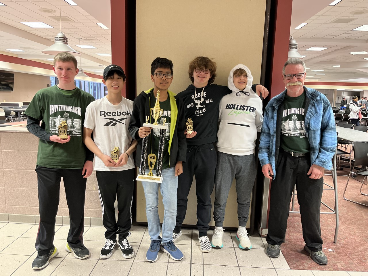
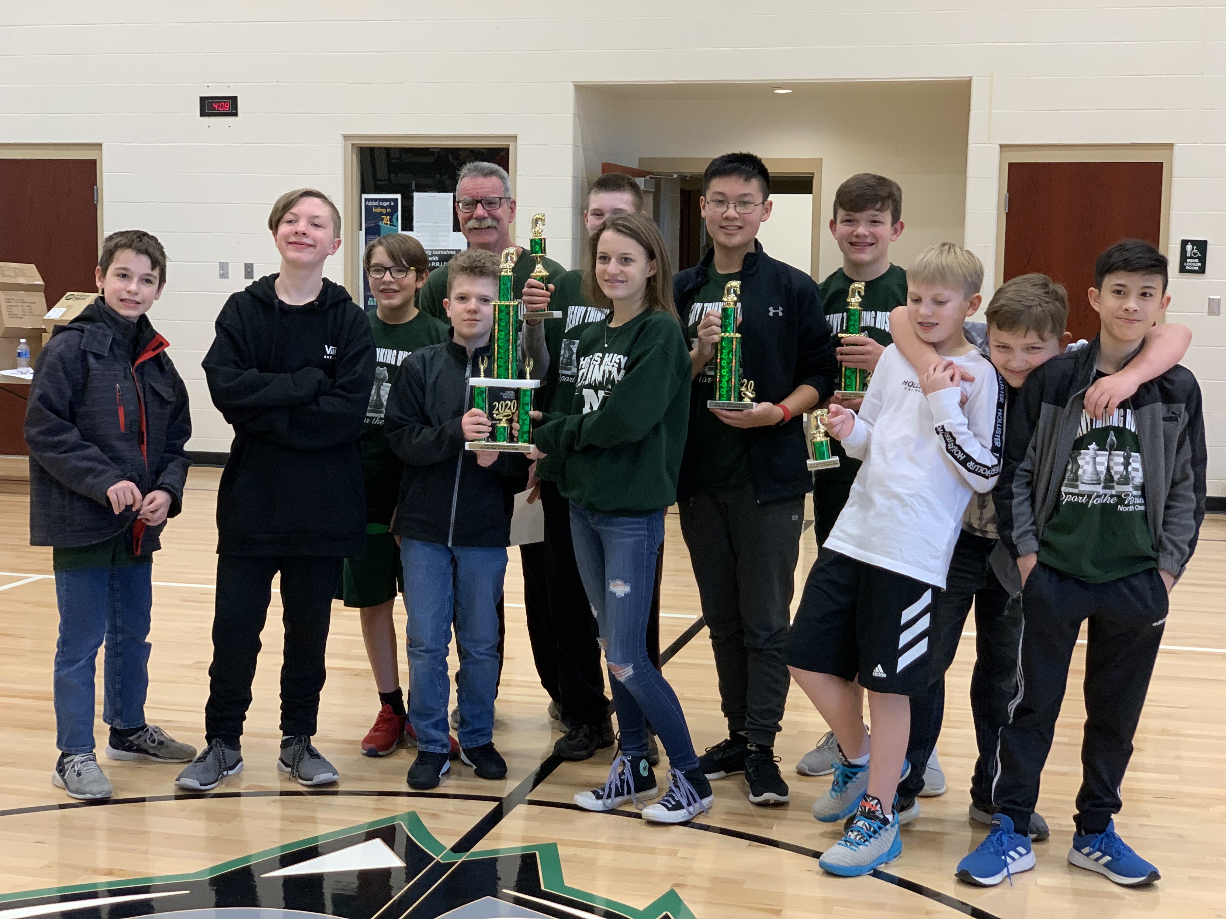
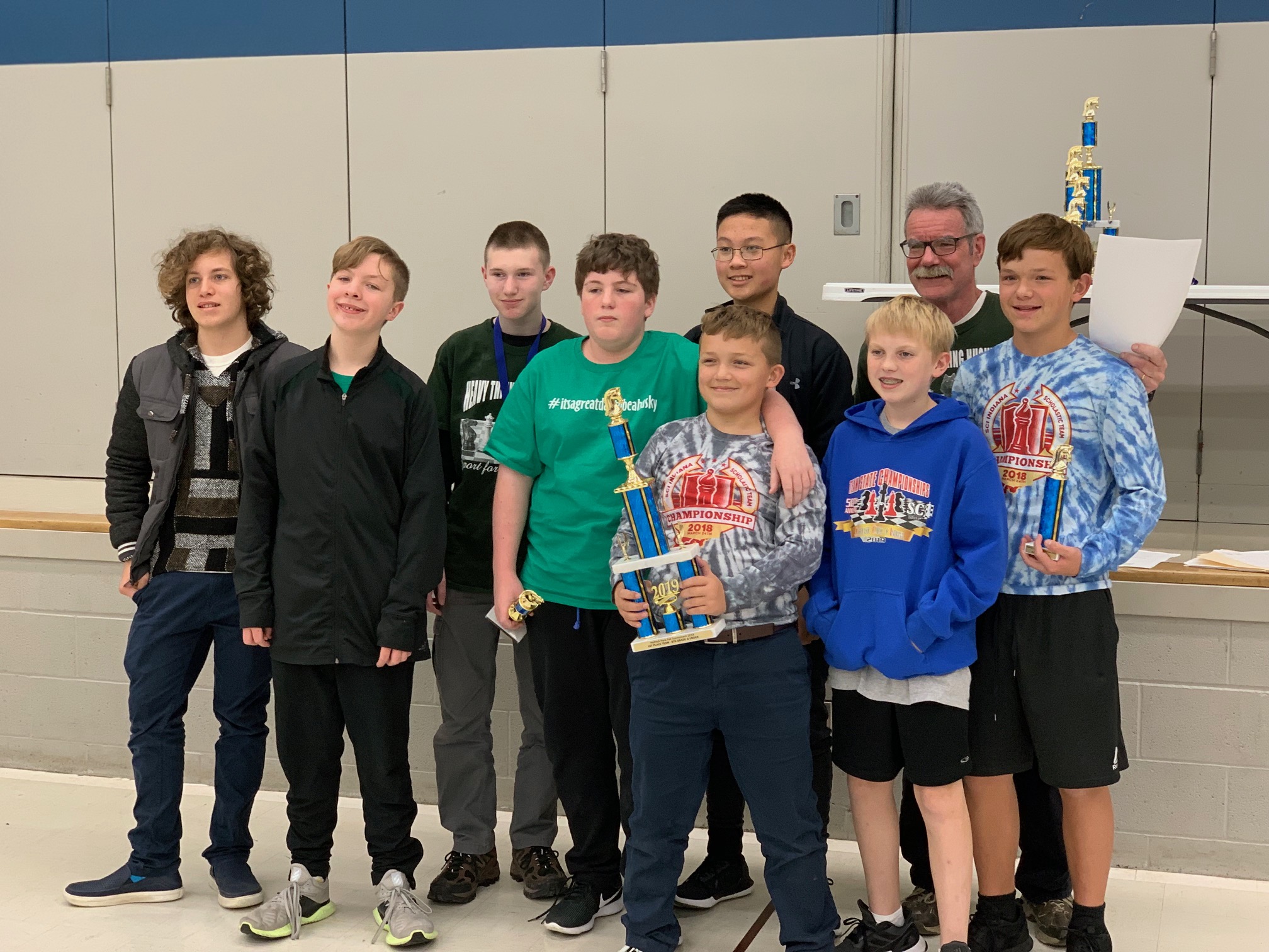
These are more recent pix
2022
2020
2019
.jpeg)
Hello, Mike
FINE CREW of Chess players. I trust you have coached them to VICTORY! Are matches played live with chess boards, or viral?
In years past, I have had a mustache and full beard. Must admit that this 70 year old best appearance is fully shaved. Looked too old 20 years ago and now look a little younger than my peers if shaven!! HaHa
Thanks tjc!
Those were just a few of the pictures that parents passed on to me from a few tournaments that I had handy.
Like with your appearance, my wife insists that if I shaved off my mustache I would look 10 years younger.
I love the mustache and it gets lots of compliments but she hates it.
I commented to her on how fast that I'm aging in the pictures(I have a serious autoimmune disorder, had 21 surgeries, 20 skin cancers and half a dozen other medical problems) and am starting to make some mental errors but I care exactly 0 about how old I look.
I honestly don't care 1 iota if I look 97 instead of 67. As long as I can still function while providing useful things to make the world better/smarter, while having a rewarding life that includes interacting with people here, doing weather/climate, trading and chess..........things are wonderful!
I actually have 324 students from 5 schools playing this year. This is a record. The largest number at 1 school, McCutchanville Elementary has 158 students from K-6 and they are doing school pictures tomorrow.
I just sent an email to be passed on to the photographer with the break down by grade because they might want to consider breaking us into 2 groups.
This year, brings the total # of kids that have played for me the past 25 years to around 4,100.
This is the upcoming annual chess tournament that I'm running:
https://www.marketforum.com/forum/topic/92277/
YOU are tremendous! Keeping thousands of what might be idle minds VIGILANT!
Again, live matches or covid viral?
What is the compelling feature to join chess club?
They are all in person, as you can see from the pictures, tjc. We had to cancel all chess for 1 year. Then we had to break up into 2 groups that met every other week the following year.
This is the first school year to be back to full strength.
 Weather Map