Regarding recorded 6/11-30 W Car/Gulf TC/STC geneses since 1851, 43% (23) of the 54 storms formed during the 53 El Nino years. That's notable considering that only 31% of the 172 seasons (53 of them) since 1851 were associated with El Niño.
Here are the 23 mid to late June recorded TC/STC geneses during El Nino years in either the W Caribbean or Gulf:
1865, 1880, 1887, 1888*, 1899, 1902 (2), 1904, 1913, 1923, 1929, 1939, 1957, 1958, 1965*, 1968 (2), 1972*, 1982*, 1986, 1994, 2006, 2015*
* notes super El Niño years. A whopping 5 of the 7 (71%) super El Niño years had one of these storms! I'm mentioning this because there's a chance that 2023 will reach super status.
This leaves 31 storms that formed during the same period in the same region during 119 non-El Nino seasons or only 26% of them.
In summary, there were 23 mid to late June W Car/Gulf storms during 53 El Nino seasons for a ratio of 43%, This compares to 31 from 119 non-El Nino seasons or a ratio of only 26%. That tells me that whereas we should take the 12 GFS runs in a row with a W Car/Gulf TCG in week 2 (as of the 6Z 6/8/23 GFS run) with a grain based on its bias toward that, we should also keep in mind that this year being El Niño means it has a significantly higher chance of occurring vs if it weren't El Niño.
That's incredible work, Larry!
Thanks extremely much. Comments in a minute.
OK, that was a minute as seen from the eyes of Father time (-:
Sorry for the delayed comment. I started a reply and kept getting sidetracked.
That's a fascinating stat showing the tropical storm season in El Nino years often gets off to a fast start, especially with sea temperatures around 1 deg. C less in the first half of that era.
Eric kicked off his discussion with this today:
Record warm temps in the tropical Atlantic.
https://www.ospo.noaa.gov/Products/ocean/sst/contour/
https://www.ospo.noaa.gov/data/sst/contour/satlanti.c.gif
https://www.ospo.noaa.gov/data/sst/contour/gulfmex.c.gif
The 6/9 18Z GFS is the 18th run in a row with a TC forming in the W Caribbean and then moving into the Gulf. Despite the GFS having gone much longer in past years than 18 straight runs for what turned out to be fakes and despite the Euro ens continuing to be very quiet, I'm admittedly a bit more wary than normal about the chance that this is real based on the higher level of June activity on average preceding +1.3+ ASO El Ninos and considering that ASO in 2023 is headed there.
No mid to late June W Car/GOM TC/STC formation: ASO ONI
0.5, 0.5, 0.5, 0.5, 0.6, 0.6, 0.6, 0.6, 0.6, 0.7, 0.7, 0.7, 0.8, 0.8, 0.8, 0.8, 0.8, 0.8, 0.9, 1.0, 1.0, 1.1, 1.2, 1.2, 1.4, 1.6, 2.1, 2.2
Mid to late June W Car/GOM TC/STC formations: ASO ONI
0.5, 0.6, 0.6, 0.7, 0.7, 0.8, 1.3, 1.3, 1.6, 1.6, 1.6, 1.6, 1.9, 2.2
So, for ASO of 0.5 through 1.2, there were only 6 of these W basin mid to late June formations from 30 years (20% ratio). But things really start picking up in June when the subsequent ASO is 1.3+ with 8 formations from just 11 years (73% ratio).
Larry,
This is really great stuff that you're sharing. I'm having to educate myself to catch up to your level of tracking and interpreting some of these indicators. Thanks for helping to advance my/our knowledge and understanding.
12z GFS continues with the phantom tropical system that Larry, alerted us to. Here it is at day 10. Almost no ensemble support or from other models. It's been there for several days on every run of just the GFS.
The 18Z GFS is the 22nd GFS run in a row with a W Car formation within 6/17-9 that later becomes a hurricane. The GFS is notorious for phantom TC formations in and near the Caribbean, especially early and late season.
I can't call it a phantom or fake storm until we get past 6/19 and I see no imminent formation. Despite the lack of Euro ensemble support and the reputation of the GFS for often producing phantoms, I'm a bit more wary about the chance of this not being a phantom because of the earlier posted more active June climo for stronger El Niño events, which we appear to be heading to.
Make that 23 in a row now, Larry with this last 0z GFS.
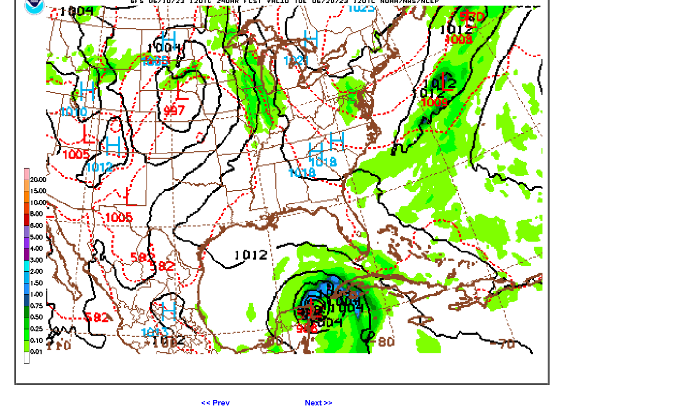
The GFS keeps "Bret" around for a week before it finally goes up the East Coast at the end of the period on this solution.
I believe you that this isn't completely unusual for the GFS. However, do you think that the number of consecutive solutions like this is close to some sort of record?
Hey Mike,
Make that 24 with today's 6Z GFS, which gets it to TS strength before weakening over the Yucatan.
No, 24 isn't near the record, which I recall getting to somewhere into the 30s. So, we need another two days to approach the record.
Thanks, Up to 25 now, Larry!
You'll like these posts from yesterday on Twitter!
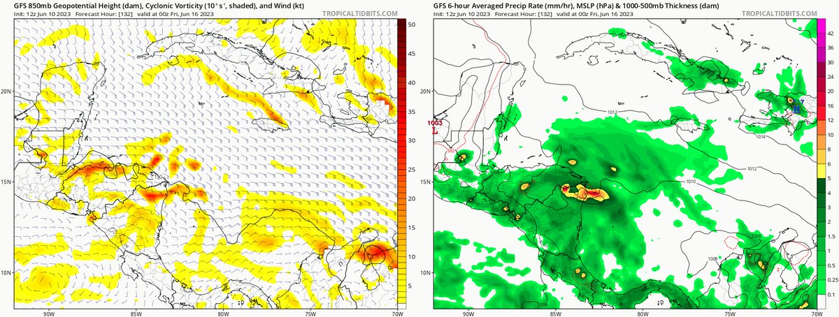
The GFS commonly develops fictitious storms in the western Caribbean. Typically, these arise from the aggregation of multiple small-scale vorticity perturbations (left panel) caused by and collocated with strong bursts of convection/precip (right panel). While the GFS is not always wrong about the existence of these localized convective bursts, they are often way too strong, leading to small areas of intense vorticity/spin that eventually aggregate upscale into a tropical cyclone circulation, as we can see here on today's 12Z model run. This is why the GFS is difficult to take seriously when it predicts TC formation, unless other models show a similar forecast. This is especially true in the western Caribbean, where the GFS has an extremely high false alarm rate. Know your weather model before you trust its output!
97.1K Views76 Retweets9 Quotes478 Likes
Dr. Cowan, if that same vorticity perturbation on a 384 hour map still exist at hour 168, then confidence is higher as a trending developing system compared to something that appears at hour 384 and disappears the next model run as a phantom vorticity perturbation.
You're right that as a general rule, the shorter the lead time, the higher the forecast confidence. Unfortunately, we've seen the GFS exhibit this particular error even at short lead times of a few days.
I thought within the past two years, a new GFS forecast model was born 4 better confidence 4 NHC ATL replacing the older GFS? I tend 2 like GFS better because it has more model runs than the ECMWF. But, most all local forecasters here in FL have confidence w/GFS w/in 168 hrs.
Dr. Levi Cowan@TropicalTidbits·
The June NMME sea surface temperature anomaly forecast for summer/fall continues to trend further toward two bands of warmer than normal water that are pretty opposed to each other in terms of their typical impact on the Atlantic hurricane season. Confidence in the overall level… Show more
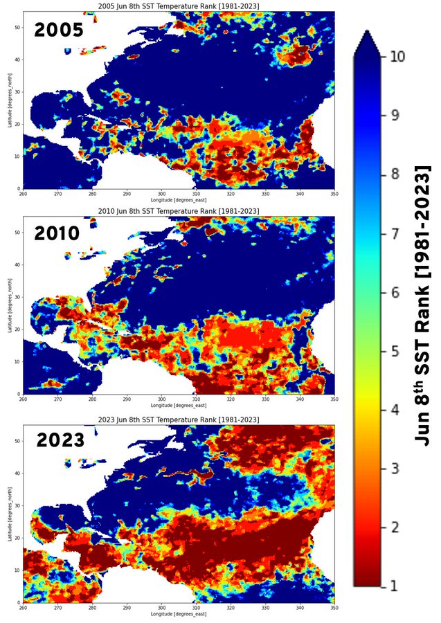
Couple of people asked about 2005 and how the SSTs on Jun 8th would rank - so here's 2005 the notably warm 2010, too:
Hey Mike,
Indeed, the tropical Atlantic is insanely warm!! No other season on record has been seen like this as of June. Combined with the Pacific tropical warmth from the oncoming strong El Niño makes this an even more unique and thus hard to predict Atlantic tropical season.
The GFS tropical system streak of consecutive tropical systems just ended at 25 with this last 18z run.
One would think there's a great chance for it to return and 1 run means nothing. In fact, all the other runs meant very little at that distant time frame.
Mike said:
"The GFS tropical system streak of consecutive tropical systems just ended at 25 with this last 18z run."
----------------------
Hey Mike,
The streak didn't end. The 18Z has a strong TS (987 mb) on June 20th just E of Belize moving westward. So, it is up to 26 straight runs.
Thanks, Larry I don't know what I was looking at earlier but see what you pointed out. Sorry about that!
Hey Mike,
We'll, maybe you had a premonition because just one run later the streak's life ceased:
GFS streak: 12Z June 5th, 2023-18Z June 11th, 2023 RIP
It was 26 runs old.
It had a pretty long life though not near a record breaker. This streak will always be remembered for its tenacity.
No longer there on the 6z model either.
Related to the record warm tropical Atlantic for this time of year, San Juan has just had its warmest June 1-11 on record, 86.9 F. Furthermore, it is the warmest by a good margin. The old record warmth was down at 85.3, set in 1988. The record coolest is 77.5, set in 1922, 1913, 1914, and 1939.
https://www.weather.gov/wrh/Climate?wfo=sju
They've had a mere 0.02" of rainfall so far this month, 1% of their normal of 1.87" for June 1-11.
The record warm tropical Atlantic is at least partially being blamed on near record low for this time of year Saharan dust being blown into the Atlantic.
https://michaelrlowry.substack.com/p/its-saharan-dust-season-but-wheres