Mike's Weather Page
ENSO: Recent Evolution,
Current Status and Predictions
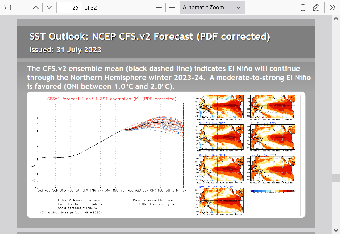
El Nino continues to slowly strengthen. Now moderate headed stronger late this year. It is and will continue to warm global air temperatures(by several 10ths C.) well into 2024.
The Pacific Ocean is 2/3rd of the world oceans and contains the majority of the heat in the ocean/atmosphere. The tropical Pacific is the most important location on the planet for determining global weather and short term global temperatures.
Here's a new source that I found. Not saying how good they are but they clearly have a good understanding of the atmosphere/oceans.
Climate Impact Company
https://climateimpactcompany.com/
Who We Are
Climate Impact Company is a leading provider of analysis and consultation to industry, mainly energy and agriculture deciphering model data and climate signals to produce our own products for the specific needs of our clientele. Our forecast process is unique with an impressive track record since Climate Impact Company formed in May of 2004.
What We Do
Climate Impact Company is obsessed with making the best month-to-month and seasonal climate forecast possible for all sectors of the globe. We branch the seasonal climate outlooks to the short-range forecasts with our unique week 2-4 outlook. Climate Impact Company monitors and forecasts all climate signals from ENSO to NAO/PNA to AMO/PDO to soil moisture and snow cover. Climate Impact Company has a 2-decade track record of forecasting seasonal tropical cyclone activity including ACE index.
07/31/2023, 1:47 pm EDT
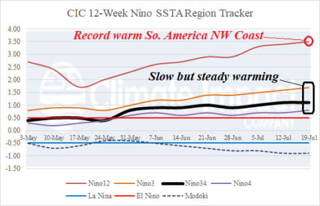
The Nino34 SSTA warmed to +1.2C last week as oceanic El Nino strengthens to moderate intensity. The ENSO climate budged toward El Nino in July as supported by a 2-to-3-week period of a negative southern oscillation index (-SOI) although SOI has shifted into weak positive phase the past 2 days.
07/30/2023, 12:51 pm EDT
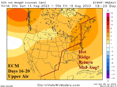
In 10-15 days, possible changes are looming. The global atmospheric angular momentum (GLAAM) pattern may flip negative for the first time during the summer season signaling a slowdown in the upper air pattern. If so, recent much warmer GFS 11-15-day forecasts and the ECM 16-20/16-30-day forecasts may regenerate another fierce hot upper ridge pattern for mid-to-late August.
07/25/2023, 5:30 am EDT
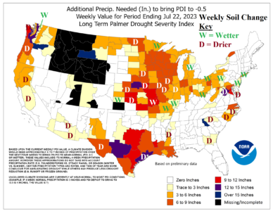
Yesterday’s rainfall needed to neutralize dry Palmer Drought Severity Index (PDSI) analysis from NOAA/CPC revealed the Midwest U.S. Drought worsened last week. Short-term forecasts indicate searing heat risk increase and limited rainfall ahead into next week as the drought will continue to worsen.
07/24/2023, 11:50 am EDT
Oceanic El Nino continues to slowly strengthen and is now at moderate intensity. Subsurface warming is convening in the eastern equatorial Pacific to provide more ammunition to strengthen El Nino. However, the sustained 1-2-month-long negative southern oscillation index required to generate an El Nino climate has not yet materialized.
07/23/2023, 3:41 pm EDT
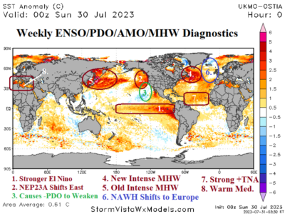
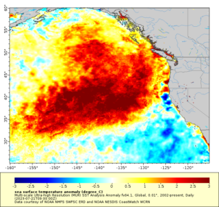
The Northeast Pacific marine heatwave “NEP23A” has intensified and shifted east during the past several weeks. Meanwhile, a dramatic change in the North Atlantic SSTA pattern has emerged causing weather pattern changes and extreme events.
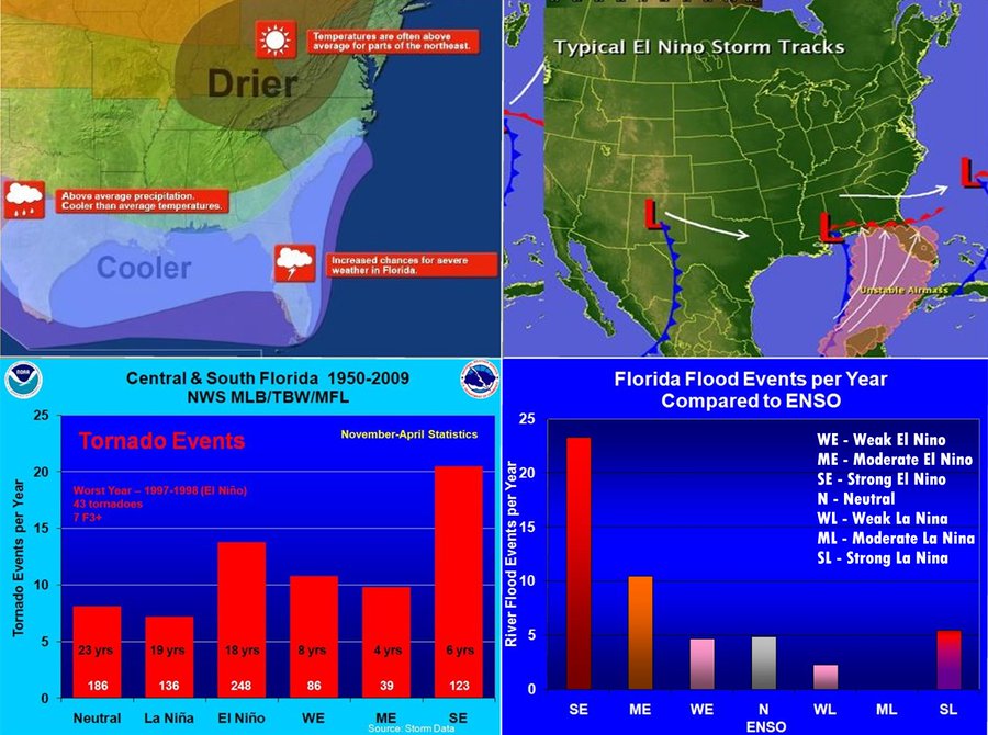
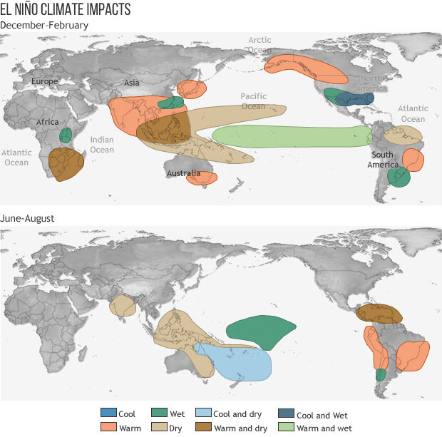
Mike's Weather PageEl Nino in the winter brings a lot of weather for the southeast, especially Florida. History shows much higher rains... and much higher severe storm chances (including Tornadoes). All due to jet stream placement. So far the El Nino outlook is in the ME/SE range. http://spaghettimodels.com
·
22.4K Views
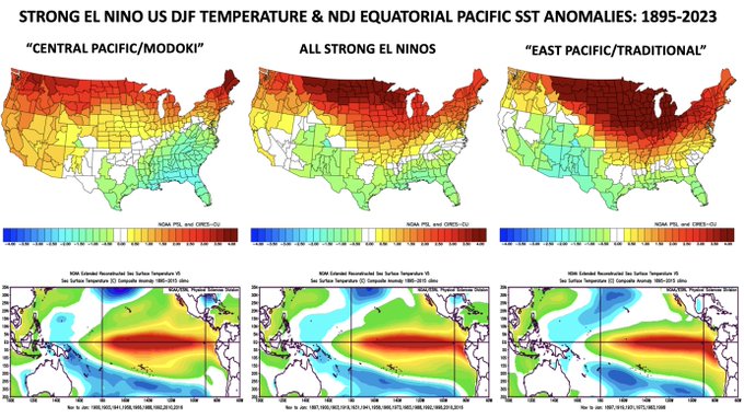
Here's a quick look at US Dec-Feb (DJF) temperature anomalies (top row) & Nov-Dec (NDJ) tropical Pacific SST anomalies (bottom row) for strong El Niños sorted by the placement of SST anomalies in the equatorial Pacific (using the Trans Nino Index (TNI)). We're likely going to be… Show more
https://www.climate.gov/news-features/blogs/august-2023-el-ni%C3%B1o-update-back-school
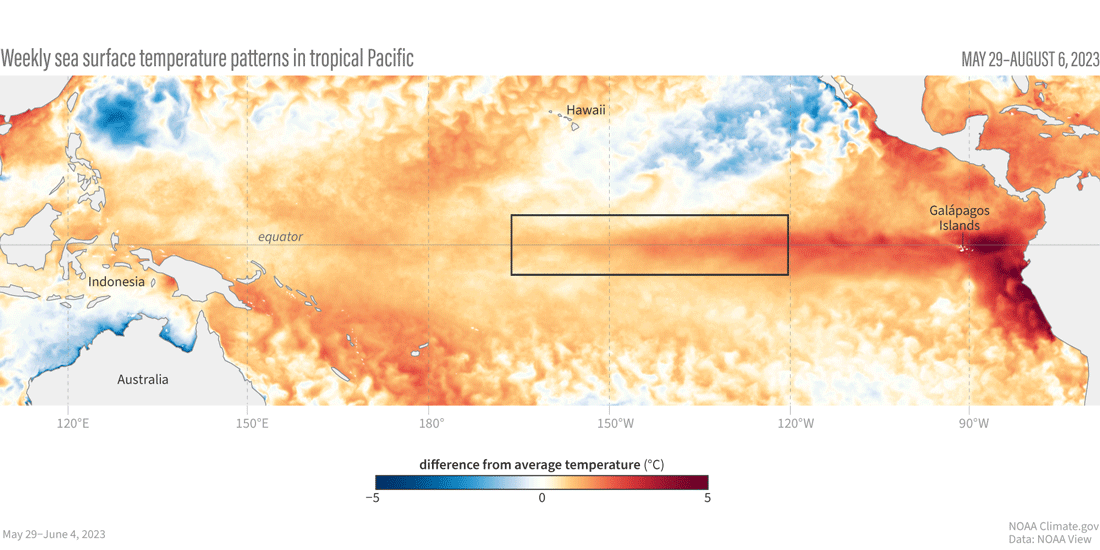
Animation of maps of sea surface temperatures in the Pacific Ocean compared to the long-term average over five-day periods from the end of May to early August 2023. The waters in the key monitoring region, which scientists call "the Niño-3.4 region," progressively become warmer than average (red) as El Niño builds. NOAA Climate.gov, based on Coral Reef Watch maps available from NOAA View.
++++++++++++++++++++++++++++++++++++++
ENSO: Recent Evolution,
Current Status and Predictions
Update prepared by:
Climate Prediction Center / NCEP
14 August 2023
https://www.cpc.ncep.noaa.gov/products/analysis_monitoring/lanina/enso_evolution-status-fcsts-web.pdf